| Pages:
1
2
3 |
David K
Honored Nomad

Posts: 64551
Registered: 8-30-2002
Location: San Diego County
Member Is Online
Mood: Have Baja Fever
|
|
Whatever...
The Mexican map clearly shows them as dry or seasonal LAKES! In the Lower Ca Guidebook map it even has "(dry lake)" written right below "Llanos de
Hiray" as well as at Llanos de San Julio by Comondu. That too is a dry lake (most of the time).
Again, I didn't invent any of this, it is right there for all to see, on the maps and in person.
[Edited on 8-6-2004 by David K]
|
|
|
Debra
Super Nomad
Posts: 2101
Registered: 10-31-2002
Location: Port Orchard Wa./Bahia de Los Angeles BC
Member Is Offline
|
|
Knock it off you guys....
I just got home and you are giving me a head-ache 
Tucker: As you probebly heard I had major car problems on my trip down so I didn't make it as far as I wanted. Anyway, thank-you for the offer of
you hospitality, next time.
|
|
|
Tucker
Senior Nomad
Posts: 664
Registered: 10-31-2002
Location: El Centenario, BCS
Member Is Offline
|
|
Hi Debra
I just got back from CA a few days ago........Ditto, major car problems!
\"I think it would be a good idea.\"
-- Mahatma Gandhi, when asked what he thought of Western civilization
|
|
|
jrbaja
Ultra Nomad
Posts: 4863
Registered: 2-2-2003
Member Is Offline
|
|
Llano
means level or plain. If anyone basis their information on what the gringo maps say or the Baja Almanac, you are being fed wrong information.
Only when it comes to place names or actual routes though.
One of the problems with getting information regarding Baja out of books rather than personal experience is that a lot of it will be based on other
wrong information.
|
|
|
Tucker
Senior Nomad
Posts: 664
Registered: 10-31-2002
Location: El Centenario, BCS
Member Is Offline
|
|
La lluvia en Espa?a cae principalmente en el llano.
\"I think it would be a good idea.\"
-- Mahatma Gandhi, when asked what he thought of Western civilization
|
|
|
jrbaja
Ultra Nomad
Posts: 4863
Registered: 2-2-2003
Member Is Offline
|
|
|
|
|
elizabeth
Senior Nomad
Posts: 742
Registered: 7-30-2004
Location: Loreto, BCS
Member Is Offline
|
|
This was fun...and David K thanks for the correction on Walker...I had forgotten that although his unpopular (at least to Nicaraguans) incursion into
Nicaragua was the start of the end, that he actually was executed in Honduras.
|
|
|
academicanarchist
Senior Nomad
Posts: 978
Registered: 9-7-2003
Member Is Offline
|
|
Answers #1 and #2
David. Have you received correct answers to 1 and 2?
|
|
|
David K
Honored Nomad
Posts: 64551
Registered: 8-30-2002
Location: San Diego County
Member Is Online
Mood: Have Baja Fever
|
|
No Robert, nobody has even taken a stab at #1 other than to say they think it was in a book. I did give a hint that it can be found in my web site. A
new hint: It is a mission as seen about 1905/6.
#2, Elizabeth gave most, but not all of the answer (she left out one word that makes this place unique over the other San Juan Bautistas in Baja).
|
|
|
David K
Honored Nomad
Posts: 64551
Registered: 8-30-2002
Location: San Diego County
Member Is Online
Mood: Have Baja Fever
|
|
| Quote: | Originally posted by jrbaja
means level or plain. If anyone basis their information on what the gringo maps say or the Baja Almanac, you are being fed wrong information.
Only when it comes to place names or actual routes though.
One of the problems with getting information regarding Baja out of books rather than personal experience is that a lot of it will be based on other
wrong information. |
Yes, and 'laguna' means lagoon, so what... ?
MEXICAN OFFICIAL GOVERNMENT MAPS are where the Baja Almanac comes from. Several dry lakes in Baja Sur have Llano in their name on those maps, that is
where the trivia question comes from, I didn't make any of this up, I am not creating bogus information.
Howard Gulick in 1955 + mapped Baja... his information on place comes from interviewing LOCALS. 'Llanos de Hiray (dry lake)' is on his map. It is a
dry lake north of today's Puerto Cancun road (south of the Puerto San Carlos highway).
The other 'llanos' I see on the Mexican topos are near Comondu and Purisima.
A plain (also 'llano') is a much larger level area, as in the Magdalena Plain around Constitucion. But' a 'plain' is not an area the fills with water
after rain or floods and is dry the rest of the time. Also they are not a few miles or less across as are the numeros 'llanos' near Comondu, shown on
the maps as seasonal or dry lakes.
If you don't like the Mexican people of Baja Sur calling dry lakes 'llanos' for 50+ years, then take it up with them, I am just saying what is on the
maps.
|
|
|
David K
Honored Nomad
Posts: 64551
Registered: 8-30-2002
Location: San Diego County
Member Is Online
Mood: Have Baja Fever
|
|
Elizabeth Wins #2
Yes, it is SAN JUAN BAUTISTA de LONDO... just west of Hwy. 1, between Bahia Concepcion and Loreto. Established as a vista for the Loreto mission in
1699, with constuction of the stone church in 1705, making it one of the oldest sites on the peninsula! Some have even considered it a seperate
mission, as it was a very substancial structure with ornate carvings in the stone. It was abandoned about 1750.
|
|
|
surfer jim
Super Nomad
Posts: 1891
Registered: 8-29-2003
Location: high desert
Member Is Offline
|
|
Well now this proves there are planes on the plains....
|
|
|
jrbaja
Ultra Nomad
Posts: 4863
Registered: 2-2-2003
Member Is Offline
|
|
So Laguna Hanson
is a lagoon ??
|
|
|
Barry A.
Select Nomad
Posts: 10007
Registered: 11-30-2003
Location: Redding, Northern CA
Member Is Offline
Mood: optimistic
|
|
Number #1 historic photo
David----I know what number 1 is, and I have u2u'ed you with the answer.
Best, Barry
|
|
|
Barry A.
Select Nomad
Posts: 10007
Registered: 11-30-2003
Location: Redding, Northern CA
Member Is Offline
Mood: optimistic
|
|
Laguna
JR----laguna also means "pond" and Laguna Hansen is certainly at least, a pond. Barry
|
|
|
academicanarchist
Senior Nomad
Posts: 978
Registered: 9-7-2003
Member Is Offline
|
|
Barry A.
Barry. if you want to, you can send me a message as well regarding #1, but I would guess that you checked out David's mission web site.
|
|
|
Barry A.
Select Nomad
Posts: 10007
Registered: 11-30-2003
Location: Redding, Northern CA
Member Is Offline
Mood: optimistic
|
|
am I being accused of cheating????
AA----absolutely, unequivically, and under no circumstances did I consult David's sources of info------I just remember that I was with that guy that
took that picture (at least sometimes I feel that old).
Actually, I have an extensive library of my own, and I remebered seeing that pic. in one of my books.
Best, Barry
|
|
|
David K
Honored Nomad
Posts: 64551
Registered: 8-30-2002
Location: San Diego County
Member Is Online
Mood: Have Baja Fever
|
|
Barry A. is Question #1 Winner
... as he was the first with the correct answer. Elizabeth was close when she guessed Purisima Vieja. However the photo by Arthur North in his 'Camp
and Camino in Lower California' is of the second and final location for Mision La Purisima Concepcion. Only rubble and graves mark the site today, as
seen in the photo by Jack Swords in my missions web site. This North photo is also there, thanks to AA: http://vivabaja.com/bajamissions (and click on La Purisima link).
[Edited on 8-7-2004 by David K]
|
|
|
David K
Honored Nomad
Posts: 64551
Registered: 8-30-2002
Location: San Diego County
Member Is Online
Mood: Have Baja Fever
|
|
So far...
Barry A. wins #1 (Mision La Purisima)
Elizabeth wins #2 (Visita San Juan Bautista de Londo)
Mexitron wins #3 (La Tijerita knew this as well): Many, if not most dry lakes in Baja Sur are called 'LLANO' (which in Spanish also means a plain),
several examples were given... It is unusual, and hard for most to accept this word because in Baja Norte, only LAGUNA is used.
#4 is still open, although a few of you have given some correct names (see seperate reply on this, below)
#5 Elizabeth wins this with the correct answer of William Walker and she included some additonal history, to boot!
ALL contestants may receive my brand new, printed by BajaCactus in Tijuana, "got baja?" stickers if you send me your mail addresses.
Natile and Barry, I cannot respond to any U2Us just yet, I can see them... but I cannot reply until more of my U2Us are deleted.. So, if anyone is
saving a U2U from me, please delete them if you are finished reading... Thanks!
|
|
|
David K
Honored Nomad
Posts: 64551
Registered: 8-30-2002
Location: San Diego County
Member Is Online
Mood: Have Baja Fever
|
|
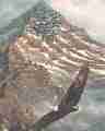
PICACHO DEL DIABLO's other names:
From John Robinson's Camping and Climbing in Baja (La Siesta Press c1967 and many editions following)....
Early Spanish explorers called it LA PROVIDENCIA due to the snow seen ,above the burning desert.
Early U.S. Navy charts starting in 1880 called it CALAMAHUE MOUNTAIN, somtimes it was called SANTA CATALINA MOUNTAIN (after nearby missions, although
Calamajue wasn't near).
SAN PEDRO MARTIR MOUNTAIN and EL PICACHO BLANCO appeared around 1900.
The official name used by the Mexican government is CERRO LA ENCANTADA, after the nearby meadow, but few locals call it that.
So, of the six names above, none are as popular as the name we all know it as: EL PICACHO DEL DIABLO, 10,154 feet ASL.
A couple of you gave two answers, but not close to the total of 6.
I hope this was fun, and sorry if it offended anyone. My information comes from published material and I did not make up any answers, including
calling a dry lake a 'llano'! Viva Baja everyone!
|
|
|
| Pages:
1
2
3 |