David K
Honored Nomad

Posts: 64480
Registered: 8-30-2002
Location: San Diego County
Member Is Offline
Mood: Have Baja Fever
|
|
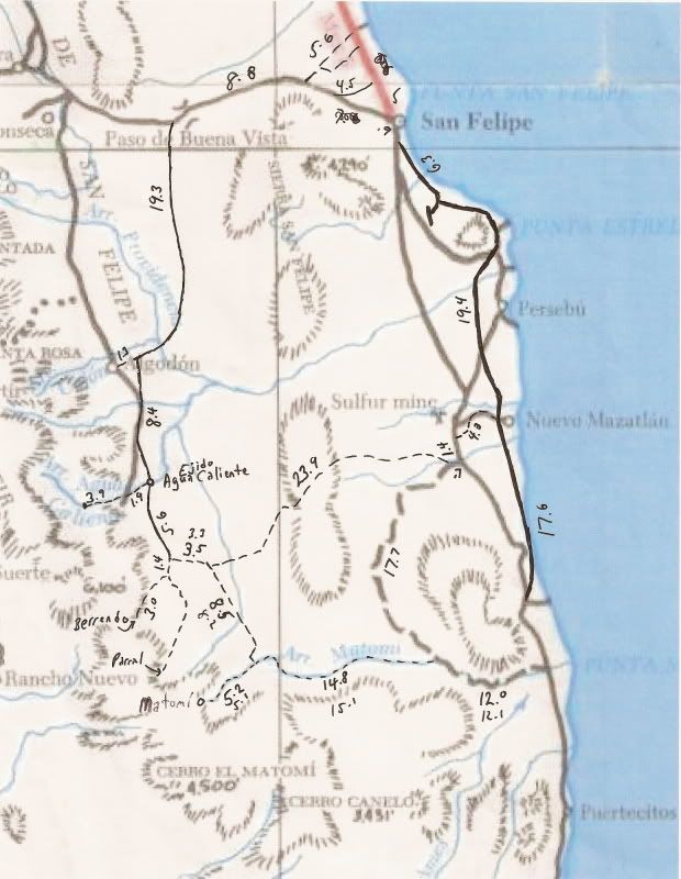
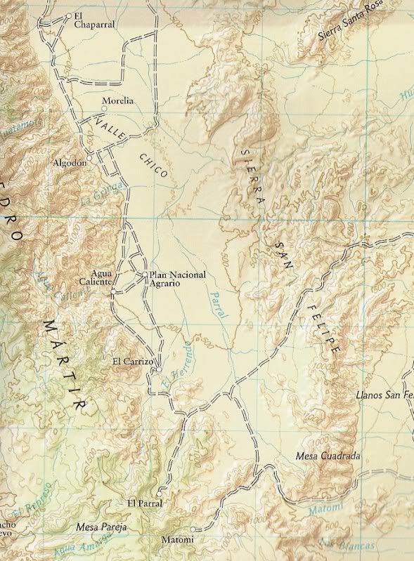
Agua Caliente Hot Spring (Valle Chico) on maps
The very interesting thermal springs inside Agua Caliente Canyon (east slope of the Sierra San Pedro Martir, facing San Felipe) has been on maps for
almost 100 years... in a region one map shows as 'unexplored'!
1919:
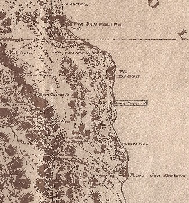
(note east of Agua Caliente: 'Agua Charley' circled on the coast... later Mexicanized into 'Agua de Chale' and today is Nuevo Mazatlan. Named for a
well dug by 'Charley the Chinaman' to water his goats.)
1930:
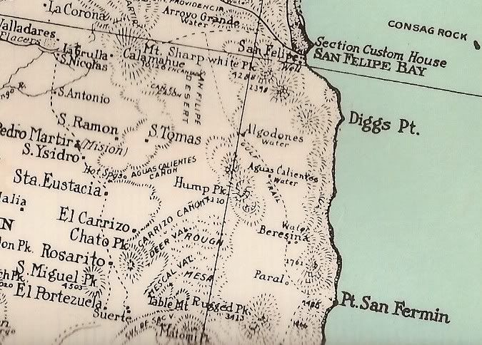
Great map for detail, but some errors: Algodones shown too far east, a second Aguas Calientes shown, 'Paral' too far east...
1941:
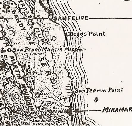
(note: 'Unexplored') in Valle Chico
1962:
Howard Gulick (Lower California Guidebook) made the first modern, accurate maps of Baja.
1972:
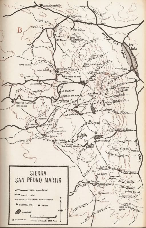
(Third edition of 'Camping and Climbing in Baja', detailed the roads and canyons facing Valle Chico in 1967)
1975:
(some additions by me in '06 to the Baja Calif. Guidebook map)
1982:
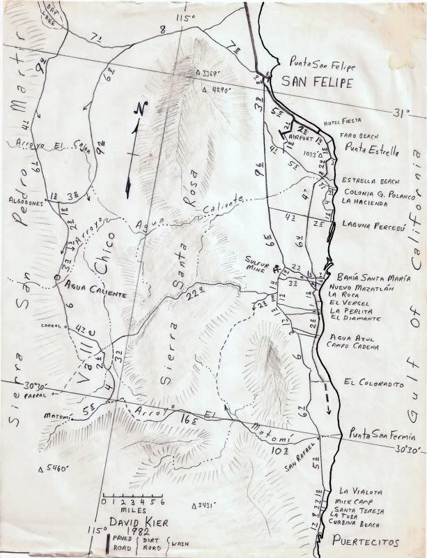
(One of my maps)
2003:
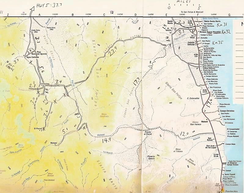
(Baja Almanac with additions by me in 2006, every road showing a mileage I have traveled. X'ed roads were abandoned before my first map trips in
1978.)
2008:
Nat'l Geo. map with long abandoned old roads and missing some other roads.
Next, Satellite images of the canyon...
|
|
|
David K
Honored Nomad
Posts: 64480
Registered: 8-30-2002
Location: San Diego County
Member Is Offline
Mood: Have Baja Fever
|
|
Agua Caliente Canyon from Space
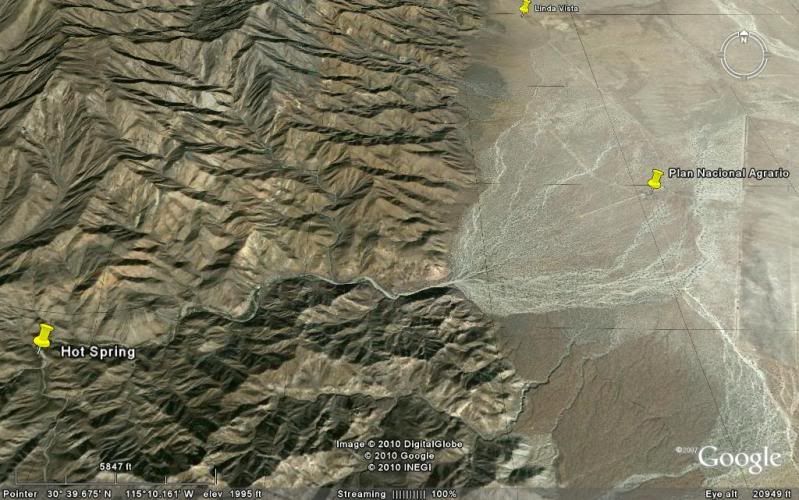
Straight down, north at top
Looking west into canyon mouth
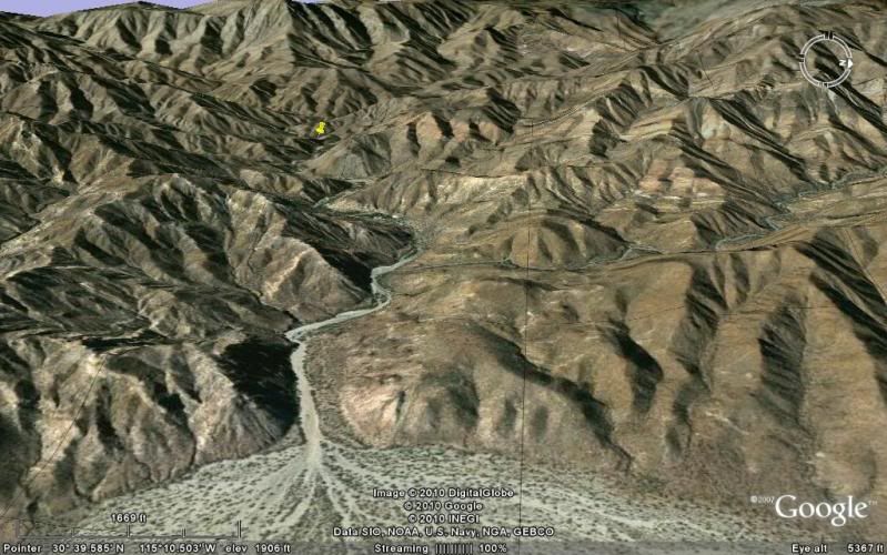
Midway to the hot springs
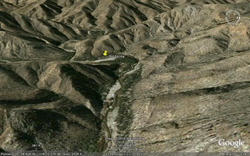
Near the springs. The trees on the right side of the canyon are on a bench a couple feet higher than the mountain stream. This is were the marijuana
fields were planted after our Jan. 1, 2001 visit. My next visit in 2004 showed all the drip irrigation lines hacked up from the military. See photos
in next installment...
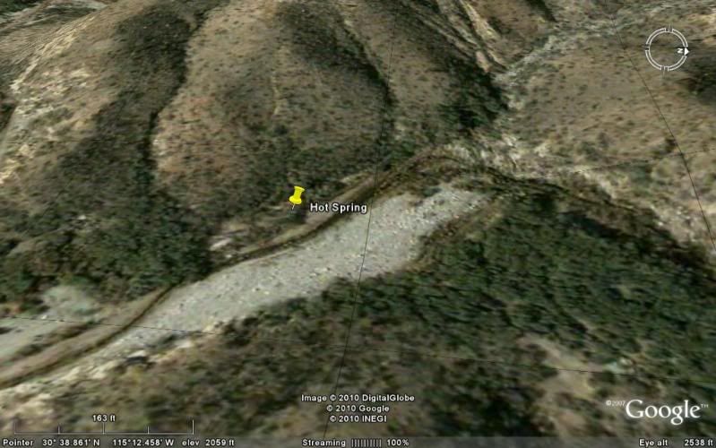
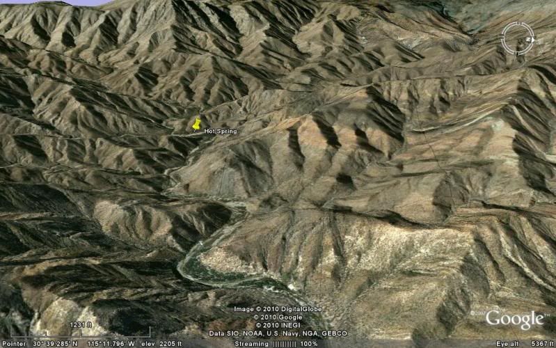
Looking down on the springs. The hot water stream blends with the cool mountain stream near where the canyon bends 90º from north to east in direction
of flow.
[Edited on 1-8-2011 by David K]
|
|
|
David K
Honored Nomad
Posts: 64480
Registered: 8-30-2002
Location: San Diego County
Member Is Offline
Mood: Have Baja Fever
|
|
Jan. 1, 2001...

Uplanted field under shade trees using drip tape for irrigation.

Hot Spring location in Agua Caliente Canyon. Photo looking north, down the stream from where we came. The hot stream is to the left of the tub and
flows hot for a good distance before joining the cool stream.
The Source Spring
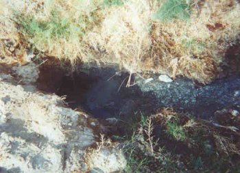
Bubbles come up and a large quantity of extremely hot water flows from this spring hole. A couple other springs are close by in the brush.

Baja is incredible...here two spring flows of super hot water join and flow about a hundred feet where they join the cool mountain stream. That is
steam in the photo!
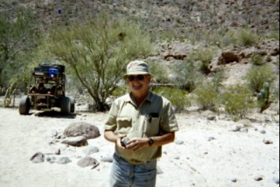
April, 2004:

Here see great amounts of super hot water flow out and go about 400 feet to where it merges with the cool mountain stream. HOT SPRING GPS: 30º38.85',
115º12.41', elev. 2,041'

Jide is by a hot water tub built where the spring water flows down from the terrace, then heads downstream. The water was too hot in the tub. Photo
looking south.

Photo looking north/ downstream. Here is the tub just below the spring, but the water is a scalding 140ºF! We go over 300 feet downstream and make a
tub where the temperature is closer 105ºF.

I climb high up the canyon for an 'almost aerial' photo (looking south) of the hot springs and hot stream, along right edge of arroyo. Beyond, at the
next bend is a lone blue palm tree.
This barrel cactus in the is about 7 feet tall. I stood next to it and it was over a foot taller than me. You just never know what wonders you will
find in Baja!
SKY VIEW (Thanks to Baja Lou!)

Photo looking eastward, down stream. Shown (going upstream) is: the end of the 4WD road, a former cilantro* farm area, hot springs, and a palm tree
location. (*or other cash crop)
|
|
|
David K
Honored Nomad
Posts: 64480
Registered: 8-30-2002
Location: San Diego County
Member Is Offline
Mood: Have Baja Fever
|
|
After the big rains of Jan. 2010... Has anyone been back in?
There was some effort to develop the hot springs and pipe the thermal water to palapas a couple years ago reported by bajalou... the road was also
re-opened to the springs... It had been open many years ago per Barry A., but in 2001 & 2004 the last mile was by foot only... rocks and bushes
prevented anything wider than a burro from getting through.
Flash floods will constantly change the canyon floor and there may be no way to ever make a camp ground in there. The hot springs are not much higher
than the bench where the marijuana was grown and I would guess would be where a campground could be built. So, unlike Guadalupe Canyon with a spring
higher than the camps... the lack of pressure to move the water may be an issue.
|
|
|
BajaRob
Senior Nomad
Posts: 722
Registered: 9-15-2003
Location: Bahia Santa Maria y Newport Or
Member Is Offline
Mood: Life is good
|
|
David
We hiked in last Spring. Atvs can make it. We decided to camp at Canon Cajon. Can't wait to go back.
|
|
|
David K
Honored Nomad
Posts: 64480
Registered: 8-30-2002
Location: San Diego County
Member Is Offline
Mood: Have Baja Fever
|
|
| Quote: | Originally posted by BajaRob
We hiked in last Spring. Atvs can make it. We decided to camp at Canon Cajon. Can't wait to go back. |
Can you describe what was there... or what was added since 2004? Any problem entering the canyon... for a while they said a fence blocked the road at
the mouth? Any photos (I can post)?
|
|
|
Barry A.
Select Nomad
Posts: 10007
Registered: 11-30-2003
Location: Redding, Northern CA
Member Is Offline
Mood: optimistic
|
|
I agree on the building of any campgrounds, David----very problamatic. The only "high" benches within that canyon below the hot springs were quite a
bit further down canyon than the MJ garden bench, as I recall. There has always been ample evidence of HUGE flooding in that canyon, and it happens
quite often.
When my son and I camped at the Hot Springs in Oct. of 1996 the road in, tho a 4x4 road, was really quite good. (we went in with a Toyota FJ-40 and a
Isuzu Trooper). We camped there several nights, and one night late a pickup came in, probably to check us out. The two occupants got out and started
walking towards our camp but my son's German Shepard scared them away fast. They got back in their truck and sped away in a hurry, with loud Mexican
music playing on their radio thruout their visit. At the time I thought that wierd, not knowing about the "gardens" just down canyon. When you told
me later about the "garden" it all made sense to us.
That canyon was apparently one of the approaches to the San Pedro Martir Mission (as one of your maps indicates), and there is still some evidence of
a "trail", but not much. Edward "Bud" Bernhard hiked the "trail" from the Hot Spring up to the Mission, he told me, back in the early '60's, as I
recall. Bud passed away several years ago, in Coronado. I am not sure, but NOMAD "Vince" may have additional info on Bud's wanderings in that
area--------Bud covered a lot of ground over the '50's and '60's, probably more than any other person that I know of. My first visit to the canyon
was in the very early '60's with Bud, Myron Smith, my daughter and "then" wife, and many others on a "quasi" Sierra Club expedition.
Beautiful and wild country.
Thanks for the great comprehensive maps and pics, and explanations.
Barry
|
|
|
David K
Honored Nomad
Posts: 64480
Registered: 8-30-2002
Location: San Diego County
Member Is Offline
Mood: Have Baja Fever
|
|
Thanks Barry... of interest, I have kept your detailed emails to me of your trip there (and othe off beat Baja places)... I could post and preserve it
with others, should my email crash?!
|
|
|
BajaRob
Senior Nomad
Posts: 722
Registered: 9-15-2003
Location: Bahia Santa Maria y Newport Or
Member Is Offline
Mood: Life is good
|
|
the corral on the north side high ground was still there. No active cilantro farming observed. The huge water flow created major boulder fields.
Possible camp site this Spring??
|
|
|
David K
Honored Nomad
Posts: 64480
Registered: 8-30-2002
Location: San Diego County
Member Is Offline
Mood: Have Baja Fever
|
|
| Quote: | Originally posted by BajaRob
the corral on the north side high ground was still there. No active cilantro farming observed. The huge water flow created major boulder fields.
Possible camp site this Spring?? |
Shall we bring picks and shovels to make hot tubs? Maybe some drip tube to bring over some cool mountain water from the nearby stream....? Camping
with hot and cold running water!
|
|
|
BajaRob
Senior Nomad
Posts: 722
Registered: 9-15-2003
Location: Bahia Santa Maria y Newport Or
Member Is Offline
Mood: Life is good
|
|
H & C water camping works for us. Let's talk up a Nomad camp out in Valle Chico with day trips to Caliente, Cajon, Diablo, etc.
|
|
|
BajaRob
Senior Nomad
Posts: 722
Registered: 9-15-2003
Location: Bahia Santa Maria y Newport Or
Member Is Offline
Mood: Life is good
|
|
[Edited on 1-9-2011 by BajaRob]
|
|
|
Barry A.
Select Nomad
Posts: 10007
Registered: 11-30-2003
Location: Redding, Northern CA
Member Is Offline
Mood: optimistic
|
|
| Quote: | Originally posted by David K
Thanks Barry... of interest, I have kept your detailed emails to me of your trip there (and othe off beat Baja places)... I could post and preserve it
with others, should my email crash?! |
Oh oh----------the "fact checkers" might have a fun-time comparing what I wrote "back then" and what I write now-------
-----the ol memory banks are fading a little, and I may have changed things around over the years---- you know------to make the story more "readable"
and "entertaining"?????  
Those "corrals" that BajaRob speaks of (I think it was BRob) are where we camped after raking away all the "droppings"-----it was the only place that
looked "safe" from the floods.
Barry 
(edited to add the "corral" story)
[Edited on 1-9-2011 by Barry A.]
|
|
|
David K
Honored Nomad
Posts: 64480
Registered: 8-30-2002
Location: San Diego County
Member Is Offline
Mood: Have Baja Fever
|
|
| Quote: | Originally posted by BajaRob
H & C water camping works for us. Let's talk up a Nomad camp out in Valle Chico with day trips to Caliente, Cajon, Diablo, etc.
|
When I met bajalou and his friends as well as Mexitron, Pappy and Taco de Baja, ... in Valle Chico's Parral Canyon.
We also explored Berrendo, Carrizo, Agua Caliente and Cajon Canyon that trip: http://vivabaja.com/404
|
|
|
David K
Honored Nomad
Posts: 64480
Registered: 8-30-2002
Location: San Diego County
Member Is Offline
Mood: Have Baja Fever
|
|
April, 2004
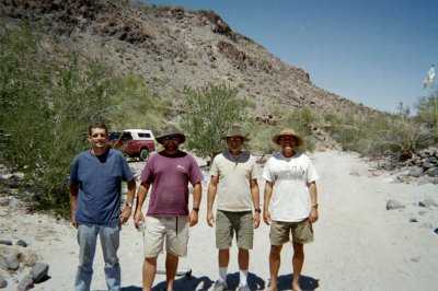
Following their four days backpacing to Baja's most remote mission (San Pedro Martir), with Jack Swords, is (L to R) Taco de Baja, Huddo, Mexitron,
and Pappy who met us at Parral's entrance gate.
Also at the Parral gate was the gang from El Dorado Ranch, led by Baja Lou. The San Pedro Martir group headed down to Matomi Canyon to camp. The rest
of us went up to the big corral, 3.0 miles from the gate at 30°30.64', 115°06.48'.
|
|
|


