| Pages:
1
2
3
..
5 |
micah202
Super Nomad

Posts: 1615
Registered: 1-19-2011
Location: vancouver,BC
Member Is Offline
|
|
the HOTSPRING thread
It'd be nice to have hotspring information in one easy thread!
...maybe those who have been to various locations can leave directions for others,,,or drop a link to another thread for a given spring!
In various searches ,I've found mention to hotsprings at
....gaudalupe
,,,,,san felipe
,,,,south of Ensenada
,,,,,between La Paz and Cabo
.........any others in Baja??
[Edited on 11-25-2015 by micah202]
|
|
|
mcfez
Elite Nomad
Posts: 8678
Registered: 12-2-2009
Location: aka BN yankeeirishman
Member Is Offline
|
|
puertecitos hot springs
Right next to the ocean, at high tide the springs are completely submerged. As the tide recedes pools of various temperatures are created. Eventually
the springs will get too hot and you have to wait for the tide again. $5 per car per day (or pending the gate keeper's mood!), or free if you live in
the area.

Old people are like the old cars, made of some tough stuff. May show a little rust, but good as gold on the inside.
|
|
|
micah202
Super Nomad
Posts: 1615
Registered: 1-19-2011
Location: vancouver,BC
Member Is Offline
|
|
| Quote: | Originally posted by mcfez
Right next to the ocean, at high tide the springs are completely submerged. As the tide recedes pools of various temperatures are created. Eventually
the springs will get too hot and you have to wait for the tide again. $5 per car per day (or pending the gate keeper's mood!), or free if you live in
the area. |
that sounds like the one I listed as SanFelipe--the 'gatekeeper' funny gal who's property adjoins?
....do you have a link handy for inf on it?
|
|
|
mcfez
Elite Nomad
Posts: 8678
Registered: 12-2-2009
Location: aka BN yankeeirishman
Member Is Offline
|
|
Some folks thinks this place is in SF....it's not:
Puertecitos (GPS coordinates 30'92 N ~ 114'70 W)
The highway to Puertecitos is now a smooth run, being rebuilt this past year. Takes a hour to get there from SF
Puertecitos has a boat ramp, decent campground, tight security. Look in the search link here on this page (above)...you find a very detail account of
this place that I wrote about 6 months ago.
Puertecitos has a reputation....never mind the rumors.
Old people are like the old cars, made of some tough stuff. May show a little rust, but good as gold on the inside.
|
|
|
David K
Honored Nomad
Posts: 64476
Registered: 8-30-2002
Location: San Diego County
Member Is Offline
Mood: Have Baja Fever
|
|
PUERTECITOS
Located about 55 highway miles south of San Felipe...
The hot springs are located between the high and low tide lines on the far (or gulf side) of the point that creates the cove of Puertecitos. Each day,
the springs are flushed with fresh sea water. Ideal soaking time is after the high tide has dropped below the pools. The mix with sea water makes the
temperature acceptable. The springs do emit a strong sulfur odor.
In the photo taken from the old road just south of town looking northeast, the springs are just over the low spot in the hill on the point across the
cove:

Since the springs are in the Federal Zone, they are public... but unless you get there by boat... the land owner has charged an access fee (beginning
in 1992).
|
|
|
David K
Honored Nomad
Posts: 64476
Registered: 8-30-2002
Location: San Diego County
Member Is Offline
Mood: Have Baja Fever
|
|
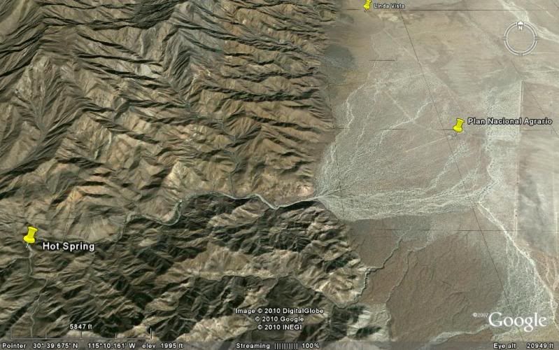
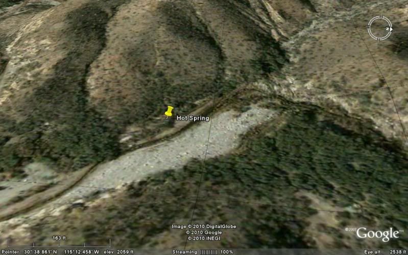
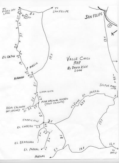
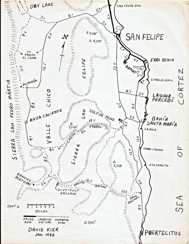
AGUA CALIENTE/ VALLE CHICO
As most hot springs in Mexico seem to be named 'Agua Caliente', I added the region with the name.
Valle Chico is located at the foot of the Sierra San Pedro Martir range, southwest of San Felipe. Many canyons drain into Valle Chico and one canyon
is named Agua Caliente because it contains a large hot spring.
So much water flows from this spring that it creates a hot steaming stream that runs for several hundred feet before merging with the cool mountain
stream in the middle of the canyon... Hot and cold running water in Baja!
The temperature has been measured at 140ºF, so bathing is only possible down the stream a ways unless the cool stream water could be mixed in the tub
that was built just below the spring. Perhaps bring a roll of drip irrigation tube to stretch to the tub from the stream?
2001:

Hot Spring location in Agua Caliente Canyon. Photo looking north, down the stream from where we came. The hot stream is to the left of the tub and
flows hot for a good distance before joining the cool stream.

Steaming streams on both sides of me! I am just below the source spring, located on a bench alongside of the canyon arroyo.
2004:

Here see great amounts of super hot water flow out and go about 400 feet to where it merges with the cool mountain stream. HOT SPRING GPS: 30°38.85',
115°12.41', elev. 2,041'
HOT WATER STREAM

Jide is by a hot water tub built where the spring water flows down from the terrace, then heads downstream. The water was too hot in the tub. Photo
looking south.

Photo looking north/ downstream. Here is the tub just below the spring, but the water is a scalding 140°F! We go over 300 feet downstream and make a
tub where the temperature is closer 105°F.

I climb high up the canyon for an 'almost aerial' photo (looking south) of the hot springs and hot stream, along right edge of arroyo. Beyond, at the
next bend is a lone blue palm tree.
This barrel cactus in the is about 7 feet tall. I stood next to it and it was over a foot taller than me. You just never know what wonders you will
find in Baja!
SKY VIEW (Thanks to Baja Lou!)

Photo looking eastward, down stream. Shown (going upstream) is: the end of the 4WD road, a former cilantro* farm area, hot springs, and a palm tree
location. (*or other cash crop)
Spring location from satellite views:
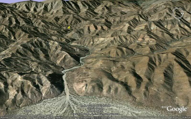
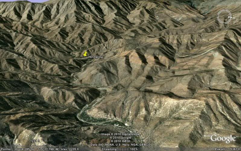
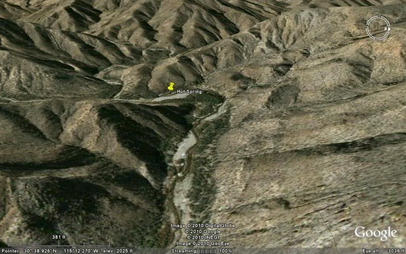
Maps:
2004:
1988:
[Edited on 1-22-2011 by David K]
|
|
|
bajaguy
Elite Nomad
Posts: 9247
Registered: 9-16-2003
Location: Carson City, NV/Ensenada - Baja Country Club
Member Is Offline
Mood: must be 5 O'clock somewhere in Baja
|
|
Hey, Fez
What's the status on the PEMEX station in Puertecitos???
|
|
|
bajaguy
Elite Nomad
Posts: 9247
Registered: 9-16-2003
Location: Carson City, NV/Ensenada - Baja Country Club
Member Is Offline
Mood: must be 5 O'clock somewhere in Baja
|
|
San Carlos
Hot springs in Canyon San Carlos, Ensenada.
Take Highway 1 headed south from Ensenada. About 4 miles south of the COSTCO, turn left at the road to the Baja Country Club (stoplight intersection).
Follow signs to the Country Club, then turn left off the Country Club road where indicated by the sign for the hot springs.......
I have been told that you can make it to the hot springs in a passenger car, but since you have to cross a stream bed with running water several
times, I would suggest something with high ground clearance.
I'm sure other Nomads can fill in the details and add photos
[Edited on 1-22-2011 by bajaguy]
|
|
|
micah202
Super Nomad
Posts: 1615
Registered: 1-19-2011
Location: vancouver,BC
Member Is Offline
|
|
| Quote: | Originally posted by mcfez
Some folks thinks this place is in SF....it's not:
Puertecitos (GPS coordinates 30'92 N ~ 114'70 W)
The highway to Puertecitos is now a smooth run, being rebuilt this past year. Takes a hour to get there from SF
Puertecitos has a boat ramp, decent campground, tight security. Look in the search link here on this page (above)...you find a very detail account of
this place that I wrote about 6 months ago.
Puertecitos has a reputation....never mind the rumors. |
....good'thear the road's paved--is that right through to Hwy1 in the south yet??,,,,,I went that route ~20 years ago--peurtecitos 'highway' they
called it--quite an adventure,,glad those locals came along when I got stuck--wouldn't even accept a donation for their help!!
|
|
|
micah202
Super Nomad
Posts: 1615
Registered: 1-19-2011
Location: vancouver,BC
Member Is Offline
|
|
....gaudalupe
,,,,,peurtecitos area
,,,,south of Ensenada-Canyon San Carlos
,,,,,between La Paz and Cabo
.....any others??
|
|
|
mcfez
Elite Nomad
Posts: 8678
Registered: 12-2-2009
Location: aka BN yankeeirishman
Member Is Offline
|
|
| Quote: | Originally posted by bajaguy
What's the status on the PEMEX station in Puertecitos??? |
Go to the station. It'll be chained mostly (again). Go around the back of the building and look for the attendant. If not there, go to Campos
Puertecitos entrance (300 ft away) and tell then you like to have some gas.
Getting to and back from Puertecitos from San Felipe....fill up in San Felipe and you'll have plenty of extra to get back to SF.
Getting to Gonzaga Bay from San Felipe....fill up in San Felipe and you'll have make it there with ease.
Puertecitos gas station is no longer a real thing to need.....with the new pavement
[Edited on 1-22-2011 by mcfez]
Old people are like the old cars, made of some tough stuff. May show a little rust, but good as gold on the inside.
|
|
|
David K
Honored Nomad
Posts: 64476
Registered: 8-30-2002
Location: San Diego County
Member Is Offline
Mood: Have Baja Fever
|
|
| Quote: | Originally posted by micah202
....gaudalupe
,,,,,peurtecitos area
,,,,south of Ensenada-Canyon San Carlos
,,,,,between La Paz and Cabo
.....any others?? |
It is Guadalupe Canyon Hot Springs, southwest of Mexicali (as there are other Guadalupes in Baja. There is also a hot spring in Valle de Guadalupe
(the wine growing area along Hwy. 3).
It is 'Puertecitos'
|
|
|
micah202
Super Nomad
Posts: 1615
Registered: 1-19-2011
Location: vancouver,BC
Member Is Offline
|
|
| Quote: | Originally posted by David K
| Quote: | Originally posted by micah202
....gaudalupe
,,,,,peurtecitos area
,,,,south of Ensenada-Canyon San Carlos
,,,,,between La Paz and Cabo
.....any others?? |
....... There is also a hot spring in Valle de Guadalupe (the wine growing area along Hwy. 3). |
...north of ensenada??...do you have the directions for that one??
..Anything between El Rosario and LaPaz??
|
|
|
Trueheart
Nomad
Posts: 155
Registered: 1-31-2010
Member Is Offline
|
|
David K:
Your comments, pictoral, and maps come with great detail. Awesome!
Thank you for the effort.
Steve
|
|
|
David K
Honored Nomad
Posts: 64476
Registered: 8-30-2002
Location: San Diego County
Member Is Offline
Mood: Have Baja Fever
|
|
De nada Steve!
micah: Yes... when I have time I will make a map of the hot springs I know about... in brief, others: San Antionio Hot Springs off Hwy. 3 to San
Felipe, Ojos Negros (north of), San Borja, El Coloradito (in the sand), Punta Banda (in the sand), Bahia Concepcion (several), San Cosme (Agua Verde),
Agua Caliente (Santiago)... etc.
|
|
|
micah202
Super Nomad
Posts: 1615
Registered: 1-19-2011
Location: vancouver,BC
Member Is Offline
|
|
| Quote: | Originally posted by David K
De nada Steve!
micah: Yes... when I have time I will make a map of the hot springs I know about... in brief, others: San Antionio Hot Springs off Hwy. 3 to San
Felipe, Ojos Negros (north of), San Borja, El Coloradito (in the sand), Punta Banda (in the sand), Bahia Concepcion (several), San Cosme (Agua Verde),
Agua Caliente (Santiago)... etc. |
....thank-you!...I had no idea there's springs around bahia conception,,I've been there a few times over the years.
......I'm looking forward to hearing some details when you're able!
.
[Edited on 1-23-2011 by micah202]
|
|
|
David K
Honored Nomad
Posts: 64476
Registered: 8-30-2002
Location: San Diego County
Member Is Offline
Mood: Have Baja Fever
|
|
Yup, at Santisapc, El Coyote, more... all at or near sea level... Other Nomads can tell you better as I have not been in any of them... but I will
give you what I have...
|
|
|
coho
Junior Nomad
Posts: 43
Registered: 5-6-2009
Location: bahia concepcion
Member Is Offline
|
|
concepcion bay hot springs
Indeed...thermal hot springs at Posada Concepcion on Concepcion bay. Just south of Santispac...At sea level and right at the water's edge. Although
Posada is a private gated community of 64 homes right off Hwy 1, RV sites are available at $19 per night with full hookups, and rental casita is
available at $50 per night and overnight rentals include use of the hot springs. In addition another beach front hot spring is to be found at the
northern beach at Posada that is usable at certain tide heights and is available to the public. A circle of rocks at water's edge that captures the
hot water and mixes with the salt water of the bay makes for an unforgetable experience for hot spring aficionados. 12 miles south of Mulege watch
for the signs from either direction. Check out the photos at: http://www.posadaconcepcion.net/amenities.html
|
|
|
bajafam
Senior Nomad
Posts: 654
Registered: 9-6-2009
Location: Northeast AZ, Bahia Asuncion, BCS :)
Member Is Offline
Mood: DLTBGYD
|
|
The only one we've actually been to is Uruapan Hot Springs, which is located about two miles off the highway S. of Ensenada before you get to Santo
Tomas, there is a sign, but it's very easy to miss. It's mostly a laundromat, but there are bathtubs and the proprietress is very kind and will tour
you to where the spring bubbles out of the ground.
We have a book, Hot Springs and Hot Pools of the Southwest, that highlights some of the springs in Baja. Some that have not been mentioned:
Palomar Canyon Hot Springs ~ SW of Mexicali, 45 miles from the nearest paved road.
Russian Valley Hot Springs ~ S. of Tecate, 50 miles off of Hwy. 3 (which is what I think David was referring to as San Antonio).
Cantu Hot Springs ~ S. of Punta Banda.
Rancho Gilberto/ St. Tomas Hot Springs, apparently 4.1 miles down the road to La Bocana.
Marconi Warm Springs ~ Ojos Negros Valley, Hwy 3 east of Ensenada for 30 miles, turn left at sign to Ojos Negros. 12 miles to springs.
Agua Caliente Hot Springs ~ E. of Ensenada, E on Hwy 3 to K26, turn right at Agua Caliente sign and follow 5 mile dirt road to resort.
Valle de Trinidad/Rancho Los Pozitos ~ SW of Ensenada, E from Ensenada on Hwy 3 for 60 miles, 1 mile turn right onto dirt road at church, 2 miles
toward west end of valley and follow dirt road about 5 miles...look for Rancho Los Pozitos, Familia Arballo.
Mulege Mission Warm Springs ~ park at mission and walk downhill, cross stream in front of dam, continue 100 yards downstream; gas bubbles can be seen
rising from stream.
Santispac ~ drive to far right side of cove, walk approx. 100 yards on a dirt trail around the mangrove swamp to the two pools.
Concepcion Beach ~ there are steep cliffs that border this beach, therefore, hike south along the tide pools from Santispac or north from Los Cocos
Beach.
El Coyote Beach ~ park at campground, follow rocky trail 100 yards to pool.
Hotel Buena Vista, La Paz ~
Remember, we have only been to Uruapan, so the rest of the info is from a book and we are not responsible for any incorrect info....blame them!!!
|
|
|
Bajaboy
Ultra Nomad
Posts: 4375
Registered: 10-9-2003
Location: Bahia Asuncion, BCS, Mexico
Member Is Offline
|
|
| Quote: | Originally posted by bajafam
The only one we've actually been to is Uruapan Hot Springs, which is located about two miles off the highway S. of Ensenada before you get to Santo
Tomas, there is a sign, but it's very easy to miss. It's mostly a laundromat, but there are bathtubs and the proprietress is very kind and will tour
you to where the spring bubbles out of the ground.
We have a book, Hot Springs and Hot Pools of the Southwest, that highlights some of the springs in Baja. Some that have not been mentioned:
Palomar Canyon Hot Springs ~ SW of Mexicali, 45 miles from the nearest paved road.
Russian Valley Hot Springs ~ S. of Tecate, 50 miles off of Hwy. 3 (which is what I think David was referring to as San Antonio).
Cantu Hot Springs ~ S. of Punta Banda.
Rancho Gilberto/ St. Tomas Hot Springs, apparently 4.1 miles down the road to La Bocana.
Marconi Warm Springs ~ Ojos Negros Valley, Hwy 3 east of Ensenada for 30 miles, turn left at sign to Ojos Negros. 12 miles to springs.
Agua Caliente Hot Springs ~ E. of Ensenada, E on Hwy 3 to K26, turn right at Agua Caliente sign and follow 5 mile dirt road to resort.
Valle de Trinidad/Rancho Los Pozitos ~ SW of Ensenada, E from Ensenada on Hwy 3 for 60 miles, 1 mile turn right onto dirt road at church, 2 miles
toward west end of valley and follow dirt road about 5 miles...look for Rancho Los Pozitos, Familia Arballo.
Mulege Mission Warm Springs ~ park at mission and walk downhill, cross stream in front of dam, continue 100 yards downstream; gas bubbles can be seen
rising from stream.
Santispac ~ drive to far right side of cove, walk approx. 100 yards on a dirt trail around the mangrove swamp to the two pools.
Concepcion Beach ~ there are steep cliffs that border this beach, therefore, hike south along the tide pools from Santispac or north from Los Cocos
Beach.
El Coyote Beach ~ park at campground, follow rocky trail 100 yards to pool.
Hotel Buena Vista, La Paz ~
Remember, we have only been to Uruapan, so the rest of the info is from a book and we are not responsible for any incorrect info....blame them!!!
|
Hotel Buena Vista is located on the East Cape. Stayed there and all the hot water comes from the hot springs. Nice place when we were there a long
time ago.
|
|
|
| Pages:
1
2
3
..
5 |
|


