| Pages:
1
2
3
..
6 |
David K
Honored Nomad

Posts: 64480
Registered: 8-30-2002
Location: San Diego County
Member Is Offline
Mood: Have Baja Fever
|
|
HWY. 1, 3, 5, 19 + KILOMETER MARKERS: Share Yours!
The kilometer markers offer a convenient way to note places or side roads along the highway.
The markers re-zero every so often...
In Baja Norte: Tijuana, Ensenada, San Quintin (south), L.A. Bay Jcn. (Parador Punta Prieta), Eagle Monument/ State Border. The numbers increase as you
drive south.
In Baja Sur: Santa Rosalia, Loreto, Villa Insurgentes, La Paz, Cabo San Lucas. The number decrease as you drive south.
I have several... and please add yours... I will try and re-organize them from north to south when everyone has had a chance to contribute...
There was a change to the markers south of San Quintin a few years ago that added 2-3 km. to the old ones.
I have a lot, and they are scattered through my notebooks and web pages... So give me a couple days to add to and edit the following list:
EDIT: The large list is posted here, from the end of this thread:
TW & David K's KM marker notes... Please add yours!
TW has the biggest list, and here I combined his with those I have:
Kilometer numbers for Hwy 1:
KM 0 TJ
KM 36 Rene's Restaurant before old toll gate
KM 52 Cantamar sand dunes
KM 60 Half Way house restaurant
KM 70 Beach area past La Fonda
KM 74 La Salina (harbor, marina, and cantina)
KM 78 Bajamar/ Jatay
KM 84 Overlook
KM 99 Last Toll Gate
KM 105 Jct with Hwy 3 from Tecate
Reset Kilometer to 0 at Ensenada:
KM 42 Uruapan
KM 50 Santo Tomas
KM 77/78 Paved road to Erendira
KM 102/103 Graded road to Valle de Trinidad
KM 140 Paved road to National Park and Observatory
KM 157 Camalu
KM 169 Access to Bahia San Ramon
KM 191/192 Several Hotels both sides.
Reset Kilometer 196/0 South of San Quintin:
KM 1 Old Mill
KM 3 Old Pier
KM 11 Los Pinos Pemex, paved road west to Hotel Mision Santa Maria and Motel Cielito Lindo
KM 16 Access east to Baja 1000 course
KM 57 El Rosario Pemex
KM 80 & 81 Access to Puerto San Carlos
KM 103 Access to San Juan de Dios and old road back to El Rosario
KM 106 El Arenoso
KM 116 Hector's Monument
KM 121 El Progresso/ Mission San Fernando
KM 132 Guayaquil, access to Puerto Catarina
KM 145 San Agustin
KM 146 Access to Puerto Catarina, joins road from KM132 above
KM 148 El Mármol access (9 miles)
KM 149 Sonora Café
KM 160 Agua Dulce access, (2 miles: go left 1.4 mi. to old main road, turn north for .3 mi. then turn right for .3 more.)
KM 168 Access to Pacific Coast & Baja 1000 route & San Telmo Onyx mine, mine turnoff left at 10.7 mi. in
KM 176 Rock Art parking
KM 179 Cataviña
KM 181 Rancho Santa Ynez
KM 209/210 El Pedregoso Rock mtn west side
KM 213 Access east to Turquesa Canyon Grade
KM 233 Jct Hwy 5 from Cocos (12.7 mi.) and Gonzaga Bay (35 mi.)
KM 234 Access west to Pacific Ocean at Playa Christie
KM 251 Access to Baja 1000 race course and Rd to Mission Calamajue (5.4 mi., 13.8 to mission)
KM 252 Access to Pacific at Bahia Blanco
KM 261 El Crucero, Calamajué Canyon road (15.3 miles to mission, 28.0 to Coco's, 50.3 mi. to Gonzaga Bay)
KM 270 Access SE to El Desengaño gold mine (AB), NE to Rancho San Luis.
KM 271 Access to Pacific Ocean joins Rd from KM252 in about 8 miles
KM 282/0 Jcn Hwy to LA Bay
On L.A. Bay Hwy:
KM 45 San Borja access
KM 65/66 L.A. Bay
On Hwy. 1, at L.A. Bay Jcn.: Reset Kilometer to 282/0:
KM 14 Punta Prieta
KM 39 Hwy to Santa Rosalillita
KM 53 Rosarito and access to Mission San Borja
KM 62/63 Access to Pacific Ocean by Altamira (AB)
KM 67/68 Access to El Tomatal and Miller's Landing
KM 70 Access east to El Marmolito Onyx mine
KM 95 Villa Jesus Maria
Reset Kilometer to 0/224 at Eagle Monument and note KMs get smaller going south, now in Baja Ca Sur:
KM 220 Guerrero Negro
KM 208 Access west to whale watching
KM 189 Jct hwy to El Arco
KM 154 Las Palomas/ Guillermo Prieto/ Santa Gertrudis/ San Francisquito access
KM 144 Vizcaino
KM 133 Access to old Baja 1000 course east side north bound
KM 124 Microwave tower Los Angeles
KM 118 Jct Road to San Francisco de la Sierra
KM 98 Jct Hwy to Punta Abreojos
KM 88 Microwave tower Abulon
KM 74 San Ignacio
KM 35 Microwave tower Caguama
KM 33 Jct Geo plant Tres Virgenes
KM 17/18 Microwave tower Almeja
KM 0 Santa Rosalia
Reset Kilometer to 0/197 at Santa Rosalia:
KM 189/190 Prison
KM 180 Microwave tower San Lucas
KM 168/169 San Jose de Magdalena access
KM 162/163 Boca de Magdalena access
KM 156 Palo Blanco/ Punta Chivato access
KM 133/134 Mulegé
KM 120 Villas de Mulegé
KM 118 Playa Frambes Resort access
KM 76 Access to east side of Bahia Concepcion. Note on one map it's KM74
KM 60 Jct road west to San Isidro and La Purisima
KM 30 San Juan Bautista Londó access
KM 0 Loreto
Reset Kilometer KM0/120 at Loreto:
KM 94 Puerto Escondido
KM 84/85 Ligui
KM 71 Microwave tower Ligui
KM 63 Jct Road to Agua Verde
KM 0 Ciudad Insurgentes, left turn for south
Reset Kilometer KM0/234 at turn in Insurgentes:
KM 210 Ciudad Constitución
KM 195/196 Jct Graded road east to Mission San Luis Gonzaga
KM 180 Access road west to Puerto Cancun
KM 173/174 Graded road west to Puerto Cancun
KM 169/170 Microwave tower el Torote
KM 157 Santa Rita and graded road west to Puerto Chale
KM 154 Road east to San Andres and beyond
KM 135 Microwave tower el Rifle
KM 128 Road west to El Estero joins road from KM110 Las Pocitas
KM 110 Las Pocitas east to San Evaristo & west to Santa Fe, joins KM128 rd
KM 82 Microwave tower el Coyote
KM 80/81 road west to Punta Conejo
KM 60 Microwave tower el Cardón
KM 56 road to Punta Marquez
KM 38 Access road to pacific at San Isidro
KM 36 Microwave tower Matape and access road to Pacific at Los Inocentes
=================================================
HWY 3 (Ensenada to San Felipe):
KM 19 Access to the Wall on race course.
KM 33 SCORE race course return route.
KM 39 Ojos Negros turn off.
KM 55 Laguna Hanson turn off.
KM 86 El Alamo.
KM 90 Independencia.
KM 108 The Summit access as well as Nuevo Jct.
KM 117 Goat Trail.
KM 120 Valle de Trinidad.
KM 130 Children Orphanage, Malcom Smith supports it.
KM 137/138 Mike Sky Rancho access (20 mi.).
KM 153 Access to Arroyo Grande.
KM 155 Access to Diablo Dry Lake thru arroyo.
KM 165 Access to Diablo Dry Lake by graded road.
KM 173 Access to Borrego pit area.
KM 179/180 Borrego crossing for races.
KM 197 Jct with hwy 5 KM141.
HWY 5:
KM 40 Access to Laguna Salada thru mtns.
KM 49 Access to Laguna Salada east side.
KM 87 Saldana I and Tres Pozos.
KM 89 Saldana II and access to Arroyo Grande wells.
KM 105 La Ventana.
KM 107 Access thru mtn to Arroyo Grande wells.
KM 123 Gold mine road.
KM 133 Access to race courses.
KM 141 Jct with hwy 3 KM197.
KM 142 Three Poles.
KM 149 Race course access.
KM 159 Race course access.
KM 168 Race course access.
KM 179 Zoo Road.
KM 188 San Felipe Arches.
South of San Felipe:
KM 0 Airport access
KM 20/21 Rancho Percebu access
KM 26 Shell Island access (1.9 mi.)
KM 31 Bahia Santa Maria access
KM 32 Nuevo Mazatlan/El Sahuaro access
KM 35 Colonia Delicias
KM 49 El Coloradito access
KM 52 Old Puertecitos Rd, race course.
KM 54 Campo Cristina access
KM 58/59 Los Olivos access
KM 60/61 Matomi wash at San Rafael.
KM 72 Playa Destiny
KM 74/75 Puertecitos access
KM 83 Bahia Cristina
KM 84.5 La Costilla
KM 99 Paved Pullout/Viewpoint
KM. markers were changed south of here in 2016...
KM 124 Campo Delfines (1 km. south of pavement end in July 2012).
KM 133 Punta Bufeo road
KM 143 Papa Fernandez' road
KM 145 Military Checkpoint
KM 147 Gonzaga Pemex/ Alfonsina's road/ Rancho Grande
KM 155 Arroyo Santa MarÃa bridge
KM 159 Las Palmitas road
KM 167.5 END OF PAVEMENT (July 2016)
2023 Edit: The most recent updated Km. guide is on this page: https://vivabaja.com/kilometer-guide/
[Edited on 5-4-2023 by David K]
|
|
|
Oggie
Nomad
Posts: 312
Registered: 6-16-2009
Location: Carlsbad, CA/BOLA
Member Is Offline
Mood: Missing Baja
|
|
Almost to BOLA
A man never stands as tall as when he kneels to help a child.
Knights of Pythagoras
Funny how falling feels like flying
for a little while - Bad Blake
|
|
|
bajaguy
Elite Nomad
Posts: 9247
Registered: 9-16-2003
Location: Carson City, NV/Ensenada - Baja Country Club
Member Is Offline
Mood: must be 5 O'clock somewhere in Baja
|
|
In the real world
They start at one end of the state/highway and go to the other without re-zeroing.........that way you can tell where you are............
But we are not in the "real world"............
Your mileage may vary.........
|
|
|
BajaBlanca
Select Nomad
Posts: 13165
Registered: 10-28-2008
Location: La Bocana, BCS
Member Is Offline
|
|
KM 98 - exit to Blanca and Les's house

heading south between Vizcaino and San Ignacio
|
|
|
Russ
Elite Nomad
Posts: 6741
Registered: 7-4-2004
Location: Punta Chivato
Member Is Offline
|
|
KM 156 at Palo Verde (To Punta Chivato)
Bahia Concepcion where life starts...given a chance!
|
|
|
ddawson
Nomad
Posts: 103
Registered: 9-6-2010
Location: Hilo
Member Is Offline
|
|
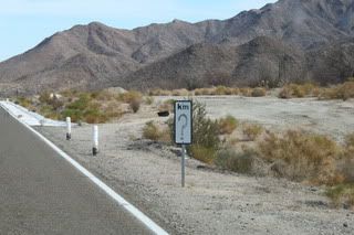
My new fave marker KM 96 South of El Rosario, taken Fri 1/21:

|
|
|
Bajahowodd
Elite Nomad
Posts: 9274
Registered: 12-15-2008
Location: Disneyland Adjacent and anywhere in Baja
Member Is Offline
|
|
So, my question is why the renumbering? Maybe I could understand if each state had their own numbering system. That would only make two systems.
Inasmuch as they regularly post mileage (kilometer) signs telling you how far it is to places that lie ahead, even when in somecases it get a little
ridiculous (distance to TJ outside of Mulege, for instance), I would think that since Mex 1 is "the" transpenisular highway, it would make some sense
that they numbered it consecutively from top to bttom or vice versa.
|
|
|
David K
Honored Nomad
Posts: 64480
Registered: 8-30-2002
Location: San Diego County
Member Is Offline
Mood: Have Baja Fever
|
|
Good question... Remember seperate road crews worked on the highway completion (~1968-Dec. 1, 1973)... most work was done in 1973 in a rush to
complete before the president's term ended.
The most progress was done in Baja Sur heading north... Baja Sur was a federal territory then, if that mattered.
During 1972:
North to South crews started near Colonet and advanced to San Quintin by 1973.
South to north crews had built and paved the road from Insurgentes over to Loreto and north to Santa Rosalia... and were partway to San Ignacio by
1973.
In 1973:
By July, 1973 the north crew had paved past El Rosario to the El Progreso/Mision San Fernando rd. and a road bed was completed to near Agua Dulce
(past San Agustin).
The south crew had paved past San Ignacio, to Guerrero Negro, Villa Jesus Maria, and in sections to Punta Prieta! Roadbed work was completed to Laguna
Chapala.
The north and south bound construction crews met at San Ignacito (just south of Santa Ynez, near the site of what would become Cataviña after the
highway was built).
Pavement was completed in November... the opening cermony was heald at the newly erected Eagle Monument, near Guerrero Negro on Dec. 1, 1973.
|
|
|
BajaWarrior
Super Nomad
Posts: 2307
Registered: 9-27-2006
Location: Mission Bay, San Diego. Playa Hermosa, San Felipe.
Member Is Offline
Mood: Anxious to get south
|
|
One Kilometer from Hwy. 1 heading toward Punta Santo Tomas...

[Edited on 1-24-2011 by BajaWarrior]
Haven't had a bad trip yet....
|
|
|
David K
Honored Nomad
Posts: 64480
Registered: 8-30-2002
Location: San Diego County
Member Is Offline
Mood: Have Baja Fever
|
|
How about when the Km. post is a cactus!?
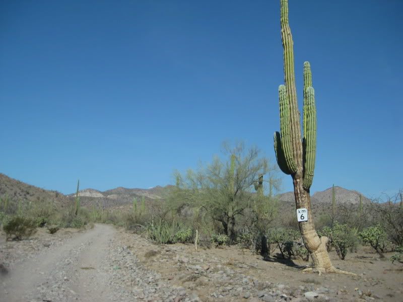
This is the San Borjitas road, west from Palo Verde (north of Mulege).
|
|
|
akbear
Nomad
Posts: 203
Registered: 8-23-2003
Location: Buena Vista BCS
Member Is Offline
|
|
km 108, just passed my drive way in Buena Vista, BCS.
|
|
|
BajaBlanca
Select Nomad
Posts: 13165
Registered: 10-28-2008
Location: La Bocana, BCS
Member Is Offline
|
|
I can't beleive they put the km marker on a cactus !! where is the biosphere protection agency when you need them ???!!!!
|
|
|
Bajahowodd
Elite Nomad
Posts: 9274
Registered: 12-15-2008
Location: Disneyland Adjacent and anywhere in Baja
Member Is Offline
|
|
| Quote: | Originally posted by David K
Good question... Remember seperate road crews worked on the highway completion (~1968-Dec. 1, 1973)... most work was done in 1973 in a rush to
complete before the president's term ended.
The most progress was done in Baja Sur heading north... Baja Sur was a federal territory then, if that mattered.
During 1972:
North to South crews started near Colonet and advanced to San Quintin by 1973.
South to north crews had built and paved the road from Insurgentes over to Loreto and north to Santa Rosalia... and were partway to San Ignacio by
1973.
In 1973:
By July, 1973 the north crew had paved past El Rosario to the El Progreso/Mision San Fernando rd. and a road bed was completed to near Agua Dulce
(past San Agustin).
The south crew had paved past San Ignacio, to Guerrero Negro, Villa Jesus Maria, and in sections to Punta Prieta! Roadbed work was completed to Laguna
Chapala.
The north and south bound construction crews met at San Ignacito (just south of Santa Ynez, near the site of what would become Cataviña after the
highway was built).
Pavement was completed in November... the opening cermony was heald at the newly erected Eagle Monument, near Guerrero Negro on Dec. 1, 1973.
|
I know that most Nomads have seen the ridculous situation where over and over, there are virtually duplicate road markers along the highway. Any
explanation for that? Often, they stand butting up against each other.
|
|
|
David K
Honored Nomad
Posts: 64480
Registered: 8-30-2002
Location: San Diego County
Member Is Offline
Mood: Have Baja Fever
|
|
Government make work project? Replace the old signs with new ones... only don't remove the old ones... 
Hey, back on topic... anyone have Km. marker notes? TW, I know you have some... ??
|
|
|
mcfez
Elite Nomad
Posts: 8678
Registered: 12-2-2009
Location: aka BN yankeeirishman
Member Is Offline
|
|
| Quote: | Originally posted by David K
I have a lot, and they are scattered through my notebooks and web pages... So give me a couple days to add to and edit the following list:
To Be Continued! |
Great freaking idea David! This master list will benefit me in my future travels trying to find off the beaten path turn offs.
Now...maybe someone can take those marker points and add directions "from point a to point b" to any significant spots of that area....
Example: Marker 123 is Pointe Final. Whats at that end of that dirt dirt there? Hope I am making sense...it's too early for me to be thinking!
Old people are like the old cars, made of some tough stuff. May show a little rust, but good as gold on the inside.
|
|
|
mcfez
Elite Nomad
Posts: 8678
Registered: 12-2-2009
Location: aka BN yankeeirishman
Member Is Offline
|
|
| Quote: | Originally posted by David K
Pointe = Punta |
Pointe = Punta = Punkt 
Old people are like the old cars, made of some tough stuff. May show a little rust, but good as gold on the inside.
|
|
|
bajacalifornian
Super Nomad
Posts: 1117
Registered: 9-4-2010
Location: Loreto/Lopez Mateos/Rosarito
Member Is Offline
|
|
Multiply by .6. Keeps me occupied and my brain trying to work.
|
|
|
David K
Honored Nomad
Posts: 64480
Registered: 8-30-2002
Location: San Diego County
Member Is Offline
Mood: Have Baja Fever
|
|
What's nice is they are every kilometer (or 6/10 of a mile), so just start looking for the turnoff as the numbers get close!
|
|
|
BajaGringo
Ultra Nomad
Posts: 3882
Registered: 8-24-2006
Location: La Chorera
Member Is Offline
Mood: Let's have a BBQ!
|
|

We are just about due west from where it all begins...

|
|
|
David K
Honored Nomad
Posts: 64480
Registered: 8-30-2002
Location: San Diego County
Member Is Offline
Mood: Have Baja Fever
|
|
Hwy. 1 Km. Marker List
San Quintin South:
K0 (where Hwy. 1 gets narrow south side of Lazaro Card##as, the newest section of the transpeninsular highway, built in 1973)
K57-61 El Rosario
K80+ Punta San Carlos Road, Las Pintas access
K103+ Cafe, road to San Juan de Dios, Los Martires access
K106 El Arenoso site
K116+ Hector's Monument
K145 San Agustin
K148+ El Marmol Road
K149+ Rancho Sonora
K160+ Agua Dulce access
K176 Rock Art access
K179 Cataviña
K213+ La Turquesa Grade access
K233 Laguna Chapala
K234 Road to Pacific
K251 Calamajue Canyon access
K270 Old L.A. Bay Road east, just ahead road west to Pacific
L.A. BAY JCN. (Parador Punta Prieta) SOUTH TO EAGLE MONUMENT:
K53 Rosarito (Nuevo Rosarito)
K95 Villa Jesus Maria
EAGLE MONUMENT SOUTH TO SANTA ROSALIA (K220):
K220 Eagle Monument/ State Border
K189 El Arco Road (once paved Mex Hwy. 18)
K154+ Guillermo Prieto Road (remember the numbers run from south to north in Baja Sur, so 154+ means between 153 and 154)
K98 Punta Abreojos and La Bocana Road
SANTA ROSALIA SOUTH TO LORETO:
K168+ San Jose de Magdalena road
K162+ La Posa & Magdalena ruins access
K156 Palo Blanco, Punta Chivato road
K118 Playa Frambes Lighthouse Resort Road
K30 San Juan Bautista Londo access (to west)
[Edited on 1-18-2012 by David K]
|
|
|
| Pages:
1
2
3
..
6 |