absinvestor
Senior Nomad
  
Posts: 725
Registered: 11-28-2009
Member Is Offline
|
|
directions to tecate border north
I am meeting a friend at Potrero State park. He is returning to the US on Mexico 3 (Ruta de Vino.) He is pulling a 35 ft 5th wheel and a boat so
missing a turn creates a problem for him. Last year I returned to the US on that road but as I recall it wasn't that well marked. Can someone give me
street by street directions from the McDonalds on Hwy 3 in Tecate to the Tecate border crossing heading North into the US so that I can pass them
along to my friend. Thanks Ron
|
|
|
David K
Honored Nomad
        
Posts: 65086
Registered: 8-30-2002
Location: San Diego County
Member Is Offline
Mood: Have Baja Fever
|
|
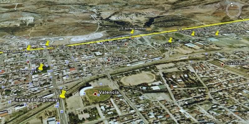
No matter which way you come into Tecate, the U.S. border access road is on the east side of town off the free Mexicali highway.. well signed:
===========================================
Coming north from Ensenada or Hwy. 2-D central Tecate exit... Fork to right, on blvd. along train tracks... big McDonalds is across the blvd. ahead if
you went straight.
If you miss this turn, continue ahead to the town plaza/ park and turn right at the far corner (free Mexicali highway)!
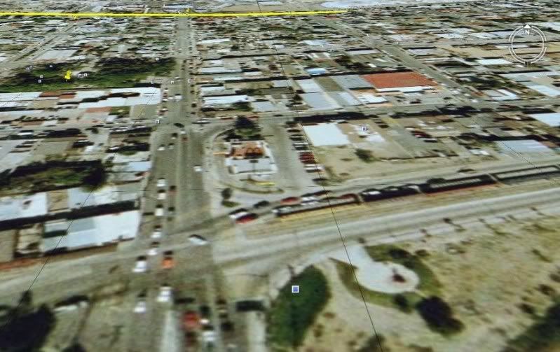
Fork left here, driving away from the train tracks (San Diego & Arizona Eastern Railroad, originally):
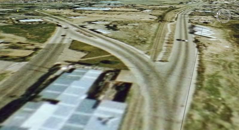
"Trafic Circle" with trees and stop signs (be sure to make a full stop, police may be watching). Go to right, east from circle:
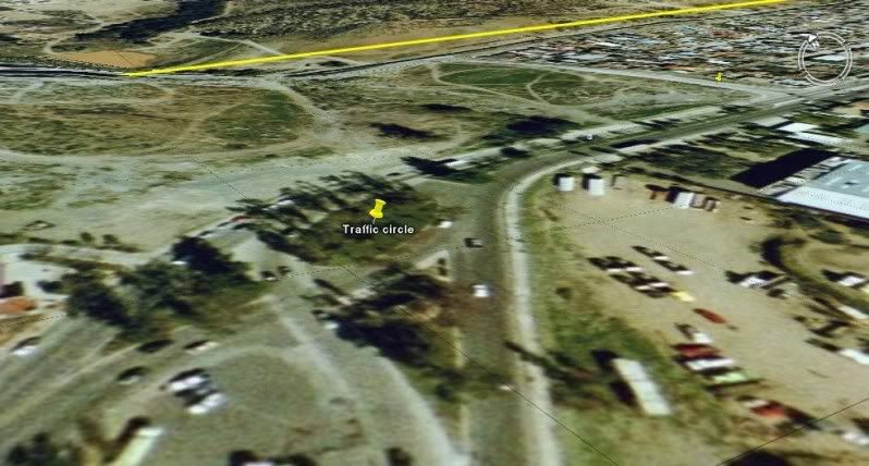
Turn left a short distance east of traffic circle for U.S. Border:
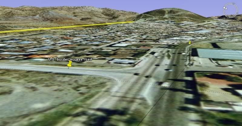
A look west along the border:
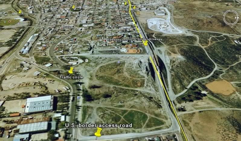
Remember, Tecate border is not open 24 hours! 5am to 11 pm, last I recall.
|
|
|
David K
Honored Nomad
        
Posts: 65086
Registered: 8-30-2002
Location: San Diego County
Member Is Offline
Mood: Have Baja Fever
|
|
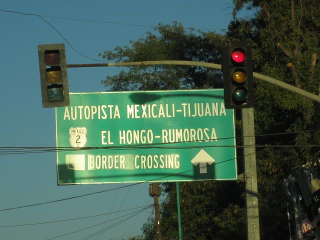
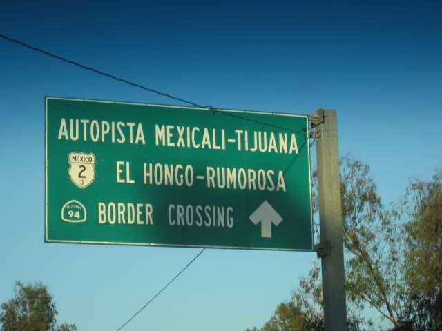
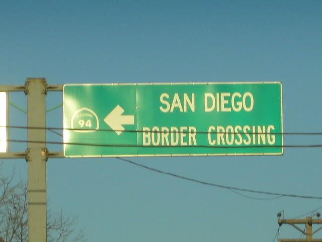
Here are some of the signs as you drive through Tecate showing you the way to the U.S. border:
|
|
|
absinvestor
Senior Nomad
  
Posts: 725
Registered: 11-28-2009
Member Is Offline
|
|
Thanks David. I appreciate the info and attachments. Ron
|
|
|
toneart
Ultra Nomad
    
Posts: 4901
Registered: 7-23-2006
Member Is Offline
Mood: Skeptical
|
|
DavidK,
Your maps are detailed, but I find them confusing, and I know the route well. Here is what bothers me, and also, my suggested correction:
In the first map photo, at the first yellow pin, turn right. You can clearly see the big stadium (marked "Valencia" on your map) on your right,
at the rounded corner. (McDonalds is across the intersection.)That is the road on which the railroad tracks parallel. You are rounding he corner with
the stadium on your right.
After that, follow the clear signage, as you show. Continue past the treed traffic circle and look for the sign to turn left...and then you turn left
again where it dead ends, onto the border road with the solid yellow line at the top of the map.
What was confusing for me is that the solid yellow line you show only runs at the top of the maps.That is the straight road that heads west to the
U.S. border. I think it would be helpful if you showed the yellow line all along the route.
You are always helpful and it is not my purpose to criticize. I only want to make it easier. What do you think?
For those who first crossed the border at Tecate, going south into Mexico, it is a lot simpler. You go through the border check area and continue
straight to the plaza. Turn left and go to the corner of the plaza and turn right. You are now on the road that leads up to the highway.
It would seem logical to retrace that route to the border going north...Wrong! You have to turn at the stadium, according to the map,
and go east for several blocks...then left, then left again and then head west (the opposite direction).
Tony
|
|
|
David K
Honored Nomad
        
Posts: 65086
Registered: 8-30-2002
Location: San Diego County
Member Is Offline
Mood: Have Baja Fever
|
|
Hi Tony, YES you are exactly correct! Thank you for adding the info. The yellow line is not mine, but Google Earth's line to show the U.S. border (not
the road).
Every turn from either Ensenada, Tijuana or Mexicali to the U.S. border entrance is signed...
I welcome any improved maps to show the route, as well as clarifications like what Tony has added!
|
|
|
absinvestor
Senior Nomad
  
Posts: 725
Registered: 11-28-2009
Member Is Offline
|
|
To both Tony and David- Thanks a million. These will make it easy for my friend to get to the border. To Tony: your directions on going south are
perfect. On our last trip South I parked on the US side and walked to Hwy 3 just to be sure of the route and was amazed at how easy it was. On the
other hand, on our return I found the route North to be a little confusing. Thanks again. Ron
|
|
|
absinvestor
Senior Nomad
  
Posts: 725
Registered: 11-28-2009
Member Is Offline
|
|
I forgot to mention that on my last trip North what confused me was the sign that David shows saying San Diego-Border Crossing. When I go to San Diego
I go thru Tijuana and when I saw the sign I thought that they were taking me back West to Tijuana. Now that I see the sign on paper I see it clearly
says California 94. Thanks again- Ron
|
|
|
David K
Honored Nomad
        
Posts: 65086
Registered: 8-30-2002
Location: San Diego County
Member Is Offline
Mood: Have Baja Fever
|
|
Yah, its like what else is in the U.S. but San Diego if you read that sign for what it says!
U.S.A. or as Mexico calls it: EE.UU. would be more accurate on the sign! They go use 'GARITA' a lot (for border crossing).
[Edited on 2-5-2011 by David K]
|
|
|
bajalou
Ultra Nomad
    
Posts: 4459
Registered: 3-11-2004
Location: South of the broder
Member Is Offline
|
|
This is only for me - applies to no one else.
I find it difficult to orient myself if N is not up - top of the map.
And the angle views distort things for me also. I can get a lot out of a map if it is straight down and North at top of the map.
The angle views from all sides are great for looking at a feature on the map, but not for navigation.
Keep up the good work on mapping.
No Bad Days
\"Never argue with an idiot. People watching may not be able to tell the difference\"
\"The trouble with doing nothing is - how do I know when I\'m done?\"
Nomad Baja Interactive map
And in the San Felipe area - check out Valle Chico area |
|
|
David K
Honored Nomad
        
Posts: 65086
Registered: 8-30-2002
Location: San Diego County
Member Is Offline
Mood: Have Baja Fever
|
|
Yes, I am the same way Lou...
However, a lot would rather see the view as it looks from their car, driving... so, that is the direction of view (the small compass in the top right
on Google Earth shows you which way is north).
I can do a series with north at top, if anyone would like to see it that way!
|
|
|
bajalou
Ultra Nomad
    
Posts: 4459
Registered: 3-11-2004
Location: South of the broder
Member Is Offline
|
|
Maybe one shot, flat N up of the entire area?
No Bad Days
\"Never argue with an idiot. People watching may not be able to tell the difference\"
\"The trouble with doing nothing is - how do I know when I\'m done?\"
Nomad Baja Interactive map
And in the San Felipe area - check out Valle Chico area |
|
|
David K
Honored Nomad
        
Posts: 65086
Registered: 8-30-2002
Location: San Diego County
Member Is Offline
Mood: Have Baja Fever
|
|
| Quote: | Originally posted by bajalou
Maybe one shot, flat N up of the entire area? |
Other than being 'flat'...
that's how I started showing them, above... or do you mean something different than this one?:

[Edited on 2-5-2011 by David K]
|
|
|
David K
Honored Nomad
        
Posts: 65086
Registered: 8-30-2002
Location: San Diego County
Member Is Offline
Mood: Have Baja Fever
|
|
I will add a flat (straight overhead) one... but to fill it all in, it may be a bit high? I will do it next time I log onto Google Earth...
|
|
|
David K
Honored Nomad
        
Posts: 65086
Registered: 8-30-2002
Location: San Diego County
Member Is Offline
Mood: Have Baja Fever
|
|
Here it is... above Tecate, north at top

|
|
|
bajalou
Ultra Nomad
    
Posts: 4459
Registered: 3-11-2004
Location: South of the broder
Member Is Offline
|
|
Good work David.
No Bad Days
\"Never argue with an idiot. People watching may not be able to tell the difference\"
\"The trouble with doing nothing is - how do I know when I\'m done?\"
Nomad Baja Interactive map
And in the San Felipe area - check out Valle Chico area |
|
|
absinvestor
Senior Nomad
  
Posts: 725
Registered: 11-28-2009
Member Is Offline
|
|
Just wanted to thank David K and Toneart again. I crossed at Tecate on October 10th. Great directions. I crossed around noon and there were only three
cars ahead of me!! (Less than a 5 minute wait.) 32' motorhome with tow car easily made the entrance at the border exit. The directions worked
perfectly!! Ron
|
|
|
David K
Honored Nomad
        
Posts: 65086
Registered: 8-30-2002
Location: San Diego County
Member Is Offline
Mood: Have Baja Fever
|
|
| Quote: | Originally posted by absinvestor
Just wanted to thank David K and Toneart again. I crossed at Tecate on October 10th. Great directions. I crossed around noon and there were only three
cars ahead of me!! (Less than a 5 minute wait.) 32' motorhome with tow car easily made the entrance at the border exit. The directions worked
perfectly!! Ron |
Wonderful! 
|
|
|
bajaboolie
Nomad
 
Posts: 277
Registered: 9-24-2007
Location: Aptos, CA/Mulege
Member Is Offline
|
|
With all the fabulous maps, (thanks David K!) I would like to add some peace of mind. We drove through to the Tecate border on Saturday for the first
time at David K's suggestion a couple of weeks ago. If you've ever gone through Tijuana, you will find this completely refreshing. Yes, the road
signs are clear, but more important to me was that if you happened to miss one, it is very easy (not confusing or stressful) to turn around and pick
right back up (unlike Tijuana). We had one car in front of us at the border.
Thanks again, David K. We'll never go north through Tijuana again. 
Bajaboolie
|
|
|
David K
Honored Nomad
        
Posts: 65086
Registered: 8-30-2002
Location: San Diego County
Member Is Offline
Mood: Have Baja Fever
|
|
| Quote: | Originally posted by bajaboolie
With all the fabulous maps, (thanks David K!) I would like to add some peace of mind. We drove through to the Tecate border on Saturday for the first
time at David K's suggestion a couple of weeks ago. If you've ever gone through Tijuana, you will find this completely refreshing. Yes, the road
signs are clear, but more important to me was that if you happened to miss one, it is very easy (not confusing or stressful) to turn around and pick
right back up (unlike Tijuana). We had one car in front of us at the border.
Thanks again, David K. We'll never go north through Tijuana again. 
|
You are very welcome!!   
|
|
|

