| Pages:
1
2 |
David K
Honored Nomad

Posts: 64568
Registered: 8-30-2002
Location: San Diego County
Member Is Offline
Mood: Have Baja Fever
|
|
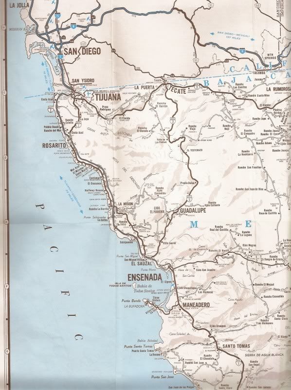
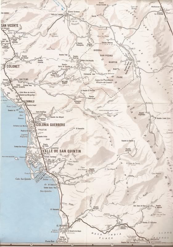
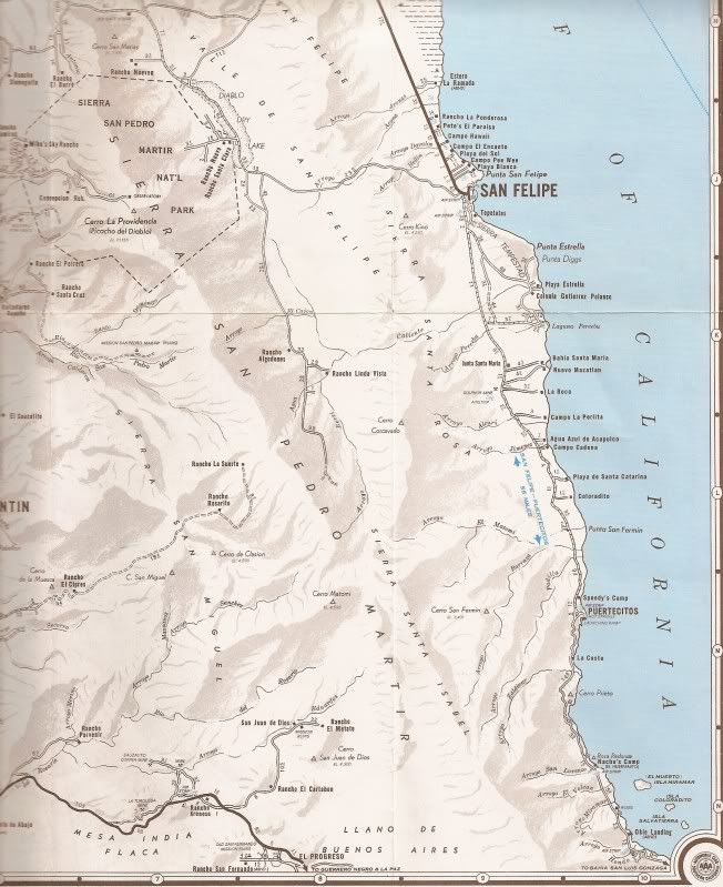
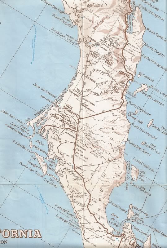
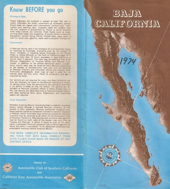
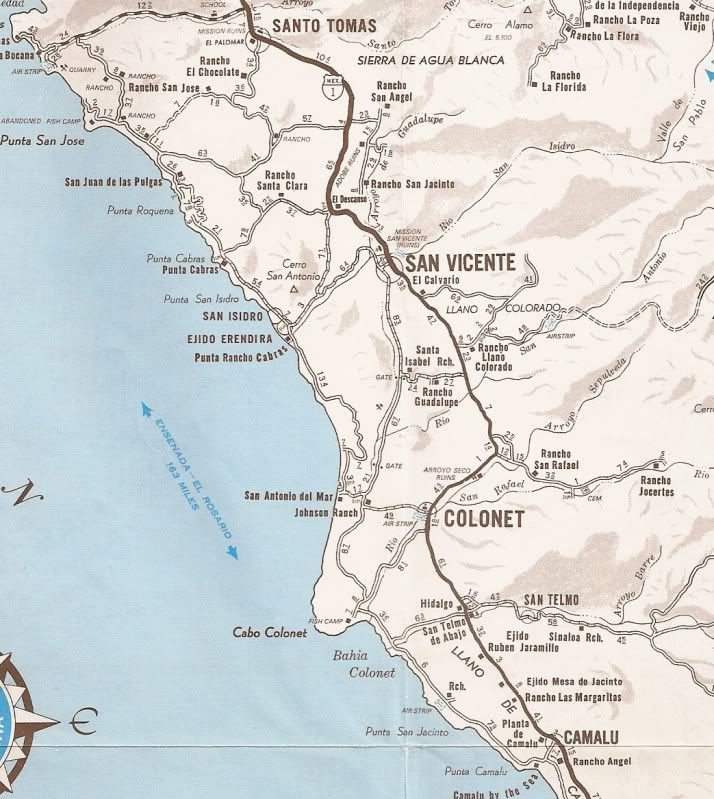
1974 Baja Map from Auto Club (from Barry A)
In the early 1970's the Auto Club of Southern California produced a vary detailed map of northern Baja... and the remainder of Baja was on the other
side... which was the same style map as their 1960's Baja map, but the fishing and hunting notes were removed. In 1975, they totally remade the map
with Baja split into north and south halves that they continued to use up to the last version (2007).
However, they reduced the scale and details found on their early 70's map.
My only copy is badly marked and ripped... and when Barry A told me he had a good copy he would send me, I was thrilled to say the least!
So, here is that April, 1974 edition of the Baja map... the first one with the completed Baja highway on it, as well!
If anyone would like a close up zoom of any of these maps, just let me know which one of the 10, and what area of the map. The only part of Baja I
didn't get scanned was the far east corner along the border (Algodones/ San Luis R.C.). Let me know if you want to see that.
Again a BIG NOMAD thank you to Barry A!!!
The Northern detail map... two scans west then east, with three cross sections north to south:
[Edited on 2-18-2011 by David K]
|
|
|
David K
Honored Nomad
Posts: 64568
Registered: 8-30-2002
Location: San Diego County
Member Is Offline
Mood: Have Baja Fever
|
|
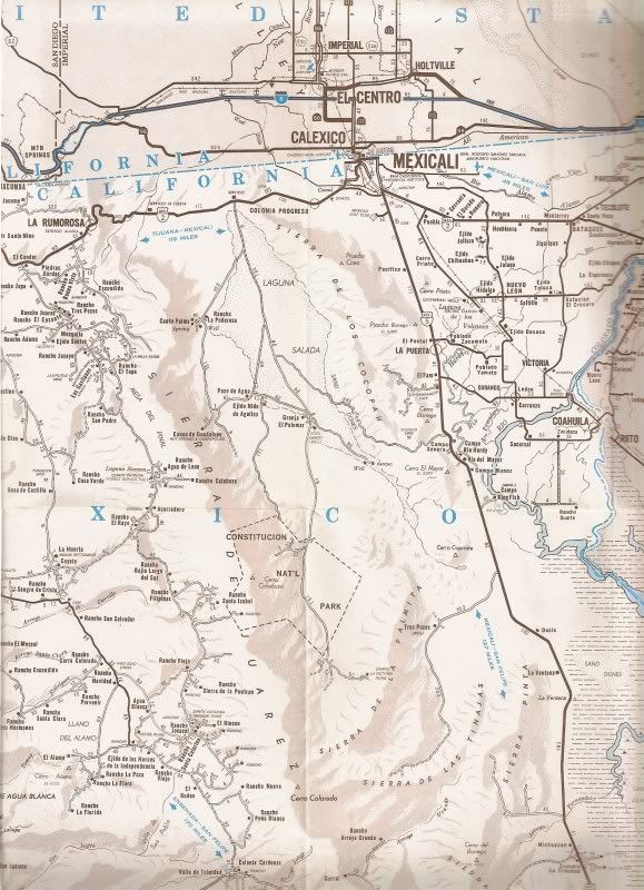
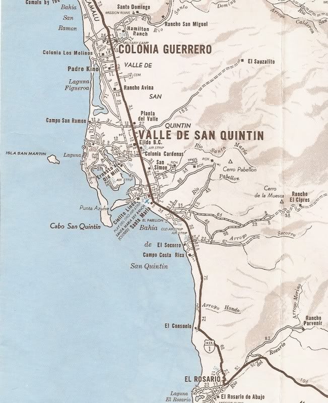
The other side of the map for the rest of Baja:
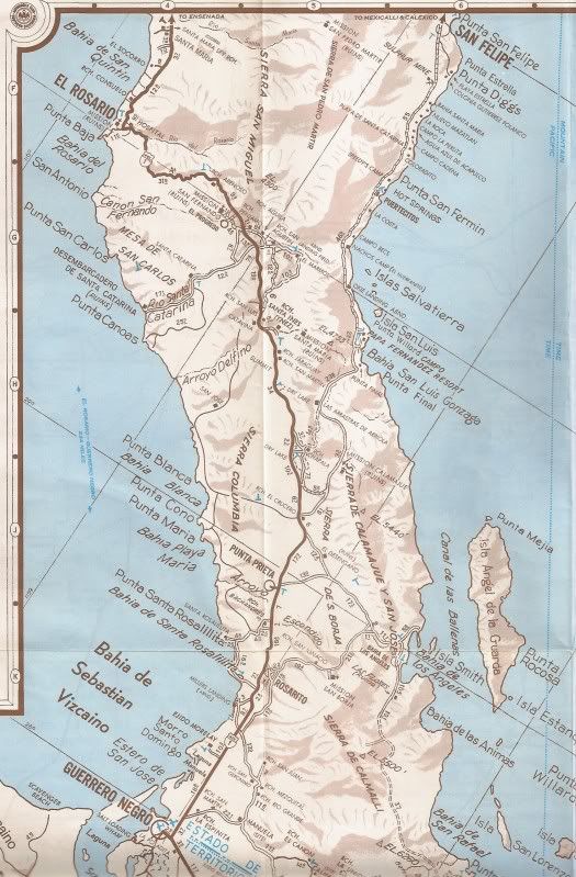
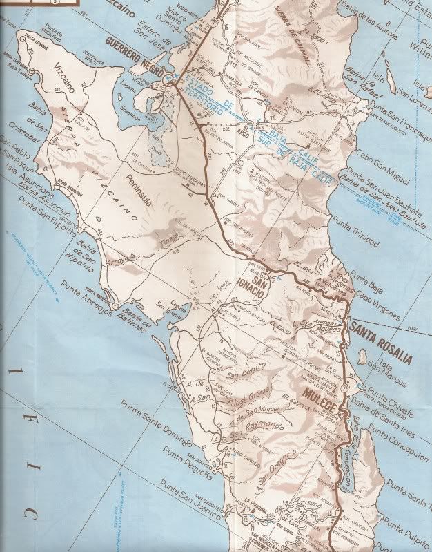
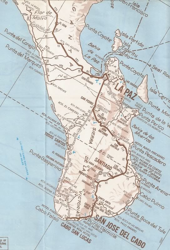
These almost 37 year old maps are a look back in time, and posted here for educational purposes.
|
|
|
KurtG
Super Nomad
Posts: 1202
Registered: 1-27-2004
Location: California Central Coast
Member Is Offline
Mood: Press On Regardless!!
|
|
That is the map that guided me on my first motorcycle ride to Baja in October 1974. Had a 73 Honda 750 which I rode to La Paz and then to Cabo San
Lucas. I spent a week in Mulege and have never stopped returning there. I don't have as many round trips as Pompano but probably around 100 over
those 37 years. I have recently finished putting together a 1981 CB750 which I am soon going to ride to Mulege just for pure nostalgia purposes.
|
|
|
captkw
Ultra Nomad
Posts: 3850
Registered: 10-19-2010
Location: el charro b.c.s.
Member Is Offline
Mood: new dog/missing the old 1
|
|
oops!! I think I just did a blank post,,(I can hear my ex,laughing) I hvae that same map up in ca. at my northern home..is the front dark brown ??
|
|
|
Barry A.
Select Nomad
Posts: 10007
Registered: 11-30-2003
Location: Redding, Northern CA
Member Is Offline
Mood: optimistic
|
|
| Quote: | Originally posted by captkw
oops!! I think I just did a blank post,,(I can hear my ex,laughing) I hvae that same map up in ca. at my northern home..is the front dark brown ??
|
Yes, the cover is brown and blue.
DK I am really impressed with your scanning of that map-------it came out great. Glad I was able to help.
Barry
|
|
|
David K
Honored Nomad
Posts: 64568
Registered: 8-30-2002
Location: San Diego County
Member Is Offline
Mood: Have Baja Fever
|
|
| Quote: | Originally posted by Barry A.
| Quote: | Originally posted by captkw
oops!! I think I just did a blank post,,(I can hear my ex,laughing) I hvae that same map up in ca. at my northern home..is the front dark brown ??
|
Yes, the cover is brown and blue.
DK I am really impressed with your scanning of that map-------it came out great. Glad I was able to help.
Barry |
Thank you Barry... because of your sharing, the entire world wide web can enjoy this map!
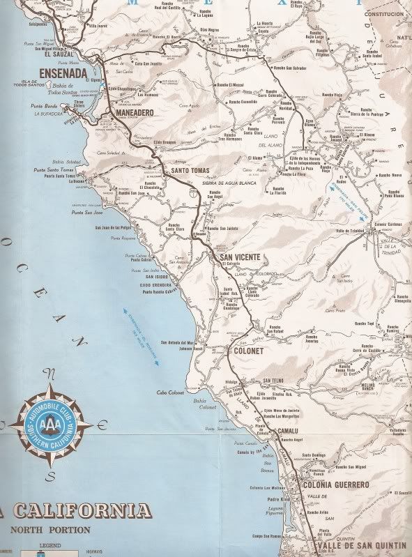
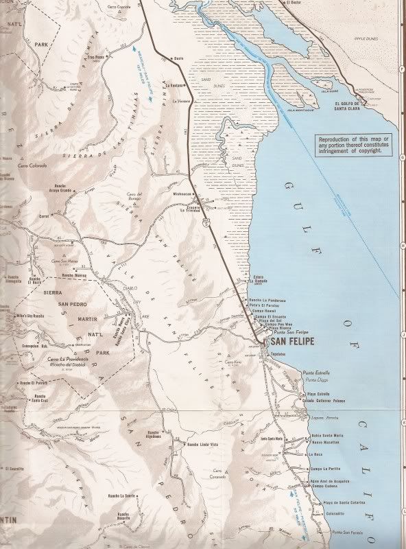
I have a couple of close-up requests... I am going to do them now (Ensenada area and San Felipe area)... Stand by Nomads! 
|
|
|
David K
Honored Nomad
Posts: 64568
Registered: 8-30-2002
Location: San Diego County
Member Is Offline
Mood: Have Baja Fever
|
|
| Quote: | Originally posted by Barry A.
| Quote: | Originally posted by captkw
oops!! I think I just did a blank post,,(I can hear my ex,laughing) I hvae that same map up in ca. at my northern home..is the front dark brown ??
|
Yes, the cover is brown and blue.
DK I am really impressed with your scanning of that map-------it came out great. Glad I was able to help.
Barry |
|
|
|
David K
Honored Nomad
Posts: 64568
Registered: 8-30-2002
Location: San Diego County
Member Is Offline
Mood: Have Baja Fever
|
|
Close Ups...
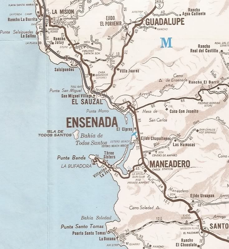
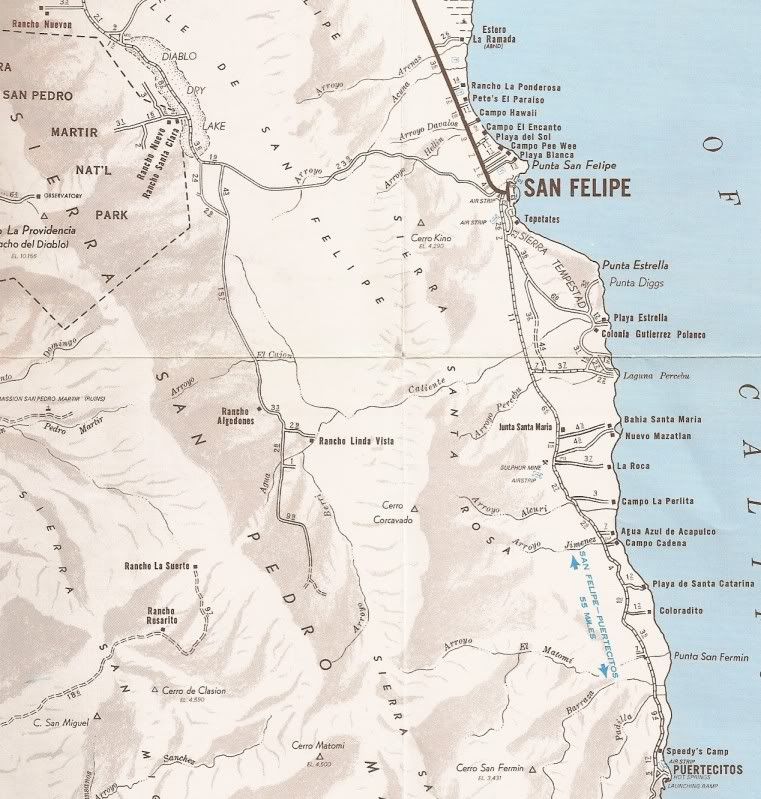
If you have a request... or even closer zoom than above, just ask!
|
|
|
David K
Honored Nomad
Posts: 64568
Registered: 8-30-2002
Location: San Diego County
Member Is Offline
Mood: Have Baja Fever
|
|
No map is without errors, rather intentional or not...
The national park in the Sierra Juarez (around Laguna Hanson) is mis-located out in the desert. La Roca didn't have its own seperat road from the
sulfur mine, it branched off the Nuevo Mazatlan road. Nuevo Mazatlan is shown too close to Bahia Santa Maria... it is really about halfway to La Roca
from BSM. Just a couple I remembered from back in the day...
|
|
|
captkw
Ultra Nomad
Posts: 3850
Registered: 10-19-2010
Location: el charro b.c.s.
Member Is Offline
Mood: new dog/missing the old 1
|
|
yep,, that's the same map that I have,,,,cool
|
|
|
David K
Honored Nomad
Posts: 64568
Registered: 8-30-2002
Location: San Diego County
Member Is Offline
Mood: Have Baja Fever
|
|
Remember, I honor all requests for close ups from any map I have...
|
|
|
Bob H
Elite Nomad
Posts: 5867
Registered: 8-19-2003
Location: San Diego
Member Is Offline
|
|
Fantastic posting David. Just fantastic.
THANK YOU!
You need to have your own TV show, like a Huel Howser type of show, called Baja's Gold!
[Edited on 3-4-2011 by Bob H]
The SAME boiling water that softens the potato hardens the egg. It's about what you are made of NOT the circumstance.
|
|
|
ncampion
Super Nomad
Posts: 1238
Registered: 4-15-2006
Location: Loreto
Member Is Offline
Mood: Retired and Loving it
|
|
Great job. My first trip all the way down was 1979 and I think that was the map that I used. Good old AAA. Can't beat them.
|
|
|
Barry A.
Select Nomad
Posts: 10007
Registered: 11-30-2003
Location: Redding, Northern CA
Member Is Offline
Mood: optimistic
|
|
AAA maps---------were the gold standard for years.
Not so much anymore. They have removed countless "roads" from their maps lately (what's with that??), and I don't believe they can be counted on
anymore, and are not near the quality maps they used to be. I believe that they contract out their map making now, and have disbanded their own "map
staff", from what I understand.
(Sigh-----)
Barry
|
|
|
David K
Honored Nomad
Posts: 64568
Registered: 8-30-2002
Location: San Diego County
Member Is Offline
Mood: Have Baja Fever
|
|
| Quote: | Originally posted by Barry A.
AAA maps---------were the gold standard for years.
Not so much anymore. They have removed countless "roads" from their maps lately (what's with that??), and I don't believe they can be counted on
anymore, and are not near the quality maps they used to be. I believe that they contract out their map making now, and have disbanded their own "map
staff", from what I understand.
(Sigh-----) when I was helping them update their map
Barry |
The removing of dirt roads from the map or classification of graded roads as 'unimproved' or 'poor' roads on the last couple of ACSC (Auto Club of
Southern Calif.) Baja maps had to do with complaints received by members who had a tough time or thought the road shown as graded should have been
good enough for their Honda Civic, etc. and they got there to find a washout or something... Sad that people have become so weak or complaint
oriented!
Oh, I was told this by one of the Auto Club Baja team members when I was sharing some road conditions with them...
I think the 2007 edition was the final one... although I sure hope not!
[Edited on 3-4-2011 by David K]
|
|
|
racheldarlin
Junior Nomad
Posts: 69
Registered: 9-30-2010
Member Is Offline
|
|
Great job with the scanning David.
Barry, Thanks and what I want to know is how you kept a '74 map in such great condition? My first AAA was a '98 and in a couple of year ago it looked
like mice had tried to make a nest. Finally got tired of wasting a roll of tape on it every year and tossed it. (Also I went to the Almanac)
I talked to my local AAA guy and he said GPS and Google had pretty much made it not worth producing paper maps any more.
|
|
|
Barry A.
Select Nomad
Posts: 10007
Registered: 11-30-2003
Location: Redding, Northern CA
Member Is Offline
Mood: optimistic
|
|
Rachael Darling------------I have always been a map-fanatic, picking up 2 of every map---one for filing, and one for actually using. But in this case
I inherited that pristine Map from my deceased Aunt who was a Baja fanatic and map-nut, like me, and who taught me to always buy 2 of all maps for the
reason stated above.
I love my paper maps, tho the ON-line maps are really neat. I don't have a lap-top, so when on the road I want my paper maps, which I often laminate
with plastic so they won't "fall apart".
It saddens me that paper-maps are fast becoming a thing of the past-----I have spent countless hours studying my "paper maps" over the many
years----------I have hundreds of them in my file cabinets.
I supervised the BLM mapping of the southern CA desert (San Diego, Imperial, and Riverside Counties) in the mid-70's, the result being the present day
Recreation Guide Maps that BLM publishes--------excellent maps with infinite detail, and I believe the best available today. (I am proud of that
effort, obviously) 
So there you have more info than you ever wanted to learn. 
Thanks for asking.
Barry
|
|
|
David K
Honored Nomad
Posts: 64568
Registered: 8-30-2002
Location: San Diego County
Member Is Offline
Mood: Have Baja Fever
|
|
Wonderful Barry!
Any viewers who love old maps... be sure and look down this forum (Baja Historic Interests and Literature) as I have posted many, many maps dating
back to 1701... and if you have a map that you don't see... please share it... email me for details on how.
|
|
|
David K
Honored Nomad
Posts: 64568
Registered: 8-30-2002
Location: San Diego County
Member Is Offline
Mood: Have Baja Fever
|
|
San Pedro Martir Mountain Ranches

An interesting look at the mountain area.
While this was a 1974 map, some of the mapping information must of come from around 1969, as the road north from Mike's Sky Rancho (built around 1970)
to San Matias/ Valle de Trinidad is not included.
The observatory road built also about 1968-1970 is not shown, but a road up from Concepcion ranch is... not sure if it ever was possible to get
through that way... past Corral de Sam ?
Also, there never was an automobile road to Mision San Pedro Martir as shown... A difficult foot trail up the side of the mountain has always been the
only way from Santa Cruz.
|
|
|
Mexitron
Ultra Nomad
Posts: 3397
Registered: 9-21-2003
Location: Fort Worth, Texas
Member Is Offline
Mood: Happy!
|
|
yes, the old road built for logging got you up at least to the high meadows of the SPM...don't know about a road going up to the observatory area
though.
What's the road heading south of R. Santa Cruz and appearing to come tantalizingly close to the Mission?
Has anyone taken the road from the current observatory road to R. Santa Cruz in recent years? I was on it in 1990-ish and it looked like it could
wash out easily. The road west of Santa Cruz at that time was overgrown and in not too good a shape with many locked gates to get through to end up
in the San Telmo Valley area.
|
|
|
| Pages:
1
2 |


