| Pages:
1
2
3
4
5
6
..
23 |
elbeau
Nomad

Posts: 256
Registered: 3-2-2011
Location: Austin, TX
Member Is Offline
|
|
If I'm right about the Dam & Reservoir, then it's pretty likely that a lot of the other disturbances in the river bed could also be other dams
& reservoirs. There are a few others I think I've nailed down, but they involved even more guesswork than the one I'm showing. One of the others
would be near the base of the path going up the hill that has arches. Since that is one of the most accessible places at the site it's worth looking
around that river bed below the arches, even if I can't be as definitive with the particulars that I think I see there.
|
|
|
elbeau
Nomad
Posts: 256
Registered: 3-2-2011
Location: Austin, TX
Member Is Offline
|
|
Here's a higher-level shot with some broader features noted:

|
|
|
elbeau
Nomad
Posts: 256
Registered: 3-2-2011
Location: Austin, TX
Member Is Offline
|
|
That X-Shaped feature is the crossroads of two very well used trails as far as I can tell. One direction leads directly to my so-called "mission
site". Another direction follows a trail through some mountains and valleys then gets lost in the desert. If you were to continue the direction of
the trail after it gets lost in the desert you would find that it is aimed to go around the only mountain between this site and the Santa Maria
mission. That could mean that the Jesuits made the trail, but it's certainly not built in their traditional style. I think it's more likely that
it's an older trail leading to the oasis that Santa Maria was later built upon.
|
|
|
mcfez
Elite Nomad
Posts: 8678
Registered: 12-2-2009
Location: aka BN yankeeirishman
Member Is Offline
|
|
If you read my original post you would know that I tried to contact 9 professors at 4 major universities.
You did. Sorry.
I still say something aint right...the way you presented all of this, 9 professors at 4 major universities not getting involved,
and the fact that the area seems to be well covered by previous folks.. We had too many sand dollar stories here.
Like I said....I will remain quiet on this unless spoken too.
Old people are like the old cars, made of some tough stuff. May show a little rust, but good as gold on the inside.
|
|
|
elbeau
Nomad
Posts: 256
Registered: 3-2-2011
Location: Austin, TX
Member Is Offline
|
|
Fair enough
|
|
|
mcfez
Elite Nomad
Posts: 8678
Registered: 12-2-2009
Location: aka BN yankeeirishman
Member Is Offline
|
|
| Quote: | Originally posted by elbeau
Fair enough |
I do as said before...hope I am wrong. Good luck with this hunt.
Old people are like the old cars, made of some tough stuff. May show a little rust, but good as gold on the inside.
|
|
|
Barbareno
Nomad
Posts: 410
Registered: 11-4-2007
Location: Vernon BC
Member Is Offline
|
|
| Quote: | Originally posted by gon2srf
Best thread in a while. Looking forward to seeing pictures of the site. Ruins or not, it's a great read. |
It sure is.
|
|
|
Brian L
Nomad
Posts: 250
Registered: 6-21-2010
Location: Alpine, CA
Member Is Offline
Mood: No Bad Days
|
|
Who are you?
After going to the app website, I'm still not sure who you are. Below is the info from your about us page, very elusive, and no mention of people's
names (who are "we""?
About Us
Elbeaus.com is committed to bringing you the geology of our world using the best of today's technology.
Utilizing today's smart phone technology and geo positioning systems, we create applications that open the earth and help you make geologic
discoveries.
In cooperation with Nevada Mineral & Book Company, we have been creating geology applications since 2000. As technology has adapted, so have we,
and now we can present Terraphone, the world's first application to merge geologic and paleontologic occurrence data with the enabling power of the
iPhone.
...Sure, there are many applications to help you "re-find" geographical places and man-made things... But only Terraphone provides you with the best
tools for making new geological discoveries.
Terraphone's strength is not in helping you find things that other people have already found. Terraphone provides you with detailed information about
the occurrences of rocks, minerals, fossils, gemstones, and other geologic information. By tying this information to the real-time data and
positioning systems available in today's smart phones, such as the iPhone, YOU now have the power to make YOUR OWN DISCOVERIES!
So fire up Terraphone! ...and start exploring your earth toda
Brian
|
|
|
Brian L
Nomad
Posts: 250
Registered: 6-21-2010
Location: Alpine, CA
Member Is Offline
Mood: No Bad Days
|
|
Also, thanks for the Google links. I have a decent res monitor, and am admittedly not a geologist or archaeologist, but I think you are stretching
things a LOT!
I'd like to hear more on how you make the stretch (your words) from seeing something in a satellite image to an archaeological find...
You truly could be on to something here. Or you may have thought Tuesday was April 1st not March 1st.
Brian
|
|
|
David K
Honored Nomad
Posts: 64478
Registered: 8-30-2002
Location: San Diego County
Member Is Offline
Mood: Have Baja Fever
|
|
Good Morning... Well, I did try to downplay the original post by elbeau so his 'secret' would be protected a bit longer. In any case, he has produced
his close ups for you all to see and ponder... Great, Baja is about history, adventure and exploration. I did send the GPS to three other Nomads for
their help in trying to see if there is something man-made there.
The arroyo is EL VOLCAN, but the Mexican topo and Baja Almanac has mis-named it Zamora. The site is only 3 miles 'downstream' from where the El
Marmol-La Olvidada mine road crosses Arroyo el Volcan... which is just 1/2 mile from the El Volcan Geyser (onyx dome)... http://vivabaja.com/marmol
The arroyo is dry except for the springs at El Volcan which are very mineralaized (creating onyx) and nothing edible can grow in that water.
Motorcycle riders have traveled down Arroyo el Volcan (Zamora) from the El Marmol road seeking a short cut to the gulf (near El Huerfanito)... A dry
waterfall dropoff has prevented the use of this arroyo.
Mexican prospectors have digs all over the area. The site (if it was a mission ruin) would have been seen by either prospectors, ranchers or off
roaders.
However, Baja is a land of adventure... I would be happy to go back to El Volcan and go down the arroyo to the site to take photos of what these rock
piles really look like. Who knows... maybe elbeau has indeed found something... and if not, it is still a great adventure to dream about or do!
[Edited on 3-3-2011 by David K]
|
|
|
Jack Swords
Super Nomad
Posts: 1094
Registered: 8-30-2002
Location: Nipomo, CA/La Paz, BCS
Member Is Offline
|
|
Conjecture can go on and on. There is only one definitive solution and that is on the ground. It doesn't appear to be a difficult trip, several
folks have indicated a willingness to drive/hike in. Until that happens nothing can be conclusive.
Having spent mucho time following rumored leads all over the backcountry of Baja, even a nonproductive adventure is just that, an adventure. However,
at times one can be rewarded with success, but usually that just creates more questions. So, in the end, it's Baja, full of the unknown and
unexpected. Nothing wrong with that.
|
|
|
elbeau
Nomad
Posts: 256
Registered: 3-2-2011
Location: Austin, TX
Member Is Offline
|
|
| Quote: | Originally posted by Jack Swords
Conjecture can go on and on. There is only one definitive solution and that is on the ground. It doesn't appear to be a difficult trip, several
folks have indicated a willingness to drive/hike in. Until that happens nothing can be conclusive.
Having spent mucho time following rumored leads all over the backcountry of Baja, even a nonproductive adventure is just that, an adventure. However,
at times one can be rewarded with success, but usually that just creates more questions. So, in the end, it's Baja, full of the unknown and
unexpected. Nothing wrong with that. |
Well said. I'm not trying to create an endless debate here. All I want is some on-the-ground confirmation or a picture of the 95-foot shrub that is
making me see things wrong 
|
|
|
mtgoat666
Select Nomad
Posts: 17289
Registered: 9-16-2006
Location: San Diego
Member Is Offline
Mood: Hot n spicy
|
|
get some better photos, they are out there and free on web
Don't waste your time with Google sat photos. the google earth photos are very limited.
you arm chair explorers should download the Landsat 7 SID raster images, and view with a free viewer like Lizardtech.
good luck chasing shadows!
|
|
|
David K
Honored Nomad
Posts: 64478
Registered: 8-30-2002
Location: San Diego County
Member Is Offline
Mood: Have Baja Fever
|
|
How about showing them here goat...? It would be real refreshing to have a possitive contribution from you instead of the typical criticism... Can you
do this? Thank you.
|
|
|
TMW
Select Nomad
Posts: 10659
Registered: 9-1-2003
Location: Bakersfield, CA
Member Is Offline
|
|
Corky ll and I rode MCs down the wash and then hiked another mile or so a few years ago, maybe 5 or 6. Corky spent more time looking over the
landscape than I as he felt there may be an overland route to the Sea of Cortez. I walked to the horse shoe bend past the first group of caves and
stairs etc. WE did not see anything unusual. We were looking for a way to ride a MC up the side of the hill and not for historial stuff. The wash
itself gets pretty bad with boulders etc.
|
|
|
TMW
Select Nomad
Posts: 10659
Registered: 9-1-2003
Location: Bakersfield, CA
Member Is Offline
|
|
I'm going down to the SF250 race next week leaving on Thursday from here. Since I was going to check out the Turquesa mine wash hill I think I'll stop
by this site first and see what it shows. If anyone else is going at that time let me know.
|
|
|
David K
Honored Nomad
Posts: 64478
Registered: 8-30-2002
Location: San Diego County
Member Is Offline
Mood: Have Baja Fever
|
|
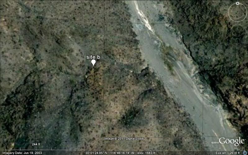
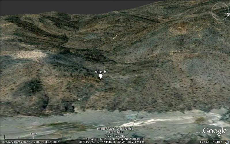
That would be great TW... take as many photos of the site and include a look from the arroyoup to it and from it down to the arroyo. This should clear
up a lot.
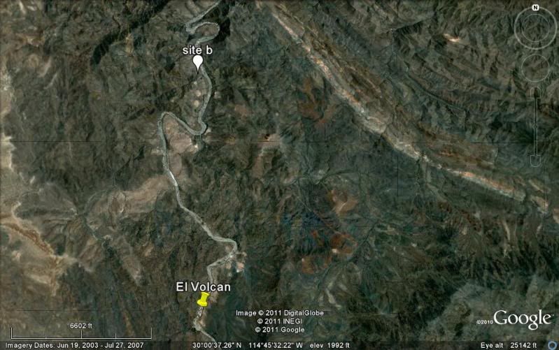
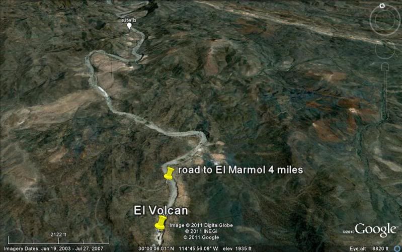
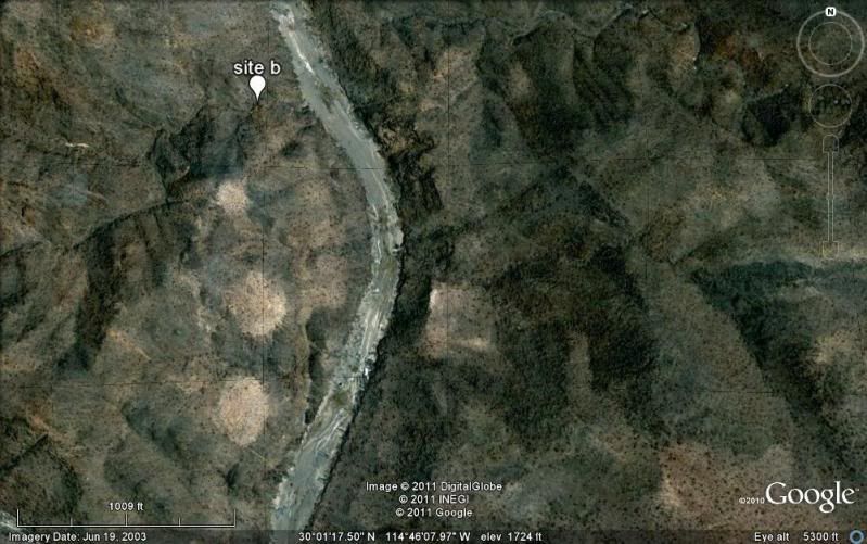
Here are my Google Earth images of the site (marked with white balloon 'site b') from high to close with north at top, and sideways (west) from the
arroyo.
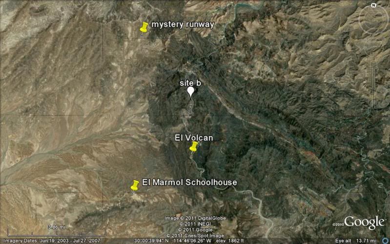
The 'mystery runway' is at the end of a road that branches left, 2.0 miles from El Marmol off the El Volcan road. It is a ditched drug runner
airstrip. There are others in this part of Baja!
|
|
|
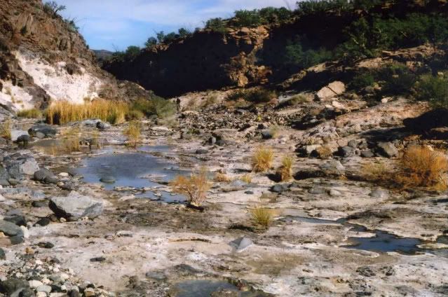
wilderone
Ultra Nomad
Posts: 3778
Registered: 2-9-2004
Member Is Offline
|
|
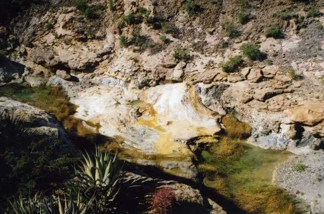
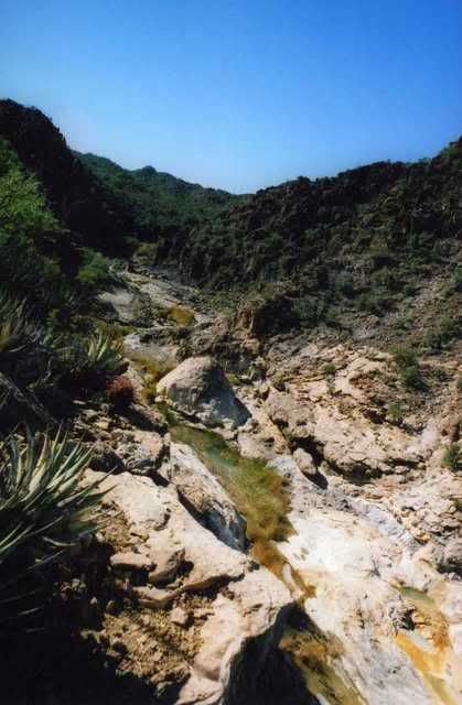
Ive been down this arroyo at least 3 miles. About ½ mi. from the arroyo junction (where if you crossed it would continue to the mine), to the
right, there are some pools, some new onyx domes, streams, where Im sure following a big rain, an area could fill to resemble a lake. Further down
the arroyo we saw lots of borrego prints, lots of tamarask, but we didnt venture on either side of the arroyo up any cliffs or side canyons, etc.
Its really great country for a hike. Some views of an area where pools accumulate and new onyx is being created.
|
|
|
elbeau
Nomad
Posts: 256
Registered: 3-2-2011
Location: Austin, TX
Member Is Offline
|
|
| Quote: | Originally posted by TW
I'm going down to the SF250 race next week leaving on Thursday from here. Since I was going to check out the Turquesa mine wash hill I think I'll stop
by this site first and see what it shows. If anyone else is going at that time let me know. |
YAY! I can survive two more weeks...I guess
Can't wait to see what you do or don't find.
|
|
|
David K
Honored Nomad
Posts: 64478
Registered: 8-30-2002
Location: San Diego County
Member Is Offline
Mood: Have Baja Fever
|
|
Thanks Wilderone for sharing some of your beautiful El Volcan photos!
|
|
|
| Pages:
1
2
3
4
5
6
..
23 |


