MaxStar
Junior Nomad

Posts: 30
Registered: 2-22-2011
Location: Oakland, CA
Member Is Offline
|
|
Santa Rosalillita to Catavina
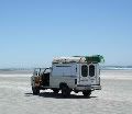
Hey guys I'll be driving from La Paz to San Diego next month. I'd like to drive out to Santa Rosalillita, up the coast and back in to Catavina. Has
anyone done this recently? How are the roads?Is it difficult to navigate? Any recomondations for beach camping this stretch? Is it safe?
Thanks for the input!
-Max
|
|
|
David K
Honored Nomad
Posts: 65563
Registered: 8-30-2002
Location: San Diego County
Member Is Offline
Mood: Have Baja Fever
|
|
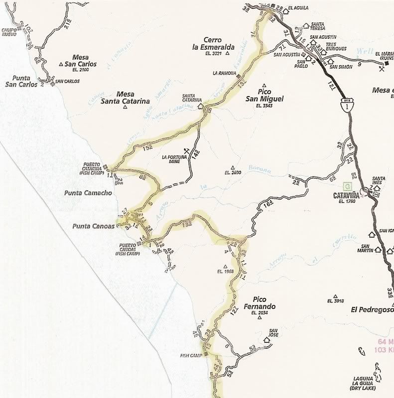
I have a road log from north to south... but we went to first to Santa Catarina Landing, from near Guayaquil/ San Agustin... 22 miles north of the
Faro San Jose road, on Hwy. 1 (the road closer to Cataviña)... This trip was made in July, 2007 in a 4WD Tacoma and Land Rover LR3. The trip was
reported here on Nomad and in a web page http://vivabaja.com/707 with photos:
I will edit out the last section south of Santa Rosalillita to Hwy. 1 past Punta Rosarito.
ROAD LOG: THE DISTANT PACIFIC
Road Log 194.7 miles from Hwy. 1 to Hwy.1
The route along the Pacific is a way one can experience a little of what it was like to drive the length of Baja before Highway 1 was constructed
between 1967 and 1974 (Dec. '73).
The route shown on the map is almost 200 miles and there are no services or fuel until Santa Rosalillita or beyond at Villa Jesus Maria.
Total (and partial) mileage shown from my Tacoma odometer. AAA map mileages for the same section of road were the same or very close to mine.
0.0 (0.0) Take the signed right turnoff to 'Santa Catarina (32 km)' 46.9 miles from El Rosario's Pemex. The road is between Km. 132 and 133. Just
ahead (on Hwy. 1) is the road left to Guayaquil.
This is a good, fast graded road for the first 30 or so miles and it is fun to drive through beautiful cactus gardens.
7.2 (7.2) Road in from left to San Agustin along the old route from El Marmol... where onyx blocks were trucked to the Pacific at Santa Catarina
Landing to be shipped north.
19.2 (12.0) pass through tree shaded Rancho Santa Catarina.
21.1 (1.9) Fork, left to Punta Canoas and right for Santa Catarina Landing... we go right. The road climbs to the the top of a ridge and then drops
down to the coastal plain. The original road used to haul onyx over can be seen to the north.
36.3 (15.2) Fork, we first take right fork and it goes 3.4 miles to fish camp 'Punta Blu'... dead end, so back to this fork and take left branch.
37.3 (1.0) Road left is the route south... ahead goes 1.0 mile to Santa
Catarina fish camp, on the beach.
38.1 (0.8) Turn left and head away from coast.
47.3 (9.2) Come to the Punta Canoas road which forked at Mile 21.1 above. Turn right.
51.3 (4.0) Road to left... we continued straight.
52.3 (1.0) Road to left... we continued straight.
55.2 (2.9) Junction... Ahead goes 1.1 miles to high, look out/ view point, above Punta Canoas... To continue south, turn left.
58.5 (3.3) Join with road heading south (probably coming from the roads that turned left at Mile 51.3 and 52.3).
62.0 (3.5) Puerto Canoas Fish Camp.
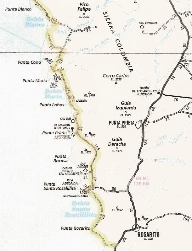
Reset odometer to 0.0 for the next section of the road log.
========================================
0.0 (0.0) Puerto Canoas Fish Camp.
We first travel across the arroyo valley to investigate a modern, large home/ building near the beach... then head east.
1.8 (1.8) Big house facing beach on south side of arroyo. Head east, as no road is seen going south, close to the beach.
The auto club map shows the road we are on and we make camp at Mile 8.0 at the base of a pointy hill... about where the mileage '13.9' is shown on the
AAA map.
The Baja Almanac only shows this road as a trail. Our first night camp is to the east of the word 'Mujeres' (an arroyo) on Almanac Map 17.
17.4 (15.6) Pass a pair of graves and come to a cross road at an abandoned ranch. This should be the road from Hwy. 1 near Cataviña going to Faro San
Jose. We turn right.
19.6 (2.2) Cross road, fenced entrance. Continue ahead.
21.5 (1.9) Join newer, graded road... continue ahead.
22.6 (1.1) Green school(?), fork to right.
33.1 (10.5) Road in from right, continue ahead.
35.5 (2.4) Fork, go right.
37.4 (1.9) Road to El Mirador to right, continue ahead.
39.6 (2.2) Arroyo San Jose fish camp.
We want to stay near to the coast, and find a poor 'Jeep' road that does just that. After 6 slow miles we near Bahia Corbin and drive out onto the
point on the north side of the bay for a lunch break. Finally, a beautiful looking beach... but a fish camp is there, too.
46.0 (6.4) Bahia Corbin, north end camping area on side road, just off coastal road.
Reset trip odometer to 0.0.
========================================
0.0 (0.0) Bahia Corbin. Return short distance to coastal road by fish camp and continue south.
8.8 (8.8) Arroyo La Pintada valley and road to east (to Laguna Chapala?).
10.4 (1.6) A second road going east which I am pretty sure is the unmapped road to Laguna Chapala on Hwy. 1.
16.0 (5.6) Road to coast at Bahia Blanco. We continue south.
The main road swings inland along Arroyo El Sauz, but we see a lesser dirt road cutting across the marsh (was dry) area staying nearer the coast and
take it. This is not shown on the AAA map or Almanac.
21.7 (5.7) Meet newly graded roadbed on south side of Arroyo El Sauz. This soon follows the 'poor' road location shown on the Almanac and AAA map.
29.3 (7.6) After lots of silt on the graded roadbed we come to the north-south (now graded) road between Cordonices and Punta Maria. We turn right on
the fast road, or better called 'dirt highway'.
34.5 (5.2) Road to right goes to Punta Cono. We continue south.
42.2 (7.7) Bahia Maria beach, near Punta el Diablo
43.0 (0.8) El Cardon ranch.
46.1 (3.1) Road to beach 0.4 mi., just south of Punta Lobos.
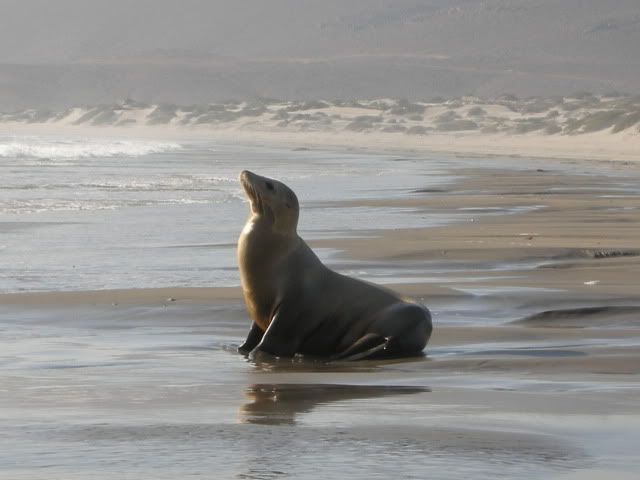
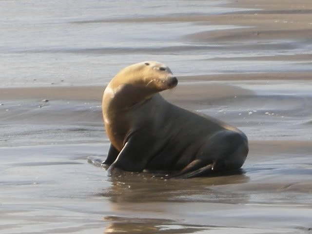
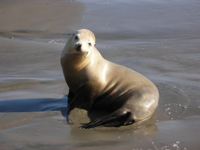
We are pooped from so much hard driving and want to make camp, so we go to the beach for a look.
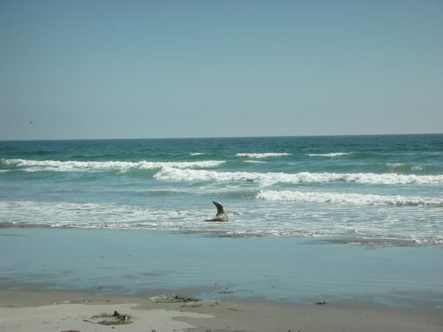
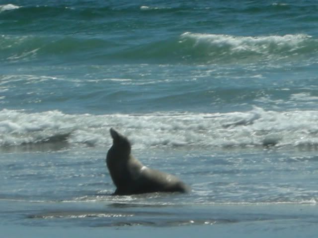
We drive down the beach to find a camp site in the Valle los Ojitos dunes. A sea lion (lobo) is on the shore... photos.
========================================
0.0 (0.0) Beach road (Punta Lobos/ Valle los Ojitos)
6.8 (6.8) Road west to El Marron fish camp (near Punta Prieta/ Punta Negra). Road (or dirt highway here) heads away from the coast around the Sierra
San Andres.
17.0 (10.2) Cross Arroyo San Andres
17.2 (0.2) Road west signed to '3 Alejandras' (Puerto San Andres).
21.1 (3.9) Come to PAVED Santa Rosalillita highway, turn right for the coast. (Hwy. 1 is about 8 miles to the left)
22.1 (1.0) FORK, Escalera Nautica Harbor is 1.2 miles to right. Straight ahead goes to:
22.5 (0.4) Santa Rosalillita village on the beach. Gas and supplies available.

|
|
|
TMW
Select Nomad
Posts: 10659
Registered: 9-1-2003
Location: Bakersfield, CA
Member Is Offline
|
|
I Suggest you take a copy of DKs road log and map to help find the right turns toward Catavina as you get close to the end.
Also be aware of silt beds north of Punta Negra to south of Bahia Blanco area. I understand large trucks hauling rocks are the cause. If necessary get
out and check it out before driving thru it.
There are many great beaches along the way for camping. One of my favorites is Bahia Blanco. Great fishing early morning and evening before dark.
I did a trip report back in 2009 and camped at Bahia Blanco. http://forums.bajanomad.com/viewthread.php?tid=39975&pag...
|
|
|
David K
Honored Nomad
Posts: 65563
Registered: 8-30-2002
Location: San Diego County
Member Is Offline
Mood: Have Baja Fever
|
|
I can email you a higher resolution of the map unless you have the AAA map, then you can tell what roads I was on.
|
|
|
Bob H
Elite Nomad
Posts: 5867
Registered: 8-19-2003
Location: San Diego
Member Is Offline
|
|
This is GREAT stuff!
The SAME boiling water that softens the potato hardens the egg. It's about what you are made of NOT the circumstance.
|
|
|
rob
Senior Nomad
Posts: 509
Registered: 10-19-2004
Location: Pacific Coast, BCS
Member Is Offline
|
|
As TW reminded me, there was a spot south of Bahia Blanca where we hit the worst silt beds I have ever driven in (on the Baja Almanac map, it was just
to the south of T-junction marked with a graveyard (?) and named "Codornices".
The fine silt ran down the windshield like heavy rain - I tried to remember when I last cleaned the air filter . . . the engine exhaust brake
butterfly valve had jammed shut and the exhaust temp readings were off the scale, but couldn't stop.
Dog day afternoon.
|
|
|
MaxStar
Junior Nomad
Posts: 30
Registered: 2-22-2011
Location: Oakland, CA
Member Is Offline
|
|
Awesome guys, thanks! Yeah I've got both the AAA map and the Almanac. How's the camping on the beach? Can you see people camping from the road? Is
this a safe stretch? Thanks again!
|
|
|
David K
Honored Nomad
Posts: 65563
Registered: 8-30-2002
Location: San Diego County
Member Is Offline
Mood: Have Baja Fever
|
|
| Quote: | Originally posted by MaxStar
Awesome guys, thanks! Yeah I've got both the AAA map and the Almanac. How's the camping on the beach? Can you see people camping from the road? Is
this a safe stretch? Thanks again! |
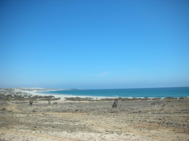
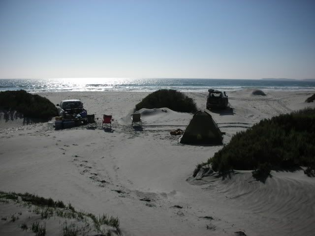
We camped in the dunes next to the beach just south of Punta Lobos. This is where I took the sea lion up close photo.
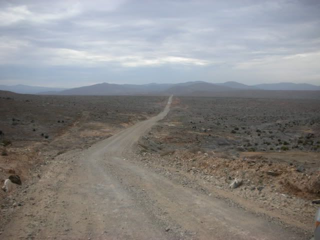
Okay, here are the photos I took near Punta Lobos:
There is an access road onto the beach where the dirt highway is closest to the ocean, just south of Punta Lobos.
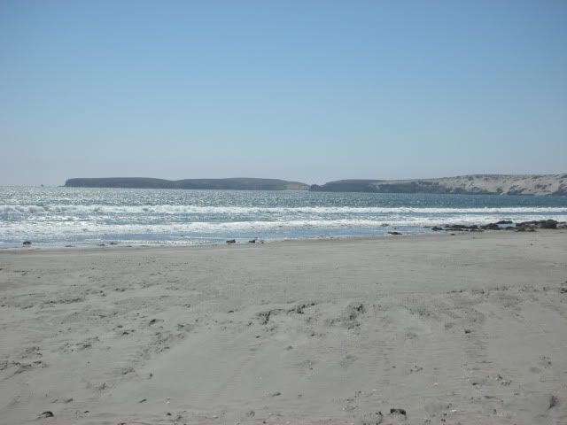
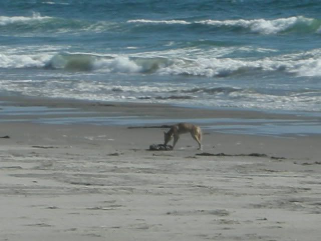
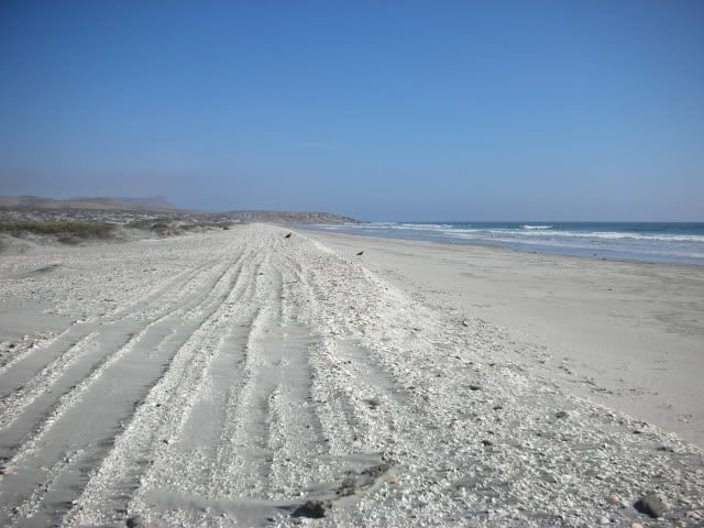
The next day, here is the road heading south from Punta Lobos:
In 2007, this good dirt highway/ graded road (with kilometer posts) extended almost to Bahia Blanca... we took the coastal route across Arroyo El Sauz
(not shown on maps) and not inland via Cordonices. There was thick silt (Baja dust) just north of Punta Cono.
|
|
|
TMW
Select Nomad
Posts: 10659
Registered: 9-1-2003
Location: Bakersfield, CA
Member Is Offline
|
|
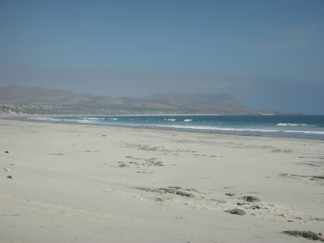
In many cases yes you can see the road from the beach area and in others the beach drops out of site. At Bahia Blanco on the north end is a fish camp
one of the men came down to talk to us last Nov. Friendly, no problem, he spoke very little english. The fish camp is just above where it says Bahia
Blanco in the almanac, black dot. I prefer to camp closer to the second red dot to the SE of there. There is a road leading to a rock formation in the
middle of the beach area. I camped there and I could see a couple of trucks go by on the main road. You would have to check it out.
Just a note of advice. The fishermen I have encountered have always been friendly. I often sometimes traded beer for fish. Becareful when giving them
beer as one can lead to another and to another. Give them one beer each if you want then move on. If they drink too much things can get out of hand.
It's not like you are family or friends but a stranger. That was advice Coco gave me several years ago.
|
|
|
David K
Honored Nomad
Posts: 65563
Registered: 8-30-2002
Location: San Diego County
Member Is Offline
Mood: Have Baja Fever
|
|
Here's a better look at our 2007 route for those who don't have a AAA map handy:
[Edited on 4-20-2011 by David K]
|
|
|
MaxStar
Junior Nomad
Posts: 30
Registered: 2-22-2011
Location: Oakland, CA
Member Is Offline
|
|
Awesome, guys. Thanks again. Will let you know how goes!
|
|
|
David K
Honored Nomad
Posts: 65563
Registered: 8-30-2002
Location: San Diego County
Member Is Offline
Mood: Have Baja Fever
|
|
Great and welcome to Baja Nomad!
|
|
|