| Pages:
1
2
3
4 |
Neal Johns
Super Nomad

Posts: 1687
Registered: 10-31-2002
Location: Lytle Creek, CA
Member Is Offline
Mood: In love!
|
|
The Pole Line Road did not go up/down summit, it went up/down Canyon Jamau. "In a few miles we passed the bottom of the "precipitous" Canyon Jamau and
as last we were on the Pole Line Road"
Coming down out of Canyon Jaquegel, it followed the present race course road, either to Hwy. 5 or Hwy. 3.
The washout southeast mentioned toward San Felipe has been bypassed a few hundred yards downstream (by Ken?) and is passable now. A friend and I
touched it up a couple of years ago.
I don't know why it did not go through Valle de Trinidad (Hwy. 3 route from the west coast), maybe no road across the peninsula then?
My motto:
Never let a Dragon pass by without pulling its tail!
|
|
|
David K
Honored Nomad
Posts: 64479
Registered: 8-30-2002
Location: San Diego County
Member Is Offline
Mood: Have Baja Fever
|
|
From Gene Kira's MexFish.com
MILK RUN (LITERALLY)
The first trip I made to San Felipe in Mexico was to deliver dairy products to the Army radar station in the spring of 1942.
Sometime, in about April I think, my dad pulled me out of the second grade, and we got into a 1938 Dodge truck and headed for San Felipe.
The truck was filled with milk, butter, eggs, cheese and ice cream and we were headed for the army base at San Felipe.
Because of the war, there was a 35 m.p.h. speed limit, and we spent the night at Calexico, at the Anza Hotel, I think.
We got up early the next morning. I don't remember having to stop going in either direction at the border. We crossed at Calexico and it was marked
as the border, but I don't think there was any official border activity.
We were not far out of town, across the border, when we were stopped at the first of maybe four check points before we reached San Felipe. These
stops were manned by American soldiers, not Mexicans.
My dad explained that we were going to a military installation in San Felipe that had just been built, and what it did was listen for airplanes using
something called radar. In the last six months, the Army had built a paved road to San Felipe called the radar road which made the drive south a
lot easier than it had been, unlike the month-long ordeal of mud and flood up until 1942.
What we drive on today is the radar road, although it has been paved a couple of times since then.
I may be the only person to remember driving on that stretch of road during World War II who is still alive today. I can remember, the water was
right up to the road's edge in places, and my dad said that if it were not for the road, we'd have to wait for the tides to change and for the mud to
dry out.
The base was near where the old icehouse was until recently, and we were stopped from driving into the main area. About 20 young soldiers came out
to the barbed-wire fence and had the truck unloaded in a very short time, and we turned right around and headed home.
|
|
|
David K
Honored Nomad
Posts: 64479
Registered: 8-30-2002
Location: San Diego County
Member Is Offline
Mood: Have Baja Fever
|
|
http://www.northamericanforts.com/Latin/mexico.html#radar
American WWII Air Defense Radar Stations
(1942 - 1943), State of Baja California (Norte)
During the early years of WWII the U.S. Army built and manned at least three SCR-270 early warning anti-aircraft radar stations along the coast of
Baja California Norte, operated by the 654th AWS Company, to protect the southern approaches to San Diego, California. Known sites include Station
B-92 at Punta Salispuedes, located 22 miles northwest of Ensenada (later moved to Alasitos, 36 miles south of Tijuana); Station B-94 at Punta San
Jacinto, 60 miles south of Ensenada; and Station B-97 at Punta Estrella (Diggs), south of San Felipe on the Gulf of California (aka Sea of Cortez).
==============================================
(DK personal note):
When I was younger, I also had heard that the radar station was out at Punta Estrella/ Punta Diggs. The MexFish post says it was near the ice house in
San Felipe...?
[Edited on 8-4-2011 by David K]
The type of radar installed in Baja... an SCR-268:

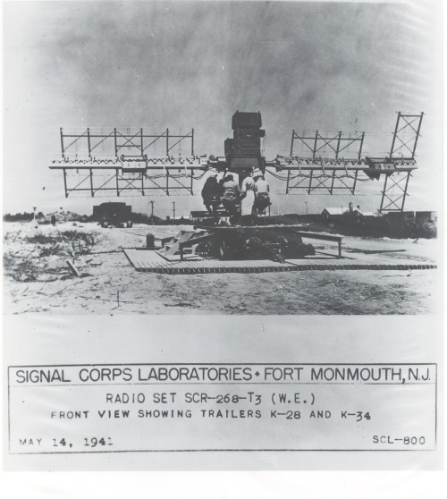
SCR-270:
http://en.wikipedia.org/wiki/SCR-270_radar#/media/File:SCR-2...
Edit... the 270 vs the 268 radar:
http://en.wikipedia.org/wiki/SCR-270_radar
http://en.wikipedia.org/wiki/SCR-268_radar
[Edited on 4-3-2015 by David K]
|
|
|
David K
Honored Nomad
Posts: 64479
Registered: 8-30-2002
Location: San Diego County
Member Is Offline
Mood: Have Baja Fever
|
|
Arrangements were made between the U.S. Government and the Government of Mexico to allow joint teams of U.S. Army officers and Mexicans Army officers
and soldiers to patrol the Mexican peninsula of Baja California. The teams were platoon-size units and patrolled all the way to the southern tip of
the peninsula. There were persistent rumors early in the war that the Japanese might have secret air bases in Baja California, but no evidence of this
was ever found. The American officers were required to wear civilian clothing and all U.S. markings had to be removed from U.S. Army vehicles and
other equipment to accommodate Mexico's neutrality laws.
|
|
|
Ken Cooke
Elite Nomad
Posts: 8921
Registered: 2-9-2004
Location: Riverside, CA
Member Is Offline
Mood: Black Trans Lives Matter
|
|
@David K
Exactly where did you locate all of this great information? 
|
|
|
David K
Honored Nomad
Posts: 64479
Registered: 8-30-2002
Location: San Diego County
Member Is Offline
Mood: Have Baja Fever
|
|
| Quote: | Originally posted by Ken Cooke
Exactly where did you locate all of this great information?
|
The INTERNET (it's on computers now)! 
(seriously, at the bottom of Nomad pages is the Google Search... that is where... then I went through many pages using various search words)
|
|
|
David K
Honored Nomad
Posts: 64479
Registered: 8-30-2002
Location: San Diego County
Member Is Offline
Mood: Have Baja Fever
|
|
More...
MEXICO 197
AWS Detachment 1 B-92 654th SAW Company
Signal Aircraft Warning (US) Punta Salispuedes, 22 miles northwest of Ensenada (moved to Alasitos, 36 miles south of Tijuana) Mexico
AWS Detachment 2 B-94 654th SAW Company
Punta San Jacinto, 60 miles South of Ensenada
AWS Detachment 3 B-97 654th SAW Company
Punta Estrella, near San Felipe on the Gulf
(Also called Punta Diggs198 199 )
|
|
|
Neal Johns
Super Nomad
Posts: 1687
Registered: 10-31-2002
Location: Lytle Creek, CA
Member Is Offline
Mood: In love!
|
|
Great work, DK. I had tried to Google for Pole Line info a few years ago and failed.
You now have a new title: GoogleMeister? GooglerDoodler? Let the name contest begin! :-) :-) :-)
By the way, two of my friends from work and I found the Pole Line Road in the late 1970's by noticing the road/valley going south from Guadalupe Hot
Springs and wondering where it went. Due to breakdowns/running out of gas/poor maps (only an WWII Aeronautical map)/no knowledge of race routes and
our hilarious attempts at dead reckoning navigation, it took five trips! Books and good maps came later and I sucked them up.
Ah, to be young and innocent again. :-) :-) :-)
Thanks for starting this post, Ken
My motto:
Never let a Dragon pass by without pulling its tail!
|
|
|
TMW
Select Nomad
Posts: 10659
Registered: 9-1-2003
Location: Bakersfield, CA
Member Is Offline
|
|
Neal back then did you go both ways? I mean up the mtn toward Ensenada as well as to the east. If so what was the road like then, better, worse or
about the same depending on the rains etc.
|
|
|
Skipjack Joe
Elite Nomad
Posts: 8084
Registered: 7-12-2004
Location: Bahia Asuncion
Member Is Offline
|
|
| Quote: | Originally posted by Neal Johns
You now have a new title: GoogleMeister? GooglerDoodler? Let the name contest begin! :-) :-) :-)
|
Yankee Google?
<groan>
|
|
|
BajaGringo
Ultra Nomad
Posts: 3882
Registered: 8-24-2006
Location: La Chorera
Member Is Offline
Mood: Let's have a BBQ!
|
|
An old guy I met in Vicente Guerrero a few years back who told me he remembered a U.S. military base of some kind at Punta Jacinto when he was a kid.
I listened and just rolled my eyes, sure at the time the old guy was in the early stages of dementia.
Turns out he knew what he was talking about...
|
|
|
Skipjack Joe
Elite Nomad
Posts: 8084
Registered: 7-12-2004
Location: Bahia Asuncion
Member Is Offline
|
|
"When I was a boy of fourteen, my father was so ignorant I could hardly stand to have the old man around. But, when I got to be twenty-one, I was
astonished at how much he had learned in seven years."

|
|
|
Neal Johns
Super Nomad
Posts: 1687
Registered: 10-31-2002
Location: Lytle Creek, CA
Member Is Offline
Mood: In love!
|
|
TW,
I have only gone south, ever.
The main changes are due to weather, of course, and are usually:
1. The last hill down leaving the Canyon Jaquegel area (camper pic in an above DK post - Marian driving).
2. The long uphill, left side downslope, a mile or so before 1. gets narrower every year.
3. The arroyo crossing after passing the road up Canyon Jamau - unless it is before.
4. The hill I named Basketball Hill because it was full of basketball sized boulders the first time (which we moved). No locker in my FJ-40, so it was
full bore all the way. A little rain and they fall back into the arroyo/road.
My motto:
Never let a Dragon pass by without pulling its tail!
|
|
|
TMW
Select Nomad
Posts: 10659
Registered: 9-1-2003
Location: Bakersfield, CA
Member Is Offline
|
|
The last time I was on the PLR (Dec, 07) a huge rock rolled into the Rd path just after the turn from the wash to go up basketball hill. I'd have to
look to see if I have a picture but Ken had his jeep's winch tied to it and was trying to push it. It was funny as the rock was pulling Ken to it. We
finally went up and around it.
|
|
|
BAJACAT
Ultra Nomad
Posts: 2902
Registered: 11-21-2005
Location: NATIONAL CITY, CA
Member Is Offline
|
|
can you see the PLR on google earth..? can find it..
BAJA IS WHAT YOU WANTED TO BE, FUN,DANGEROUS,INCREDIBLE, REMOTE, EXOTIC..JUST GO AND HAVE FUN.....
|
|
|
wessongroup
Platinum Nomad
Posts: 21152
Registered: 8-9-2009
Location: Mission Viejo
Member Is Offline
Mood: Suicide Hot line ... please hold
|
|
| Quote: | Originally posted by Skipjack Joe
"When I was a boy of fourteen, my father was so ignorant I could hardly stand to have the old man around. But, when I got to be twenty-one, I was
astonished at how much he had learned in seven years." |
A classic... 
|
|
|
Ken Cooke
Elite Nomad
Posts: 8921
Registered: 2-9-2004
Location: Riverside, CA
Member Is Offline
Mood: Black Trans Lives Matter
|
|
TW on the Pole Line Road
| Quote: | Originally posted by TW
The last time I was on the PLR (Dec, 07) a huge rock rolled into the Rd path just after the turn from the wash to go up basketball hill. I'd have to
look to see if I have a picture but Ken had his jeep's winch tied to it and was trying to push it. It was funny as the rock was pulling Ken to it. We
finally went up and around it. |


|
|
|
David K
Honored Nomad
Posts: 64479
Registered: 8-30-2002
Location: San Diego County
Member Is Offline
Mood: Have Baja Fever
|
|
| Quote: | Originally posted by BAJACAT
can you see the PLR on google earth..? can find it.. |
Yes!
Shall I show it here?
Here is the 2009 post with all of Neal Johns' waypoints: http://forums.bajanomad.com/viewthread.php?tid=37224
[Edited on 8-5-2011 by David K]
|
|
|
BAJACAT
Ultra Nomad
Posts: 2902
Registered: 11-21-2005
Location: NATIONAL CITY, CA
Member Is Offline
|
|
Thanks DK..if this trip happens, I will consider, riding with somebody..I will help with expences.Ken says it's not a good Idea to take my Big RAM, on
this trip..
BAJA IS WHAT YOU WANTED TO BE, FUN,DANGEROUS,INCREDIBLE, REMOTE, EXOTIC..JUST GO AND HAVE FUN.....
|
|
|
TMW
Select Nomad
Posts: 10659
Registered: 9-1-2003
Location: Bakersfield, CA
Member Is Offline
|
|
There are places where a long wheel base could be a problem. When the weather gets cool Ken should do another PLR run and Jose I would be happy to
have you ride in the luxury of a Toyota Tacoma. Mind you I don't crawl over big boulders like Ken and his Jeep friends, I either crash thru them or go
around.
|
|
|
| Pages:
1
2
3
4 |


