| Pages:
1
2 |
David K
Honored Nomad

Posts: 64478
Registered: 8-30-2002
Location: San Diego County
Member Is Offline
Mood: Have Baja Fever
|
|
The First Road Built in Baja: EL CAMINO REAL
I wrote this for my web site (VivaBaja.com) back in 2003... Here it is with some changes. The place names in CAPS can be found in the Baja California
Almanac (which does show much of the mission trail)...
"El Camino Real" means The Royal Road or as Harry Crosby calls it "The King's Highway". There actually are many Camino Reals in the New World, built
after the Spanish conquered most of the Western Hemisphere.
The purpose was to connect important points and population centers in the new territories. Gold and other treasures, including tax revenues, were
transported back to the king, in part on the various "Royal Roads".
In California, we are most familiar with El Camino Real as the route Franciscan padre Junipero Serra traveled when he established a chain of missions
here, beginning in 1769. Today, four-lane paved expressways bear the name El Camino Real wherever the new street was built on or near the old trail.
Junipero Serra and the El Camino Real both began not in San Diego, but 700 miles further south, in LORETO.
In fact, long before Serra and his Franciscan brothers came to Baja California, the chain of missions and the connecting Camino Real were well
established by the Jesuit Order (Society of Jesus) of the Catholic Church, starting in 1697!
After the end of the mission period in Baja, much of the Camino Real continued to be the main route of transportation until the automobile arrived on
the scene.
Highway 1, from El Rosario north to Tijuana is built on or very near the original trail with only a couple of exceptions.
Three modern travel writers have documented the El Camino Real to help us find the old trail as it winds through Baja. Unlike Alta California, almost
no signs or paved roads show the route in Baja from Loreto to El Rosario.
The first modern travel account was written by Arthur North, published in 1910, named Camp and Camino in Lower California . North is considered to be
the first "tourist" to travel the length of Baja for adventure and research.
The next detailed account is an unpublished report (with maps) by Howard Gulick in 1955. Gulick was researching Baja for his future Lower California
Guidebook . He noted the location of older trails he saw crossing the newer auto dirt roads both from the ground and from aerial photos he was
privileged to take. Gulick and co-author Peter Gerhard rode mules on sections of El Camino Real, as well.
The unpublished report and personal conversations with Gulick was of great assistance to the third author, Harry Crosby in his research for The King's
Highway in Baja California , published in 1974. Crosby traveled the entire route of the old trail by mule with local guides. His book contains many
photos and maps of the entire Camino Real.
================================================
Finding El Camino Real in Baja California, Loreto to El Rosario:
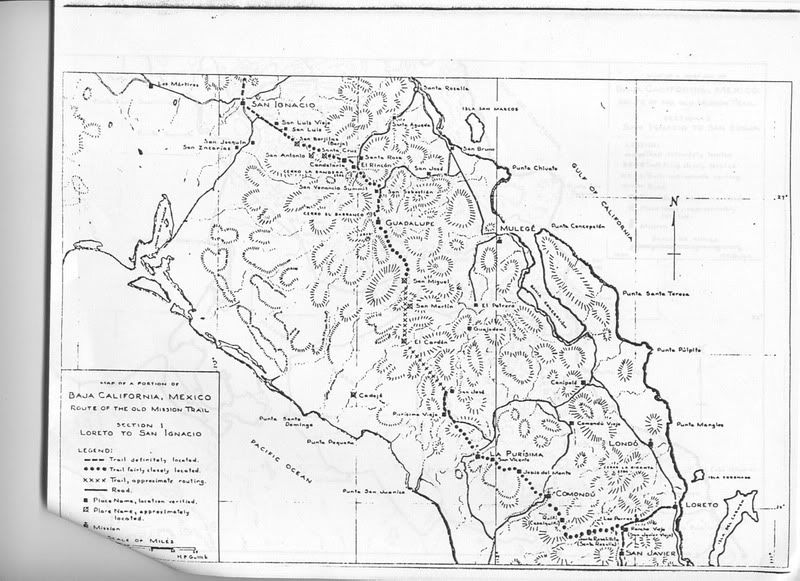
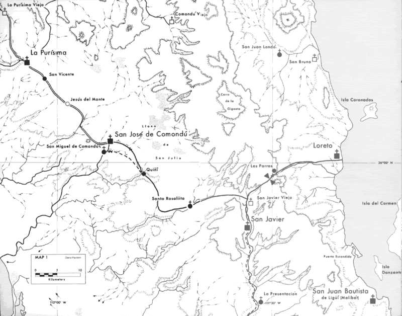
LORETO TO COMONDU
From the first California mission of LORETO to the second, Mision San Francisco Javier, the mission trail utilized the canyon of LAS PARRAS to the
first site of Mision San Javier which today is called RANCHO VIEJO. The modern auto road is built in the same canyon.
One tenth of a mile west of RANCHO VIEJO the Camino Real splits. To the left (south) goes the trail to SAN JAVIER (5.5 mi.). To the right (west) the
Camino Real heads for Comondu and beyond.
On the Camino Real, 1.0 mi. from RANCHO VIEJO the old trail is joined by the Comondu auto road coming from the Loreto-San Javier road (junction at 1.0
mi. past Rancho Viejo).
2.2 mi. from Rancho Viejo another trail joins in from the south. This was the direct Camino Real from San Javier to Comondu, branching from the
Loreto-San Javier trail at EL HORNO (Los Hornos in the Almanac). This small triangle of trails shows the Jesuits built many roads to offer direct
routes, much like modern highways.
4.0 miles from Rancho Viejo, the Camino Real turns left from the Comondu auto road and follows ARROYO SANTA ISABEL.
EL PALMARITO is just south of the Camino Real which goes to a visita (visiting station) of San Javier known as Santa Rosalia (renamed Santa
Roasalillita). A stone chapel ruin remained in 1955. Santa Rosalillita is not shown in the Almanac, but the Camino Real is. The old trail goes
westerly for about 5 miles from the edge of the map (just above El Palmarito), then turns almost to the north and goes to QUIñI.
The original Camino Real continued north from Quiñi and reaches SAN MIGUEL COMONDU.
When the newer mission of SAN JOSE COMONDU was moved to just north of San Miguel, the Camino Real was re-alligned at Quiñi to go more directly to San
Jose Comondu passing between CERRO CAPI and CERRO COLORADO.
The original Jesuit Camino Real left the Comondu valley at SAN MIGUEL (de Comondu). However, after that mision was closed in 1737 and moved
to/absorbed by the relocated SAN JOSE de COMONDU (just two miles away), the "King's Highway" was also moved.
---------------------------------------------------------------------------
COMONDU TO LA PURISIMA
From SAN JOSE COMONDU the trail first went to EL PABELLON and a modern graded dirt road was built on or near the mission trail in this section.
The trail passes just south of a peak named CERRO JESUS DEL MONTE. Jesus del Monte was an important point on the old trail because of a large tinaja
(water hole) about 20 feet by 60 feet in size. This spot became a visita of the mission at Comondu and a cut stone chapel was still visible and
photographed by Crosby, 30 years ago.
The name 'Jesus del Monte' was derived form a natural formation on a near-by volcanic cinder cone that resembled Jesus and the cross to early
travelers.
The next point on the old trail is EL RENEGADO then the trail passes along the east side of CERRO TEZONTLE, a mountain once mined for porous building
stone that was highly esteemed.
The next place name on the original Baja road was a little oasis called SAN VICENTE.
When Harry Crosby arrived at Rancho San Vicente he was made welcome by Maximiliano Arce and presented with fruit from Arce's orchard. One fruit that
was interesting was the 'limon real' (royal lemon), a pear shaped citrus that appeared to be a hybrid of lemon and grapefruit.
From San Vicente the Camino Real continued to LA PURISIMA and dropped into that valley via switchbacks, that can still be seen.
----------------------------------------------------------------------------
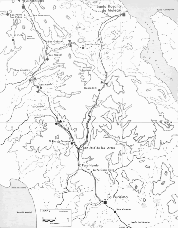
LA PURISIMA TO GUADALUPE
The Camino Real leaves La Purisima to the north, climbing directly out of the canyon and crosses MESA LAS MESAS then decends in ARROYO PURISIMA VIEJA.
The old trail was badly erroded when Crosby travel here, 30 years ago. But, it can be seen where it joins the Paso Hondo automobile road about 7 miles
northwest from San Isidro.
PURISIMA VIEJA was the original site of the mission La Purisima Concepcion. The Jesuits tried to locate their missions close to Indian villages
('rancherias'), but often the water source, which was enough for drinking, was not large enough for also growing crops, so a new site was established.
PASO HONDO and SAN JOSE DE GUAJADEMI (San Jose de los Arces) is on the Camino Real. At San Jose, the trail has a major junction.
The oldest route went right (northeast) directly for Mulege, near the gulf. In the 1760's, most travelers used a new route that took the Camino real
northwest along ARROYO AGUA VERDE and headed for the mission of Guadalupe, in the mountains.
ARROYO LAS CHIVAS is reached and where the Camino Real continues north, another trail (traveled by Crosby) makes a slight detour and goes to EL
REPARITO, LAS CHIVAS, EL TULE, LA VINORAMA and rejoins the old camino at SAN MARTIN.
The next section goes over a ridge to ARROYO SAN RAYMUNDO then upstream to SAN MIGUEL, a major visita of Mision Guadalupe. Ruins are still visible at
San Miguel.
SAN ESTANISLAO and SAN JUAN are along El Camino Real as it continues northward, finally arriving at MISION GUADALUPE (1720-1795).
From the diary of Fr. Junipero Serra, 1769
On the Camino Real, between La Purisima and Guadalupe, Serra had an interesting encounter...
"I met there with about ten Indian families: men, women, boys and girls. When I asked them what they were doing there, they answered, with much
sorrow, that they belonged to the Guadalupe Mission, not to any particular rancheria, but to the principal village, and that the Father, for lack of
food, had been forced to send them to the mountains to look for food, and that, not being used to that way of life, they had no success."
"They suffered very much, especially at seeing their babies starve and hearing them cry..."
Serra provided relief with his supply of ground corn from which he prepared 'atole'. He then instructed the families to return to Guadalupe, as he was
aware a supply ship had arrived at Mulege for Mision Guadalupe's needs.
They thanked the good Father by singing a hymn about the love of God, Serra found very touching.
---------------------------------------------------------------------------
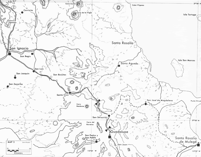
GUADALUPE TO SAN IGNACIO
From the mission of Guadalupe, the Camino Real heads north over a cuesta (grade) and drops into ARROYO SAN SEBASTIAN.
SAN SEBASTIAN (shown west of its true location) is/was on the Camino Real where Arroyo San Sebastian joins ARROYO BOCA DE MAGDALENA. Here, the old
trail turns west and follows the new arroyo upstream.
Rancho EL GATO is on the old trail where it turns to the northwest and heads to the grade known as Cuesta de San Venancio. Named by Padre Lizasoain in
1762, its summit is 3,500 feet high and offers the most 'magificent view', per Harry Crosby. The Jesuit road was heavily overgrown, but offered the
best preserved switchback grade of the entire El Camino Real, Harry writes. A newer trail is seen going north to EL RINCON.
LA HIGUERA and LA CANDELARIA are the next two ranchos on the old trail, the second operated by the Villavicencio brothers (Anastasio, Juan and
Francisco) when Crosby rode here.
The Camino Real climbs another cuesta and drops into ARROYO SANTA CRUZ, following it northwest to SAN LUIS and on to SAN IGNACIO.
------------------------------------------------------------------------------
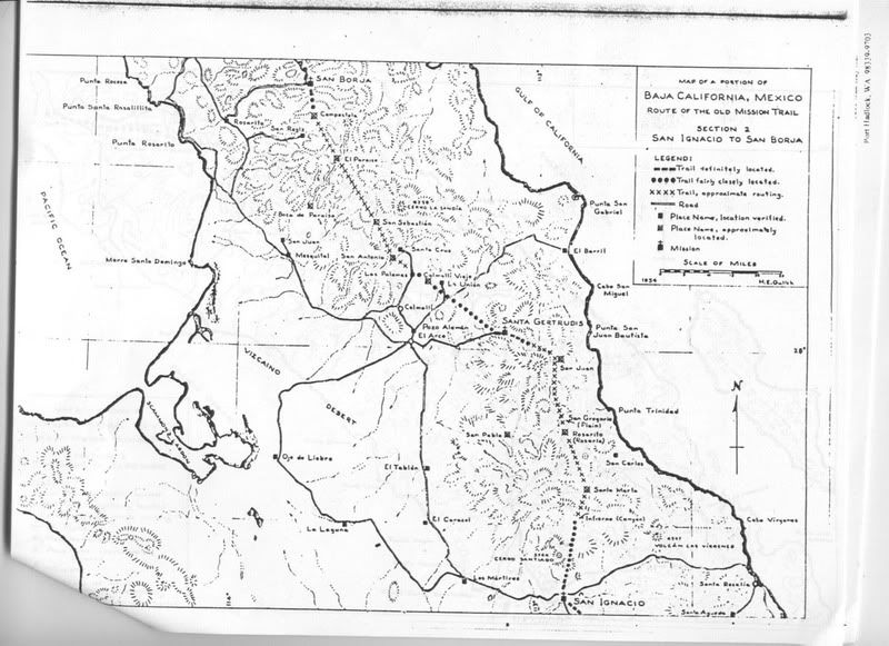
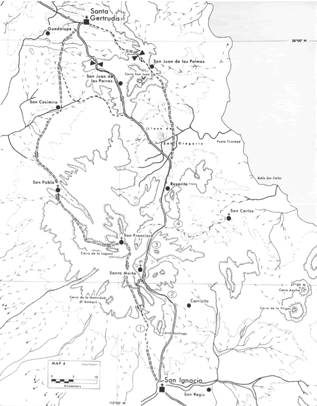
SAN IGNACIO TO SANTA GERTRUDIS
Two major routes were used as El Camino Real north from San Ignacio. One kept to the Pacific side of the Sierra San Francisco and the other, on the
gulf side. Perhaps one was used in the hot months and the other in the cooler months. Or, it depended on which visita needed a visit?
The Pacific Side Camino Real leaves San Ignacio going slightly west of true north and drops into ARROYO SATANCIO following it up into the mountains.
Arrive at SAN FRANCISCO DE LA SIERRA, once a visiting station of San Ignacio and perhaps an early choice for the next planned mission to the north (to
be called 'Dolores del Norte').
Ruins of the old chapel walls were identified as 'Dolores' to the first outsiders (Choral Pepper and others with the Erle Stanley Gardner sponsored
helicopter expedition of 40 years ago).
From tiny San Francisco, the Camino Real goes west then northwest, finally dropping down into San Pablo Canyon to the visita of SAN PABLO.
From the visita, continue down ARROYO SAN PABLO to (just past) the first MESA SAN PABLO, where it climbs to the north and goes straight to SAN
CASIMIRO. From there it heads straight north.
After crossing the 28° parallel, the ECR curves to the northeast and soon reaches Santa Gertrudis.
-----------------------------------------------------------------------------
The Gulf Side Camino Real is shown in the Almanac leaving San Ignacio straight north, veering east of CERRO SANTIAGO and dropping into ARROYO EL
INFIERNO, and follows it upstream.
SANTA MARTA was a visita and a resting place for Serra and others on the Camino Real. Continue north into ARROYO EL ROSARITO to the flat plain of SAN
GREGORIO. Here Crosby comments on how nowhere had the road (ECR) been so wide, straight, and clearly marked.
One of the El Camino Real routes goes almost to SAN CASIMIRO then turns north to EL CARRIZO, joins with the Pacific Side ECR and reaches Santa
Gertrudis.
A far east route goes from ARROYO SAN GREGORIO north through SAN JUAN DE LAS PARRAS, then swings westward and follows ARROYO SANTA GERTRUDIS to the
mission.
------------------------------------------------------------------------------
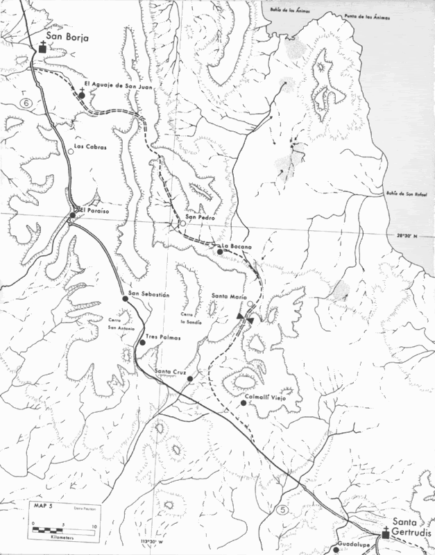
SANTA GERTRUDIS TO SAN BORJA
As in the previous section (San Ignacio to Santa Gertrudis), more than one trail was the Camino Real. This first description will be the route
traveled by Serra (probably) and Harry Crosby, known as the 'Paraiso route' by Howard Gulick.
The old camino goes straight northwest from Santa Gertrudis to RANCHO LA UNION then just west of MESA CALMALLI VIEJO and MESA SANTA CRUZ to RANCHO
TRES PALMAS.
The trail from Tres Palmas was sandy as it follows the ARROYO SAN SEBASTION (called Arroyo Tres Palmas by Crosby), but becomes rocky as it climbs up
the sierra to RANCHO SAN SEBASTION.
The Camino Real again climbs and goes through a pass just west of San Sebastion then follows the west edge of Arroyo San Sebastion on a mesa where
Crosby reports a grand view back to Scammon's Lagoon.
EL RANCHO is reached, seen on the edge of the map. EL RODEO is the next place mentioned by Crosby and the trail next reaches the edge of the great
canyon of ARROYO PARAISO.
The Camino Real was steep where it dropped off the mesa and required an hour of rock moving by Crosby and company to rebuild washed out portions. They
reached the bottom and traveled up the canyon to RANCHO EL PARAISO.
A quarter mile beyond Rancho El Paraiso is the grade to the top of the north side of the canyon. LAS CABRAS then COMPOSTELA are passed as this route
of the Camino Real goes north to reach MISION SAN BORJA.
-----------------------------------------------------------------------------
The other routes are known as the 'Pacific' and the 'Gulfo Camino'...
The Pacific route stayed out of the high sierra until turning east to pass through the visita of SANTA ANA and on to San Borja.
The Gulfo Camino was partly traveled by Arthur North, around 1905. It branches from the Paraiso route near CALMALLI VIEJO, passes CERRO EL VALLE going
north-northeast to VALLE LA BOCANA. Along the way was an important tinaja (water hole) called Santa Maria. We visited Tinaja Santa Maria in 2001 and a
year and a half later: http://vivabaja.com/1202/page2.html.
From La Bocana, the Gulfo Camino travels up VALLE SAN PEDRO and crosses the mountain ridge just south of the 28°40' line.
The water hole EL AGUAJE is passed (see photos of it at http://vivabaja.com/neal/page4.html) as is RANCHO SAN GREGORIO (see photos at http://vivabaja.com/401/page5.html on the way to Mision San Borja.
-----------------------------------------------------------------------------
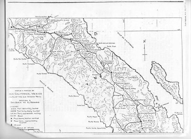
SAN BORJA TO CALAMAJUE
Unlike most of the previous sections of the old mission trail, much of the route north of San Borja is near auto. roads. Photos and GPS by Neal Johns
and I can help you find parts of this trail, which was the 'Baja highway' before automobiles!
Unfortunately, the good road builders (who were the Jesuits) were removed from California by orders of the king not long after pushing north from San
Borja. They hadn't the time to construct the Camino Real to the standards of the southern sections. The Franciscans only did some 'cargo' trail
building between Mision Santa Maria and Gonzaga Bay as it was necessary for their Alta California project. As a result, most of the Camino Real north
of San Borja resembles little more than a cattle trail, today.
From San Borja the old trail and modern road are basically the same for the first few miles then the ECR passes just west of CERRO COLORADO DE SAN
BORJA, whereas the auto road swings more west.
Neal believes he found where it rejoins the auto road, see a photo near the trail of Neal driving 'through' a boojum tree! http://vivabaja.com/neal2/page4.html
North of the above photo location, the Camino Real turns west to pass through CANON EL JARAZO, then north between ARROYO AGUA AMARGA and ARROYO VERDE
and crosses the L.A. Bay highway at the Kilometer 30 Marker.
Highway construction in 1974 obliterated the trail on either side of the new road, but a short hike will reveal it. I found what I believe to be the
ECR, to the south at http://vivabaja.com/703.
On the north side of the L.A. Bay highway, the Camino Real turns from north to northwest, at the base of a hill. See my photo at http://vivabaja.com/403/page13.html
Now, the Camino Real heads to Tinaja de Yubay, via CANADA BENTANCOURT going northwest, and along the east side of MESA LUZ DE MEXICO.
The famous tinaja (water hole/ pond), it is in ARROYO YUBAY midway between CERRO LA PALMITA and MESA YUBAY.
The Camino Real travelers had to take a short detour up the Yubay canyon to reach the water. Neal Johns has the GPS for a few points on the old trail,
at the bottom of http://vivabaja.com/neal2/page5.html. Also, Neal has great photos of Yubay starting at http://vivabaja.com/neal2/page2.html.
Continuing northwest, the El Camino Real follows the base of the SIERRA LA ASAMBLEA, east of EL CRUCERO at Highway One.
Inside CANADA AGUAJITO HIGUERAS was a water source for early travelers. The old trail comes to or crosses the auto road going to CALAMAJUE. Here, they
are parallel until they enter Calamajue Canyon where they merge, as no other route is possible, in the narrow, water filled canyon.
Where the auto road climbs a steep grade to leave the Calamajue river (heading for Coco's Corner and Gonzaga), the trail and road to the mission head
to the opposite side of the arroyo and up to a terrace overlooking the valley.
----------------------------------------------------------------------------
CALAMAJUE TO SANTA MARIA
In 1769, Junipero Serra left Calamajue a little after noon and arrived at 'San Francisco' (San Francisquito) that day.
The name San Fancisquito had been applied to many sites in the region, including the larger part of what most call 'Gonzaga Bay': Ensenada de San
Francisquito. The Mexican topos and Baja Almanac switched the names of the two halves of 'Gonzaga Bay', however.
From the water hole (and later an abandoned mining camp) of San Francisquito, the old trail follows the arroyo of San Francisquito, but called ARROYO
LAS ARRASTRAS in the Almanac. Crosby notes seeing excellent signs of the Jesuit road higher and on the west side of the arroyo from the auto road.
Both Gulick and Crosby say the Camino Real follows the arroyo to its junction with ARROYO SANTA MARIA, however recent mule back Camino Real traveler,
Baja Bucko, says the trail short cuts to the mouth of the Santa Maria canyon and passes the palm oasis of Las Palmitas at 29°40.35'/ 114°28.29° Some
excellent photos of this oasis are at http://www.timsbaja.com/jan03trip/jan03trip3.html.
From Las Palmitas (also spelled: Las Palmytas or Las Palmas) the trail heads for the mouth of Santa Maria canyon...
Junipero Serra and likely the Jesuits before, went right up the canyon, called 'El Cajon' and climbed up the steep north side to enter the valley
containing the mission. This trail is now called the 'Indian Trail' as the El Camino Real was moved out of the canyon after Serra's trip to Alta
California. The Indian trail is visible in this aerial photograph (bottom photo): http://vivabaja.com/missionsm/page6.html.
This 'El Cajon' canyon route was so dangerous that a new route was established which stayed out of the canyon, to the north. This was the route
traveled on mule by Crosby, Baja Bucko, and Don Jorge.
Photos of the Camino Real where it leaves Arroyo Santa Maria at 29°41.733'/ 114°28.175' and heads northwest are at: http://vivabaja.com/1102/page6.html.
Santa Maria de los Angeles (located midway between Catavina and Gonzaga Bay's Punta Final) was the last mission founded by the Jesuit order, in 1767.
They built a chapel from palm logs before being expelled from California by order of the king of Spain. The Franciscans replaced the Jesuits, and
built the adobe church and residence structure whose ruins are viewed today. See http://vivabaja.com/missionsm for photos by Neal Johns and Baja Mur. The most recent trip was in 2010: http://vivabaja.com/msm2010/
Franciscan padre, Junipero Serra had a cargo trail constructed from Santa Maria northeast to Bahia San Luis Gonzaga. Remains of a warehouse built by
the padres are still visible: http://vivabaja.com/1102/page4.html At Gonzaga Bay, supplies were off loaded from ships to supply Santa Maria and subsequently the first
Franciscan mission in California, San Fernando Velicata.
Santa Maria was abandoned as a mission in 1769, but continued as a visiting station and rest stop on the El Camino Real.
----------------------------------------------------------------------------
SANTA MARIA TO SAN FERNANDO
From Santa Maria, the auto road and trail took the same path to the peninsular divide: http://vivabaja.com/403/page3.html. There-abouts, the ECR went more northerly to a water hole known as San Antonio, then northwest to a spring
called San Nicolas, located on the upper portion of Arroyo Catavinacito (the arroyo that crosses Hwy. 1 north of Catavina, by the pictograph cave).
From San Nicolas the trail headed west to Agua Dulce, an important spring located just north of Highway 1, about 8 miles east of Rancho Sonora: http://vivabaja.com/1102.
From Agua Dulce the old trail and the old transpeninsular dirt road were very near each other, except that the El Camino Real went to the south of
Rancho San Agustin (as does Hwy. 1).
It should be noted that the Mexican topo maps (and pre 2009 Baja Almanacs) never plotted the new highway correctly and just 'paved' the old road (on
the map) in the section from near San Agustin to San Roque. The highway actually parallels the old road, about 1-2 miles to the south and west of it.
The Camino Real parallels ARROYO SAN FERNANDO west from near San Agustin, as does Highway One.
Today's Rancho Progreso cafe is a half mile north of the old Baja road and ECR route, where that rancho used to be. It is then about 3 miles west
along Arroyo San Fernando to Mision San Fernando Velicata.
Mision San Fernando Velicata was the first Franciscan founded mission in California in 1769 (and the only one in Baja). Junipero Serra found the site
to be much more suitable than arid and limited Santa Maria de los Angeles, the final Jesuit mission (in California).
Another water source on the old trail...
Among the beautiful photographs from Neal Johns, the bottom one at http://vivabaja.com/neal2/page5.html showing the oasis in ARROYO AGUAJE GUILLERMO may very well be a place named 'Agua Escondida' by Arturo Grosso
to Howard Guilick, in the 1950's.
This 'Agua Escondida' was between San Nicolas and Agua Dulce on the Camino Real. Gulick's 1954 map of the El Camino Real places this spring in the
same arroyo where Neal's photo was taken.
-----------------------------------------------------------------------------
SAN FERNANDO TO EL ROSARIO
The next section (to El Rosario) is quite different from the old or new transpeninsular roads!
Junipero Serra's route north to San Diego bypassed El Rosario (the next mission, founded 5 years later) and instead went north past San Juan de Dios
and into the lower foothills of the Sierra San Pedro Martir not returning to the coastal plain until the San Telmo/ Colonet region of today.
Harry Crosby's book (GATEWAY TO ALTA CALIFORNIA) is a superior guide to Serra's exact route from El Rosario to San Diego.
The Camino Real to the next mission (Rosario, founded by the Dominicans in 1774) traveled west from San Fernando.
Where the arroyo bends south at the base of the petroglyph cliff, the old trail went into the small canyon just to the right/north of that cliff and
continued west.
The next point on the Camino Real was a water hole called SANTA URSULA. Howard Gulick drove to Santa Ursula in 1953. The road to it is 2.0 miles west
of (now gone) Rancho Arenoso, on the old main road. Rancho Arenoso was just south of the highway at Km. 106 (west the the bridge named Arenoso I), the
ruins were visible from the pavement for many years, some still are.
Going south to Santa Ursula, 6.9 miles from the old main road, Gulick found an old adobe house, remains of an old dam and an irrigation ditch.
The next water hole was called AGUA AMARGA and is located on ARROYO SAN VICENTE, probably close to the merging with ARROYO LA BURRA. Another water
hole called LAS CUEVITAS was beyond Agua Amarga.
The Camino Real turns north up ARROYO EL SAUCE the turns west at about the 30° line of latitude passing the north side of MESA LA SEPULTURA and
crosses the Punta San Carlos road just south of Highway One. Near the Punta San Carlos road, just south of Hwy. 1, I found it: http://vivabaja.com/1104/page5.html
A place called SAN ANTONIO was on the old trail. Continue west to the older road going from El Rosario to Punta San Carlos, which was reached about 5
miles southwest from El Rosario. The Camino Real and that auto road took the same route on to El Rosario.
-----------------------------------------------------------------------------
From El Rosario north to Alta California both Highway One and El Camino Real were mostly parallel and close together. Exceptions would be were the ECR
went inland via Mision Santo Domingo and San Telmo de Arriba, staying in the foothills between San Quintin to just north of Colonet. Also, San Vicente
to Santo Tomas was partly west of Highway One.
Enjoy exploring Baja as much as the pioneers of the past and the adventurers of today!
MAPS in the next part...
|
|
|
David K
Honored Nomad
Posts: 64478
Registered: 8-30-2002
Location: San Diego County
Member Is Offline
Mood: Have Baja Fever
|
|
GUILICK'S 1955 MAPS:
CROSBY'S 1977 MAPS:
Highlighted onto the 2003 Baja Almanac folding map:
More detailed close up maps coming!
|
|
|
Ateo
Elite Nomad
Posts: 5847
Registered: 7-18-2011
Member Is Offline
|
|
WOW. Incredible. I'll digest this over a few hours tonight. What a gift. Thanks,
Jon
|
|
|
joerover
Banned
Posts: 676
Registered: 2-3-2011
Location: earth
Member Is Offline
Mood: sleepy
|
|
good work map man
the fat lady is breeding
which means
The fat ladys are breeding
|
|
|
Marc
Ultra Nomad
Posts: 2743
Registered: 5-15-2010
Location: San Francisco & Palm Springs
Member Is Offline
Mood: Waiting
|
|
This is great! Thanks!
|
|
|
Mexitron
Ultra Nomad
Posts: 3397
Registered: 9-21-2003
Location: Fort Worth, Texas
Member Is Offline
Mood: Happy!
|
|
Nice job David! Didn't know the ECR split below San Borja---must be quite a trail going to the east side of the divide around Pico
Echeverria---that's some rough country to cross over to the Gulf side.
|
|
|
David K
Honored Nomad
Posts: 64478
Registered: 8-30-2002
Location: San Diego County
Member Is Offline
Mood: Have Baja Fever
|
|
Yes indeed... and you can see much of it on Google Earth from space! Much more to come... later (I have an irrigation job today, yea!)
|
|
|
David K
Honored Nomad
Posts: 64478
Registered: 8-30-2002
Location: San Diego County
Member Is Offline
Mood: Have Baja Fever
|
|
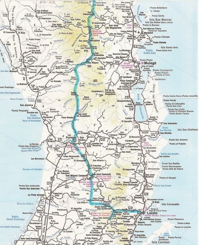
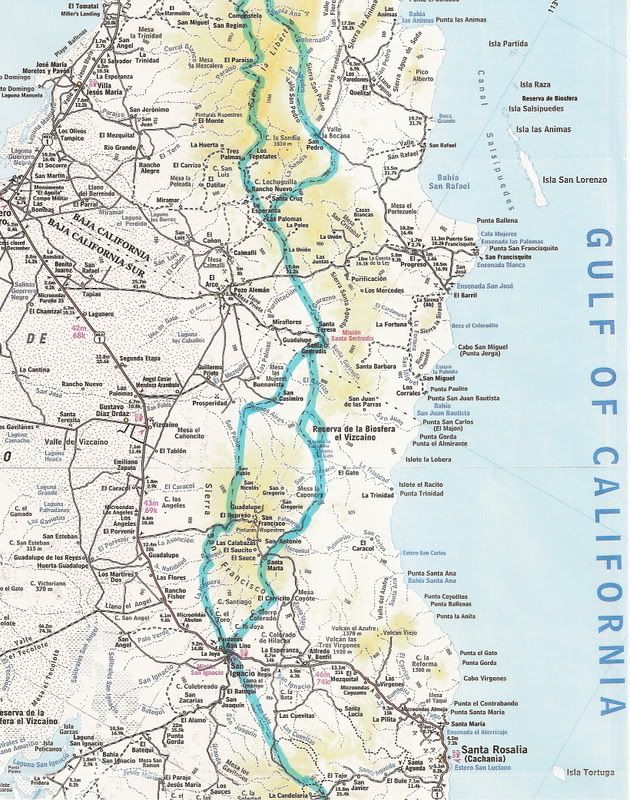
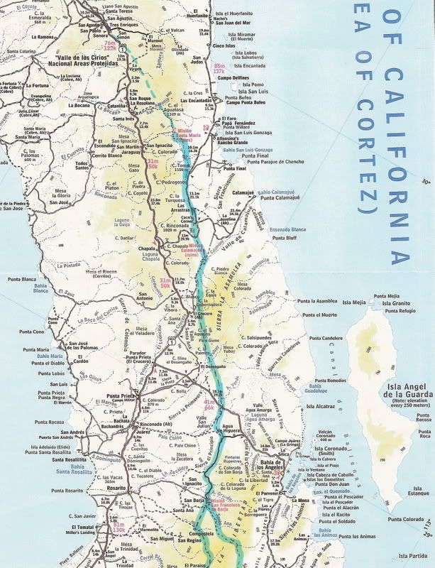
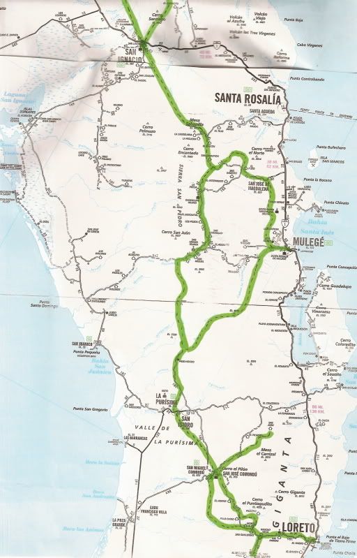
On AAA Map
Here is the El Camino Real approx. location highlighted onto the AAA map from Loreto to Santa Maria... but I will reverse the 3 maps so that north is
the the top:
[Edited on 11-17-2011 by David K]
|
|
|
David K
Honored Nomad
Posts: 64478
Registered: 8-30-2002
Location: San Diego County
Member Is Offline
Mood: Have Baja Fever
|
|
| Quote: | Originally posted by Mexitron
Nice job David! Didn't know the ECR split below San Borja---must be quite a trail going to the east side of the divide around Pico
Echeverria---that's some rough country to cross over to the Gulf side. |
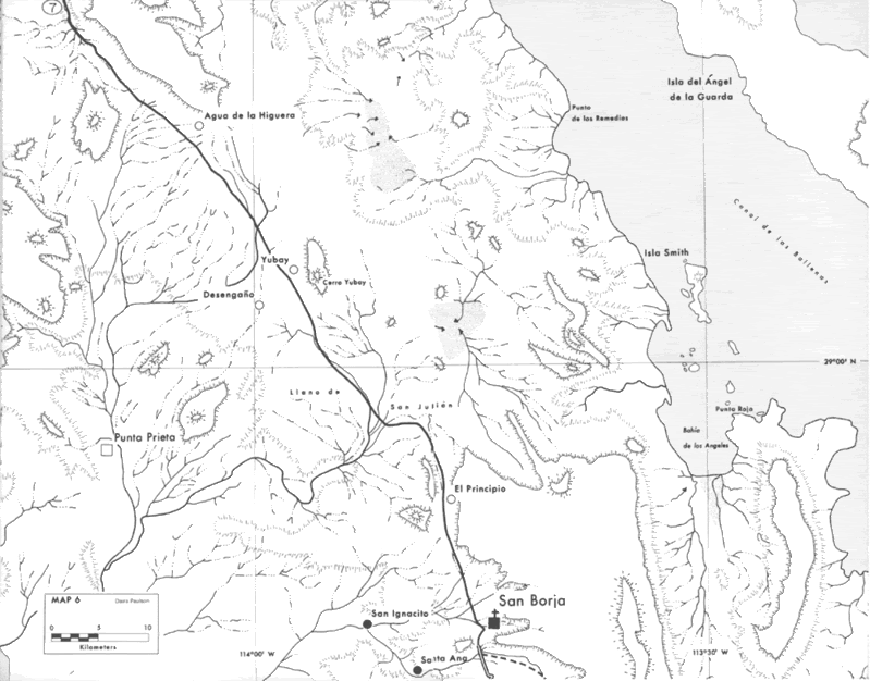
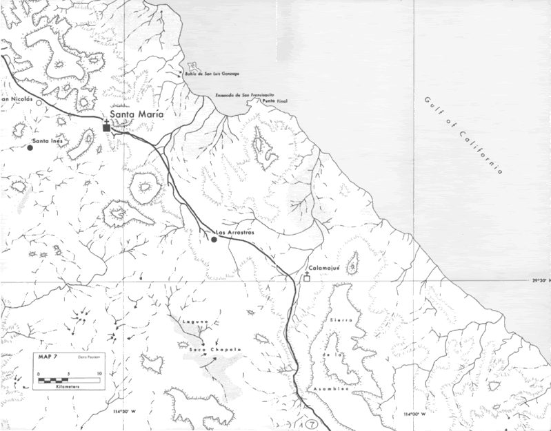
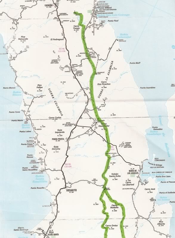
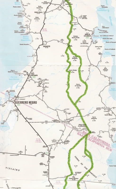
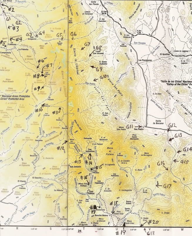
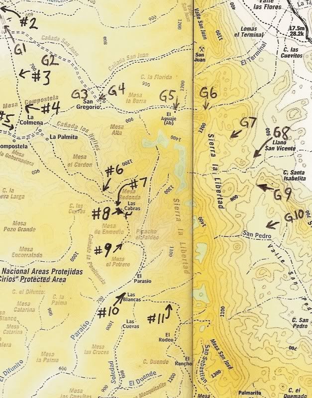
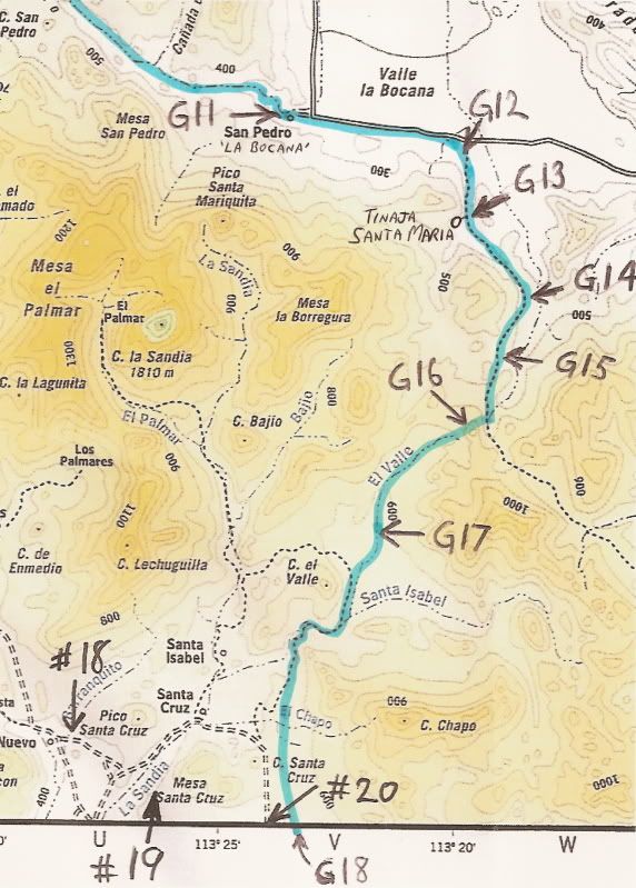
Steve, here is the detailed maps of the Golfo Camino Real between San Borja and Santa Gertrudis... The arrows drawn on them (G-1 to G-18) are points
where one can actually see the trail on Google Earth... An overview map first, followed by two close ups:
|
|
|
Mexitron
Ultra Nomad
Posts: 3397
Registered: 9-21-2003
Location: Fort Worth, Texas
Member Is Offline
Mood: Happy!
|
|
I know where the southern split is---I've been up that valley around Santa Cruz....big broad sandy wash---we went up it on our way up to Palomar and
the Pico Echeverria (La Sandia) area. Didn't realize there was such a low pass thru La Valle---I wanna go back and check it out! Still wanting to
climb la Sandia too. Really neat country in there. Thanks for the maps David!
|
|
|
David K
Honored Nomad
Posts: 64478
Registered: 8-30-2002
Location: San Diego County
Member Is Offline
Mood: Have Baja Fever
|
|
| Quote: | Originally posted by Mexitron
I know where the southern split is---I've been up that valley around Santa Cruz....big broad sandy wash---we went up it on our way up to Palomar and
the Pico Echeverria (La Sandia) area. Didn't realize there was such a low pass thru La Valle---I wanna go back and check it out! Still wanting to
climb la Sandia too. Really neat country in there. Thanks for the maps David! |
Very cool.. if there is a way, I would love to join you on any hike on the Camino Real or Pico La Sandia climb!
Here is a photo of La Sandia, the very sharp peak in the distance... as seen from Tinaja Santa Maria. My kids and I went to the Tinaja twice, this
photo was the second visit in December, 2002. My son is on his motor bike in the photo:

Tinaja Santa Maria was made famous in Arthur North's 1910 book, 'Camp and Camino in Lower California'. This was an important water source on the Gulfo
Camino Real.
|
|
|
Mexitron
Ultra Nomad
Posts: 3397
Registered: 9-21-2003
Location: Fort Worth, Texas
Member Is Offline
Mood: Happy!
|
|
Sounds like a plan David--I'm doing a quick trip to Arroyo Grande or Ruby Canyon in December with Brooks et al, then to Oregon to see my folks for
Xmas for a couple weeks-----so after Xmas the schedule is ready to be filled in with new Baja adventures! We might squeeze a surf trip to the Sisters
but a trip to La Sandia could happen until about late May when it might get too hot for comfortable exploring...
|
|
|
Fernweh
Nomad
Posts: 444
Registered: 2-24-2011
Location: Centenario, BCS
Member Is Offline
|
|
David,
is there anything left from/at
San Juan de las Palmas?
Do you have the coordinates of that site for me? Next time I visit El Gato again, I like to find San Juan on the camino real.
Thanks,
Karl
|
|
|
David K
Honored Nomad
Posts: 64478
Registered: 8-30-2002
Location: San Diego County
Member Is Offline
Mood: Have Baja Fever
|
|
| Quote: | Originally posted by Fernweh
David,
is there anything left from/at
San Juan de las Palmas?
Do you have the coordinates of that site for me? Next time I visit El Gato again, I like to find San Juan on the camino real.
Thanks,
Karl |
I will see if I can find something for you...
I believe Bill Nichols and others rode their M/Cs through there... If you are into these remote spots, specially by dirt bike, get Kacey Smith's great
GPS Baja Guides: http://www.bajagpsguide.com
|
|
|
Fernweh
Nomad
Posts: 444
Registered: 2-24-2011
Location: Centenario, BCS
Member Is Offline
|
|
Thank you David,
I have been twice through that area from Hwy1 via Santa Martha to El Barril, with a 4x4 along the coast. I know we crossed the ECR at one point and
the great built road was in perfect, not modified at all over the last"few" years.
I'm sitting right now at the Cactus Motel in El Rosalia on my way south to La Paz.
No time to venture away from the Hwy, but there will be another time for Sur
Karl
|
|
|
David K
Honored Nomad
Posts: 64478
Registered: 8-30-2002
Location: San Diego County
Member Is Offline
Mood: Have Baja Fever
|
|
From almost 3 years ago:
This is when I was making the El Camino Real from Space thread on Nomad:
| Quote: | Originally posted by David K
Well... I spent a few hours yesterday and last night on the Gulfo route between Santa Gertrudis and San Ignacio (actually joins the Sierra route north
of El Rosarito).. and could not find a lot of convincing Jesuit road construction.
I found a lot of trail... and could piece it together from Santa Gertrudis to San Juan de las Palmas, just over the divide... Then, coming north from
El Rosarito, a trail can be followed to El Gato. But, from El Gato north to San Juan de las Palmas (las Parras on the topo) I have not seen an example
of typical Camino Real road construction.
So, for the moment, the overall map showing the ECR routes I have seen from space, doesn't need to be amended! |
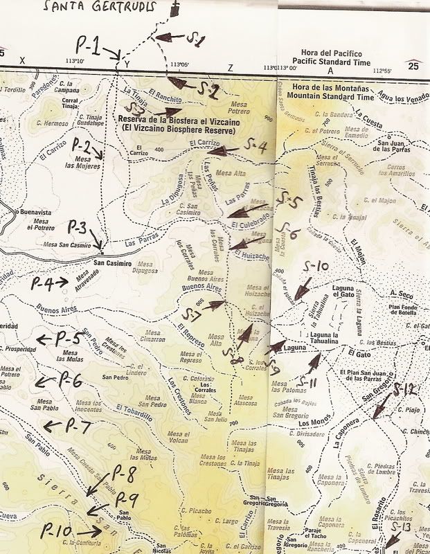
On this map, I have the Pacifico Camino Real and the Sierra Camino Real spotted with arrows... but the Golfo Camino Real between El Gato (to the east
of arrow S-11) and San Juan de las Parras (to the east of arrow S-4) I could not see from space images... so I did not locate that branch of El Camino
Real.
|
|
|
David K
Honored Nomad
Posts: 64478
Registered: 8-30-2002
Location: San Diego County
Member Is Offline
Mood: Have Baja Fever
|
|
| Quote: | Originally posted by Fernweh
David,
is there anything left from/at
San Juan de las Palmas?
Do you have the coordinates of that site for me? Next time I visit El Gato again, I like to find San Juan on the camino real.
Thanks,
Karl |
Just to be clear... since Harry Crosby's map is the only one that calls the rancho San Juan da las Palmas, as the Almanac calls it San Juan de las
Parras... (and Harry places a S.J. de las Parras on the Sierra Camino Real). Which rancho are you refering to?
|
|
|
David K
Honored Nomad
Posts: 64478
Registered: 8-30-2002
Location: San Diego County
Member Is Offline
Mood: Have Baja Fever
|
|
Anyone have an area of interest somwhere on the Camino Real... Need a close up map or satellite view of it, etc.?
|
|
|
Mexitron
Ultra Nomad
Posts: 3397
Registered: 9-21-2003
Location: Fort Worth, Texas
Member Is Offline
Mood: Happy!
|
|
David---when you visited Tinaja Santa Maria did you go explore further up the Valle San Pedro to the north? Wondering if there's a road up there to
explore---looks like an interesting place.
|
|
|
David K
Honored Nomad
Posts: 64478
Registered: 8-30-2002
Location: San Diego County
Member Is Offline
Mood: Have Baja Fever
|
|
| Quote: | Originally posted by Mexitron
David---when you visited Tinaja Santa Maria did you go explore further up the Valle San Pedro to the north? Wondering if there's a road up there to
explore---looks like an interesting place. |
The Tinaja de Santa Maria is in a small canyon over the ridge from the Valle San Pedro entrance from Valle La Bocana. The rancho that is called San
Pedro in the Almanac is actually Rancho La Bocana (as shown on Harry Crosby's map).
See my pictures there in 2003: http://www.vivabaja.com/403/page12.html
There was also a Jeep pickup with a TRICK racing fuel sticker in there, but nobody around. Trick Racing Fuel was the creation of BajaNomad's dad, fyi.
I drove up the road past La Bocana ranch into Valle San Pedro looking for some signs of the El Camino Real... after a couple miles, we turned back.
The Tinaja Santa Maria is reached via cross country driving up the arroyo... from the old road to San Francisquito, east of the La Bocana ranch road
junction. I provided the GPS waypoints for getting there on my web page of our first time in (2001), http://vivabaja.com/van1/page10.html
The second time in, the tracks were still visible from 1.5 years before: http://vivabaja.com/1202/page2.html
GPS DIRECTIONS: L.A. BAY & SOUTH (WGS 84)
Casa Diaz, Bahia de los Angeles: N28º56.77' W113º33.55'
Camp Gecko, south of town: N28º54.05' W113º31.73'
Las Flores (jail house): N28º49.10' W113º31.77'
Jcn. with old road south: N28º40.77' W113º25.45'
Arroyo to Las Venecas: N28º39.40' W113º25.86'
Site of Paredones, Jesus' ranch: N28º36.81' W113º24.59'
Road ahead to La Bocana & San Pedro, turn sharp left (east): N28º28.40' W113º23.47'
We turn right, off road here: N28º28.01' W113º20.46'
Tinaja de Santa Maria: N28º26.09' W113º20.02'
[Edited on 11-24-2011 by David K]
|
|
|
| Pages:
1
2 |
|