BajaNomad
Not logged in [Login - Register]

Go To Bottom
Printable Version  
 Pages:  1    3
Author: Subject: New Years 2012: Clams, both fresh & petrified! 5 photos from Tunaeater added!
TMW
Select Nomad
*******


Posts: 10659
Registered: 9-1-2003
Location: Bakersfield, CA
Member Is Offline


[*] posted on 1-11-2012 at 12:24 PM


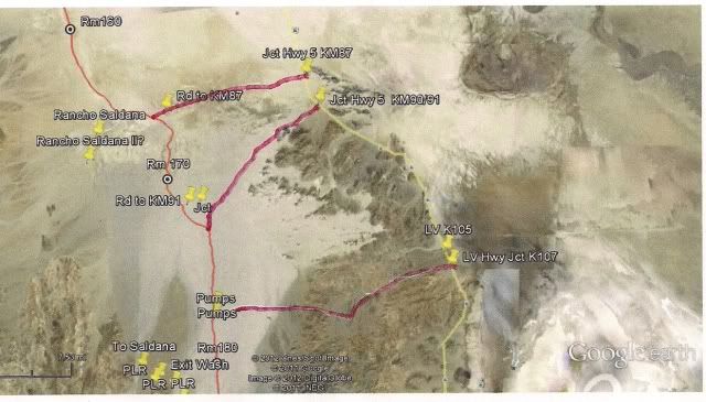
David, Ken and I have come out to hwy 5 two ways after his Pole Line Rd runs. One is to go north to Saldana as shown on the map and out ot KM87. The other is to go south/east to Arroyo Grande back to the wells and northeast and out to KM 91. The turn off on hwy 5 south of La Ventana that leads to the water pipe road is at KM 107+/-. The Google map below has the Baja 500 course with the access roads to Hwy 5.

View user's profile
David K
Honored Nomad
*********


Avatar


Posts: 64490
Registered: 8-30-2002
Location: San Diego County
Member Is Offline

Mood: Have Baja Fever

[*] posted on 1-11-2012 at 12:32 PM


The K107 to water well then south in Arroyo Grande to the Pole Line Road, where the Score Road leaves Arroyo Grande is what we drove.

I guess Ken left the Pole Line Road for Ejido Saldaña before it dropped down to Arroyo Grande? Anyway, our quest was to go into Arroyo Grande Canyon south of the Pole Line Road crossing, but a big steel cable was stretched across the arroyo just south of where the Pole Line/ Score road leaves the wash to head for Borrego Wash.

Thanks.


"So Much Baja, So Little Time..."

See the NEW www.VivaBaja.com for maps, travel articles, links, trip photos, and more!
Baja Missions and History On Facebook: https://www.facebook.com/groups/bajamissions/
Camping, off-roading, Viva Baja discussion: https://www.facebook.com/groups/vivabaja


View user's profile Visit user's homepage
TMW
Select Nomad
*******


Posts: 10659
Registered: 9-1-2003
Location: Bakersfield, CA
Member Is Offline


[*] posted on 1-11-2012 at 12:47 PM


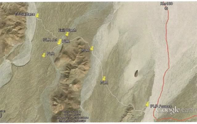
Here is the two routes from the PLR. One to Saldana and the other to Arroyo Grande.

View user's profile
David K
Honored Nomad
*********


Avatar


Posts: 64490
Registered: 8-30-2002
Location: San Diego County
Member Is Offline

Mood: Have Baja Fever

[*] posted on 1-11-2012 at 12:53 PM


Right... the bottom right of your map (PLR Access) we drove past and then out of the wash on the red line. We were looking for the old road back to La Ventana access as shown on the Gulick map. We found it, but it disappeared soon. We were wanting to avoid the slow whooped up race course in Arroyo Grande back to the well.

Have you driven south of there into the Arroyo Grande Canyon?


"So Much Baja, So Little Time..."

See the NEW www.VivaBaja.com for maps, travel articles, links, trip photos, and more!
Baja Missions and History On Facebook: https://www.facebook.com/groups/bajamissions/
Camping, off-roading, Viva Baja discussion: https://www.facebook.com/groups/vivabaja


View user's profile Visit user's homepage
TMW
Select Nomad
*******


Posts: 10659
Registered: 9-1-2003
Location: Bakersfield, CA
Member Is Offline


[*] posted on 1-11-2012 at 12:56 PM


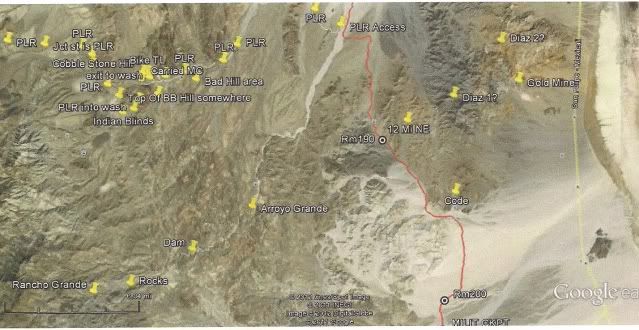
This shows the dam, rocks and Rancho Grande locations. I have been to the rocks. Google Earth does not show another way down Arroyo Grande that I could see to get around the cable.

View user's profile
David K
Honored Nomad
*********


Avatar


Posts: 64490
Registered: 8-30-2002
Location: San Diego County
Member Is Offline

Mood: Have Baja Fever

[*] posted on 1-11-2012 at 01:00 PM


It's sure fun exploring back in there. Pretty wild to think our boys built the Pole Line Road in 1942 through that land. Thanks Tom!


"So Much Baja, So Little Time..."

See the NEW www.VivaBaja.com for maps, travel articles, links, trip photos, and more!
Baja Missions and History On Facebook: https://www.facebook.com/groups/bajamissions/
Camping, off-roading, Viva Baja discussion: https://www.facebook.com/groups/vivabaja


View user's profile Visit user's homepage
David K
Honored Nomad
*********


Avatar


Posts: 64490
Registered: 8-30-2002
Location: San Diego County
Member Is Offline

Mood: Have Baja Fever

[*] posted on 2-28-2013 at 08:55 AM


Bump for Ateo


"So Much Baja, So Little Time..."

See the NEW www.VivaBaja.com for maps, travel articles, links, trip photos, and more!
Baja Missions and History On Facebook: https://www.facebook.com/groups/bajamissions/
Camping, off-roading, Viva Baja discussion: https://www.facebook.com/groups/vivabaja


View user's profile Visit user's homepage
Ateo
Elite Nomad
******


Posts: 5847
Registered: 7-18-2011
Member Is Offline


[*] posted on 2-28-2013 at 09:12 AM


Thanks DK. That picture looks pretty darn sandy. I guess if I air down with some speed and draw a good line I may make it. Hmmmmm.


View user's profile
David K
Honored Nomad
*********


Avatar


Posts: 64490
Registered: 8-30-2002
Location: San Diego County
Member Is Offline

Mood: Have Baja Fever

[*] posted on 2-28-2013 at 09:16 AM


Or stay close to the graded road where it ends by the giant diesel well (the end or start of the water pipeline from the gold mine)?


"So Much Baja, So Little Time..."

See the NEW www.VivaBaja.com for maps, travel articles, links, trip photos, and more!
Baja Missions and History On Facebook: https://www.facebook.com/groups/bajamissions/
Camping, off-roading, Viva Baja discussion: https://www.facebook.com/groups/vivabaja


View user's profile Visit user's homepage
David K
Honored Nomad
*********


Avatar


Posts: 64490
Registered: 8-30-2002
Location: San Diego County
Member Is Offline

Mood: Have Baja Fever

[*] posted on 12-4-2018 at 02:32 AM


Bump for wolfpack!


"So Much Baja, So Little Time..."

See the NEW www.VivaBaja.com for maps, travel articles, links, trip photos, and more!
Baja Missions and History On Facebook: https://www.facebook.com/groups/bajamissions/
Camping, off-roading, Viva Baja discussion: https://www.facebook.com/groups/vivabaja


View user's profile Visit user's homepage
PaulW
Ultra Nomad
*****


Posts: 3009
Registered: 5-21-2013
Member Is Offline


[*] posted on 12-4-2018 at 09:30 AM


PLR
After my first PLR trip Jan 28/2014, Henry, a San Felipe GPS expert, drove the road using an archived GPS track. His verbal description is drive from La Ventana to the wells, proceeded west to the Jaquegel drainage and drive up the drainage until he intercepted the route we all use. That track is documented and both Rich and I have it. I cannot access it for now. Anyway that track is not recommended due to difficulty compared to the other more commonly used tracks. That track is on my to do list.
View user's profile
David K
Honored Nomad
*********


Avatar


Posts: 64490
Registered: 8-30-2002
Location: San Diego County
Member Is Offline

Mood: Have Baja Fever

[*] posted on 12-4-2018 at 10:00 AM


Arroyo Grande and Jaquegel are parallel washes after they leave the hills and both head north towards Laguna Salada.
The Pole Line road climbs out of Jaquegel (where we camped on the 2015 trip and fixed the road there) goes north to the runway and construction camp where the Saldaña road turned left and the road to Arroyo Grande turned right. The new wells are in Arroyo Grande but the arroyo is much wider than the Howard Gulick map shows... that is why my adding the map and Baja 1000 route on the Gulick maps appears west of Arroyo Grande itself.


"So Much Baja, So Little Time..."

See the NEW www.VivaBaja.com for maps, travel articles, links, trip photos, and more!
Baja Missions and History On Facebook: https://www.facebook.com/groups/bajamissions/
Camping, off-roading, Viva Baja discussion: https://www.facebook.com/groups/vivabaja


View user's profile Visit user's homepage
David K
Honored Nomad
*********


Avatar


Posts: 64490
Registered: 8-30-2002
Location: San Diego County
Member Is Offline

Mood: Have Baja Fever

[*] posted on 10-15-2019 at 09:45 AM


So much to do in Baja... This was just a 3-day trip but it inspired so much more discussion.


"So Much Baja, So Little Time..."

See the NEW www.VivaBaja.com for maps, travel articles, links, trip photos, and more!
Baja Missions and History On Facebook: https://www.facebook.com/groups/bajamissions/
Camping, off-roading, Viva Baja discussion: https://www.facebook.com/groups/vivabaja


View user's profile Visit user's homepage
HeyMulegeScott
Senior Nomad
***


Posts: 690
Registered: 8-25-2009
Location: Orygone/Mulege
Member Is Offline


[*] posted on 10-22-2019 at 08:26 AM


Looked like a fun trip. I wish they still had those gas prices.


View user's profile
 Pages:  1    3

  Go To Top


All Content Copyright 1997- Q87 International; All Rights Reserved.
Powered by XMB; XMB Forum Software © 2001-2014 The XMB Group


"If it were lush and rich, one could understand the pull, but it is fierce and hostile and sullen. The stone mountains pile up to the sky and there is little fresh water. But we know we must go back if we live, and we don't know why." - Steinbeck, Log from the Sea of Cortez


"People don't care how much you know, until they know how much you care." - Theodore Roosevelt


"You can easily judge the character of others by how they treat those who they think can do nothing for them or to them." - Malcolm Forbes


"Let others lead small lives, but not you. Let others argue over small things, but not you. Let others cry over small hurts, but not you. Let others leave their future in someone else's hands, but not you." - Jim Rohn


"The best way to get the right answer on the internet is not to ask a question; it's to post the wrong answer." - Cunningham's Law


Thank you to Baja Bound Mexico Insurance Services for your long-term support of the BajaNomad.com Forums site.


Emergency Baja Contacts Include:

Desert Hawks; El Rosario-based ambulance transport; Emergency #: (616) 103-0262