BajaNews
Super Moderator

Posts: 1439
Registered: 12-11-2005
Member Is Offline
|
|
Destination Timbibiche 2005
http://www.rancholeonero.com/divertido/2005tim.html
By Roy Baldwin - Sr. Divertido - Magellan
February 21, 2005
It's Sunday, Feb. 13th, and I'm 2 days late for my annual mapping trip to the back roads of Baja. On Friday, Mother Nature sent a reminder that she
is still in charge, as the entire Baja peninsula was blanketed with a huge out-of-season rain storm, forcing me to wait a couple of days for the roads
to dry out a bit.
Yesterday brought clear skies and 80-degree temps. The magic of the sun turned many of the morning rain puddles into dried mud patches by evening,
bolstering my hopes that by tomorrow, I'll have no problems with the dirt roads. In fact, a number of the routes I plan to cover are notorious for
deep silt; hopefully the rains will have packed them down.
Several of my objectives this trip will be to map the shoreline road from Todos Santos north to El Coyote, make the run from Las Pocitas to La
Soledad, map the additional routes from Constitucion east to San Jose de la Noria, and finally make the run I've talked about for years - a trip out
to Rancho Timbibiche on the Sea of Cortes side.
Most people think I'm crazy for doing these trips solo, but in reality it's quite safe with all my communication toys. Sat phones, VHF, 2-meter, I've
got it all. Even though my Jeep is 35-years old, it's specifically rigged for the Baja. This journal is the ultimate companion, as writing all this
stuff consumes every spare moment.
Tomorrow is the only day with an itinerary, as nothing ever goes as planned. I want to finish mapping the back roads between Cabo and Todos Santos, a
task left uncompleted from last December's trip.
That being said, let's see what Loki, the Norse god of mischief, has in store for me this time.
DAY 1
Last night a fierce north wind ravaged the East Cape, but dawn broke this morning to a dead still calm, without a cloud in the sky. It's as if Mother
Nature was trying to make up for the delay she caused me.
As today's scheduled run consists of a mere 50 miles of trails, along with a couple of hours of pavement, there's no rush. By the time I'm ready to
depart, it's already over 80 degrees, and I banish my jacket to the clothes bag. Saying goodbye to my faithful companion of the last 31 years, Ranger,
the pancake-eating, woman-hating parrot; I'm on the road to Cabo at 9:30, first stopping for a Valentine's Day smooch from the love interest of the
moment, Ceci. That being done, my conscience is clear, so off to the land of dirt and cactus we go.
The run down to Cabo is uneventful, other than the gorgeous weather I've been blessed with. Here I am, driving down Highway 1 in an open Jeep, wearing
a t-shirt, shorts and sunglasses in the middle of February - eat your hearts out Northeasterners!
Getting to Cabo, I'm to take the old airstrip road north to Candelaria. Making the turn, I'm surprised to find the road paved, not what my map
indicates. The paving doesn't help, as the congested traffic can only move at a snail's pace. Finally nearing the airstrip, I'm greeted with the
first dirt road of the trip, and the Jeep responds enthusiastically to finally get it's tires dirty.
Quickly leaving civilization behind, the road starts out broad and flat, which soon turns to a narrow washboard track. My early worry about muddy
roads seems to be unfounded, as the road is dry and hard. Climbing into the foothills, you'd never know we're within 10 miles of a major metropolitan
tourist Mecca - even the cell phone has no signal.
Passing endless ranchos in the hills, The first goal is to get to the San Felipe road west of San Jose del Cabo. Making this connection, I can now
get to Cabo without ever using the highway. Doubling back, I eventually get to Candelaria. From there it looks like a short run west to Highway 19
and Todos Santos, but nothing is for sure in the Baja. Crawling down a steep, poorly graded road, I come across a broad arroyo running to the sea.
The only problem, it's solid washboard the whole way. After a bone-jarring run in the sand, I see the highway ahead, but there's a bridge over the
arroyo with no way for me to jump onto the pavement.
Traveling parallel to the highway, looking for an opening in the barbed-wire fence that separates the pavement from the cows, all the openings are
mired in deep mud, which I'd like to avoid. Continuing on, eventually I drop into a small rancho, just as the ranchero is unlocking his entrance
gate. After giving me the evil-eye for having dared venture onto his property, he opens the gate and motions me through as I give him my best
stupid-gringo wave.
Back on the highway (much to the Jeep's annoyance), it's about a half-hour trip to Todos Santos. Arriving about 3:30, this is really about as far as
planned for today, so after checking into a modest $25/night hotel, it's time for a shower and siesta. Later on, it's time to wander around the
village, looking for someplace to satisfy my gastronomical cravings. A couple of beers and an overpriced dinner later, It's back to the hotel for
lights out.
Today's statistics - 140 miles and 6 new waypoints for the map book.
DAY 2
As is always when staying in Todos Santos, it's coffee and breakfast at Cafe Brown - always a good choice. Sharing conversation with Sara, who's just
completed yoga training and is bemoaning her eminent return to Washington, DC, she's fascinated with my maps and stories. Passing along the web
address so she can read the rest of the adventures, all that's left is to gas up all the cans at the Pemex station. I'm hoping I'm carrying enough, I
might have over 350 miles of rough roads ahead before the next gas stop - we'll see.
On the road again, this is where the trip really begins. The first goal is to map the primary road to Meliton Albanez, a small village known for it's
agriculture. Two years ago I mapped a difficult little-used back road to there, and I'd sure like an easier route. Heading north on the beach road,
either this area got more rain than Cabo, or the ground is saturated - there's lots more mud puddles. Watching for the last turn inland with tracks,
I've soon found the trail I'm looking for, and soon roll on into Meliton. Looking to replenish my ice supply, I'm astonished to discover none of the
6 stores in town stocks ice. At the 7th and final store, the enterprising owner has a supply of baseball-sized packets of ice he makes himself.
Restocking the cooler and satisfied with my good fortune, it's off to El Conejo. I've been wanting to make this trip for years, as this will allow me
to get from Los Barriles to Mag Bay without ever needing to go on pavement.
Moving on, the road doesn't match my map book, giving me another opportunity to correct the published maps. In fact, the road I'm on is sometimes
miles from what's shown on the maps. The mud puddles are becoming more frequent - it seems that as soon as the tires finish flinging off the mud from
the last hole, here comes another one. Pretty soon I'm starting to look and feel like John Candy after the mud-wrestling scene in the movie Stripes.
Just as I'm getting back towards the beach, there's a monstrous mud hole blocking my path, with no bypass trail. I could blaze through it, but I'd be
cleaning up the muck for a week. Time to break out the shovel and partially fill it in, at least enough so I can ease on through it. About 20
minutes and a lot of sweat later, the task is complete - time to put this distraction behind me.
Dodging more mud holes for endless miles, in the distance I can see the ranch house at Arroyo Seco, our Baja 1000 vantage point. Reaching our
campsite, it's time for a drink and photo before making the last run to Conejo, about 18-20 miles from here. Merrily enjoying the scenery, I almost
run right off the road into the biggest washout I've ever seen. Examining the huge void, I know this isn't new, so somehow I've missed a bypass road.
Backtracking, I try every set of tracks, but they all lead to dead-ends. Finally, about a mile back, there's a well-used track leading inland, and
soon I'm resuming my quest in the right direction.
Rolling into Conejo about 4:00, I grab a photo, then continue north, looking for a calm camp spot behind the dunes, as there's a strong onshore
breeze. About a mile later, I see my spot. Pulling in, I see I'm not the first to camp here - there's a fire ring and leftover wood for me - muchas
gracias Setting up camp, there's some time to work on this journal before making dinner and starting the fire. But first, it's the arduous task of
removing all the mud and dirt which has enveloped me. Like little foreign vermin, they have permeated very orifice on me, eyes, ears, nose, mouth,
and private parts. In fact if I had to pee right now, I'd bet it would be brown. However, do not fear, the remedy for this pestilence is at hand, lots
of soap and water.
The evening brings a symphony - if one only stops to listen, the crackling of the fire, the pounding of the surf, the chirping of the crickets -
almost better than a Jimmy Buffett concert. A long-lost love once told me that each star in the sky represents an angel in heaven. If that is the
case, I'll sleep easily, knowing a billion angels are watching over me tonight.
Today's total - 89 tough miles and 12 new waypoints.
DAY 3
Nature's alarm clock is on the job, as just before dawn the wails of a pack of coyotes calls at me to get up. My eyes were working overtime last
night, trying to expel all the dirt they accumulated on yesterday's drive, as I get up with dirt balls the size of peas in the corners of my eyes. As
soon as its light enough, I eagerly prepare one of the greatest inventions of modern science - camp stove coffee. No rush today, last night's heavy
dew layer has left everything dripping wet. Might as well let the sun dry the camp before packing. After spam and eggs, I enjoy a last cup of coffee
while sitting on top of my wind break sand dune, watching the sea gulls wander up and down the beach.
Breaking camp, I'm surprised to find it's already 9:30 before I'm on the road. Today's plan is to follow the coast road about another 20 miles before
turning inland, through Santa Fe, then to Las Pocitas on Highway 1. Then there's a 40 mile run to La Soledad. From there I haven't a clue on where
I'm going. It all depends on how long the jaunt takes.
Cruising along, enjoying the scenery, I almost miss the turn to Santa Fe. The road immediately turns nasty, with deep ruts and lots of detours. This
lasts for about a mile before smoothing out to a well-graded road through Santa Fe, then out to Highway 1 and Los Pocitas. Stopping there for some
ice and water, one of the shopkeepers comes out to admire the Jeep. I ask about the road to Soledad, and he says it's in great shape - I hope so.
Asking if anyone sells gas here, I find out that the green house on the north end of town sells gas out of barrels. Marking this for future reference,
I stop for 5 gallons of insurance gas.
Heading into the vast unknown, the road is almost a freeway, elevated, wide, well-graded and well used. This is the access to the real world for all
the ranchos in the area. I'm making good time, except for the vados about every half-mile which require slamming on the brakes to creep through the
washed-out roadbed. The scenery is stupendous and desolate, with mile after mile of thick groves of cactus, almost as if they were being cultivated.
There's so much cactus here, if someone ever found a commercial use for it, Mexico would instantly become the wealthiest country on Earth.
Since leaving camp this morning, there's been absolutely no shade at all. Finally about 1:00, I find one solitary tree big enough to give me some
shade, where I can have a cold soda and water the plants. Properly refreshed and relieved, I push on to La Soledad, where I intersect the back road
to San Luis Gonzaga. I had forgotten the steep climb into the mountains, where the view is spectacular. Getting to San Pedro de la Presa, there's
lots of pretty water crossings, and now I have a dilemma - where do I go from here?
There's basically three choices - turn north and try the rough road out to Los Dolores on the gulf side, continue on ahead to San Luis Gonzaga, or
look for one of the rancho roads leading back to Highway 1. I don't want to try Los Dolores without a second vehicle, I've already been on the road
to Gonzaga, so I guess it's back to the highway for me.
Finding a Y-intersection right where the map says there'll be one, without hesitation I take the south fork, and before long I'm on another
well-graded road leading back to Highway 1. Again, the road is good, with the exception of the frequent vados, and before I know it, I've returned
from the abyss and am back in civilization at the highway, about 20 miles south of Santa Rita. Time to start planning where to spend the night, and
with all the data I've accumulated so far, I think I'll run up to Constitucion for a full day, giving me time to update the maps, take a hot shower.
eat at a table, wash the Jeep, and sleep in a bed.
On the way there, there's a 40-minute delay at Santa Rita, where, at the new highway bridge under construction, a truck unloading a concrete bridge
section gets stuck, blocking the entire highway. Time for a fiesta with the other drivers stuck in line, where I meet a member of the La Paz Jeep
club, and he's enthralled with my maps and the stories of where I go. Exchanging numbers just as the highway clears, we promise to get in touch with
each other, and it's on to Constitucion. Arriving just before dark, I start cruising up and down all the side streets looking for a hotel with
off-street parking, eventually finding the Hotel Oasis, on the east side of the main drag. Another $30/night room, I'm pleasantly surprised with a
comfortable bed, big shower, a/c and parking right by my room door.
The reflection in the mirror is unrecognizable as human, it looks more like a comic book villain named Dirtman. After a long shower which turns the
drain brown, it's a quick run to the Mexican version of KFC, then back to the hotel where I merrily munch my roasted chicken dinner while watching
subtitled TV.
Today's statistics - 129 off-road miles, 60 highway miles, and 7 new waypoints.
DAY 4
Getting up at 6, it's time to work on the photos and maps. The next time I check the time, it reads 8:20. Time to look for a real restaurant. The
last time I stayed in this town, I search in vain for a half-hour for a place I could get a sit-down breakfast. Asking the hotel receptionist, she
suggests Restaurant El Taste, only a couple of blocks away, right on the main drag. Getting there, I now know why I've never stopped here before -
the place looks deserted. Taking a chance, I pull in, and am amazed to find the door unlocked. Peering inside, I ask the waiter if they're open, he
nods and I sit down. Breakfast here is a beautiful thing, and soon the place starts to fill up. Slightly pricy by Mexican standards ($100 pesos for
breakfast and coffee), it was worth every centavo, and I'll be back. Next item on the list is a well-deserved Jeep wash. Again cruising the town,
asking strangers for directions, I finally find the car wash - only to find there's a 3-hour wait. Considering all the semi-permanent mud holes in
this town, it looks like this is the only segment of the local economy not lacking for business. Figuring on returning later, some enterprising
workers at a nearby repair shop flag me down, offering to wash the Jeep - anything to make a buck.
It takes nearly 2 hours to remove all the dried mud from the undercarriage. Completing the job, I think they're embarrassed to ask for only $70
pesos. I give them $100 pesos and an extra jerry can they were eyeing, and left happy, knowing they earned every penny. Back at the hotel the rest of
the afternoon is spent updating the maps - I don't think anyone appreciates how time consuming this silly hobby of mine is.
In the Baja, when you find something that works, you stick with it. In this case it means a return trip to El Taste for dinner. I still can't figure
it out, I'm their only patron tonight - how can the place stay alive? After a nice but lonely dinner, its back to the hotel for more subtitled TV.
DAY 5
Slept fitfully last night - I kept hearing sounds from outside that brought me to the window to make sure no one was trying to steal the Jeep. Or
maybe my subconscious is trying to tell me it's time to get out of here. At any rate, everything looks ideal for the long-awaited run out to Rancho
Timbibiche, a remote rancho on the gulf side. The weather is good, the Jeep is running great, I'm restocked with supplies, and getting an early start
as I've been told to expect the 40-mile run to take about 5-6 hours . Breakfast at, where else, El Taste, and I'm ready to go. A quick stop for ice,
and it's off to Timbibiche.
Timbibiche has a colorful past. In 1901, the explorer who founded the place, Donaciano de la Toba, was pearling the oyster beds there and discovered
a 4 carat green pearl. Catching a ride on a passing ship to La Paz in 1906, he sold the pearl for today's equivalent of 40,000 pesos and bought a
boat to continue pearling. That same year he discovered a 5 carat pearl, which was converted to building materials for a mansion, which were
painstakingly brought out from La Paz by mules. The ruins of this mansion are still there, now famous for a cactus growing through the roof, as well
as his descendants.
On the road, there's a 15-mile run on pavement to Ejido Ley Federal #5, where the road to Timbibiche really begins. Missing the correct turn, I spend
the next hour on every track, either dead-ending at closed gates, or watch the trail disappear altogether. Finally backtracking nearly all the way to
the Ejido, I see the sign I was looking for - if it was a snake it would have bit me. Merrily moving in the right direction, the road doesn't seem so
bad - I'm making good time, I don't understand why everyone says it's so rough. After an hour of this, I reach a military checkpoint. They couldn't
believe a stupid gringo would be alone on this road. Figuring I'm halfway there, I ask the jefe if I have about another hour to go - he just looks at
me and laughs - then replies that it's at least 3 more hours for the second half of the trip. He's trying hard (almost desperately) to get me to sell
him my tent and sleeping bag. I don't understand the urgency of his pleadings until I glance through the brush and see their camp. It looks like
they're sleeping on the ground with nothing more than blue tarps strung haphazardly to protect them from the elements. Now realizing their
predicament, but not willing to part with my gear, I drive off, with their pleadings slowly dissipating on the mountain winds.
Continuing on, I'm beginning to understand the infamous reputation this road has, as the track gets rougher and rougher - and I go slower and slower.
About 15 miles to go, and the first peek of the Sea of Cortes comes into view. However, in front of me lays a nasty downgrade. Dropping into low
range to gain some much-needed compression braking, there's something wrong with the transfer case and it keeps popping into neutral. Putting it into
1st gear, high range, I'll just have to rely on the brakes to keep me under control. Halfway down, I pull over to let the now-groaning brakes cool a
bit. By the time I get to the bottom, I'm worried about going back up this tomorrow without low range, but for now there's not much else I can do but
keep going, and soon I'm at the famous mansion ruins. Checking my watch, the trip has taken me about 4 hours, discounting the wrong turn. For
anybody wanting to make this trip, it's strictly high-clearance 4WD, minimum 2 vehicles in case of breakdown. Asking at the house next door about the
founder, an old photo is produced of him and his progeny.
Down to the inside of the estero, there's a commercial fishing operation going on from pangas. The boats are being launched for the afternoon high
tide - I'll have to come back and see what's being caught. Moving back to the south end of the bay, I find a sheltered spot just off the beach, and
set up camp, just as the first raindrop falls. Making a swift prayer for no rain, it magically stops. However, not taking this respite for granted,
I quickly prepare dinner and get everything put away in case the rain returns. That's all I need - to have a rainstorm that closes the road and leave
me stranded in this God-forsaken place for a week.
Just before dark I get a visitor. Manuel, one of the local fishermen, stops by in the hopes he can bum some gas from me. Not wanting to seem
unneighborly, I offer him a gift of 2 gallons, which he eagerly covets, as this means he can run his generator tonight and watch TV. By giving him
the gas rather than asking for a few pesos, I'm now his best friend for life. Asking him about what's being caught by the pangeros, he replies mostly
yellowtail, sierra and lobster.
Just after dark, a fiery crimson sky develops on the western horizon, as the sun is making it's last desperate effort to cut through the cloud cover.
Hopefully this means maybe sun tomorrow - let's hope! Peering up, even the moon is trying its best to peak through the gloomy cloud blanket. About
7:30, the pitter-patter of a sprinkle chases me inside the tent, where reading a book by lantern light will have to suffice for the evening's
entertainment.
Today's numbers - 76 awful miles, and only 2 new waypoints.
DAY 6
About 4am a stiff breeze comes down out of the mountains, waking me up as the wind rattles my tent. Sticking my head outside to assess the situation,
I'm pleased to see stars in the western sky. Mother Nature was just teasing me last night, and only a few solitary raindrops actually fell. At 6
sharp, the breeze instantly dies, as if someone shut off the switch of a giant fan. The morning sounds of roosters, quail, and the gentle lapping of
the shoreline water are tugging at me to get out of bed, and soon I heed their calls. As nice as this locale was yesterday, the addition of sunlight
and blue sky makes it absolutely radiant. Enjoying the moment with my first cup of coffee, sitting in my beach chair at the water's edge, the trip
out here sure was worth it.
Soon Manuel shows up to return my gas can. I explain I'm a little worried about getting up the grade with my crippled transfer case, and he
graciously offers to escort me, and I'm not about to refuse the offer. He's got chores to do, and takes off, agreeing to meet at his place at 10:00,
giving me time to break camp. Soon some more pangeros stop by, hoping to sell me their morning catch, and are disappointed that I'm leaving - not too
many gringos make it this far.
Quickly making breakfast and breaking camp, I meet Manuel at the appointed hour. Explaining that I want another photo of the mansion ruins, he
beckons me inside this home, where he produces a typewritten sheet explaining the history of the place. Reading the text, this sounds familiar - it's
local Eastcape legend Jimmy Smith's journal! Explaining that Jimmy was a friend who passed away last year (rest in peace Jimmy), Manuel gets a tear
in his eye. Reminiscing about Jimmy, I recalled the time Jimmy told me about flying in here about 30 years ago to airlift a sick child to La Paz for
an emergency appendectomy. Manuel's eyes glisten as he mentions that was his daughter - what a small world we live in! Introducing me to his wife,
he indicates she is de la Toba's granddaughter. Asking about the sick daughter, she made a full recovery and now lives in Constitucion. Someday I
really need to write a book about Baja's history, before all this rich cultural history is lost forever.
But for now, it's time to go. Manny and I caravan to the base of the grade and he jumps in the Jeep. I asked if anyone has ever had problems on the
grade, and he tells me the story of some gringo about three years ago who drove in with a 4WD truck and camper shell. When he left, he got stuck
about halfway up the grade. He walked for 4 hours back to the camp, almost dying of dehydration in the process. Returning with a truckful of
pangeros, they literally pushed the vehicle up the grade by hand. As we start up the grade, the going gets so steep, the carburetor starts to cut out
(I guess it's time I install the off-road kit I bought for it last year). Finding a flat spot, we stop to regroup. He thinks I'm going to get stuck,
while I'm explaining I need him to hold the transfer case lever in place. Finally figuring out what I need him to do, I put the pedal to the metal
and go blasting up the grade, not stopping until we reached the top. It was only then I told him we did it in 2WD. Saying our goodbyes, I give Manny
400 pesos for his help, and a bottle of water for his walk down the grade back to his pickup.
Partly because of the sunny day, and partly because I know what's ahead of me, it's a nice steady ride back towards civilization. Getting back to the
stone structures I passed yesterday, I had asked Manuel what they were for last night. He said they were corrals for bulls that used to be bred
there. The stone was the only thing strong enough to hold them. Moving on, soon I'm at the tentless military patrol, and they waste no time in
resuming their pleadings for my camping gear - sorry, not today.
I've been looking for a cut-across trail to the road out to Agua Verde. There's one shown on my maps, but there's nothing there. Stopping at a
rancho and explaining what I'm looking for, I get directions about 3 miles from where I've been looking, and sure enough, there's the cutoff road.
Making my way through the back roads east of Constitucion, I give my last 2 quarts of motor oil to some ranchero who broke-down while driving his
produce to town. Asking how much, I tell him nothing, just stop and help me if our fortunes are ever reversed (helping others out here is not only
good sense, it's also good karma). Waving goodbye, soon I pop back out on the highway about 10 miles east of Insurgentes. Gassing up, I inquire
about a hotel, and am surprised to find out there aren't any hotels here. OK, then it's back to Constitucion for a room - not! It seems there's an
off-road race tomorrow starting in Constitucion, and I get particularly perturbed after checking 7 full hotels. I hope all the racers get stuck in
the mud! With this being the case, there's not an empty hotel room for 100 miles, and I have to resort to Plan B. Restocking my supplies, I'm
looking for an auto parts store to replace the motor oil I gave away. But it's 5:00 on a Saturday afternoon, and everything is closing. Turning a
corner, I spot a store just as the pretty young clerk holding her infant was locking the door. I give her my best "Please" look, and she motions me
in. Three quarts of oil later, I'm explaining my no-room-in-the-inn predicament, and she drops her eyes and says "You can stay with me". This is the
kind of stuff that happens to other guys, not me. My jaw drops, but before I let the little head do the thinking for the big head, I remember the old
adage if something seems to good to be true, it usually is. Visions of an demented boyfriend bashing in my head to steal the Jeep, or waking up in
the morning to a shotgun barrel from a father looking for a solution to a daughter's predicament dance through my head. My brain is screaming at my
mouth to say OK, but what comes out is more like, "Well maybe next time" - What an idiot I am!
Tomorrow's plan is to get out to Agua Verde on one of the secondary trails I haven't used before, so the logical option is to start out that way and
look for a secluded spot to camp. Hustling into the back country to find a spot before dark. I find an abandoned road, and get camp set up just at
sunset. Roasted chicken from Constitucion washed down with a couple of diet sodas later, it's time to turn on the generator to update the last couple
days of data.
Today's numbers - 122 miles, 8 new waypoints.
DAY 7
The air is dead still this morning. I can hear highway sounds from more than 10 miles away. The turquoise dawn says another good day is in store for
me, but I'm still kicking myself in the behind for yesterday's missed social opportunity. I could have woken up with a pretty girl in my arms who
would have fed me and fussed over me, but instead I got to sleep in the dirt. Oh well no use in crying over spilled milk. Time to see what today's
adventures will bring.
Breakfast is left over chicken and coffee. Using the sat-phone to call the States to get a weather update, it looks like smooth sailing for the next
several days. Time to break camp and find some more uncharted roads. Starting the Jeep, I notice the ignition key is beginning to break in half.
All the vibration and stress from carrying a heavy keychain is actually causing the key to crack. Removing it from the keychain, I sure hope it lasts
the rest of the trip.
On the road at the usual 9:30, the beginning of the trail is smooth and easy, so I go ahead and plug in the earphones and turn on the mini-disk
player. Somehow listening to Kenny Chesney sing about knowing how Jimmy Buffett feels sets the perfect mood for today. Getting higher in the hills,
there's lots of water crossings (I counted at least 15) and spectacular scenery. The water crossings are up to a foot deep, but with the rocky
bottom, there's no risk of getting stuck. Getting to San Jose de la Noria, noted for the large school serving all the remote ranchos for miles around,
it's decision making time again. Either continue on down to Agua Verde, or try another ranch road back towards Constitucion. Opting for the latter,
after a couple of miles there's another car-chewing grade ahead. Throwing caution to the wind, I lean over to hold the transfer case lever in low
with my right hand, while steering with my left and blaze up the grade, with the carcasses of cars that didn't make it watching my progress. At the
top, my white knuckles and sweat-beaded brow tell me I've really pushed my luck too far. Pulling over to mull things over, both me and the 35-year
old Jeep are getting tired. After a week and over 800 tough miles, maybe it's time to quit while I'm ahead. I've mapped all the roads I set out to
for this trip, and am still in one piece. After all, the rest of these roads will still be here next time. With nearly a week of vacation time left,
I make a snap decision I'm known for. Whipping out the sat-phone, I set the wheels in motion, first calling Hotel Oasis for a room (which they have
today), then calling my secretary, Marilu, and ask her to book me a flight to St. Somewhere on the mainland for a few days of R&R. Now that the
focus has changed from one of discovery to that of getting home safely, I leisurely cruise back to the Oasis for a hot shower, TV, and a real bed.
Today's numbers - 120 miles and 7 new waypoints.
DAY 8
Slept 10 hours straight last night, and woke up feeling pretty good. Taking stock of the last week, I've accomplished all the major goals of the trip
- the Cabo area back roads, the Pacific coast route to Magdalena bay, La Soledad, the alternate routes to Agua Verde, and of course the run out to
Timbibiche. Over 500 miles of new trails were added to my map book, and nearly 50 new off-road intersections were plugged into the GPS. I made new
friends and had no breakdowns.
I already have future trips in mind. There's the north side of Mag Bay, the illusive connection from Agua Verde to San Javier, and Manuel told me
about a little-used trail from Timbibiche down to Los Dolores. There are still literally thousands of miles of back roads begging for discovery.
The Jeep is going to get some well-earned TLC. As soon as we get home, I'm going to install the off-road kit in the carb and rebuild the transfer
case. As for me, I need some TLC as well, so its off to one of the beach resorts on the mainland, the land of umbrella-shaded margaritas and suntanned
senoritas.
Prepping for the Highway 1 trip home requires an El Taste breakfast stop first. Then before leaving town I think I'm going to stop at a certain auto
parts store for more oil and ???.


[Edited on 1-14-2012 by BajaNews]
|
|
|
David K
Honored Nomad
Posts: 65564
Registered: 8-30-2002
Location: San Diego County
Member Is Offline
Mood: Have Baja Fever
|
|
COOL!
|
|
|
bigzaggin
Nomad
Posts: 441
Registered: 5-27-2004
Member Is Offline
Mood: way too ites
|
|
Awesome report. And sat-phone or no sat-phone, I still say ballsy for going solo.
Jeep looks rad.
|
|
|
Osprey
Ultra Nomad
Posts: 3694
Registered: 5-23-2004
Location: Baja Ca. Sur
Member Is Offline
|
|
Roy had a nice house just two blocks from where I live. Wish I had talked to him about the trip. Some years ago an old client of mine in Las Vegas, a
casino owner, showed up on my patio with a big tall blond haired guy who claimed he BOUGHT Timbibichi for $8,600 dollars from the owners (ejido
owners) and wished to have my well healed friend turn the place into a Sandals type of paradise resort.
I was invited to go see what's what but I declined. Glad I did because they rented a cruiser in La Paz from two Mexican brothers for about $500 bucks
for a look see.
Several weeks later, via phone to L.V. I learned they ran into a storm, had trouble approaching shore, finally got to the beach, met the natives,
toured the supposed newly acquired property and nothing came of the idea -- all told, my old client spent 6 grand for a look.
I've been to San Evaristo just south of there and I loved it but I sure wouldn't want to see it turned into a resort of any kind. Just me.
|
|
|
Fernweh
Nomad
Posts: 444
Registered: 2-24-2011
Location: Centenario, BCS
Member Is Offline
|
|
Sounds like a great adventure to me.
Have to go there - Timbibiche might be one of my next destinations.
Karl
|
|
|
4x4abc
Ultra Nomad
Posts: 4455
Registered: 4-24-2009
Location: La Paz, BCS
Member Is Offline
Mood: happy - always
|
|
I have been poking around Baja since 1985 - mostly alone. No big deal, since I travel with the one I trust the most: myself.
A reliable vehicle is a good idea as well. And I travel light. No expedition porn inside or out my vehicle.
Timbabichi is on my list - especially since there is a possible loop that can be driven rather than as a dead end. We'll see if Google Earth is right.
The shortcut to Agua Verde from Constitucion is a wild one. To AV it's a gut wrenching downhill, from AV it is definitely only for experienced 4WD
drivers with the right equipment. Fun though!
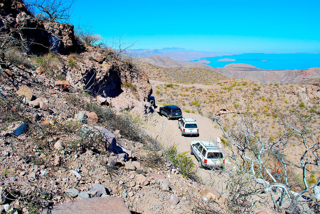
view from the top
download of the track here:
http://www.baja101.com/Baja-GPS/agua-verde-road.kml
[Edited on 3-28-2012 by 4x4abc]
[Edited on 3-28-2012 by 4x4abc]
[Edited on 3-28-2012 by 4x4abc]
Harald Pietschmann
|
|
|
dtbushpilot
Ultra Nomad
Posts: 3297
Registered: 1-11-2007
Location: Buena Vista BCS
Member Is Offline
Mood: Tranquilo
|
|
Cool trip report, can I follow you on your next trip?.......dt
"Life is tough".....It's even tougher if you're stupid.....
|
|
|
sd
Nomad
Posts: 487
Registered: 3-19-2008
Member Is Offline
|
|
Roy passed away in 2006. He was generous sharing his travel logs. His Jeep was a combination of parts from several different vehicles. heavy duty roof
rack could carry anything he put up there.
Roy also made some fun quad trips, also logged with nice photos. A must read for all of us who like traveling Baja.
|
|
|
Neal Johns
Super Nomad
Posts: 1687
Registered: 10-31-2002
Location: Lytle Creek, CA
Member Is Offline
Mood: In love!
|
|
4x4abc is a good dog and knows his 4wd stuff. Used to work with Harry Lewellyn leading innocents into the back country of Baja and the Southwest. No,
not me, I'm too old to be innocent.
My motto:
Never let a Dragon pass by without pulling its tail!
|
|
|
4x4abc
Ultra Nomad
Posts: 4455
Registered: 4-24-2009
Location: La Paz, BCS
Member Is Offline
Mood: happy - always
|
|
| Quote: | Originally posted by dtbushpilot
Cool trip report, can I follow you on your next trip?.......dt |
sure - where do you want to go?
as a variation of "what are you wearing?": what are you driving?
Harald Pietschmann
|
|
|
David K
Honored Nomad
Posts: 65564
Registered: 8-30-2002
Location: San Diego County
Member Is Offline
Mood: Have Baja Fever
|
|
Harry Lewellyn came to my VivaBaja #3 in Oceanside, and I met him earlier at San Cosme on the road to Agua Verde, in Dec. 2001... Introduced himself
as 'The Silver Fox'!
[Edited on 4-1-2012 by David K]
|
|
|
4x4abc
Ultra Nomad
Posts: 4455
Registered: 4-24-2009
Location: La Paz, BCS
Member Is Offline
Mood: happy - always
|
|
yeah, too bad we lost Harry to the big money game
Harald Pietschmann
|
|
|
David K
Honored Nomad
Posts: 65564
Registered: 8-30-2002
Location: San Diego County
Member Is Offline
Mood: Have Baja Fever
|
|
| Quote: | Originally posted by 4x4abc
yeah, too bad we lost Harry to the big money game |
I was getting his newsletter for a while then it stopped... and his web site changed... I just figured he sold his business and retired...?
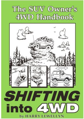
Here is his book, I have a autographed copy...
|
|
|
4x4abc
Ultra Nomad
Posts: 4455
Registered: 4-24-2009
Location: La Paz, BCS
Member Is Offline
Mood: happy - always
|
|
Harry quit his 4x4 guide and training business and started working for Staun Australia - but Staun folded. Now he is running his own business picking
up where Staun stopped.
In his own words:
"For more than 2 decades, Ecological 4-Wheeling Adventures (ECO4WD) offered four wheel drive backcountry adventure tours and 4WD classes, but the
Coyote has moved on. However, we feel much of the material on this site has timeless value, so we leave it up for all to enjoy.
With Staun Australia out of business (great products, but financial problems), Staun USA Inc was dissolved on December 31, 2010. Our new company,
Coyote Enterprises LLC is picking up with the tire deflators and internal pneumatic beadlocks made here in the USA."
http://www.stauntyredeflators.com.au/a_precise_deflation_tes...
http://www.eco4wd.com/
http://www.facebook.com/pages/Coyote-Enterprises-LLC-Staun/2...
[Edited on 4-2-2012 by 4x4abc]
Harald Pietschmann
|
|
|
honda tom
Nomad
Posts: 493
Registered: 8-28-2003
Location: middle calif
Member Is Offline
|
|
met manuel at timbabich 3 days ago. saw the same photo and typed text about the history. he walked us back to the beach were my boat was anchored.
said his wife was in constitution for stomach problems. very friendly guy. kicked him 100 pesos 2 beers and a bag of toys for little girls..... (i
have twin girls and a surplus of like new toys) cool place, like goin a hundred years back in time... except for the generator running the pump at the
well. LOVE IT!
|
|
|
tiotomasbcs
Super Nomad
Posts: 1837
Registered: 7-30-2007
Location: El Pescadero
Member Is Offline
|
|
Sr. Divertido--Roy Baldwin. Mr. Happy. Timbabichi. Never been there but thanks for the article and pictures. Gracias. Another must see. Tio
|
|
|
|


