| Pages:
1
2
3
4 |
David K
Honored Nomad

Posts: 64490
Registered: 8-30-2002
Location: San Diego County
Member Is Offline
Mood: Have Baja Fever
|
|
| Quote: | Originally posted by Blair
Thanks for everything folks, very impressive and invaluable info - read every word more than once. My take-away is yes it is doable, very worthwhile
and probably best done S to N. We will be on a group of 5 bikes on the peninsula from April 14 to the 23 going from San Ignacio to the cape and back.
I think this segment needs to be included.
Mulegena - you mentioned pics of your trip - id love to see them if you have time to post
TW - that comparison 06 to present very interesting - thanks
Kurt G - If you do do this segment (late march?) I would be very interested in LL's of your trip pics and commentary
David - Your website is very informative - Still going through it. Love your mission stuff and the old baja pics - esp the pics of the ruins in the
50's. |
Glad you are enjoying it! The whole point is to help anyone have a Baja adventure! Seeing how the missions have been disappearing over the years is
sad, but thank God people take photos of them! It is hard for me to see how much of missions I have seen when I was a teen, have changed... San
Fernando de Velicata, for example. I camped there on my first (without parents) Baja trip (1974) and took photos. I only wish I went to more missions
in the 1970's. I became more interested in them later on.
|
|
|
David K
Honored Nomad
Posts: 64490
Registered: 8-30-2002
Location: San Diego County
Member Is Offline
Mood: Have Baja Fever
|
|
| Quote: | Originally posted by KurtG
| Quote: | Originally posted by TW
I would be very interested in a trip report on this Guajademi Canyon road as I may do it coming back from the NORRA race in May. It would add an extra
treat to the Agua Verde and Timbabichi trip. |
We plan to go through there around 3/20-21 and will post a report. Hope you will do the same for both the routes you have planned. I've been to Agua
Verde and would like to do the back way out to the south. We have to be a little careful with the Explorer, while it is the Bauer Ed. with 16" wheels
the underside is not well protected and limits some of the places we can go. And David, don't tell us to get a Toyota, the Explorer has a feature we
can't duplicate in any new vehicle. It is paid for! |
Get a Toyota, anyway!!   
|
|
|
David K
Honored Nomad
Posts: 64490
Registered: 8-30-2002
Location: San Diego County
Member Is Offline
Mood: Have Baja Fever
|
|
| Quote: | Originally posted by Blair
Oh and while were in the area....
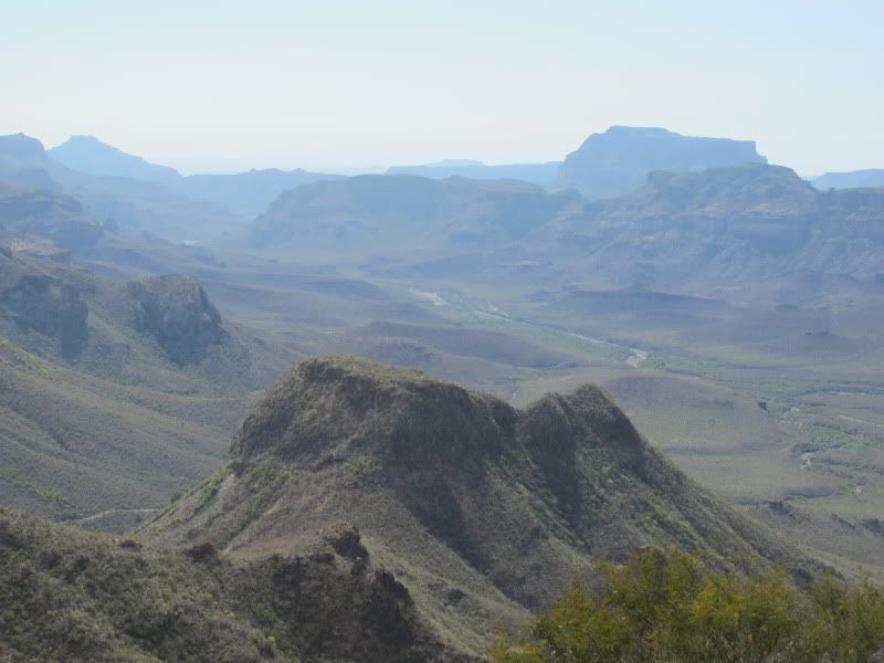
Do any of you know what the name of this canyon is (red arrow)? We found it by accident 3 years ago and have been through there twice. Absolutely
beautiful area!
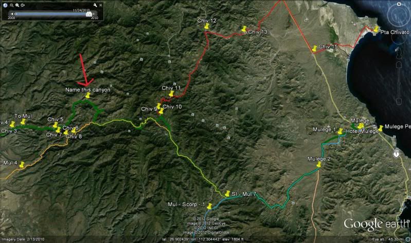
LOOKING NORTHWEST
[Edited on 3-6-2012 by Blair] |
Hi Blair, according to the 2009 Baja Almanac that canyon is called 'Cañada los Picachos' and the arroyo in it is 'Arroyo San Tadeo'... Map 15, C-4 and
D-4. Rancho San Tadeo is on the left edge of the map in the canyon.
The Guadalupe mission looks to be about your waypoint Chiv 9 or Chiv 10.
[Edited on 3-6-2012 by David K]
|
|
|
elfbrewery
Nomad
Posts: 340
Registered: 12-25-2006
Member Is Offline
|
|
I concur that the canyon is up the San Simon wash off the road to San Juan de las Pilas. We took a wrong turn, went up that way to a rancho and came
back down to the correct road.
Has anyone taken the road to San Juan de las Pilas in the last year??
|
|
|
David K
Honored Nomad
Posts: 64490
Registered: 8-30-2002
Location: San Diego County
Member Is Offline
Mood: Have Baja Fever
|
|
The San Juan de las Pilas road is shown on his satellite map (Mul 4, Chiv 8)... but the arrow is pointing to the thet canyon/ valley to the north.
|
|
|
TMW
Select Nomad
Posts: 10659
Registered: 9-1-2003
Location: Bakersfield, CA
Member Is Offline
|
|
We did the San Juan de las Pilas route a few yeas ago going west to east and met the Lady at the ranch. Great adventure. There was one hill climb I
thought I was going to need 4x4 low range.
|
|
|
elfbrewery
Nomad
Posts: 340
Registered: 12-25-2006
Member Is Offline
|
|
We went east to west in March, 2008. It was a tough drive. One hill, although not that long, was just cemented boulders and other stuff with some of
the big rocks missing. So, not only were we mountain-goating up the steep slope, we were doing it with only 3 wheels on the surface at times. It was
also thrilling to negotiate the tight curves even in a jeep. There was one point that looked enticing to drive over, but we stopped to see the view
below, thank Goodness, then found the track almost behind us.
After we came down the west side of the mountains is where we made the mistaken turn out to the rancho mentioned in previous note. No one was there,
but it looked in use (or at least seasonal). We carried on around to the left and back to the SJP road.
When we passed the rancho at SJP the gate was shut. We decided to go a little further and camp the night. Before going to bed, I told our friends that
the route tomorrow would be worse than today and that almost made them pass out on the spot. The map showed road and improved track where we had been,
but only potential track ahead till we hit the ranchos.
The next morning, it was almost true. We hadn't driven too far when the track almost disappeared into a wall of reeds and other shrubs. We pushed our
jeeps through only to find lots of water in front of us. Holy Cow!
Fortunately, the other driver had his flip-flops handy and trudged out into the pooled water to find it only 5" deep, and then spotted where the track
carried on once across. Whew! Didn't want to go back the way we came, especially in failure.
We splashed across pools a couple of times and then made a somewhat steep climb out of the arroyo. The state of the road improved more and more. It's
been graded! We almost flew all the way to El Patrocino. The worst part was the washboard along the San Ignacio road and then the PEMEX being out of
gasoline. But we had a nice lunch in San Ignacio and sat amazed at how fast we got through that "bad" stretch of road. We were home well ahead of time
and our driver kissed the jeep.
So, I wonder how the road has changed since Jimena. Do they sell anything at the SJP ranch (like goat cheese)? If I ever get itchy to do that road
again, I'll post a new thread.
|
|
|
elfbrewery
Nomad
Posts: 340
Registered: 12-25-2006
Member Is Offline
|
|
Could someone please give me the coordinates for Pie de la Cuesta?
Cheers!
|
|
|
David K
Honored Nomad
Posts: 64490
Registered: 8-30-2002
Location: San Diego County
Member Is Offline
Mood: Have Baja Fever
|
|
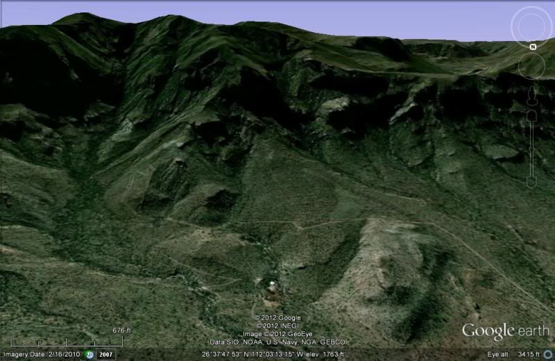
The 'foot of the grade' (to/from Guajademi), as in the rancho at the end of the road from Mulege and where the Camino Real goes up/ comes down?
At Rancho Pie de la Cuesta de Guajademi: 26º38'04.80", -112º03'11.27" elev. 1,365'
Looking South, ranch at bottom center:
[Edited on 3-7-2012 by David K]
|
|
|
elfbrewery
Nomad
Posts: 340
Registered: 12-25-2006
Member Is Offline
|
|
Yup, that's where we were a few years ago. Do you pay for Google Earth? I don't and I don't have good imagery for the switchbacks you talk about due
to the shade in the mountain range. At least I know I can get back to that place as a starting point for the climb over the pass. I guess if the road
has been bladed since Jimena, there's a chance to find it. Looks gnarly at any rate, which makes it fun.
Thanks for your help!
|
|
|
TMW
Select Nomad
Posts: 10659
Registered: 9-1-2003
Location: Bakersfield, CA
Member Is Offline
|
|
Google Earth is free. The download is big so depending on your internet connection speed it can take a while but well worth it.
|
|
|
David K
Honored Nomad
Posts: 64490
Registered: 8-30-2002
Location: San Diego County
Member Is Offline
Mood: Have Baja Fever
|
|
The auto road with switchbacks is not at Pie de la Cuesta, but over on the west side of that valley.
The Camino Real mission trail does come down the mountain to Pie de la Cuesta from Guajademi, and you can see it, but not too well because of the
shadow... and it wasn't built as well as the main Camino Real between La Purisima and San Ignacio via Guadalupe mission.
|
|
|
elfbrewery
Nomad
Posts: 340
Registered: 12-25-2006
Member Is Offline
|
|
Okay. I've spent an hour or so studying the Almanac and GE trying to make sense of it all. So, north of Pie de la Cuesta, you say the driveable road
that goes southwest to Las Chivas snakes counter-clockwise around the mountains and comes back into the Guajademi Canyon north of Agua Grande. That is
why you say the El Camino Real goes through Pie de la Cuesta, but that would not be driveable, correct?
|
|
|
Mulegena
Super Nomad
Posts: 2412
Registered: 11-7-2006
Member Is Offline
|
|
slideshow of our trip March 3, 2012...
Canyon Guajademi from La Purisima to Mulege on the Paso Hondo trail: http://s1124.photobucket.com/albums/l565/lmaria43/Arroyo%20G...
"Raise your words, not your voice. It's rain that grows flowers, not thunder." ~Rumi
"It's the mark of an educated mind to be able to entertain a thought without accepting it." ~ Aristotle
|
|
|
bajalou
Ultra Nomad
Posts: 4459
Registered: 3-11-2004
Location: South of the broder
Member Is Offline
|
|
This is what I get when I click the link----
"This is a Private Album
Please enter the password from album lmaria43 to view this private album."
No Bad Days
\"Never argue with an idiot. People watching may not be able to tell the difference\"
\"The trouble with doing nothing is - how do I know when I\'m done?\"
Nomad Baja Interactive map
And in the San Felipe area - check out Valle Chico area |
|
|
Mulegena
Super Nomad
Posts: 2412
Registered: 11-7-2006
Member Is Offline
|
|
oops, thanks Bajalou...
firstimer I am...
access is now public (i think)
if it still requires a code, try "Guajademi"
Mulegena
"Raise your words, not your voice. It's rain that grows flowers, not thunder." ~Rumi
"It's the mark of an educated mind to be able to entertain a thought without accepting it." ~ Aristotle
|
|
|
David K
Honored Nomad
Posts: 64490
Registered: 8-30-2002
Location: San Diego County
Member Is Offline
Mood: Have Baja Fever
|
|
What a 'great' road!!! Thanks for the slide show... what a trip!
|
|
|
David K
Honored Nomad
Posts: 64490
Registered: 8-30-2002
Location: San Diego County
Member Is Offline
Mood: Have Baja Fever
|
|
| Quote: | Originally posted by elfbrewery
Okay. I've spent an hour or so studying the Almanac and GE trying to make sense of it all. So, north of Pie de la Cuesta, you say the driveable road
that goes southwest to Las Chivas snakes counter-clockwise around the mountains and comes back into the Guajademi Canyon north of Agua Grande. That is
why you say the El Camino Real goes through Pie de la Cuesta, but that would not be driveable, correct? |
That is how the new auto road looks to me on Google Earth, yes.
The Camino Real comes down the mountain (northbound) to Pie de la Cuesta, correct. I do not know if it was ever drivable in a 4WD. It doesn't look
like it, from space.
|
|
|
elfbrewery
Nomad
Posts: 340
Registered: 12-25-2006
Member Is Offline
|
|
Mulagena,
Great to see the countryside and the road conditions. Was the photo of the truck almost sliding down the loose rocks the worst part of the drive??
David,
Thanks. My curiosity is sated for that route. Does the other El Camino Road still exist? Is it driveable??
Cheers, y'all!
|
|
|
David K
Honored Nomad
Posts: 64490
Registered: 8-30-2002
Location: San Diego County
Member Is Offline
Mood: Have Baja Fever
|
|
| Quote: | Originally posted by elfbrewery
Mulagena,
Great to see the countryside and the road conditions. Was the photo of the truck almost sliding down the loose rocks the worst part of the drive??
David,
Thanks. My curiosity is sated for that route. Does the other El Camino Road still exist? Is it driveable??
Cheers, y'all! |
You can see a lot of the Camino Real still, between San Javier and Santa Maria... I have saved dozens or maybe hundreds of images of the Camino Real
on Google Earth as well as maps pointing to where each image is showing. The page with all the links to Baja Nomad posts with the images and maps is
here: http://vivabaja.com/missions2/page13.html
This page is at the end of the 27 Baja mission info and photos (end of mission/2): http://vivabaja.com/bajamissions
Most of it is suitable to foot, mule, burro or maybe trail bike... Only where auto roads have been placed on the top of the Camino Real is it drivable
(like Santa Marta north towards La Trinidad, or other places. The road south of the Magdalena ruins (near Mulege) is likely the Camino Real route.
[Edited on 3-8-2012 by David K]
|
|
|
| Pages:
1
2
3
4 |


