| Pages:
1
2
3
..
5 |
4x4abc
Ultra Nomad

Posts: 4199
Registered: 4-24-2009
Location: La Paz, BCS
Member Is Online
Mood: happy - always
|
|
mysterious air strip
now here is a question for you Baja buffs: saw it on an older map some years ago and when Google Earth became available I checked it out.
Yes, there is an air strip high up in the Sierra la Asamblea. Who put it there? When and why?
http://www.baja101.com/Baja-GPS/airstrip.kmz

Harald Pietschmann
|
|
|
Fernweh
Nomad
Posts: 444
Registered: 2-24-2011
Location: Centenario, BCS
Member Is Offline
|
|
Harald,
as per Google Earth the strip measures about 865' of length.
That is quiet short for a runway at a +4000' elevation. The elevation difference between both strip ends is about 36'.
The terrain start to rise up approx. 1 mile away from the end of "runway 21" (downhill runway)
Too short for me to fly in there
Karl
|
|
|
mtgoat666
Select Nomad
Posts: 17389
Registered: 9-16-2006
Location: San Diego
Member Is Offline
Mood: Hot n spicy
|
|
| Quote: | Originally posted by 4x4abc
Yes, there is an air strip high up in the Sierra la Asamblea. Who put it there? When and why?
|
same aliens that gave us all implants!
|
|
|
Barry A.
Select Nomad
Posts: 10007
Registered: 11-30-2003
Location: Redding, Northern CA
Member Is Offline
Mood: optimistic
|
|
| Quote: | Originally posted by mtgoat666
| Quote: | Originally posted by 4x4abc
Yes, there is an air strip high up in the Sierra la Asamblea. Who put it there? When and why?
|
same aliens that gave us all implants! |
I suspect the Goat is speaking from experience.
Barry
|
|
|
woody with a view
PITA Nomad
Posts: 15938
Registered: 11-8-2004
Location: Looking at the Coronado Islands
Member Is Offline
Mood: Everchangin'
|
|
rockerfellers or kennedys. either way, it's old money, er cartel!
|
|
|
4x4abc
Ultra Nomad
Posts: 4199
Registered: 4-24-2009
Location: La Paz, BCS
Member Is Online
Mood: happy - always
|
|
| Quote: | Originally posted by Fernweh
Harald,
as per Google Earth the strip measures about 865' of length.
That is quiet short for a runway at a +4000' elevation. The elevation difference between both strip ends is about 36'.
The terrain start to rise up approx. 1 mile away from the end of "runway 21" (downhill runway)
Too short for me to fly in there
Karl |
Karl,
too short to fly in or not - someone went through the pain of creating this thing (bulldozer etc?) who and why?
Harald Pietschmann
|
|
|
David K
Honored Nomad
Posts: 64526
Registered: 8-30-2002
Location: San Diego County
Member Is Offline
Mood: Have Baja Fever
|
|
What's interesting is that there is no road leading up to it... It looks like a mission trail, but on top of a mountain with no connection up or down?
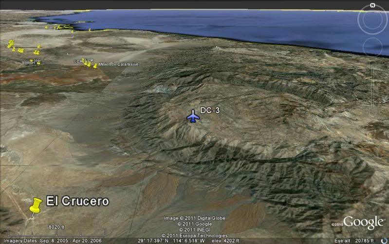
Have you seen the DC-3 wreck on Cerro La Gobernadora... just northeast of El Crucero, near the top?
|
|
|
dtbushpilot
Ultra Nomad
Posts: 3288
Registered: 1-11-2007
Location: Buena Vista BCS
Member Is Offline
Mood: Tranquilo
|
|
It would be "sporty" but doable in a bush plane, C180, C185, maybe even a 206. It would be a piece of cake in a super cub or similar
plane.....assuming it was somewhat maintained.
"Life is tough".....It's even tougher if you're stupid.....
|
|
|
Bob H
Elite Nomad
Posts: 5867
Registered: 8-19-2003
Location: San Diego
Member Is Offline
|
|
| Quote: | Originally posted by David K
What's interesting is that there is no road leading up to it... It looks like a mission trail, but on top of a mountain with no connection up or down?
Have you seen the DC-3 wreck on Cerro La Gobernadora... just northeast of El Crucero, near the top? |
This air strip looks like a drop off place for a helicopter transfer of drugs! Very efficient and clandestine for this type of activity. A small
plane lands, unloads to a helicopter, etc.
[Edited on 3-17-2012 by Bob H]
The SAME boiling water that softens the potato hardens the egg. It's about what you are made of NOT the circumstance.
|
|
|
larryC
Super Nomad
Posts: 1482
Registered: 8-11-2008
Location: BoLA
Member Is Offline
|
|
When I was researching a planned trip to Salsipuedes canyon years ago I talked to Fransisco Munoz about that airstrip. He said it was an illegal strip
used to drop off big horn sheep hunters, probably back in the 50's and 60's.
Larry
|
|
|
4x4abc
Ultra Nomad
Posts: 4199
Registered: 4-24-2009
Location: La Paz, BCS
Member Is Online
Mood: happy - always
|
|
| Quote: | Originally posted by David K
What's interesting is that there is no road leading up to it... It looks like a mission trail, but on top of a mountain with no connection up or down?
Have you seen the DC-3 wreck on Cerro La Gobernadora... just northeast of El Crucero, near the top? |
Haven't seen the DC-3 - never heard about it. Do you have a fixed point?
Harald Pietschmann
|
|
|
capt. mike
Elite Nomad
Posts: 8085
Registered: 11-26-2002
Location: Bat Cave
Member Is Offline
Mood: Sling time!
|
|
i like Larry's idea. Munoz would have known.
a Storch with big tires could have done it easily and with a load of hunters.
formerly Ordained in Rev. Ewing\'s Church by Mail - busted on tax fraud.......
Now joined L. Ron Hoover\'s church of Appliantology
\"Remember there is a big difference between kneeling down and bending over....\"
www.facebook.com/michael.l.goering |
|
|
David K
Honored Nomad
Posts: 64526
Registered: 8-30-2002
Location: San Diego County
Member Is Offline
Mood: Have Baja Fever
|
|
| Quote: | Originally posted by 4x4abc
| Quote: | Originally posted by David K
What's interesting is that there is no road leading up to it... It looks like a mission trail, but on top of a mountain with no connection up or down?
Have you seen the DC-3 wreck on Cerro La Gobernadora... just northeast of El Crucero, near the top? |
Haven't seen the DC-3 - never heard about it. Do you have a fixed point? |
In 2004, I posted a reply to TW about Erle Stanley Gardner's book chapter on the lost mission of Santa Ysabel... Erle describes its location in
relation to the DC-3 wreck... So, thanks to Nomad Search, here is the location (provided by BillB, who hiked up to it):
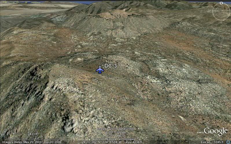
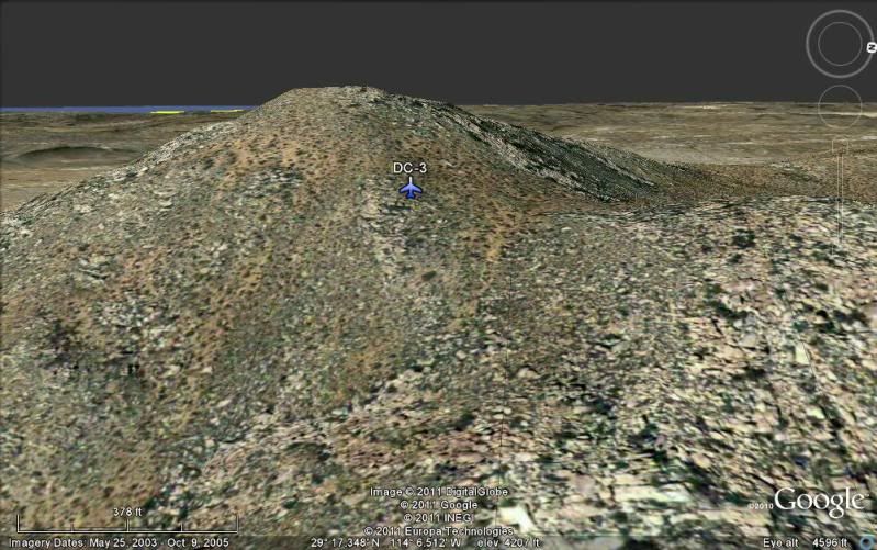
The DC-3 plane wreck that the chapter starts out talking about is on Cerro la Gobernadora (just northeast of El Crucero). GPS at the wreck is:
29°17.33'/ 114°06.57'
[Edited on 10-15-2019 by David K]
|
|
|
David K
Honored Nomad
Posts: 64526
Registered: 8-30-2002
Location: San Diego County
Member Is Offline
Mood: Have Baja Fever
|
|
| Quote: | Originally posted by larryC
When I was researching a planned trip to Salsipuedes canyon years ago I talked to Fransisco Munoz about that airstrip. He said it was an illegal strip
used to drop off big horn sheep hunters, probably back in the 50's and 60's.
Larry |
Very cool detail! Thanks Larry!
|
|
|
willardguy
Elite Nomad
Posts: 6451
Registered: 9-19-2009
Member Is Offline
|
|
are there any photo's of the dc-3?
|
|
|
David K
Honored Nomad
Posts: 64526
Registered: 8-30-2002
Location: San Diego County
Member Is Offline
Mood: Have Baja Fever
|
|
| Quote: | Originally posted by willardguy
are there any photo's of the dc-3? |
BillB sent them to me, so I need to search and try and find them.
They were posted on Nomad, but this site lost many years of photos posted that were hosted on Nomad (one reason why I use Photobucket now)... Doug
says he can get them back, but he has been saying that for years... and it is old stuff, so how many look back at old posts?
|
|
|
mtgoat666
Select Nomad
Posts: 17389
Registered: 9-16-2006
Location: San Diego
Member Is Offline
Mood: Hot n spicy
|
|
| Quote: | Originally posted by David K
| Quote: | Originally posted by 4x4abc
| Quote: | Originally posted by David K
What's interesting is that there is no road leading up to it... It looks like a mission trail, but on top of a mountain with no connection up or down?
Have you seen the DC-3 wreck on Cerro La Gobernadora... just northeast of El Crucero, near the top? |
Haven't seen the DC-3 - never heard about it. Do you have a fixed point? |
In 2004, I posted a reply to TW about Erle Stanley Gardner's book chapter on the lost mission of Santa Ysabel... Erle describes its location in
relation to the DC-3 wreck... So, thanks to Nomad Search, here is the location (provided by BillB, who hiked up to it):
The DC-3 plane wreck that the chapter starts out talking about is on Cerro la Gobernadora (just northeast of El Crucero). GPS at the wreck is:
29º17.33'/ 114º06.57' |
corrected nomenclature for those coords is 29º 17.33' -114º 06.57' (dk: you forgot that you need to say negative long when citing coords in mexico)
but nothing visible in google earth at that location
|
|
|
David K
Honored Nomad
Posts: 64526
Registered: 8-30-2002
Location: San Diego County
Member Is Offline
Mood: Have Baja Fever
|
|
Goat, most of us know that we are in the Western Hemisphere and a W or - sign must go along with the numbers on Google Earth.
I have not been able to yet find the DC-3 wreck photos from BillB... I do remember that there wasn't much left... The wreck is near the top on the
eastern slope face, from my memory.
The GPS waypoing might be NAD27 and needs to be converted to WGS84 for Google Earth. When/ if I find the photos or the wreck on GE, I will post it
here...
|
|
|
Udo
Elite Nomad
Posts: 6326
Registered: 4-26-2008
Location: Black Hills, SD/Ensenada/San Felipe
Member Is Offline
Mood: TEQUILA!
|
|
The DC-3 is at the army base in Ensenada. It currently has a yellow tail.
Udo
Youth is wasted on the young!
|
|
|
David K
Honored Nomad
Posts: 64526
Registered: 8-30-2002
Location: San Diego County
Member Is Offline
Mood: Have Baja Fever
|
|
[Edited on 3-17-2012 by David K]
|
|
|
| Pages:
1
2
3
..
5 |


