| Pages:
1
2
3 |
Taco de Baja
Super Nomad

Posts: 1913
Registered: 4-14-2004
Location: Behind the Orange Curtain, CA
Member Is Offline
Mood: Dreamin' of Baja
|
|
Sierra Juarez to Sierra Tinajas and Beyond Trip Report II
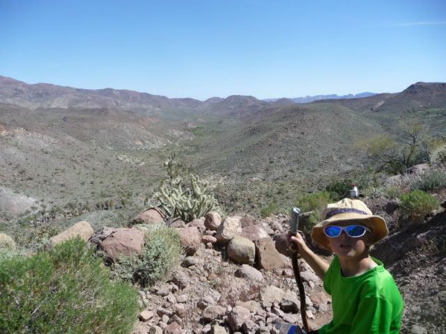
Here are some more photos to add to Mexitron's trip report.
Weather was very nice, except for the first morning when we had freezing rain. Highs were usually no more than 90 in the day and low in the 40s at
night.
I will work on getting a Google Earth KMZ track tomorrow. I first need to isolate and combine the paths from a trip up the mountain from Rancho El
Mano with this trip (down the mountain) as well as remove all the other way-points and tracks that are in my GPS.
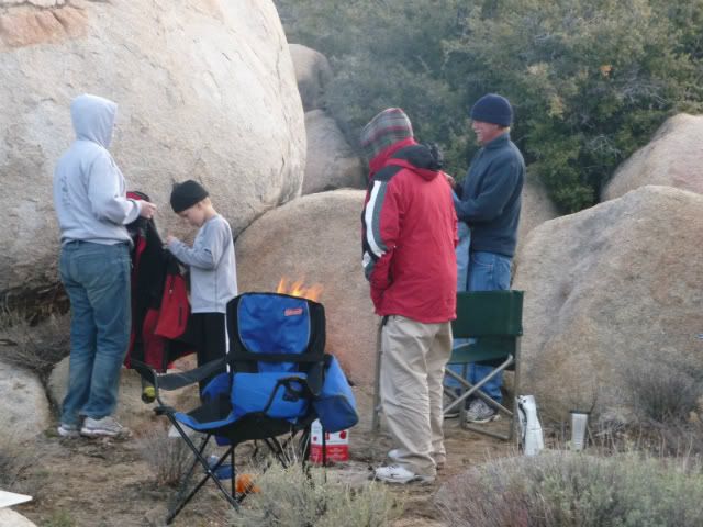
Warming up and drying out in the 30 degree first morning.
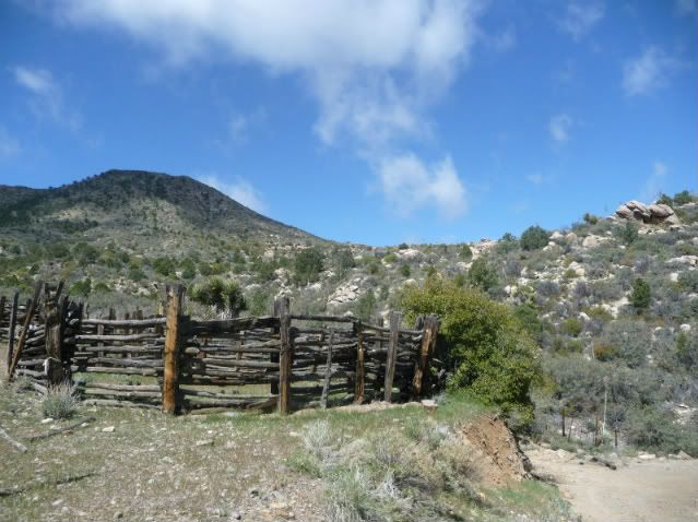
Abandoned Ranch part way down mountain
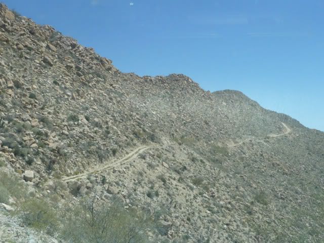
Steep road in burn area
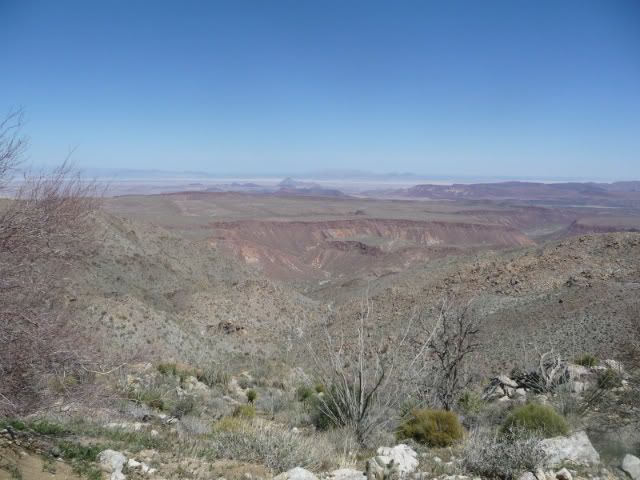
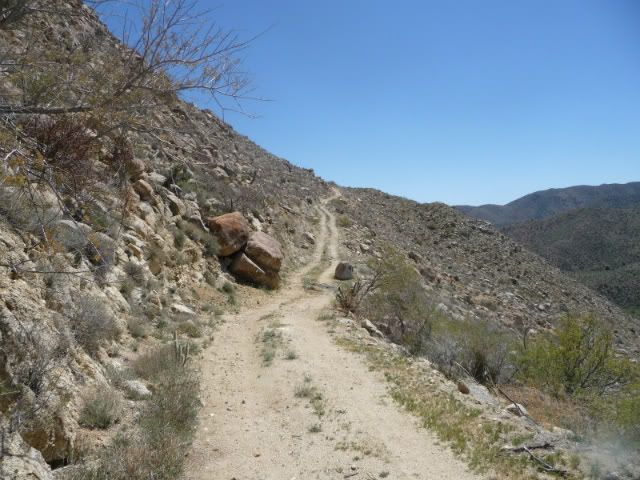
Mesa La Vibora
Canyon El Mano
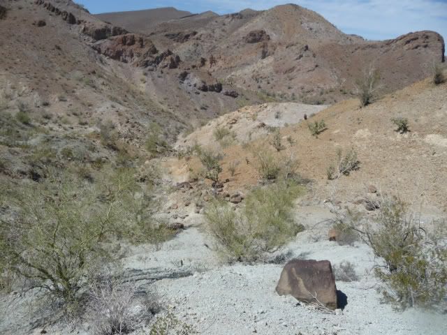
Hiking up canyon from Agua Caliente Spring
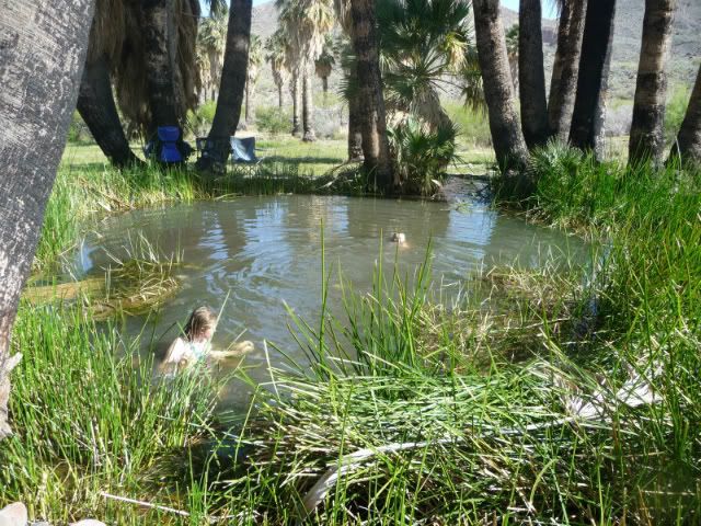
Agua Caliente Pool
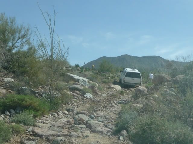
One of the bad sections after leaving Agua Caliente. We did not know we were in for worse. 
Yes, there's a road there someplace....
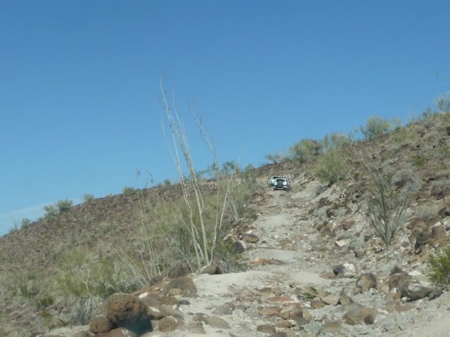
One of the white knuckle areas. Large rocks, off camber slippery.
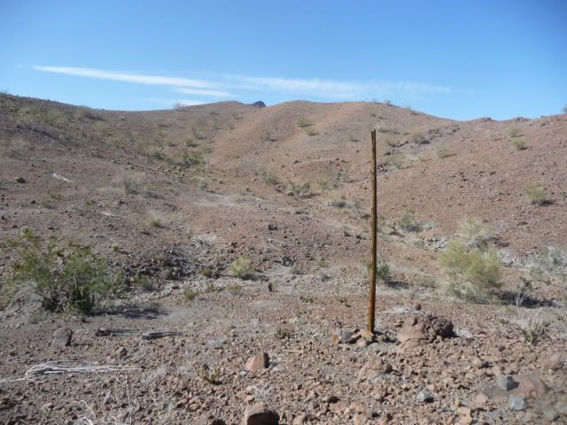
One of the few remaining poles along the pole line road.
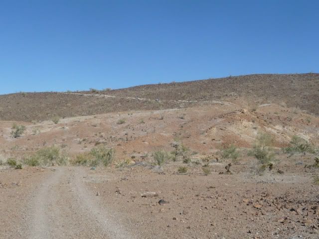
I believe this is "Basketball Hill"
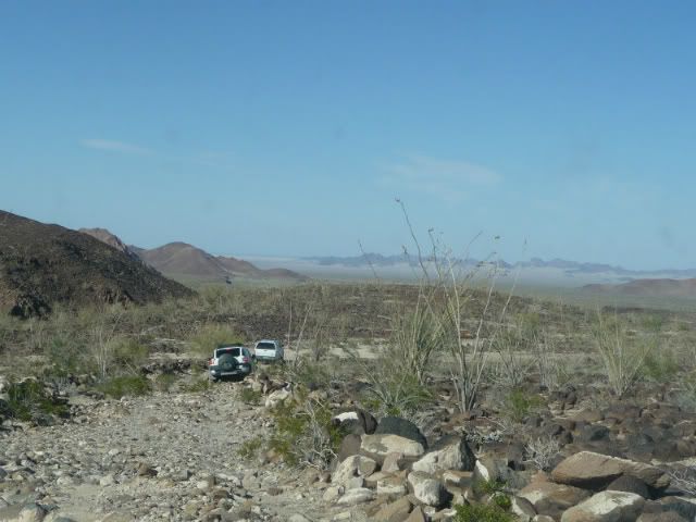
Area on top of "Basketball Hill"
Truth generally lies in the coordination of antagonistic opinions
-Herbert Spencer
|
|
|
Taco de Baja
Super Nomad
Posts: 1913
Registered: 4-14-2004
Location: Behind the Orange Curtain, CA
Member Is Offline
Mood: Dreamin' of Baja
|
|
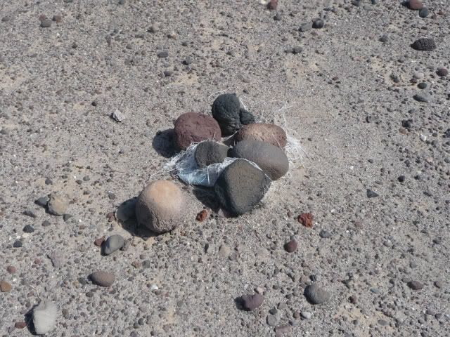
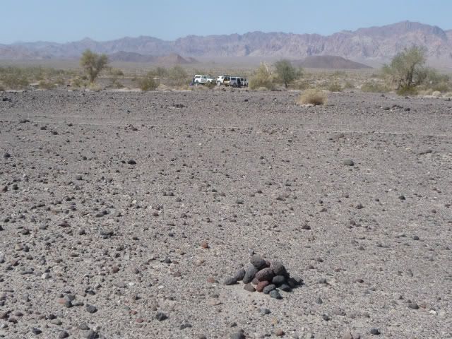
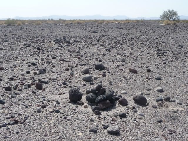
Also found these strange rock piles south of Tres Pozos, east of the Sierra Tinajas on our last day. I have seen similar piles in the desert east of
Barstow, CA along the Old National Trails Highway but without the sandbags under them, or at least not visible. Any ideas what they might be? they
appear to be randomly placed and generally not close enough to be something like tent tie-downs.
Truth generally lies in the coordination of antagonistic opinions
-Herbert Spencer
|
|
|
Taco de Baja
Super Nomad
Posts: 1913
Registered: 4-14-2004
Location: Behind the Orange Curtain, CA
Member Is Offline
Mood: Dreamin' of Baja
|
|
Alas, all was not without breakage.
This happened early on in the trip. I heard a large BANG! and thought I had broken a leaf spring, or something...a quick look around the truck at
springs and drive shafts showed nothing amiss, and the truck operated fine. It was not until I got home and did a more thorough inspection that I
found this:
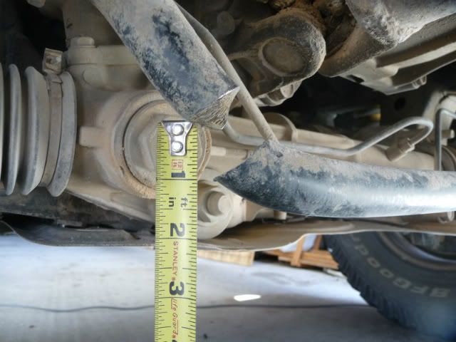
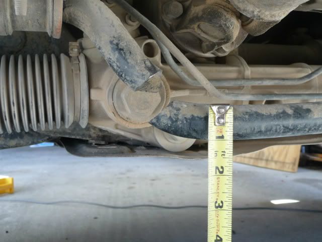
Who knows, maybe it helped; kind of like an anti-swaybar quick disconnect 
Truth generally lies in the coordination of antagonistic opinions
-Herbert Spencer
|
|
|
David K
Honored Nomad
Posts: 65562
Registered: 8-30-2002
Location: San Diego County
Member Is Online
Mood: Have Baja Fever
|
|
Excellent post Brooks! Great that you saw some poles (at least one)... from 1941!
|
|
|
TMW
Select Nomad
Posts: 10659
Registered: 9-1-2003
Location: Bakersfield, CA
Member Is Offline
|
|
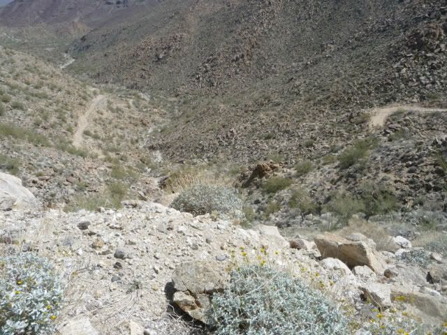
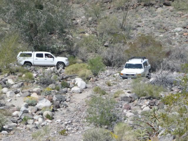
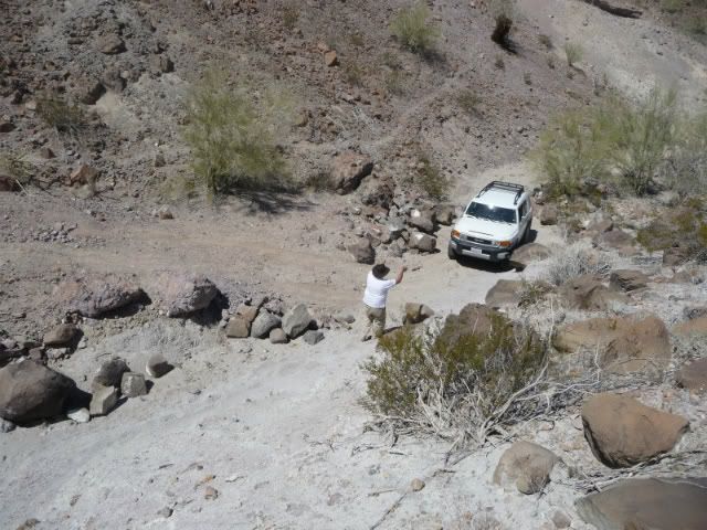
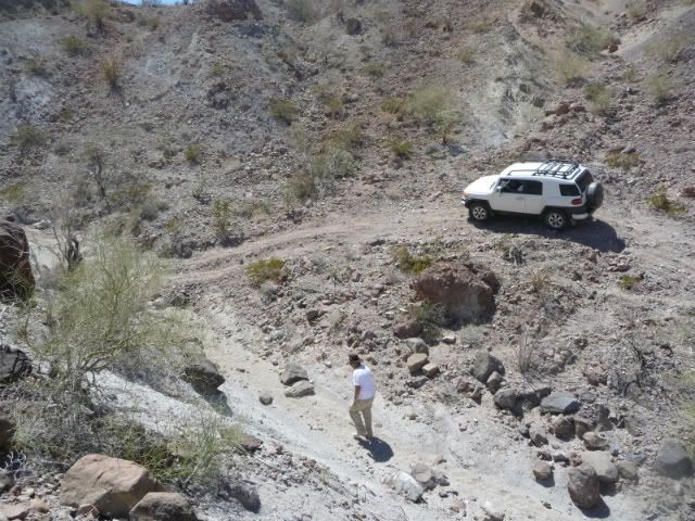
That was not basketball hill in the picture above. Basketball hill is right after turning out of the wash. Turn right out of the wash then left turn
up BB hill and over and down to another wash. Total distance is maybe 1.5 miles wash to wash. The rock piles are called cairns and used to mark a
trail usually found at a junction and just past the crossroad on the right.
|
|
|
TMW
Select Nomad
Posts: 10659
Registered: 9-1-2003
Location: Bakersfield, CA
Member Is Offline
|
|
Holy cow on breaking the sway bar, never seen that done. Jeeps and some others usually disconnect it when going off road.
|
|
|
TMW
Select Nomad
Posts: 10659
Registered: 9-1-2003
Location: Bakersfield, CA
Member Is Offline
|
|
Where the man is in the wash and appears to be walking with the SUV to his right that looks like the bottom of BB Hill. There was a large rock that
fell down into the old road trail and we had to make a new road up and around it and that looks like it.
|
|
|
Mexitron
Ultra Nomad
Posts: 3397
Registered: 9-21-2003
Location: Fort Worth, Texas
Member Is Offline
Mood: Happy!
|
|
Nice pics and report Brooks. Geez, so that was the sound you heard....wow! Huddo really missed it...
|
|
|
Taco de Baja
Super Nomad
Posts: 1913
Registered: 4-14-2004
Location: Behind the Orange Curtain, CA
Member Is Offline
Mood: Dreamin' of Baja
|
|
| Quote: | Originally posted by Ken Cooke
Basketball Hill - 2005

Baskeball Hill - 2012
This long hill will take your breath away if you're not prepared for it. Worn tires with 3/32nds of tread didn't help, either.
|
I know, I know!
I think this was one of the worst areas. Had to take a break at the top for and wait for the adrenaline shakes to go away
Truth generally lies in the coordination of antagonistic opinions
-Herbert Spencer
|
|
|
Taco de Baja
Super Nomad
Posts: 1913
Registered: 4-14-2004
Location: Behind the Orange Curtain, CA
Member Is Offline
Mood: Dreamin' of Baja
|
|
| Quote: | Originally posted by TW
The rock piles are called cairns and used to mark a trail usually found at a junction and just past the crossroad on the right.
|
The ones we saw in Baja and the ones east of Barstow do not appear to be trail marker cairns. They are scattered randomly over several acres (over
100 acres in for Barstow). The only trails near the ones in Baja were cattle/livestock and the trails did not really follow the piles....
I have seen similar cairns that mark mining claims in the Mojave Desert, but they are isolated, no other piles around. These Baja and Barstow
"cairns" are sometimes several feet to 10s of feet to 100s of feet apart. The ones near Barstow are likely older, so if there were any sandbags under
them they would have been made out of burlap and probably rotted away long ago.
I was just wondering if anybody had seen these in other areas, or knew their purpose. All the archaeologists in my office have their opinions, and
for the ones in Barstow we can not even agree if they were historic, of prehistoric.
The plastic sandbags under the piles in Baja definitely indicates a historic origin, but still not a purpose. Who buries a sandbag under a pile of
rocks? and why? 
Truth generally lies in the coordination of antagonistic opinions
-Herbert Spencer
|
|
|
Taco de Baja
Super Nomad
Posts: 1913
Registered: 4-14-2004
Location: Behind the Orange Curtain, CA
Member Is Offline
Mood: Dreamin' of Baja
|
|
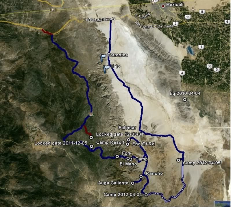
Google Earth Track Log
Here is an image of the track log. This is a combo track log with another 3 day trip we did in Dec 2011 when we camped in a canyon South of Palomar,
Agua Caliente, and an area near Rancho El Mano and going up the Sierra Juarez road all in a clockwise loop. The latest trip was a longer counter
clockwise loop, with a start on top (not shown) closer to Rumorosa going down the Sierra Juarez and through the Sierra Tinajas and up the Laguna
Salada.
Anyone know how to attach the KMZ Google Earth File?
That way anyone can zoom in and out for more detail.
Truth generally lies in the coordination of antagonistic opinions
-Herbert Spencer
|
|
|
TMW
Select Nomad
Posts: 10659
Registered: 9-1-2003
Location: Bakersfield, CA
Member Is Offline
|
|
| Quote: | Originally posted by Taco de Baja
Alas, all was not without breakage.
This happened early on in the trip. I heard a large BANG! and thought I had broken a leaf spring, or something...a quick look around the truck at
springs and drive shafts showed nothing amiss, and the truck operated fine. It was not until I got home and did a more thorough inspection that I
found this:
Who knows, maybe it helped; kind of like an anti-swaybar quick disconnect
|
Was this on the FJ or the Tacoma.
|
|
|
Taco de Baja
Super Nomad
Posts: 1913
Registered: 4-14-2004
Location: Behind the Orange Curtain, CA
Member Is Offline
Mood: Dreamin' of Baja
|
|
| Quote: | Originally posted by TW
| Quote: | Originally posted by Taco de Baja
Alas, all was not without breakage.
This happened early on in the trip. I heard a large BANG! and thought I had broken a leaf spring, or something...a quick look around the truck at
springs and drive shafts showed nothing amiss, and the truck operated fine. It was not until I got home and did a more thorough inspection that I
found this:
Who knows, maybe it helped; kind of like an anti-swaybar quick disconnect
|
Was this on the FJ or the Tacoma. |
This was my 1996 Tacoma that I have had since Jan 1996. First trip to Baja was in April 1996 with paper plates  . Looks like a new anti-sway bar is a little over $100 at the TRDParts4U.com (Toyota of Dallas). Not as bad as I first
thought for a hunk of steel over an inch in diameter (27mm). . Looks like a new anti-sway bar is a little over $100 at the TRDParts4U.com (Toyota of Dallas). Not as bad as I first
thought for a hunk of steel over an inch in diameter (27mm).
The FJ also wore out it's brakes on this trip and requires new rotors and pads. Another reason I prefer a manual transmission.  1st gear and 4-low will creep down most slopes with no braking. 1st gear and 4-low will creep down most slopes with no braking.
No damage to Mexitron's second gen Tacoma that I know of.
Truth generally lies in the coordination of antagonistic opinions
-Herbert Spencer
|
|
|
TMW
Select Nomad
Posts: 10659
Registered: 9-1-2003
Location: Bakersfield, CA
Member Is Offline
|
|
I don't remember how the sway bar was attached on the 2nd gen Tacoma like yours (I had a 2007 work truck) but my 2004 Tacoma I don't like the way it
is attached, it takes an allen wrench to hold the bottom bolt while tightening the nut. I like the older way that my 1993 was done, just a straight
rod about 6 or 8 inchers long with bushings top and bottom. The 2004 is a two piece L shaped gadget with no bushing, more like a balljoint.
|
|
|
Mexitron
Ultra Nomad
Posts: 3397
Registered: 9-21-2003
Location: Fort Worth, Texas
Member Is Offline
Mood: Happy!
|
|
| Quote: | Originally posted by Taco de Baja
[
This was my 1996 Tacoma that I have had since Jan 1996. First trip to Baja was in April 1996 with paper plates . Looks like a new anti-sway bar is a little over $100 at the TRDParts4U.com (Toyota of Dallas). Not as bad as I first
thought for a hunk of steel over an inch in diameter (27mm).
The FJ also wore out it's brakes on this trip and requires new rotors and pads. Another reason I prefer a manual transmission. 1st gear and 4-low will creep down most slopes with no braking.
No damage to Mexitron's second gen Tacoma that I know of. |
Delia was wondering about the new desert pinstriping... 
|
|
|
Mexitron
Ultra Nomad
Posts: 3397
Registered: 9-21-2003
Location: Fort Worth, Texas
Member Is Offline
Mood: Happy!
|
|
| Quote: | Originally posted by Ken Cooke
 |
Cool map Ken!
BTW---when we came to where the Pole Line Road intersects with the Arroyo Grande/La Ventana Road it looked like the eastern direction was all washed
out---couldn't tell if the road headed down the arroyo and hooked up with the Arroyo Grande/la Ventana road or not. We were interested in taking
that route out to Mex Hwy 3 sometime. Have you driven that?
|
|
|
David K
Honored Nomad
Posts: 65562
Registered: 8-30-2002
Location: San Diego County
Member Is Online
Mood: Have Baja Fever
|
|
As I noted the last time you posted that nice map, the far right arroyo crossing labled is Grande, not Jaquegel...
|
|
|
David K
Honored Nomad
Posts: 65562
Registered: 8-30-2002
Location: San Diego County
Member Is Online
Mood: Have Baja Fever
|
|
| Quote: | Originally posted by Mexitron
Cool map Ken!
BTW---when we came to where the Pole Line Road intersects with the Arroyo Grande/La Ventana Road it looked like the eastern direction was all washed
out---couldn't tell if the road headed down the arroyo and hooked up with the Arroyo Grande/la Ventana road or not. We were interested in taking
that route out to Mex Hwy 3 sometime. Have you driven that? |
Just last New Years we drove from La Ventana out to Arroyo Grande (water well for gold mine), then down Arroyo Grande to the Pole Line road, then
back.
Arroyo Grande in that section is a SCORE race course and was the Nov., 2011 Baja 1000... Nicely whooped up and very slow driving. However, from the
well to Hwy. 5 at La Ventana (just south of La Ventana)... is VERY fast!
[Edited on 4-17-2012 by David K]
|
|
|
Barry A.
Select Nomad
Posts: 10007
Registered: 11-30-2003
Location: Redding, Northern CA
Member Is Offline
Mood: optimistic
|
|
------to be picky----- I question the designation "highway 5 N/S".. Surely that is not correct!?!?!?! Highway 5 would be much further east, it seems
to me?!?!?!?!
Barry
|
|
|
Ken Cooke
Elite Nomad
Posts: 8971
Registered: 2-9-2004
Location: Riverside, CA
Member Is Offline
Mood: Pole Line Road postponed due to injury
|
|
| Quote: | Originally posted by David K
As I noted the last time you posted that nice map, the far right arroyo crossing labled is Grande, not Jaquegel... |
Correct. The label is for the *junction* - a road which bisects the Pole Line Road.
|
|
|
| Pages:
1
2
3 |


