| Pages:
1
2 |
Bajatripper
Ultra Nomad

Posts: 3145
Registered: 3-20-2010
Member Is Offline
|
|
On The Road To Timbabichi
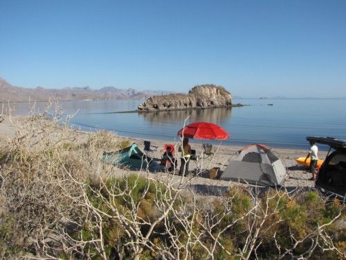
We got a late start out of La Paz, around 4 p.m., so my family and I arrived at the designated rendezvous area near Bahia Agua Verde about an hour
after sunset on Sunday, the 29th. We had decided to get there a day (or at least a night) early so we could get in some extra camp time. Wed been to
Agua Verde a couple of times before, so where somewhat familiar with the layout. Even so, had it not been for Fernwehs posting of that google shot
with the highlighted road to the palapa on the beach, Im sure wed have struggled to find the site in the dark. I annotated it in my Baja Almanac and
tried to commit it to memory. We had no problem locating the camp and I felt a sense of relief when I finally made out the silhouette of the mentioned
palapa in the dark, the confirmation Id been hoping for. While the flat area next to the point was empty, there were other Americans camping down the
beach. We opted for a small sandy rise nearby since we were bagging it in tents. The night was clear with a bit of moon, which dropped below the
sierra to our west sometime after midnight. During my infrequent moments awake, I glanced up to check the Big Dippers progress around the North Star.
The next day was spent beachcombing, swimming, kayaking and hiking while we waited for our fellow Nomads to arrive. My two boys found seven golf balls
while snorkeling in the small cove in front of us. In the early afternoon, my wife and I took the kayak around the point to the next beach over, where
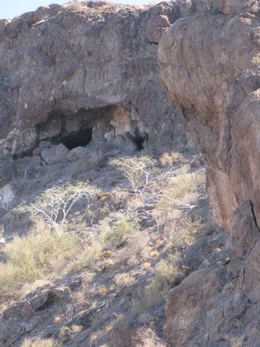
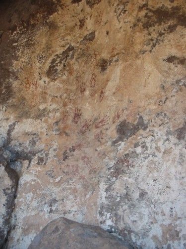
we knew of a cave that has some indigenous markingsmostly handprintson the wall by the entrance. We hiked up to it to take some pictures before
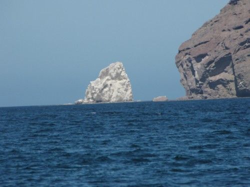
returning to the camp, briefly stopping at the tip of the point to take pictures of Solitary Rockthe bright white rock off the village at Agua Verde.
Karl (Fernweh) driving his awesome Mercedes and Roy (Squarecircle) and Blanche in their impressive and luxurious Range Rover were the first to arrive
and set up camp. They were followed a while later by dtbushpilot (sorry, the name thing I mentioned) and his wife Jill in their newer Toyota FJ. Just
before sunset, the group was completed with the arrival of Tom (TW) and his brother Bill (I think) in Toms Tacoma and Phil driving a Tacoma of his
own. After a short get-together on the beach, we all returned to our respective campsites for dinner.
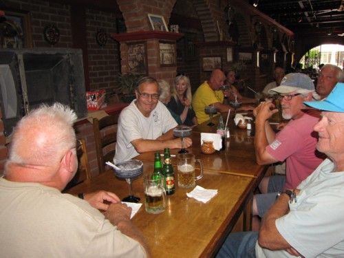
Karl was the first to gather at the common area and get the campfire going. After a while we joined him and then DT and Jill and Roy and Blanche
gathered around, each bringing their own chairs to form a circle that was closed when Tom, Bill and Phil joined us after enjoying their
steak-and-lobster dinner, which they didnt share. Some of us drank wine, others, beer and a few of us shots of tequila with a mixer of orange juice
provided by Karl. We talked about guns, led by Roy. Phil can certainly bring good cheer to any campfire with stories of his smoke-damaged restaurant.
Tom and Bill talked of their desert racing experiences as support crews. But mostly, we talked about how much we enjoy coming to our beloved
peninsula. My boys were the first to bed and were followed shortly by my wife and Jill. The rest of us continued on various subjects for a while
(though politics, thankfully, was avoided) before finding one excuse or another to peel off and go to bed. Toms was the last voice I remember hearing
echo off the rock wall before I drifted to sleep.
When morning arrived, our campsites were provided with shade by the hill to our east for some time after dawn. We leisurely broke camp, some enjoying
an early walk on the beach or a quick dip in the sea. Before departing, the more seasoned members of the convoy went around checking to see that we
all had radio communication with each other. I, for one, didnt. I dont usually caravan on Baja camping trips and obviously have a lot to learn about
the process. Roy graciously provided me with something to join in the airwave chatter. Perhaps around 10 or so we headed out to the highway. The
previous afternoon, Karl had walked a shortcut and wanted to take it back to the main road instead of circling back on a longer route. Dt and Jill
experienced a problem engaging their FWD system and had no choice but to take the long way back. Fortunately, they were able to resolve it by the time
they rejoined the group where the shortcut joined the road.
Karl led us down the road towards Agua Verde, but turned off just short of the last hill before reaching the village. As the convoy crested a small
hill down the road, we came in view of a picture-postcard cove of clear blue-green waters complete with a sailboat at anchor that forms the northern
shore of Bahia Agua Verde. The sight caused lots of appreciative radio chatter as we each saw it in turn. After a quick look around and taking some
photos, we all saddled up and headed back to the main road. My family and I owe a debt of gratitude to Karl. We were running low on water and would
have missed this side trip to go into the village at Agua Verde to replenish our dwindling supply. He generously provided us with four gallons, making
a trip to the village unnecessary.
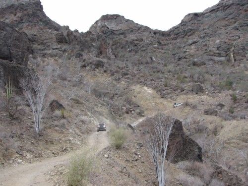
We turned northwest on the main road, bypassing the village and retracing our path a short distance before turning left into a broad arroyo that heads
south and narrows as we go up it. After a short stop to regroup and allow Tom to tighten a sway bar that had been causing a hard-to-ignore knock, we
headed up the grade. Some of us had been looking forward to a challenging, technically difficult ascentsomething that would put their machinery to
the test. I was not one of them, so I was pleased when the grade was quite smooth and uneventful, the better to appreciate the afforded views. When we
reached the upper grade we encountered a couple of guys and a road grader working their way down the slope. They had heard that the road behind us had
some narrow sections and at least one tight turn and they wanted our opinions. Karl handed them a Pacifico (which they cheerfully accepted) while we
told them what we could remember of the trip up. They carried a digital camera, which I asked them about since they hardly seemed the tourist type.
One replied that they took pictures of the work they accomplished each day to get paid. Without the photos, the folks back at the office often accused
them of not working at all.
We headed on up the grade and stopped at the top for a regroup and photo op of the spectacular views of the coastline wed left behind. Karl, whod
been through the area and knew what to expect AND who also had a cool sat.nav/gps system installed in his vehicle, led the way for most of the day,
ably keeping us on the trailonce even ignoring ranchers hollering that we were heading off in the wrong direction. I was sure glad he was right on
that one! It would have been mighty embarrassing if wed had to backtrack through that ranch after ignoring their recommendations. It seems that most
of the trails we wanted to use werent recommended by the localsat least, not by those we met at San Jose de La Noria. I learned to trust Karls
knowledge of the area on that one. When he had doubts, he stopped for group pow wows to reach a consensus on how/where to proceed. The countryside we
drove through was dry, but the temperatures didnt seem overbearing. The roads traveled were in fine shape and made for quick progress as we first
headed away from the coast before dropping down at Rancho Cerritos and joining the road that doubles back to Timbabichi. Somewhere along that stretch,
Roy had to pull over and secure a boot cover of a rear shock, which didnt take long and gave the rest of us a chance to socialize some.
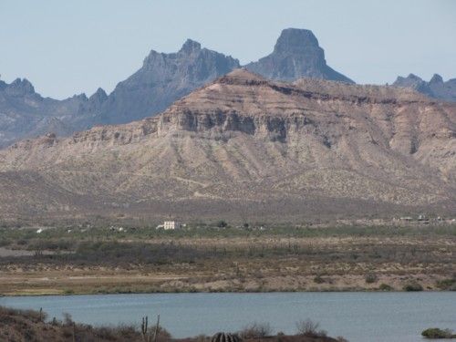
We arrived at the top of the Timbabichi Grade just before sunset, which made for some spectacular lighting of the desert scape we descended through on
our way to the coast. The road takes the long way around to reach the beach. I overheard Phil say that at the ridge his gps indicated we were seven
(?) miles away from our intended destination but we ended up covering over twice that much to reach it. The last few miles went by quickly, probably
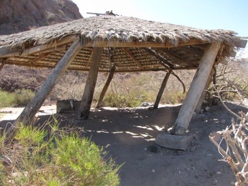
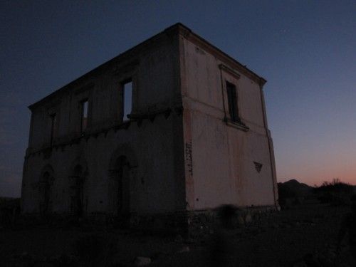
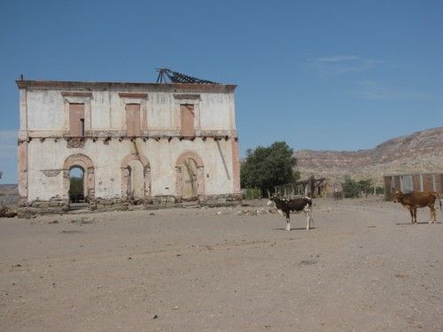
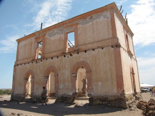
because there wasnt much to see in the gathering darkness. After what seemed like forever, we arrived at the old hacienda at Timbabichi, whichif
memory serves mewas a destination Tom selected since he knew of the very impressive structure located there. Impressive indeed! For anyone familiar
with Baja ranches of the 1960s and before, a place like this out in the middle of nowhere cant help but inspire a WTF!? moment in them when they
first set eyes on it. For us, it was even more so because we arrived at dusk, giving the old building an eerie appearance in the twilight.
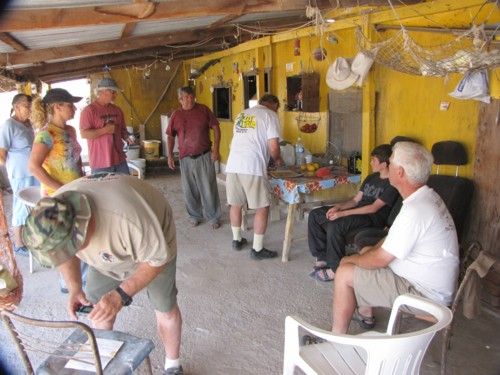
While Tom and his brother Bill and Phil left us to head north on the road paralleling the beach to search for an adequate campsite, the rest of us
poked around the majestic two-story structure for a bit and talked to a local family who said they had some documents of historic significance theyd
be happy to share with us the following morning.
We returned to our vehicles and followed radio instructions and then flashlights to the camp ground on the beach selected by our capable scouts. While
I cant speak for the rest of my fellow travelers, all I cared to do at that point was eat something and hit the sack, which I did. I slept pretty
well, until the grit of sand that was driven through the no-see-um of our tent woke me up. I tried using the rain fly first (no good, too hot and
stuffy) and then our SUV to block some of the sand blast, to little effect. Comes a point you say oh well, and go to sleep.
Morning arrived with no wind and a lightly overcast sky that promised to make the trip out to Highway One even more comfortable than our travel of the
previous day. Before we were all fired up and ready to go, DT went from vehicle to vehicle, ensuring that we all had enough fuel to reach Cd.
Constitucion before emptying his container (Im always impressed by how helpful and thoughtful most Nomads are). After breaking camp, a few of us
returned to the hacienda while others scouted the estuary and some of the coastline beyond before heading back to the building that dominates the
alluvial plain where it sits. Here is a brief summary of what we found out after talking to a few locals, reading their offerings and seeing their
collection of photographs and other documents. In at least one instance these documents contradict each other. The official family history, which is
a single, typed page preserved in a picture frame with a date of Dec. 1995 states that the place was settled in 1901. Yet they also have a US
identification card of a family member who emigrated to California which states that she was born in Timbabichi, Baja California, Mexico in 1887.
For those unfamiliar with Timbabichi (probably most of us), its a small fishing and ranching community on the Gulf Coast between La Paz and
Loretomore precisely, its located between Agua Verde and Rancho Dolores. There are perhaps ten houses in the community, and most (all?) have solar
panels to generate a limited amount of electricity, enough for about half of the village to have satellite TV (one of the families we spoke to said
they werent home when the contract salesperson came through, so they didnt get it). In addition to the old hacienda and the building that served as
its kitchen, there is also an old well on the property that use to provide the community with water. Residents are proud of the rock (brick?) work
inside the well, since a couple of them mentioned it. Today, a tube brings water from two kilometers up arroyo.
The communitys founders were a Señor Donaciano de la Toba, his wife Germana Mesa and the first of their daughters, who were then three and seven
years old. The family took possession of the area in 1901. In the first years, the family likely engaged in subsistence fishing, ranching and
gardening to get by. But the principle reason that brought the family to such a lonely outpost on the peninsula was pearling, which was still the main
economic activity of the southern peninsula.
The familys fortunes changed dramatically in 1906 when don Donaciano found a four-carat green pearl in the nearby Estero del Cochi. In April of that
year he traveled to La Paz on a passing Spanish ship and sold the pearl for 40,000 pesos, which was a considerable sum of money in those days. With
the some of the profit he bought a boat from which to work the pearl beds off Timbabichi.
Lightning struck twice in Timbabichi that year, for a month later don Donaciano found an even larger pearl, this one reportedly weighed five carats
and sold for 50,000 pesos in La Paz. With these profits, don Donaciano bought building materials and contracted brick layers in La Paz to go out to
his property and build the hacienda that we see today. It would be the last of the spectacular pearl finds for don Donaciano. The rest of his pearling
days produced only small samples that didnt matter enough to mention in the family lore.
In its heyday, the hacienda was like a Shangri-La on the parched Baja coastline. The brightly-colored two-story building (with exceptionally high
ceilings, yet) would have shone like a beacon while the lands around the old house were a mass of green, producing grapes, figs, wheat and an
assortment of fruits and vegetables. It became a distribution center for regional trade, connecting the inland ranches with the highway that was the
Sea of Cortez back then. Many small coastal steamers plied the waters between La Paz and Santa Rosalia and stopped at some 11 coastal communities in
between. A warehouse was built to store the products awaiting transportation on a passing ship or to be taken to inland ranches on pack animals. To
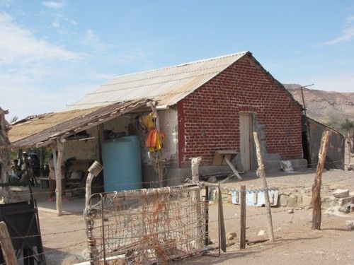
help keep the main house cool, the kitchen was located in a separate building nearby. When pearls ceased to be of major economic importance in the
region, the hacienda was devoted to cattle raising on a large scale. Although the warehouse is long gone, the kitchen today serves as the residence of
members of the de la Toba family.
The couple had twelve daughters and three sons. Timbabichi must have been a healthy place to live since family photographs indicate that mostif not
allof their children reached adulthood (unusual for the time). Although I didnt make a formal inquiry, it seem that most (all?) of the residents had
a connection to the first couple, either through blood or marriage to someone with it. Today, the rectangular building that was once the centerpiece
of an impressive property now stands abandoned and is slowly going to ruin. An effort to restore it was made some years ago, but this only led to
conflicts.
According to members of the family who still live at Timbabichi, some of the daughters of the founding couple married foreigners and settled in the
United States. Apparently, the legend of the familys Shangri-La has been kept alive in the branches that emigrated in the early 1900s, for at least
one such relative has attempted to restore the old property with an eye to developing it for personal profit, displacing the residents who presently
live there. Residents also said another distant American relative tried to sell the property to other Americans, going so far as to produce forged
documents claiming ownership and showing up with federal officials to evict local residents. The locals say they pleaded with the state governor to
intervene, which he did.
At one time an airstrip was available and used by rugged sports fishermen, who flew their small planes down from California and didn't mind staying in
"rustic" accomodations. As late as 1995 there wasn't a road linking the hacienda with the Transpeninsular Highway, which meant that locals were still
depended on the seaway at their doorstep for transportation.
Anyway, that is the summation of what locals say about their place.
Sometime shortly after 12, we said goodbye to our newfound friends, leaving behind a generous variety of groceries to the two families that had hosted
us. The Timbabichi Grade is equally spectacular going up, but the previous days late-afternoon lighting was better for photos. Since we knew the way
with certainty on the return trip, we made good time as we passed active and abandoned ranches in the sierra. We stopped and chatted with a local
rancher at Rancho Los Batequitos, who proved very informative about local government programs and other topics. He (like people we met everywhere) was
pleased to see us go by, assuring us that tourists were perfectly safe in Bajas ranch country and wished more of us would come out to see what this
part of the peninsula has to offer. After saying our goodbyes to this friendly fellow, we were on our final leg of the adventure as a group. We gassed
and aired up when we reached Cd. Constitucion and then Tom asked the attendant to recommend a good restaurant in town, which he did. We all met up at
Asadero something-or-other (again, the name thing), where we had a drink to wash down the road dust, ate our fill, and talked about the experience.
Shortly after wed all finished eating, DT and Jill got the ball rolling when they said they had to hit the road in order to take advantage of the
daylight left; they were returning to Buena Vista and it was getting late. Karl and my family headed down to La Paz while Tom and Bill and Phil headed
up to La Purisima for the night. We arrived in La Paz just as the sun was setting, saying our goodbyes to Karl at El Centenario before heading on
home.
The End
Our campsite near Agua Verde
The marker that said "We're Here"
My boys enjoyed the peaceful waters around us
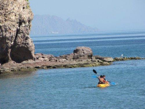
A seascape on the point
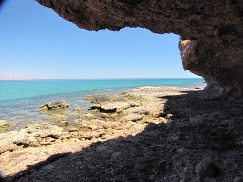
What the cave we visited looks like from below. A good trail connects the dirt road to it.
The images left behind by Native Americans
A view from the cave's opening
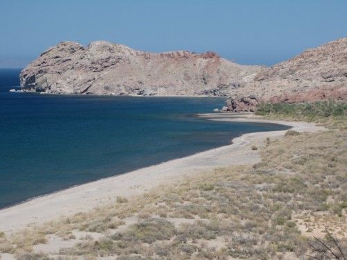
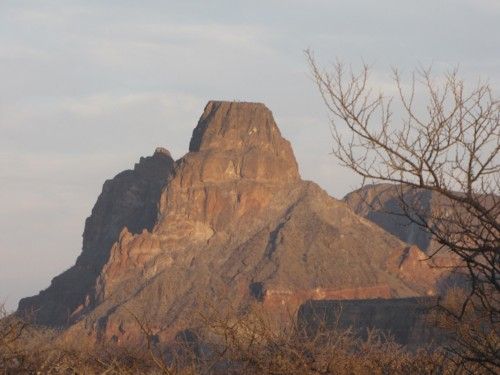
Roca Solitaria, the white one, in front of the village at Agua Verde
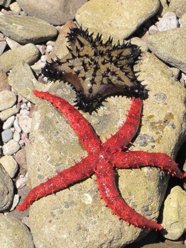
A couple of local coral eaters brought up for viewing by one of the boys.
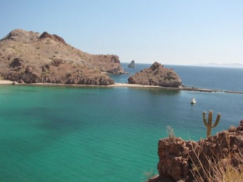
Karl's secret little cove he shared with us. Roca Solitaria is the small island in the "V."
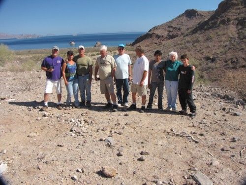
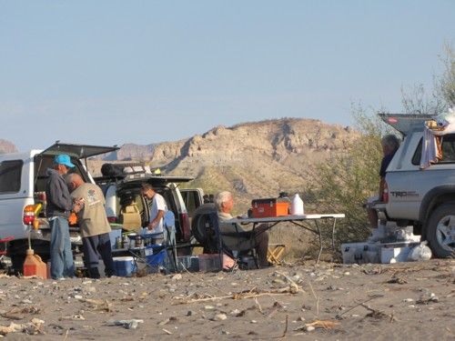
Most of the crew assembled
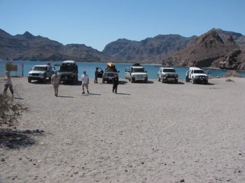
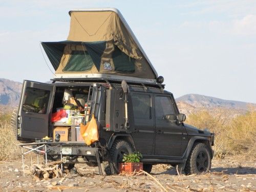
Our mounts
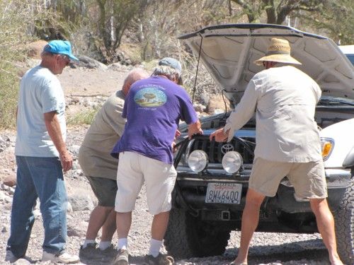
Never a shortage of hands willing to get dirty helping out a fellow Nomad
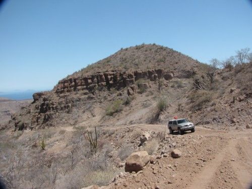
Phil powers up the grade leaving Agua Verde
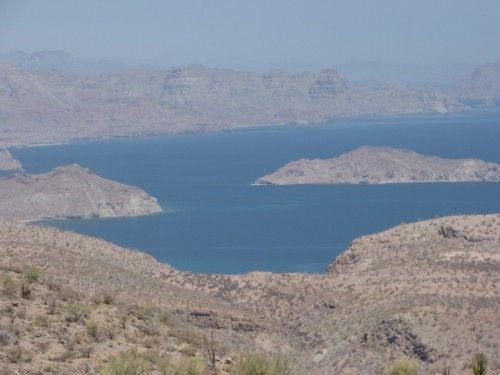
A view looking at the beaches we left behind
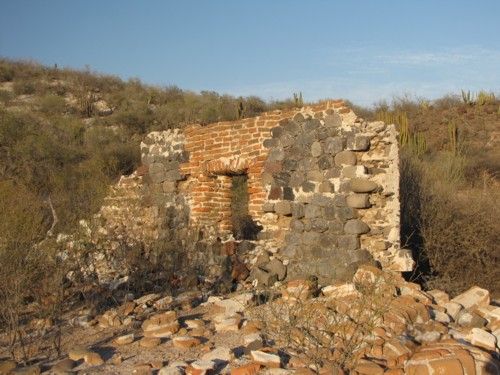
The old Rancho (Hacienda?) Tijuana ruins on the way to Timbabichi. The material seems to indicate some pretty old construction
Late afternoon light as we head into Timbabichi
As the hacienda looked on our arrival
Our campsite on the beach at Timbabichi
Those Germans, ready for anything
The hacienda's place in the landscape
The old hacienda house, sea side
How it is seen when approached from the road
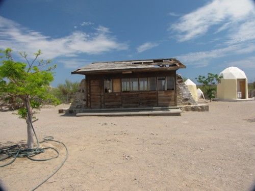
What use to be the hacienda's kitchen, now it houses a family
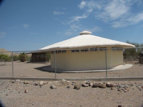
The new school house at Timbabichi, with the old wooden one, no longer in use, in the background. 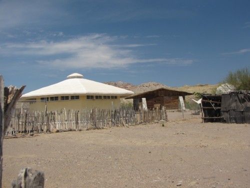
We invaded the front porch of a local house
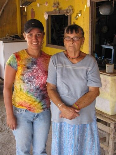
The hacienda house was still occupied during the elder lady's lifetime since she was born in it.
Roy and Blanche head up a section of the Timbabichi Grade while Dt and Jill await their turn
A round of cheer at the end of the trail
Something no doubt my fellow Nomads will begin noticing in their back-country travels. These HAVE to be part of a new government effort to spend
money. They've spread like a plague
[Edited on 5-8-2012 by Bajatripper]
There most certainly is but one side to every story: the TRUTH. Variations of it are nothing but lies.
|
|
|
Jack Swords
Super Nomad
Posts: 1094
Registered: 8-30-2002
Location: Nipomo, CA/La Paz, BCS
Member Is Offline
|
|
Very nice, enjoyed it. Any connection between the local family and Fernando de la Toba, Baja Sur's first governor?
The hacienda is a landmark when sailing down the SOC, very visible from sea.
|
|
|
Bajatripper
Ultra Nomad
Posts: 3145
Registered: 3-20-2010
Member Is Offline
|
|
| Quote: | Originally posted by Jack Swords
Very nice, enjoyed it. Any connection between the local family and Fernando de la Toba, Baja Sur's first governor?
The hacienda is a landmark when sailing down the SOC, very visible from sea. |
Thanks, Jack.
Can't say that it came up in conversations, but they do acknowledge a kinship with the de la Tobas' of San Luis Gonzaga, if that's of any help.
I can only imagine what it must look like from the sea and would have loved to have seen it in its better days.
I was surprised not to read any reference to it in Fernando Jordan's Mar Roxo de Cortez, his account of sailing a 21 foot open boat from La
Paz to San Felipe, past those very shores.
[Edited on 5-5-2012 by Bajatripper]
There most certainly is but one side to every story: the TRUTH. Variations of it are nothing but lies.
|
|
|
Fernweh
Nomad
Posts: 444
Registered: 2-24-2011
Location: Centenario, BCS
Member Is Offline
|
|
Thank you Steve for this incredible trip report.
It is always a great pleasure to read your so informative postings.
A big Thank You to all of you, making the trip such a memoriable adventure. What a wonderful group of Baja Nomads I was able to join. As Steve
mentioned in his report, the drive to Timbabichi was a long grueling one for sure. We did encountered some beautiful landscapes on our way and I was
always amazed by the work and effort from the rancheros in their small green islands among the large desert sea.
Nice pictures posted, capturing this adventure perfectly. I will add some additional ones from the lonely beaches just to the north of our campsite at
the Timbabichi beach......
Thanks again Steve, also for not mention the many times I had to back up out of a wrong turn/direction taken.
|
|
|
shari
Select Nomad
Posts: 13033
Registered: 3-10-2006
Location: bahia asuncion, baja sur
Member Is Offline
Mood: there is no reality except the one contained within us "Herman Hesse"
|
|
whew...finally...we've all been waiting for this story and it sounds terrific and a true baja adventure. We have been wanting to make the trip for
years so it's nice to actually see it and hear about it...how many hours was it from agua verde to Timbabichi? pretty cool that nobody got hurt or
trashed their mounts...way to go Karl for being so preared and good on all of you for getting out there and doing what most just dream of.
|
|
|
David K
Honored Nomad
Posts: 64479
Registered: 8-30-2002
Location: San Diego County
Member Is Offline
Mood: Have Baja Fever
|
|
Oh man, how great and out of the norm route. I believe it was Arnold Senterfitt who said there used to be a cardon cactus on the roof of the hacienda
40 years ago? Back then you could get there by boat or by airplane... no road.
|
|
|
Bajaboy
Ultra Nomad
Posts: 4375
Registered: 10-9-2003
Location: Bahia Asuncion, BCS, Mexico
Member Is Offline
|
|
looks like a great trip. We used to camp near the old Johnson place by the palapa. Lots of great memories...in fact, I proposed to my wife there one
Christmas morning years ago.....luckily for me she said yes.
Thanks for sharing.
Zac
|
|
|
Bajatripper
Ultra Nomad
Posts: 3145
Registered: 3-20-2010
Member Is Offline
|
|
| Quote: | Originally posted by Bajaboy
We used to camp near the old Johnson place by the palapa..
Zac |
As someone always on the alert for local history, I'd be interested in hearing what you know about "the old Johnson place by the palapa."
There most certainly is but one side to every story: the TRUTH. Variations of it are nothing but lies.
|
|
|
Bajatripper
Ultra Nomad
Posts: 3145
Registered: 3-20-2010
Member Is Offline
|
|
| Quote: | Originally posted by Fernweh
Thanks again Steve, also for not mention the many times I had to back up out of a wrong turn/direction taken. |
You mean there were other times? I was usually so far behind, I didn't notice it but once.
Well then...I'll have to revise my report!
There most certainly is but one side to every story: the TRUTH. Variations of it are nothing but lies.
|
|
|
Bajaboy
Ultra Nomad
Posts: 4375
Registered: 10-9-2003
Location: Bahia Asuncion, BCS, Mexico
Member Is Offline
|
|
| Quote: | Originally posted by Bajatripper
| Quote: | Originally posted by Bajaboy
We used to camp near the old Johnson place by the palapa..
Zac |
As someone always on the alert for local history, I'd be interested in hearing what you know about "the old Johnson place by the palapa."
|
I don't recall too much info but it was related to me here on Nomads. There used to be a really nice trailer down there with lots of interesting
living areas. I'm pretty certain they put in the palapa. I was told the couple had two place in Baja and lived between both of them. Sounds like
they had been there for a long time.
We camped there again in 03 or so and the trailer had been abandoned but only recently. It was a bit spooky as there were still plenty of belongings
around but the place had been ransacked. From what I recall, one of them had passed or became ill and abandoned the place.
That's all I know but I'm sure someone else can pipe in about the place.
|
|
|
woody with a view
PITA Nomad
Posts: 15937
Registered: 11-8-2004
Location: Looking at the Coronado Islands
Member Is Offline
Mood: Everchangin'
|
|
it really sucks being so far north. great trip report BTW!
|
|
|
TMW
Select Nomad
Posts: 10659
Registered: 9-1-2003
Location: Bakersfield, CA
Member Is Offline
|
|
Excellent report, thanks Steve. It was Steve that communicated so effectively with the locals and was able to translate it to us so we had a much
better picture of their life and history.
|
|
|
Pescador
Ultra Nomad
Posts: 3587
Registered: 10-17-2002
Location: Baja California Sur
Member Is Offline
|
|
| Quote: | Originally posted by David K
Oh man, how great and out of the norm route. I believe it was Arnold Senterfitt who said there used to be a cardon cactus on the roof of the hacienda
40 years ago? Back then you could get there by boat or by airplane... no road. |
When I flew in there last time in '87, there were three cardon's on the roof. Two pretty small and one larger one. It is really interesting to see
that the old wood building for the school is still standing. When the government first built it they had ropes over the roof with winches. When
the wind blew in from the south, they loosened the North side winches, cranked down on the south side to make the building square, or reasonably so,
and then did the opposite in the winter with the north winds.
|
|
|
David K
Honored Nomad
Posts: 64479
Registered: 8-30-2002
Location: San Diego County
Member Is Offline
Mood: Have Baja Fever
|
|
| Quote: | Originally posted by Pescador
| Quote: | Originally posted by David K
Oh man, how great and out of the norm route. I believe it was Arnold Senterfitt who said there used to be a cardon cactus on the roof of the hacienda
40 years ago? Back then you could get there by boat or by airplane... no road. |
When I flew in there last time in '87, there were three cardon's on the roof. Two pretty small and one larger one. It is really interesting to see
that the old wood building for the school is still standing. When the government first built it they had ropes over the roof with winches. When
the wind blew in from the south, they loosened the North side winches, cranked down on the south side to make the building square, or reasonably so,
and then did the opposite in the winter with the north winds. |
How cool! Thanks for that!!
|
|
|
Bajatripper
Ultra Nomad
Posts: 3145
Registered: 3-20-2010
Member Is Offline
|
|
| Quote: | Originally posted by Pescador
When I flew in there last time in '87, there were three cardon's on the roof. Two pretty small and one larger one. It is really interesting to see
that the old wood building for the school is still standing. When the government first built it they had ropes over the roof with winches. When
the wind blew in from the south, they loosened the North side winches, cranked down on the south side to make the building square, or reasonably so,
and then did the opposite in the winter with the north winds. |
Yeah, the locals told us the same stories. I'd noticed the stone supports and at first thought there must have been something else there first, much
older. I was surprised to find out that they were put in after the wooden structure was built because of a defect in the building's design.
Notice stone/concrete supports, added after the fact.
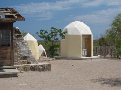
The locals are quite proud of their new school house. The person I spoke with said that it's a prototype for what could become the new
standard for rural schools in Baja.
He said the architect lives in La Paz and couldn't say enough about their new school "con baño y todo." Probably helps take some of the stigma off of
having been known for that other "unusual" school house. He did mention that tourists frequently took pictures of the older building.
The new school house
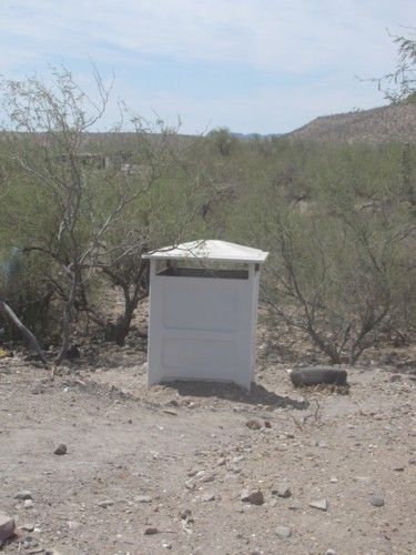
Its adjacent bathroom facility
There most certainly is but one side to every story: the TRUTH. Variations of it are nothing but lies.
|
|
|
BajaBlanca
Select Nomad
Posts: 13165
Registered: 10-28-2008
Location: La Bocana, BCS
Member Is Offline
|
|
loved the reading and the photos !
|
|
|
Fernweh
Nomad
Posts: 444
Registered: 2-24-2011
Location: Centenario, BCS
Member Is Offline
|
|
Here are some photos from the hidden beach in Timbabichi.
Yes it was a long day driving those Baja back roads. We made it to the village just in time before the night fell, and we camped more or less at the
first beach in sight.

Manuel, the local lobster guy had told me about the "nicer" beach, just a few kilometers further north.....and next morning I had to look for it.

A very beautiful beach with a sail boat anchored in the little protected harbor. The fine sand, the crystal clear waters and the impressive sand stone
outcroppings made this place a definite return-to-destination.


Back from the Timbabichi adventure, I really earned a long rewind session at one of my favorite waterholes in La Paz.

|
|
|
LaPazGringo
Nomad
Posts: 237
Registered: 2-28-2012
Location: La Paz
Member Is Offline
|
|
Very, very interested in your route and enjoyed immensely each pic and your report. I've been looking at the Baja Almanac each evening planning how
I'm gonna do it. I'd love to head to San Evaristo, take the road West past the mission to Hwy 1 and up to Agua Verde. Anyone have any knowledge of the
condition of the road from San Evaristo west to the hwy?
|
|
|
TMW
Select Nomad
Posts: 10659
Registered: 9-1-2003
Location: Bakersfield, CA
Member Is Offline
|
|
Thanks Fernweh for coming along. Having you and Bajatripper with us was a real treat with Baja memories for a life time.
|
|
|
edm1
Senior Nomad
Posts: 568
Registered: 8-23-2006
Location: Oak Hills, Ca
Member Is Offline
|
|
Steve, well written account of events.Thanks for taking the time to share to us who couldn't come. Great photos, too. But where are the steep grades
and narrow/tight passes?
About the new schoolhouse . . . Do they have anything against school children going near windows? That building looks like jail :-)
[Edited on 5-7-2012 by edm1]
|
|
|
| Pages:
1
2 |
|