| Pages:
1
2 |
David K
Honored Nomad

Posts: 64479
Registered: 8-30-2002
Location: San Diego County
Member Is Offline
Mood: Have Baja Fever
|
|
The town? What town?
Thanks!
|
|
|
4x4abc
Ultra Nomad
Posts: 4163
Registered: 4-24-2009
Location: La Paz, BCS
Member Is Offline
Mood: happy - always
|
|
that's what I though - Matomi
Harald Pietschmann
|
|
|
David K
Honored Nomad
Posts: 64479
Registered: 8-30-2002
Location: San Diego County
Member Is Offline
Mood: Have Baja Fever
|
|
So, how about Aguaje Santa Isabel?
|
|
|
fishsticker
Junior Nomad
Posts: 74
Registered: 8-23-2008
Member Is Offline
Mood: Margarita Time
|
|
check u2u
|
|
|
David K
Honored Nomad
Posts: 64479
Registered: 8-30-2002
Location: San Diego County
Member Is Offline
Mood: Have Baja Fever
|
|
Thank you fishsticker.
Still waiting, if there is any answers from Harald & Tioloco...?
Been reading more and more on Consag... More like reading again... May make an interesting article?
In short, the head Jesuit in California (Padre Juan Antonio Balthasar) said he (and his superior) wanted to settle the question of California being an
island or not, once and for all. Also, how best to supply new missions in the north of the peninsula. Padre Consag went to task and organized
expeditions to the north of his mission of San Ignacio.
The sailing voyage from San Carlos (on the Baja coast near the 28th parallel) to the Colorado River began on June 9, 1746.
The next was overland up the center of the peninsula and over to the Pacific, in May 22, 1751 beginning at La Piedad (which became Mission Santa
Gertudis the following year).
The third expedition was in 1753, also overland, but stayed closer to the gulf coast getting as far north as the region of Gonzaga Bay. Never finding
an ideal mission site, Consag also missed seeing the spring of Adac, which became Mission San Borja in 1762.
|
|
|
David K
Honored Nomad
Posts: 64479
Registered: 8-30-2002
Location: San Diego County
Member Is Offline
Mood: Have Baja Fever
|
|
Thank you... I will look forward to that Volume 57 article when it becomes available, online.
I appreciate any references to the explorers of Baja's past! 
|
|
|
4x4abc
Ultra Nomad
Posts: 4163
Registered: 4-24-2009
Location: La Paz, BCS
Member Is Offline
Mood: happy - always
|
|
David,
any idea what "La Visitacion" above Gonzaga bay is?
Harald Pietschmann
|
|
|
David K
Honored Nomad
Posts: 64479
Registered: 8-30-2002
Location: San Diego County
Member Is Offline
Mood: Have Baja Fever
|
|
Read it in Consag's diary, beginning on page 70 (translated into English in this book as [La] Visitation):
https://archive.org/stream/lifeworksofrever00kons#page/70/mo...
I asked this of you a few posts up in this thread:
"I would like you opinion of what the Aguaje Santa Isabel was... My opinion is Agua del Mezquitito, about 15 miles north of Papa Fernandez'."
[Edited on 11-6-2015 by David K]
|
|
|
4x4abc
Ultra Nomad
Posts: 4163
Registered: 4-24-2009
Location: La Paz, BCS
Member Is Offline
Mood: happy - always
|
|
I am still in the process of collecting information.
Don't really have an opinion yet.
The place has 3 different names:
Aguaje Santa Isabel
Agua del Mezquito
La Vistiacion
I know the area well
The Camino Real goes in and out at several locations
I found strong evidence for prolonged use by the padres
Harald Pietschmann
|
|
|
Cliffy
Senior Nomad
Posts: 984
Registered: 12-19-2013
Member Is Offline
|
|
It would have been so much easier for them if they had just used an old AAA map, wouldn't it? I still have mine :-)
This is a fascinating thread.
You chose your position in life today by what YOU did yesterday
|
|
|
David K
Honored Nomad
Posts: 64479
Registered: 8-30-2002
Location: San Diego County
Member Is Offline
Mood: Have Baja Fever
|
|
Quote: Originally posted by 4x4abc  | I am still in the process of collecting information.
Don't really have an opinion yet.
The place has 3 different names:
Aguaje Santa Isabel
Agua del Mezquito
La Vistiacion
I know the area well
The Camino Real goes in and out at several locations
I found strong evidence for prolonged use by the padres |
I would love to see what you have for evidence. I do know that the construction crew for Hwy. 5 had to stop for archeologists to remove artifacts when
they 'found' an Indian village remains, just south of El Huerfanito, south side of long bridge. Perhaps that was La Visitacion?
You know I am picky on details, right?
The "area" has several names, yes... are they the same place? Not likely.
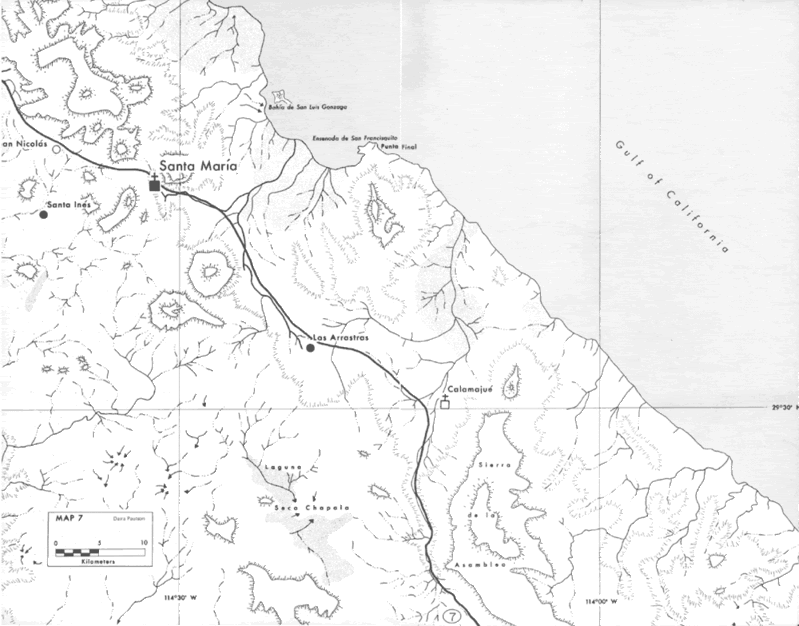
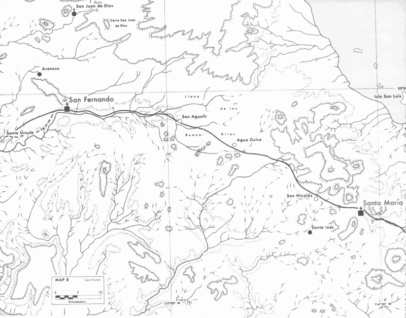
The Camino Real is closest to Gonzaga Bay at the Arroyo Santa María crossing before going up to Mission Santa María. It then heads across Baja to Agua
Dulce and Mission San Fernando and not up the gulf coast.
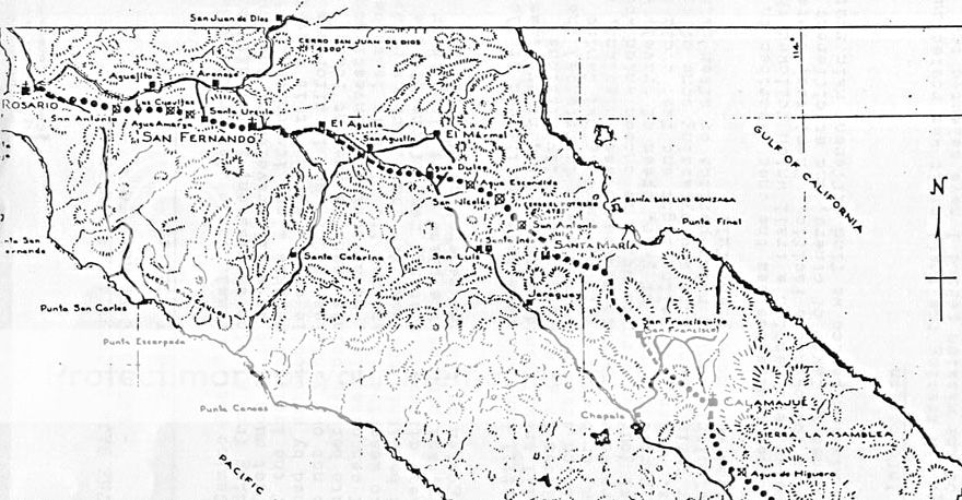
Gulick 1954
Crosby 1977
|
|
|
David K
Honored Nomad
Posts: 64479
Registered: 8-30-2002
Location: San Diego County
Member Is Offline
Mood: Have Baja Fever
|
|
The El Camino Real beyond (north from) San Borja was never much more that an animal track and not the wide, well-constructed road that the Jesuits
designed. There are some small switchbacks on the trail near Mission Santa Maria. Very little north of San Borja can be seen on Satellite images. San
Borja south to San Javier is a much different story, where the old road is easily seen for many long stretches. Switchbacks coming down the mountain
graded or into/out of canyons, as well!
Here is a cuesta on El Camino Real, north of San Ignacio, dropping down to Santa Marta...

|
|
|
| Pages:
1
2 |