Floatflyer
Nomad

Posts: 314
Registered: 2-15-2009
Location: Whidbey Island, WA
Member Is Offline
Mood: Wet & Cold
|
|
Las Naranjas Road Trip
A week ago yesterday my wife, dog, and I decided to get away from the cloudy and windy East Cape for awhile. We decided to drive over the Sierra de
La Laguna Mountains. We got to the intersection of Mex 1 and the dirt road which is just north of the San Jose Prison turn off. There is a cloth
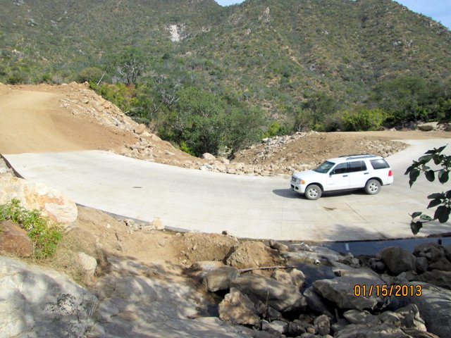
sign there that says "Presa La Palma". We headed west at about 10:30am on this wide and smoothly graded dirt road. You could easily drive a
passenger car on this western side of the mountain road. It seems this road is the access for the construction of a dam in the lower foothills.
Numerous groups of workers are installing re-enforced concrete linings to many vados to prevent runoff damage.


You continue up this nice road for approximately 9 miles and here you will see another cloth sign "Presa La Palma" with an arrow pointing to the
right. The road takes a 90 degree turn and appears to head downward towards the dam site which I could only see some dirt work a mile or so away. We
continued to straight and went over a small hump and started downward on a more "normal" Mexican one lane + dirt back road. At this point I was still
saying a decent driver in a passenger car would be fine. I had talked to a guy who had recently taken his motorcyle over this road and he issued a
few cautions. I took a shovel and a big pry bar with me in our Explorer just in case.

We continued down this road with no problems until about 16.4 miles into the trip. Here we encountered the first signs of road damage, still not a
problem

Next we started encontering run off caused ruts that were going down hill for 30-40 feet, maybe 12-15" deep and I needed to slow way down to get thru
them. I did not need 4 wd but used low range to help brake as I went thru them. NOW I would recommend that a high clearance vehicle would be a good
idea. If you goofed up you could get hi centered. Coming out of some of these ruts you needed to go up rough little grades and 4 wd makes this
easier at a slower speed. Without 4wd you would have to accelerate up these and get bounced around a bit, your choice.
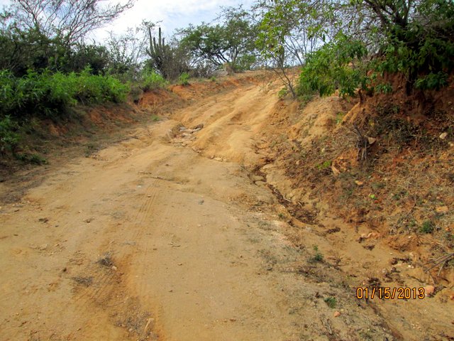

These conditions continue on and off for the next 4.5 miles roughly, 20.9 miles from the Mex 1 intersection.
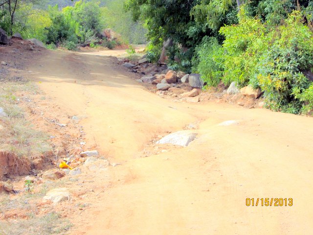
The next semi challenge is when you reach Rancho El Aguaje. Here you "t-bone" into a dirt road and have the choice of going left or right. There is
a sign that names the ranch. I was told to go right or you will wander around for hours, I don't know, I went right! By this time you are on
basically flat terrain.


From here it is just a matter of following a fairly nice dirt road, and now, passenger car friendly. You have to make an educated guess on a couple
of forks but really it isn't very hard to pick the main road. You hit Mex 19 right across the street from Rancho Nuevo, a development south of
Cerritios and Todos Santos.
Total distance 32.9 miles and for us 2:45 min. We only stopped for a pee stop or two and a taking some pictures. I did not drive fast nor did I
drive slow. I would say I drove at a comfortable and safe speed. The 2 spots I would think about if I had a longer wheel based vehicle was in going
around a couple large 2'x4' boulders that had rolled onto the road. I was a little careful not to scrape the side of my car. We are not thrill
seekers! Both my wife and I agree that this trip had no life threatening experiences but a bit of caution is needed. IF one was to travel from west
to east a serious 4wd vehicle would be needed to uphill thru the rough spots. I would not go that direction. Overall, the east half of the trip was
very easy for anybody and had the prettiest scenery. The west side is definitely more challenging and 4wd would be best. If you were a very
experienced off road driver and had a high clearance vehicle you probably be ok.
I had looked at the route on Google Earth before the trip and had a general idea of where I was going. I wrote down some GPS #s at some
intersections and that was ok, pretty much a double check I was going in the right direction but not a mandatory need.
So, we probably won't do this every year, for us it is like the coast road from La Ribera to San Jose, fine every other year or so. The eastern part
of the drive would be a nice picnic trip, no stress. Hope this helps out. FF
|
|
|
TMW
Select Nomad
Posts: 10659
Registered: 9-1-2003
Location: Bakersfield, CA
Member Is Offline
|
|
Great thanks for sharing.
|
|
|
motoged
Elite Nomad
Posts: 6481
Registered: 7-31-2006
Location: Kamloops, BC
Member Is Offline
Mood: Gettin' Better
|
|
It's a nice drive.....is the Buddhist monastery still up there on the east side of the pass?
Don't believe everything you think....
|
|
|
bajalorena
Nomad
Posts: 141
Registered: 3-31-2009
Location: BuenaVista, BCS
Member Is Offline
|
|
Good report, Ford. We did it about 12 years ago. Might have to try it again this year, especially if this wind keeps beating the crap out of us. 
|
|
|
David K
Honored Nomad
Posts: 65549
Registered: 8-30-2002
Location: San Diego County
Member Is Offline
Mood: Have Baja Fever
|
|
| Quote: | Originally posted by Floatflyer
A week ago yesterday my wife, dog, and I decided to get away from the cloudy and windy East Cape for awhile. We decided to drive over the Sierra de
La Laguna Mountains. We got to the intersection of Mex 1 and the dirt road which is just north of the San Jose Prison turn off. There is a cloth
sign there that says "Presa La Palma". We headed west at about 10:30am on this wide and smoothly graded dirt road. You could easily drive a
passenger car on this western side of the mountain road. It seems this road is the access for the construction of a dam in the lower foothills.
Numerous groups of workers are installing re-enforced concrete linings to many vados to prevent runoff damage.

You continue up this nice road for approximately 9 miles and here you will see another cloth sign "Presa La Palma" with an arrow pointing to the
right. The road takes a 90 degree turn and appears to head downward towards the dam site which I could only see some dirt work a mile or so away. We
continued to straight and went over a small hump and started downward on a more "normal" Mexican one lane + dirt back road. At this point I was still
saying a decent driver in a passenger car would be fine. I had talked to a guy who had recently taken his motorcyle over this road and he issued a
few cautions. I took a shovel and a big pry bar with me in our Explorer just in case.
We continued down this road with no problems until about 16.4 miles into the trip. Here we encountered the first signs of road damage, still not a
problem
Next we started encontering run off caused ruts that were going down hill for 30-40 feet, maybe 12-15" deep and I needed to slow way down to get thru
them. I did not need 4 wd but used low range to help brake as I went thru them. NOW I would recommend that a high clearance vehicle would be a good
idea. If you goofed up you could get hi centered. Coming out of some of these ruts you needed to go up rough little grades and 4 wd makes this
easier at a slower speed. Without 4wd you would have to accelerate up these and get bounced around a bit, your choice.

These conditions continue on and off for the next 4.5 miles roughly, 20.9 miles from the Mex 1 intersection.
The next semi challenge is when you reach Rancho El Aguaje. Here you "t-bone" into a dirt road and have the choice of going left or right. There is
a sign that names the ranch. I was told to go right or you will wander around for hours, I don't know, I went right! By this time you are on
basically flat terrain.


From here it is just a matter of following a fairly nice dirt road, and now, passenger car friendly. You have to make an educated guess on a couple
of forks but really it isn't very hard to pick the main road. You hit Mex 19 right across the street from Rancho Nuevo, a development south of
Cerritios and Todos Santos.
Total distance 32.9 miles and for us 2:45 min. We only stopped for a pee stop or two and a taking some pictures. I did not drive fast nor did I
drive slow. I would say I drove at a comfortable and safe speed. The 2 spots I would think about if I had a longer wheel based vehicle was in going
around a couple large 2'x4' boulders that had rolled onto the road. I was a little careful not to scrape the side of my car. We are not thrill
seekers! Both my wife and I agree that this trip had no life threatening experiences but a bit of caution is needed. IF one was to travel from west
to east a serious 4wd vehicle would be needed to uphill thru the rough spots. I would not go that direction. Overall, the east half of the trip was
very easy for anybody and had the prettiest scenery. The west side is definitely more challenging and 4wd would be best. If you were a very
experienced off road driver and had a high clearance vehicle you probably be ok.
I had looked at the route on Google Earth before the trip and had a general idea of where I was going. I wrote down some GPS #s at some
intersections and that was ok, pretty much a double check I was going in the right direction but not a mandatory need.
So, we probably won't do this every year, for us it is like the coast road from La Ribera to San Jose, fine every other year or so. The eastern part
of the drive would be a nice picnic trip, no stress. Hope this helps out. FF |
Wonderful to hear... thanks!
(I hope I fixed some of your photo links... there was some double http:// in a few)
|
|
|
|


