| Pages:
1
2
3
4 |
BigBearRider
Super Nomad

Posts: 1299
Registered: 4-30-2015
Location: Big Bear, Punta Chivato, and Cabo
Member Is Offline
Mood: 
|
|
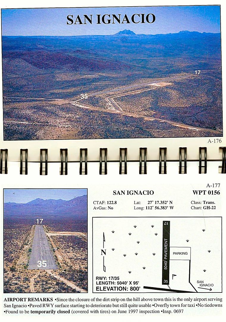
Interstingly, the current WAC-22 chart shows the airport in San Ignacio north of Mex 1 to be open. It's not, and by the looks of it, hasn't been for
a long while.
|
|
|
David K
Honored Nomad
Posts: 64480
Registered: 8-30-2002
Location: San Diego County
Member Is Offline
Mood: Have Baja Fever
|
|
The paved runway north of Hwy. 1 (just west of San Ignacio) had been signed on Hwy. 1. Being so close to the military checkpoint, I would think it
could stay open? Is it 'ditched' with tires across the runway or worse?
I just looked at Galen's book, he said the airport was temporarily closed (covered with tires) in June 1997. So sad for a 5,000 ft paved runway!
|
|
|
BigBearRider
Super Nomad
Posts: 1299
Registered: 4-30-2015
Location: Big Bear, Punta Chivato, and Cabo
Member Is Offline
Mood:
|
|
The sign is still there. I didn't see any ditching, but there are tires all over the runway.
|
|
|
MontyF
Junior Nomad
Posts: 25
Registered: 3-21-2004
Member Is Offline
|
|
Anyone remember Alfonsina's auxilliary landing strip?
Was located few hundred yards to the west of main runway
with a slight dogleg. kind of deep sand. short
Not a great alternative when runway was flooded but doable.
|
|
|
David K
Honored Nomad
Posts: 64480
Registered: 8-30-2002
Location: San Diego County
Member Is Offline
Mood: Have Baja Fever
|
|
Arnold didn't document it. Was it between the lagoon and the main road?
|
|
|
4x4abc
Ultra Nomad
Posts: 4163
Registered: 4-24-2009
Location: La Paz, BCS
Member Is Offline
Mood: happy - always
|
|
29°47'45.62"N, 114°24'3.45"W
Harald Pietschmann
|
|
|
David K
Honored Nomad
Posts: 64480
Registered: 8-30-2002
Location: San Diego County
Member Is Offline
Mood: Have Baja Fever
|
|
Thank you. I can see that would be handy when it's a high lunar tide, and before Rancho Grande made its pair of runways.
|
|
|
David K
Honored Nomad
Posts: 64480
Registered: 8-30-2002
Location: San Diego County
Member Is Offline
Mood: Have Baja Fever
|
|
Back to the 1975 map...
If you would like to see the page(s) for any airport on the map, just ask!
The name and/or the airport # is all I need.
There also is a thread in the Private Aircraft Travel forum here with Google Earth views of many airport sites in northern Baja. From 2009 & 2010:
Part 1 (San Felipe region south to the Bahia de los Angeles region): http://forums.bajanomad.com/viewthread.php?tid=43077
Part 2 (Baja California from the L.A. Bay highway junction with Mex. 1 and south to the state border): http://forums.bajanomad.com/viewthread.php?tid=44822
Part 3 (Ensenada to Laguna Chapala, north to south): http://forums.bajanomad.com/viewthread.php?tid=44848
|
|
|
BajaTed
Senior Nomad
Posts: 859
Registered: 5-2-2010
Location: Bajamar
Member Is Offline
|
|
In 1969 I flew in a 182 to Mulege. The hotel runway back then had cows on it and we had to do multiple buzz dives to get them to move. As we were
getting stuff for our camping trip we noticed a buzz of people around a freshly butchered cow hanging in a small building. We bought a chunk of the
tenderloin and learned why they age beef.
We hired a guy to take us to La Serinidad in a stake bed truck. Deal was to come back and pick us up in a three days. We didn't trust the guy much so
we kept some of the truck bed stake sides to make sure he would return. Back then there wasn't a single building anywhere around the beach and the
carved rock graffiti was really old. Flying fish landing on your sleeping bag in the morning was fun.
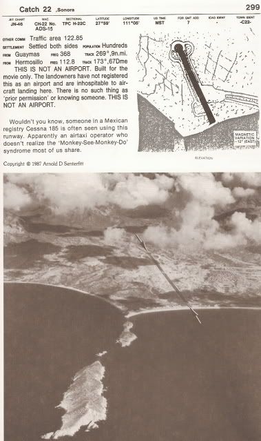
On the way back we landed @ San Carlos where they filmed the movie Catch 22. A Chubasco came through and we spent a night hanging on to the plane so
it wouldn't flip over. One of my best Baja trips for sure, definitely a relive scenario in the nursing home
Es Todo Bueno
|
|
|
David K
Honored Nomad
Posts: 64480
Registered: 8-30-2002
Location: San Diego County
Member Is Offline
Mood: Have Baja Fever
|
|
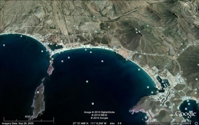
Great story! The Catch-22 runway was visible for years, even on Google Earth, until development finally consumed the area.
Here is a post I made in 2012...
Here is the runway as shown in Senterfitt's book:
You can still see most of the runway in a 2005 satellite photo:
The film was released in 1970... What fun to have been there to see all those bombers taking off! I guess it's time to watch the classic film, again!
|
|
|
| Pages:
1
2
3
4 |


