| Pages:
1
..
81
82
83
84
85
..
116 |
pappy
Senior Nomad

Posts: 679
Registered: 12-10-2003
Member Is Offline
|
|
what is the possibilty of bringing in an ultra lite type airplane/glider for a look see from the sky above?
|
|
|
David K
Honored Nomad
Posts: 64523
Registered: 8-30-2002
Location: San Diego County
Member Is Offline
Mood: Have Baja Fever
|
|
| Quote: | Originally posted by EnsenadaDr
There is a guy I recommended to Lizard. His name is Ralph Shoemaker. He runs the RV park at Santa Ines a few miles south of Catavina. I read he
knows the area like the back of his hand, obviously he is a Gringo with that name. I did send an email to Hotel La Mision in Catavina and got a
response from a worker there who said he see if he could contact Ralph. Obviously LL is aware of this and he and the family makes all the final
decisions. |
Ralph doesn't run an RV park! He is a retired guy who lives part time near Rancho Santa Ynez. He communicates on a HAM radio and has assisted people
having problems getting to Mission Santa Maria. The camp area at Rancho Santa Ynez has no hook ups and has been managed by Oscar and Matilda at Santa
Ynez (last I knew). The RV park is in Cataviña, just north of the Hotel Mision Cataviña.
On another post... TS and ST have been mixed up! Please don't abbreviate to just two letters... The town about 30 miles south of Ensenada is SANTO
TOMAS (ST) not Todos Santos (TS). There is a 'LA BOCANA' on the coast west from Santo Tomas.
There are MANY places called LA BOCANA in Baja. Usually a river mouth or canyon mouth... sometimes a lagoon mouth.
There is an archaeological site (perhaps a ranch there too) called La Bocana, 3 miles off the road to Faro San Jose/ Puerto Canoas, about 8 miles from
Hwy. 1.
Do we need maps posted AGAIN? 
|
|
|
woody with a view
PITA Nomad
Posts: 15938
Registered: 11-8-2004
Location: Looking at the Coronado Islands
Member Is Offline
Mood: Everchangin'
|
|

|
|
|
DENNIS
Platinum Nomad
Posts: 29510
Registered: 9-2-2006
Location: Punta Banda
Member Is Offline
|
|
| Quote: | Originally posted by David K
On another post... TS and ST have been mixed up! Please don't abbreviate to just two letters... The town about 30 miles south of Ensenada is SANTO
TOMAS (ST) not Todos Santos (TS). There is a 'LA BOCANA' on the coast west from Santo Tomas.
|
Thanks, David. That would be my mistake.
Ohhh well........some days are better than others.
"YOU CAN'T LITTER ALUMINUM"
|
|
|
EnsenadaDr
Banned
Posts: 5027
Registered: 9-12-2011
Location: Baja California
Member Is Offline
Mood: Move on. It is just a chapter in the past, but don't close the book- just turn the page
|
|
That's the one Mexitron. Dennis, I wouldn't pick an area near Ensenada or even near San Quintin. I know generally where the truck is somewhere
between Canoas and Catavina off of Highway 1. I am trying to picture where Gary would have turned off to go to Canoas if he left San Quintin that
morning, would it have been easier for him to take another route or is this route way off of where he would have turned? That's why a road map of all
those small roads off Highway 1 would be helpful, which ones were driveable in his vehicle and which ones weren't. | Quote: | Originally posted by Mexitron
Doc---I think you're referring to Rancho la Bocana, which is northwest of Catavina. and fairly close, as the crow flies, to the truck site. It sits
in the upper drainage of the arroyo system that empties into Punta Canoas. |
|
|
|
EnsenadaDr
Banned
Posts: 5027
Registered: 9-12-2011
Location: Baja California
Member Is Offline
Mood: Move on. It is just a chapter in the past, but don't close the book- just turn the page
|
|
you might also ask him what areas the Rancher has looked in, if indeed he did scope the area for Gary initially when he found the car.and maybe some
theories or ideas he has about the disappearance. | Quote: | Originally posted by lizard lips
The rancher is at his ranch right now and will be there for two weeks. I DON"T want the rancher contacted by anyone other than the family or myself as
I don't want him to be bombarded with people he has never met and asked another series of questions. I know there are a lot of unanswered questions we
need to ask him but they can wait for awhile.
The rancher told me he doesn't mind people camping at his property but they had better bring everything needed. He also told me that it takes him two
hours once leaving the highway to get to his ranch and he drives very slow.
The ball is in the families court, so to speak, in that they are coming down to get the 4 Runner and go to the area where it was found. I don't have
any dates yet and I also don't know what their thinking is regarding having a search attempted with the Nomads at the same time. If it were me-----I
would want those involved to come and assist but because I have never spoken with Gary's two sons and his brother Dave we will just have to wait and
see. I may not be able to make it anytime soon because of my work load. I have three business trips planned and must be done prior to the first week
of May but that could change also so I don't want ya all to give me any grief if I'm not there on-site. |
|
|
|
David K
Honored Nomad
Posts: 64523
Registered: 8-30-2002
Location: San Diego County
Member Is Offline
Mood: Have Baja Fever
|
|
| Quote: | Originally posted by EnsenadaDr
That's the one Mexitron. Dennis, I wouldn't pick an area near Ensenada or even near San Quintin. I know generally where the truck is somewhere
between Canoas and Catavina off of Highway 1. I am trying to picture where Gary would have turned off to go to Canoas if he left San Quintin that
morning, would it have been easier for him to take another route or is this route way off of where he would have turned? That's why a road map of all
those small roads off Highway 1 would be helpful, which ones were driveable in his vehicle and which ones weren't. |
| Quote: | Originally posted by Mexitron
Doc---I think you're referring to Rancho la Bocana, which is northwest of Catavina. and fairly close, as the crow flies, to the truck site. It sits
in the upper drainage of the arroyo system that empties into Punta Canoas. |
EnsenadaDr:
You really need to take a drive south to get a feel for what lies along the 1,000+ mile Hwy. 1.
This area (El Rosario to Guerrero Negro is all desert... along the Pacific is is cool and foggy much of the time. Gary's truck was found approx. 10
miles from the Pacific and 30 miles from Hwy. 1 (at a point 6 miles north of Cataviña).
There are not many 2WD graded dirt roads... But after El Rosario, there is the road to Punta San Carlos. The road to Puerto Catarina. Then the road to
Faro San Jose and Canoas.
There is a connection from the Catarina road to Canoas, but it has some silt and may not have been the choice for 2WD.
The Faro San Jose road is perhaps the best 2WD road to Canoas. However, NONE of that matters does it? The place to search is from his 4Runner out.
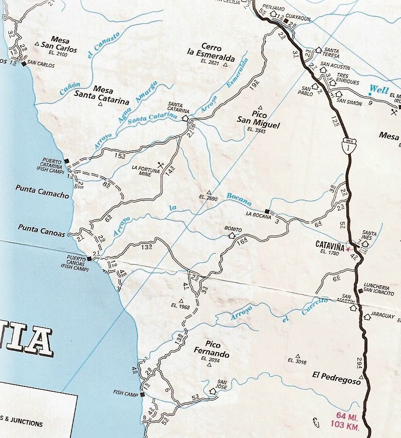
The 'Fish Camp' on the lower left of the map is San Jose (Faro San Jose is the lighthouse there)... There is also a Rancho San Jose up the arroyo from
the fish camp (on the map).
Per the posted directions given by Lizard Lips, the 4Runner was found near where the thin blue longitude line crosses the road to Puerto Canoas (with
the mileage 13.9 along side it).
|
|
|
willardguy
Elite Nomad
Posts: 6451
Registered: 9-19-2009
Member Is Offline
|
|
just out of curiosity......has anyone been able to spot the ranch in question on GE?
|
|
|
Mexitron
Ultra Nomad
Posts: 3397
Registered: 9-21-2003
Location: Fort Worth, Texas
Member Is Offline
Mood: Happy!
|
|
I haven't seen more than a couple wide spots in the road and what looks like cowboy camps in the area of the truck. There are more ranches on the
main road to San Jose however so its probably on of those.
|
|
|
EnsenadaDr
Banned
Posts: 5027
Registered: 9-12-2011
Location: Baja California
Member Is Offline
Mood: Move on. It is just a chapter in the past, but don't close the book- just turn the page
|
|
Thanks David, I am getting the layout in my mind. It matters because the route he took does not seem one that would have been logical to get to Punta
Canoas and since he was not an avid fisherman I doubt he was headed to the fish camp. It all just doesn't fit in because the main road that goes
through Santa Catarina would have been much more direct. Why did Gary take the road closer to Catavina to turn off the main highway instead? Or he
could have meandered over to Puerto Canoas from Punta Canoas where it seems there is some type of connection there,
|
|
|
mtgoat666
Select Nomad
Posts: 17383
Registered: 9-16-2006
Location: San Diego
Member Is Offline
Mood: Hot n spicy
|
|
| Quote: | Originally posted by EnsenadaDr
It all just doesn't fit in because the main road that goes through Santa Catarina would have been much more direct. Why did Gary take the road closer
to Catavina to turn off the main highway instead? |
perhaps he thought like this...
TWO roads diverged in a yellow wood,
And sorry I could not travel both
And be one traveler, long I stood
And looked down one as far as I could
To where it bent in the undergrowth;
Then took the other, as just as fair,
And having perhaps the better claim,
Because it was grassy and wanted wear;
Though as for that the passing there
Had worn them really about the same,
And both that morning equally lay
In leaves no step had trodden black.
Oh, I kept the first for another day!
Yet knowing how way leads on to way,
I doubted if I should ever come back.
I shall be telling this with a sigh
Somewhere ages and ages hence:
Two roads diverged in a wood, and I
I took the one less traveled by,
And that has made all the difference.
|
|
|
latina
Nomad
Posts: 210
Registered: 3-19-2011
Location: La Paz
Member Is Offline
|
|
You forgot to quote your source mtgoat 666.
Mexitron...I can't reread 84 pages....are you the person who quoted being on that road after Gary disappeared from his family?
Wasn't the road as far as the fork to Las Canoas the track for the Baja Mil in November?
|
|
|
Mexitron
Ultra Nomad
Posts: 3397
Registered: 9-21-2003
Location: Fort Worth, Texas
Member Is Offline
Mood: Happy!
|
|
latina---I've been out in that area a lot of the years but my friend Taco de Baja was the one out there last summer as the monsoon rains came in.
|
|
|
DENNIS
Platinum Nomad
Posts: 29510
Registered: 9-2-2006
Location: Punta Banda
Member Is Offline
|
|
| Quote: | Originally posted by latina
You forgot to quote your source mtgoat 666.
|
I'll do it for him: "Robert Frost"
"YOU CAN'T LITTER ALUMINUM"
|
|
|
wilderone
Ultra Nomad
Posts: 3781
Registered: 2-9-2004
Member Is Offline
|
|
"... since he was not an avid fisherman I doubt he was headed to the fish camp."
Doesn't matter if he wasn't planning on fishing. Getting to a "fish camp" means: (1) there's a road to it, i.e., access to the ocean/gulf; (2) there
would be a beach topography for launching a boat (or surfing or fishing or camping) - accessible oceanfront. He may have decided to go to the fish
camp to surf. The weather was poor, very likely had rained in that area between Sept. 5 and Sept. 9th. So did he try and then not make it all the
way - stopped short instead of driving in mud, or it was getting dark? Or did he get to the coast and was leaving because of bad weather? Or did he
take one of the many little spur roads and get lost? And started to hike back to the coast for assistance after he got stuck? Not necessarily on the
road? Do we believe the rancher that the car was not there in December?
|
|
|
danaeb
Senior Nomad
Posts: 991
Registered: 11-13-2006
Location: San Diego; El Centenario
Member Is Offline
Mood: groovy
|
|
| Quote: | Originally posted by woody with a view
|

Experience enables you to recognize a mistake every time you repeat it.
|
|
|
Taco de Baja
Super Nomad
Posts: 1913
Registered: 4-14-2004
Location: Behind the Orange Curtain, CA
Member Is Offline
Mood: Dreamin' of Baja
|
|
| Quote: | Originally posted by latina
Mexitron...I can't reread 84 pages....are you the person who quoted being on that road after Gary disappeared from his family?
|
I was out there the week before , August 25th, it was raining the first of several storms. I believe it was TW who was out there the week of, or week
after Gary was supposed to be there I was only on the road between San Jose and Catavina, and not the road to Canoas.
Truth generally lies in the coordination of antagonistic opinions
-Herbert Spencer
|
|
|
bajadogs
Super Nomad
Posts: 1058
Registered: 8-28-2006
Member Is Offline
|
|
| Quote: | Originally posted by willardguy
just out of curiosity......has anyone been able to spot the ranch in question on GE? |
I am very curious too, but I imagine the rancher would not want the whole cyber-nomad world zooming in on his humble ranch.
I would be very curious to see how easily or difficultly the rancher leads people to the spot. It could be very telling as to wether he may have
missed spotting the SUV in December. Of course the fact he went back to tow it out may blow my theory.
|
|
|
David K
Honored Nomad
Posts: 64523
Registered: 8-30-2002
Location: San Diego County
Member Is Offline
Mood: Have Baja Fever
|
|
| Quote: | Originally posted by EnsenadaDr
Thanks David, I am getting the layout in my mind. It matters because the route he took does not seem one that would have been logical to get to Punta
Canoas and since he was not an avid fisherman I doubt he was headed to the fish camp. It all just doesn't fit in because the main road that goes
through Santa Catarina would have been much more direct. Why did Gary take the road closer to Catavina to turn off the main highway instead? Or he
could have meandered over to Puerto Canoas from Punta Canoas where it seems there is some type of connection there, |
I thought I mentioned why he would not have likely used the Santa Catarina road to get to Canoas?: He does NOT have 4WD.
Not that 4WD is needed on the crossover road from Santa Catarina, but if he got advice, then the Faro San Jose road to Canoas may had been
recommended...? It is all graded and no moon dust pits... (as I had experienced on the north road into Canoas).
That he drove over a mile on a single track, off the graded road, then 400 meters up a wash to get stuck at, is weird.
|
|
|
bajadogs
Super Nomad
Posts: 1058
Registered: 8-28-2006
Member Is Offline
|
|
| Quote: | Originally posted by David K
That he drove over a mile on a single track, off the graded road, then 400 meters up a wash to get stuck at, is weird. |
Maybe weird, maybe just a mistake. How many times have you come across and rescued someone who drove a 2wd where they needed 4x4?
Plenty for me.
|
|
|
| Pages:
1
..
81
82
83
84
85
..
116 |


