| Pages:
1
..
21
22
23
24
25 |
DosMars
Nomad

Posts: 115
Registered: 12-11-2005
Member Is Offline
|
|
Quote: Originally posted by Troyeb  | | Hi Mark, me troye from San Felipe/Gonzaga - heard wonderful things about the canyon. I met the ultimate non-pervy guru of the Baja in a sweet man name
poncho at the mostincredible spear fishingand shore casting location possible. I caught 11 species there, 70 nmiles remote. You and theother mark
should getin touch for details. Nice to have met you. |
Hi Troye, other Mark here!
Great to have met you too. I'm guessing you got chased off the island by the wind? Sory we didn't have time to touch bases before you got back from
the water but I turned around and noticed our window was closing as the tide was rising. Sounds like you were able to break in your spear?
Good luck on the rest of your trip. Start a thread here and upload some pictures!
Mark's back at his car. He took a spill and punctured a couple of his water bottles on the way up to the ridge. He decided to head back out rather
than head in with less water than he felt comfortable with during the treck up and in.
|
|
|
Mark_BC
Nomad
Posts: 137
Registered: 12-1-2013
Location: Vancouver, BC
Member Is Offline
|
|
Hey everyone, ya I decided to turn back at the pass. I was being silly and trying to push my fully laden bike up a steep section and it fell on me and
I bashed up my knees. No structural damage but they were grazed and I didn't want to risk infection form the constant chaffing of riding a bike or
hiking. Plus I was poking holes in my water bottles. Previously I used my kayak paddles to protect them but I didn't bring the packraft this time and
didn't clue into this. I still had plenty of water but if I decided to go in, I'd have to desalinate at the ocean which might have been pushing it in
terms of having enough water to get back out.
So there is a nice motorbike trail up to the pass there. Apparently some American guys have ridden the entire route through to Bay of LA. I'd like to
try again with boat support and water drops on the beaches,m to avoid needing to desalinate. Also go with other people since it's a bit dicey by
myself. With the proper planning you could ride all the way from Calamajue to Bay of LA.
I'll post a trip report when I get organised.
Good to meet you Troy, I'll have to head down further some other time and check out the fishing.
|
|
|
David K
Honored Nomad
Posts: 64476
Registered: 8-30-2002
Location: San Diego County
Member Is Offline
Mood: Have Baja Fever
|
|
Glad you got out safe and decided to not make any risks we all would regret! I would like to know where this pass is.
The motorcycle track you mention sounds like a Bill Nichols track. TMW has posted Google Earth maps showing the Bill Nichols route.
Bill wanted to create routes across Baja that avoided paved roads (and major dirt roads, too). His first famous trail was across Baja from just south
of Puertecitos to Highway 1 (and on to the Pacific). Another is what you may have seen, across Baja to L.A. Bay (north of the paved road)?
|
|
|
David K
Honored Nomad
Posts: 64476
Registered: 8-30-2002
Location: San Diego County
Member Is Offline
Mood: Have Baja Fever
|
|
Long time since we heard from Mark...
|
|
|
ehall
Super Nomad
Posts: 1906
Registered: 3-29-2014
Location: Buckeye, Az
Member Is Offline
Mood: It's 5 o'clock somewhere
|
|
Wonder how those canyons are after the recent storms
|
|
|
David K
Honored Nomad
Posts: 64476
Registered: 8-30-2002
Location: San Diego County
Member Is Offline
Mood: Have Baja Fever
|
|
More palm trees washed out to the sea!
When my kids and I camped at Punta Candelero (that is where the road north over the two dry lake beds ends) the rock beach there was loaded with flash
flood palm debris that probably flushed out of La Asamblea/Salsipuedes system, which empties into the gulf just north of Candelero.
|
|
|
DosMars
Nomad
Posts: 115
Registered: 12-11-2005
Member Is Offline
|
|
Had to find this thread to link to on a biking thread on another forum.
When Covid dies down we're going to have to make another expedition to that canyon from the north route you scouted out!
|
|
|
RocketJSquirrel
Nomad
Posts: 251
Registered: 8-3-2019
Member Is Offline
|
|
OP realizes, I hope, that Salsipuedes means "Leave if you can". Not an inviting name for an area...
Is that not right?
|
|
|
rich t
Nomad
Posts: 102
Registered: 4-18-2016
Member Is Offline
|
|
There is a new bike trail that makes it more accessible, it runs from BOLA to Gonzaga Bay, it is a single track called the palm trail.
|
|
|
David K
Honored Nomad
Posts: 64476
Registered: 8-30-2002
Location: San Diego County
Member Is Offline
Mood: Have Baja Fever
|
|
Yes, or "Get out, if you can" as Erle Stanley Gardner said in his 1961 adventure book, 'Hovering Over Baja' where Gardner said, to him, it meant 'Get
In if you can'.
|
|
|
David K
Honored Nomad
Posts: 64476
Registered: 8-30-2002
Location: San Diego County
Member Is Offline
Mood: Have Baja Fever
|
|
| Quote: Originally posted by rich t | | There is a new bike trail that makes it more accessible, it runs from BOLA to Gonzaga Bay, it is a single track called the palm trail.
|
Can you provide a map, link, or description of the route, since this is a region of cliffs and canyons unless it goes around, as the El Camino Real
and auto roads do? Thanks!
|
|
|
rich t
Nomad
Posts: 102
Registered: 4-18-2016
Member Is Offline
|
|
I normally have no problem posting a track, but the person that gave it to me did so with the understanding that I would not share it, There is a
common point that will let you find it, if you leave BOLA heading north and go as far as you can in Laguna Seca, and look to the north on the side of
the mountain you will see a single track, from that track you can take a right turn to Salsepedes.
|
|
|
larryC
Super Nomad
Posts: 1482
Registered: 8-11-2008
Location: BoLA
Member Is Offline
|
|
The one time I ran across the bike trail it was at the northern end of the northern dry lake and unfortunately the bike trail was using the old Camino
Real. The same trail ESG used to get his Pack Jacks into Asamblea. A shame to see the old historic trail being obliterated but stuff happens.
Off grid, 12-190 watt evergreen solar panels on solar trackers, 2-3648 stacked Outback inverters, 610ah LiFePo4 48v battery bank, FM 60 and MX60
Outback charge controllers, X-240 Outback transformer for 240v from inverters, 6500 watt Kubota diesel generator.
|
|
|
David K
Honored Nomad
Posts: 64476
Registered: 8-30-2002
Location: San Diego County
Member Is Offline
Mood: Have Baja Fever
|
|
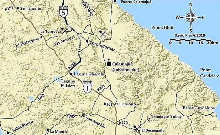
While it is true that motorcycles are using some of El Camino Real from where it crosses the L.A. Bay highway to the area of Tinaja de Yubay, there is
no part of the Jesuit road north of the dry lakes. See also www.caminorealbaja.com using Google Earth.
On a map that geoffff and I are working on (under construction here):
is the Camino Real from San Borja (bottom push pin) to Calamajué (top push pin). Map also shows Hwy. 1 and in lighter detail the L.A, Bay highway and
the bigger lakebed:

|
|
|
RocketJSquirrel
Nomad
Posts: 251
Registered: 8-3-2019
Member Is Offline
|
|
Love the map with Coco's corner. Took that turn off by accident from the new 5 (about two years ago) - turned around after a bit as were were in a VW
Jetta and thought we might run out of petrol and die out there. If I had that map, would have continued to Coco's!
|
|
|
RocketJSquirrel
Nomad
Posts: 251
Registered: 8-3-2019
Member Is Offline
|
|
Needless to say, you should research your drive carefully. Or not!
|
|
|
rich t
Nomad
Posts: 102
Registered: 4-18-2016
Member Is Offline
|
|
The track I refered to is not part of the old Camino, it actually runs up the coast from BOLA and heads west below Condelero beach, into Laguna Seca,
you can get to Laguna Seco in a 4 x 4, that is the end of your Jeep trail, from there if you look around to the north you can figure out how to get
get on the single track which is a fairly new Bill Nichols trail, it is about 2 years old.
|
|
|
TMW
Select Nomad
Posts: 10659
Registered: 9-1-2003
Location: Bakersfield, CA
Member Is Offline
|
|
Rich are you talking about the Window Rock Trail?
|
|
|
larryC
Super Nomad
Posts: 1482
Registered: 8-11-2008
Location: BoLA
Member Is Offline
|
|
| Quote: Originally posted by David K | While it is true that motorcycles are using some of El Camino Real from where it crosses the L.A. Bay highway to the area of Tinaja de Yubay, there is
no part of the Jesuit road north of the dry lakes. See also www.caminorealbaja.com using Google Earth.
On a map that geoffff and I are working on (under construction here):
is the Camino Real from San Borja (bottom push pin) to Calamajué (top push pin). Map also shows Hwy. 1 and in lighter detail the L.A, Bay highway and
the bigger lakebed:
|
The trail that I am referring to is what I assume ESG was referring to when talked, in his book "Hovering over Baja" about going out through the dry
lake bed and finding a trail up and over a hill that they used for the Pak-Jaks and then dropped down into Botica wash and lowered the P/J,s down a
cliff. I doubt the trail he found was made by bikers. If that trail isn't the old camino real then it is another trail to somewhere. Someone moved a
lot of rocks to make a smooth foot path. Maybe a side path to access the water in Asamblea.
Off grid, 12-190 watt evergreen solar panels on solar trackers, 2-3648 stacked Outback inverters, 610ah LiFePo4 48v battery bank, FM 60 and MX60
Outback charge controllers, X-240 Outback transformer for 240v from inverters, 6500 watt Kubota diesel generator.
|
|
|
David K
Honored Nomad
Posts: 64476
Registered: 8-30-2002
Location: San Diego County
Member Is Offline
Mood: Have Baja Fever
|
|
Got it... I suspect Erle used ECR photos and used them to enhance his story (authors do that)??
|
|
|
| Pages:
1
..
21
22
23
24
25 |


