| Pages:
1
..
22
23
24
25 |
matthew_mangus
Junior Nomad

Posts: 81
Registered: 10-4-2019
Location: Portland, OR
Member Is Offline
|
|
Quote: Originally posted by David K  |
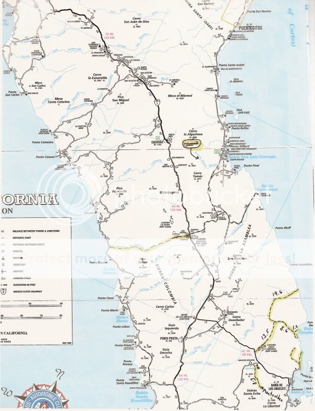
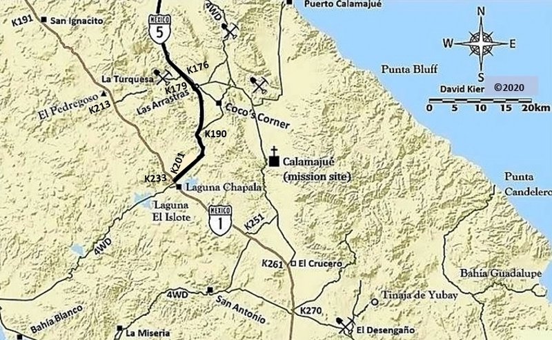
On a map that geoffff and I are working on (under construction here):
is the Camino Real from San Borja (bottom push pin) to Calamajué (top push pin). Map also shows Hwy. 1 and in lighter detail the L.A, Bay highway and
the bigger lakebed:
|
David, What condition is that route? I'll be down there in Feb and was planning on taking the Calumujue Wash route from Coco's and then trying to stay
on a bit of the Window Rock trail before dumping out to the pavement on the way into the Bay of LA. I'd be interested in checking out a new route if
you don't mind sharing.
I like to explore remote dirt tracks and beaches.
|
|
|
rich t
Nomad
Posts: 102
Registered: 4-18-2016
Member Is Offline
|
|
TMW, No this is not the Window Rock Trail, I have done the Window Rock many times, it run west/east, if you were in the dry lake bed out of BOLA
heading north and got to the junction that would be a left turn to the Window Rock Trail, don't turn, continue going north, that will take you into
another wash called Laguna Seca, it is a 2 track, go as far as you can go and you will see the single track. There are many trails that share that
junction heading to the Window Rock.
|
|
|
larryC
Super Nomad
Posts: 1482
Registered: 8-11-2008
Location: BoLA
Member Is Offline
|
|
Rich
You say to go the second dry lake, and go as far as you can go. I have gone to the second dry lake several times and as I remember when you get to the
second dry lake the road Y's and if you go to the right you end up at the ocean. If you go left you end up at what I call ESG's old camp site and that
is where the single track picks up on what I called the El Camino Real going up the rocky hill and over down to the desert. Is that how you remember
it?
Off grid, 12-190 watt evergreen solar panels on solar trackers, 2-3648 stacked Outback inverters, 610ah LiFePo4 48v battery bank, FM 60 and MX60
Outback charge controllers, X-240 Outback transformer for 240v from inverters, 6500 watt Kubota diesel generator.
|
|
|
David K
Honored Nomad
Posts: 64479
Registered: 8-30-2002
Location: San Diego County
Member Is Offline
Mood: Have Baja Fever
|
|
| Quote: Originally posted by matthew_mangus | | Quote: Originally posted by David K |
On a map that geoffff and I are working on (under construction here):
is the Camino Real from San Borja (bottom push pin) to Calamajué (top push pin). Map also shows Hwy. 1 and in lighter detail the L.A, Bay highway and
the bigger lakebed:
|
David, What condition is that route? I'll be down there in Feb and was planning on taking the Calamajué Wash route from Coco's and then trying to
stay on a bit of the Window Rock trail before dumping out to the pavement on the way into the Bay of LA. I'd be interested in checking out a new route
if you don't mind sharing. |
The auto road from Calamajué Mission/ Mill south to Hwy. 1 (Km. 251 or Km. 261 (El Crucero) is easy the last two times I drove it (2012 &
2016)... just a lot of whoops north of El Crucero. The water was not deep both those trips (both in the summer).
Some photos along that way:
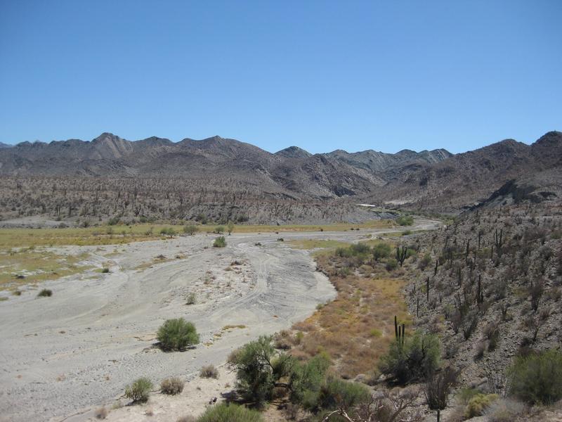
View of Calamajué from the gold ore mill.
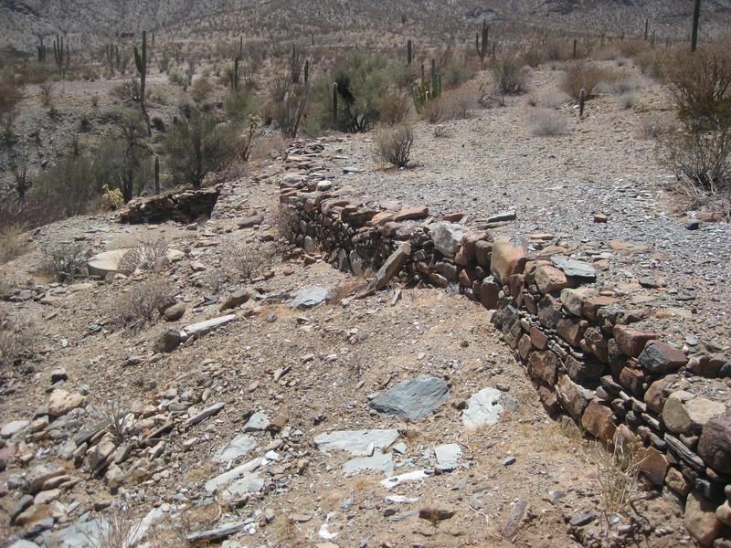
Mill ruins
Dropping to the arroyo. At the bottom, look for a track to the left and across, to go see the mission site
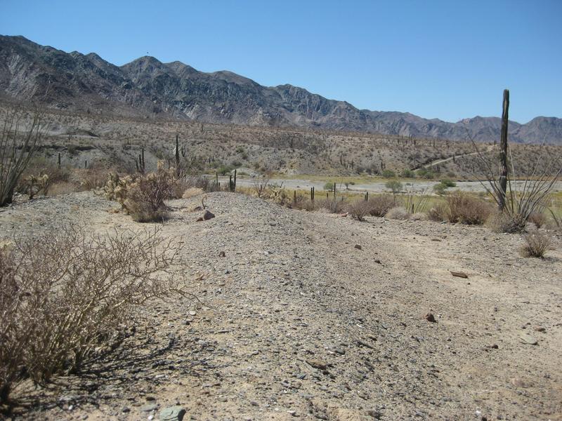
1766 Mission church outline (across the arroyo from the mill). See the road dropping to the arroyo, across the way?
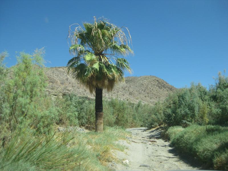
A few palms in the canyon.
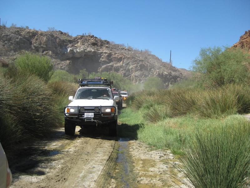
Road in the canyon (sometimes has a few more inches of water, watch for holes)
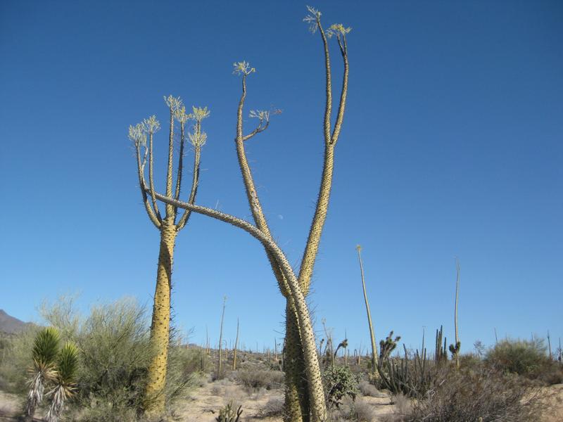
Dancing boojums are passed before El Crucero.
|
|
|
rich t
Nomad
Posts: 102
Registered: 4-18-2016
Member Is Offline
|
|
Larry C, I have all my Baja almanacs in Baja so I can't reference Lat/long for you, if you look in the almanac you will see a spot called Laguna Seca,
there is a Y before you enter it, the east leg goes to Condelero beach thru the canyon, if you go to the north end of Laguna Seca it dead ends at a
mountain range, Bill Nichols cut a single track up the rocky hill, it is a rough trail, it parallels the coast then opens up toward Calamujue fish
camp, it is east of Calamuje wash, then the trail continues north and uses the Pioneer Mine trail to get to Gonzaga.
|
|
|
David K
Honored Nomad
Posts: 64479
Registered: 8-30-2002
Location: San Diego County
Member Is Offline
Mood: Have Baja Fever
|
|
| Quote: Originally posted by rich t | | Larry C, I have all my Baja almanacs in Baja so I can't reference Lat/long for you, if you look in the almanac you will see a spot called Laguna Seca,
there is a Y before you enter it, the east leg goes to Condelero beach thru the canyon, if you go to the north end of Laguna Seca it dead ends at a
mountain range, Bill Nichols cut a single track up the rocky hill, it is a rough trail, it parallels the coast then opens up toward Calamujue fish
camp, it is east of Calamuje wash, then the trail continues north and uses the Pioneer Mine trail to get to Gonzaga. |
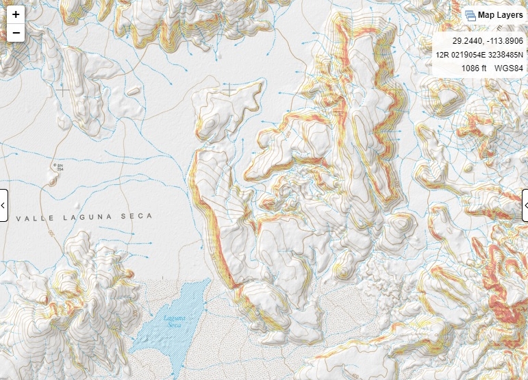
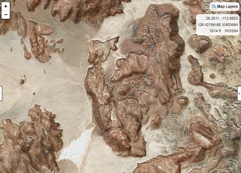
When I drove to Laguna Seca and on to 'Candelero Beach', the road stayed along the east side of the lake, parallel to the big mesa (on the east side
of the lake... at the north end of the lake and the end of the mesa, the road turned to the east and went into the colorful Los Candeleros Canyon to
the coast.
The 19.6 mile section I added to the AAA map...
I didn't note any fork, but I was focused on getting to the coast that trip and it was a long time ago (2002). I do show it on my maps... to Punta
Candelero:
|
|
|
rich t
Nomad
Posts: 102
Registered: 4-18-2016
Member Is Offline
|
|
David, it is more of an intersection than a fork, that is pretty wide open before you head into Laguna Seca, was just trying to give a reference
point, we were in there earlier in the year, March if I remember correctly. If you go in there and look to the North on the barren rocky hill you will
see the trail, it has not been run by a lot of bikes.
|
|
|
David K
Honored Nomad
Posts: 64479
Registered: 8-30-2002
Location: San Diego County
Member Is Offline
Mood: Have Baja Fever
|
|
Cool!
Well, if you ever want to see it from space and record the GPS for it, Google Earth is your friend! There is also the CalTopo map system from Nomad
geoffff that can flip maps and satellite images back and forth.
https://caltopo.com/map.html
Laguna Seca to north of mesa:
[Edited on 12-15-2020 by David K]
|
|
|
rich t
Nomad
Posts: 102
Registered: 4-18-2016
Member Is Offline
|
|
I looked up the track, the junction at Condelero and Laguna Seco is N29.14.664' w113.51.289', go into Laguna Seca to N29.18.012 W113.54.084' this is
where the single track starts, there is a short spur that goes a couple of hundred yards to the left, then it deadends. The junction that takes you to
Salsepuedes(spelling) beach is N 29.25.333' W113.55.648'
it is about 6 1/2 miles to the beach from the last junction.
|
|
|
TMW
Select Nomad
Posts: 10659
Registered: 9-1-2003
Location: Bakersfield, CA
Member Is Offline
|
|
| Quote: Originally posted by rich t | | TMW, No this is not the Window Rock Trail, I have done the Window Rock many times, it run west/east, if you were in the dry lake bed out of BOLA
heading north and got to the junction that would be a left turn to the Window Rock Trail, don't turn, continue going north, that will take you into
another wash called Laguna Seca, it is a 2 track, go as far as you can go and you will see the single track. There are many trails that share that
junction heading to the Window Rock. |
Thanks
|
|
|
David K
Honored Nomad
Posts: 64479
Registered: 8-30-2002
Location: San Diego County
Member Is Offline
Mood: Have Baja Fever
|
|
| Quote: Originally posted by rich t | I looked up the track, the junction at Condelero and Laguna Seco is N29.14.664' w113.51.289', go into Laguna Seca to N29.18.012 W113.54.084' this is
where the single track starts, there is a short spur that goes a couple of hundred yards to the left, then it deadends. The junction that takes you to
Salsepuedes(spelling) beach is N 29.25.333' W113.55.648'
it is about 6 1/2 miles to the beach from the last junction. |
With help from geoffff, we converted your waypoints to ones that work on CalTopo or other imaging systems, just add a space instead of the degree °
symbol or the period you had . :
N29 14.664' W113 51.289'
N29 18.012' W113 54.084'
N29 25.333' W113 55.648'
I see the trail west of the lakebed and climbing the hill! Cool. Is the final one the junction of Salsipuedes with La Asamblea?
|
|
|
rich t
Nomad
Posts: 102
Registered: 4-18-2016
Member Is Offline
|
|
David, I could not find a degree key on my key board, I knew you would figure it out(LOL)
|
|
|
rich t
Nomad
Posts: 102
Registered: 4-18-2016
Member Is Offline
|
|
The final one is the junction on Bill Nichols trail where you turn east to the coast, the bike trail continues North.
|
|
|
David K
Honored Nomad
Posts: 64479
Registered: 8-30-2002
Location: San Diego County
Member Is Offline
Mood: Have Baja Fever
|
|
Hold down the Alt key and press 2 4 8 (to get °)
[Edited on 12-16-2020 by David K]
|
|
|
TMW
Select Nomad
Posts: 10659
Registered: 9-1-2003
Location: Bakersfield, CA
Member Is Offline
|
|
That don't work for me.
|
|
|
rich t
Nomad
Posts: 102
Registered: 4-18-2016
Member Is Offline
|
|
Did not work for me either.
|
|
|
David K
Honored Nomad
Posts: 64479
Registered: 8-30-2002
Location: San Diego County
Member Is Offline
Mood: Have Baja Fever
|
|
Windows 10
Alt + 248
There is another code, too.
|
|
|
Mark_BC
Nomad
Posts: 137
Registered: 12-1-2013
Location: Vancouver, BC
Member Is Offline
|
|
| Quote: Originally posted by David K | | Quote: Originally posted by rich t | I looked up the track, the junction at Condelero and Laguna Seco is N29.14.664' w113.51.289', go into Laguna Seca to N29.18.012 W113.54.084' this is
where the single track starts, there is a short spur that goes a couple of hundred yards to the left, then it deadends. The junction that takes you to
Salsepuedes(spelling) beach is N 29.25.333' W113.55.648'
it is about 6 1/2 miles to the beach from the last junction. |
With help from geoffff, we converted your waypoints to ones that work on CalTopo or other imaging systems, just add a space instead of the degree °
symbol or the period you had . :
N29 18.012' W113 54.084'
I see the trail west of the lakebed and climbing the hill! Cool. Is the final one the junction of Salsipuedes with La Asamblea?
|
That's how I got in, more or less. On Google Earth you can see the trail going up the hill and into Botica. I went up the left hand side of that
little gully not realizing the trail was on the right. I'm not sure how he got into Salsipuedes from Botica though. I got in by turning due left
midway down the Botica lakebed and went in over a little hill into the wash to the west, then don Salsipuedes.
A couple years ago I tried to get in from the north from the Calamajue wash. I found the motorbike trail in and crested it to the top before it
descends. So the trail goes all the way through. But I fell and scraped up my knee, and wasn't really into it so I turned back. Maybe I'll try again,
it would be better to stash water on the beaches beforehand so you don't have to waste time desalinating.
|
|
|
David K
Honored Nomad
Posts: 64479
Registered: 8-30-2002
Location: San Diego County
Member Is Offline
Mood: Have Baja Fever
|
|
Yes.
Another code is Alt + 167 º
More codes for Nomads:
https://www.spanishnewyork.com/spanish-characters.html
[Edited on 12-16-2020 by David K]
|
|
|
David K
Honored Nomad
Posts: 64479
Registered: 8-30-2002
Location: San Diego County
Member Is Offline
Mood: Have Baja Fever
|
|
Hi Mark! Good to see you on Nomad... I sure hope the borders open up so you guys can get to warmer climates and explore more Baja!
|
|
|
| Pages:
1
..
22
23
24
25 |


