| Pages:
1
2
3
4
..
25 |
motoged
Elite Nomad

Posts: 6481
Registered: 7-31-2006
Location: Kamloops, BC
Member Is Offline
Mood: Gettin' Better
|
|
I am still waiting to see someone ride it in soft sand guys....downhill for 50 feet doesn't do it....
I like the concept and get it that it's a fun bike, but all the vids are on wet sand (the San Juanico sand chute and rocks aside).
No disrespect....just doubt about the sand wash travel unless hardpacked.... 
Don't believe everything you think....
|
|
|
elgatoloco
Ultra Nomad
Posts: 4323
Registered: 11-19-2002
Location: Yes
Member Is Offline
|
|
Perfect Baja bike. Good times.
MAGA
Making Attorneys Get Attorneys
|
|
|
Skipjack Joe
Elite Nomad
Posts: 8084
Registered: 7-12-2004
Location: Bahia Asuncion
Member Is Offline
|
|
| Quote: | Originally posted by Mark_BC
Then the plan is to packraft / ride the beach back down the coast to La Gringa, catching fish as I go. If the winds are really bad I can go up some
other washes instead and ride back through the dry lakes north of Bay of LA.
|
Yes, you better just ride through the dry lake beds because there is very little opportunity to ride along the coast. The few beaches are far between.
The packraft doesn't seem to be very seaworthy to me. You should think over the idea of paddling a raft along that section of the coastline in my
opinion.
|
|
|
woody with a view
PITA Nomad
Posts: 15937
Registered: 11-8-2004
Location: Looking at the Coronado Islands
Member Is Offline
Mood: Everchangin'
|
|
what happens to the bike when you are rafting? does it lay on the raft? is there a foto of ytour raft/trailer/bike somewhere that i missed?
|
|
|
larryC
Super Nomad
Posts: 1482
Registered: 8-11-2008
Location: BoLA
Member Is Offline
|
|
| Quote: | Originally posted by Mark_BC
That's an interesting setup dagona. Interestingly I am at a steam conference today.
Regarding the safety of the trip, the main concerns are if I get a flat. But I will inject stan's goop into the tubes. Most of the ride is sandy wash
with no cactus. Sand is no problem to ride over with a fatbike. Also, the tricky areas will be on days 2 and 3 at the head of the canyon do easy to
backtrack out if there's a problem. And once in the canyon, the worst ill have to do is hike 20 km out to the ocean, no big deal.
If I get attacked by coyotes or bitten by a snake, well I'll have to deal with it. That's what the spot is for. Yesterday i practiced hauling 20 l on
my trailer, you barely even feel it. |
Not sure what you are envisioning up at the top of the canyons, but you can expect to be lifting and lowering your bike and trailer up and over 20'
and 40' rocks and down some 40'+ cliffs before you get to the sandy wash part. Some of the canyon is easy going and some is not. I ran my quad into
some quick sand and if I had been alone I would have lost it. We just had an all day rain here about 2 weeks ago so you will probably find some water
up there.
Salsipuedes and Asamblea canyons start up there. Asamblea starts at the end of the road. The road actually goes a kilometer or 2 down into the canyon.
At the end of the road is where all the huge granite rocks are, similar in appearance to the rocks around Catavina. Salsipuedes starts before the end
of the road and is not marked, at least wasn't when I was last up there. Salsipuedes is the more interesting of the 2 canyons. You are going to have a
real adventure, wish I was going to be around to help.
Larry
Off grid, 12-190 watt evergreen solar panels on solar trackers, 2-3648 stacked Outback inverters, 610ah LiFePo4 48v battery bank, FM 60 and MX60
Outback charge controllers, X-240 Outback transformer for 240v from inverters, 6500 watt Kubota diesel generator.
|
|
|
David K
Honored Nomad
Posts: 64480
Registered: 8-30-2002
Location: San Diego County
Member Is Offline
Mood: Have Baja Fever
|
|
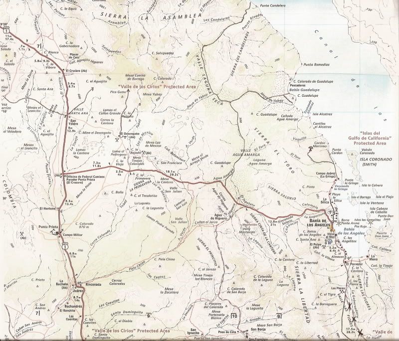
Use Google Earth to study the coastline... Except for Guadalupe Bay, not any beach north of La Gringa to Arroyo La Asamblea. You can drive/ride from
Arroyo Los Candeleros to Laguna Seca and Laguna Agua Amarga out to the L.A. Bay highway.
|
|
|
larryC
Super Nomad
Posts: 1482
Registered: 8-11-2008
Location: BoLA
Member Is Offline
|
|
About 3 miles south of the entrance to the canyons there is one small sandy beach where you could make landfall. There is/was also a small shack used
seasonally by commercial fishermen on the beach. From there to Candeleros the coast is pretty rugged. He is going to have to be pretty careful while
in the raft along the rugged parts of the coast, cause if the wind comes up it could get tricky. We get some pretty serious north winds that time of
year.
Larry
Off grid, 12-190 watt evergreen solar panels on solar trackers, 2-3648 stacked Outback inverters, 610ah LiFePo4 48v battery bank, FM 60 and MX60
Outback charge controllers, X-240 Outback transformer for 240v from inverters, 6500 watt Kubota diesel generator.
|
|
|
Santiago
Ultra Nomad
Posts: 3499
Registered: 8-27-2003
Member Is Offline
|
|
Since you have a Spot, arrange with someone to come pick you up by boat?
|
|
|
Barry A.
Select Nomad
Posts: 10007
Registered: 11-30-2003
Location: Redding, Northern CA
Member Is Offline
Mood: optimistic
|
|
| Quote: | Originally posted by Santiago
Since you have a Spot, arrange with someone to come pick you up by boat? |
----or, as an alternative, there is a reported fairly good dirt veh. track (not on Baja Atlas maps) that comes from the west (NE end of Valle Laguna
Seca) down Los Candeleros wash to the Gulf about 1 mile north of Punta Candelero, as I understand it. This wash/road is about 10 miles south of the
mouth of Asamblea/Salsipuedes wash. I don't know if this "10 miles" is hike-able, tho (cliffs?) and this area is very mountainous.
I have never personally seen this "reported" road.
Barry
[Edited on 12-3-2013 by Barry A.]
[Edited on 12-3-2013 by Barry A.]
|
|
|
David K
Honored Nomad
Posts: 64480
Registered: 8-30-2002
Location: San Diego County
Member Is Offline
Mood: Have Baja Fever
|
|
Barry, I drew the roads onto the Almanac map (just a couple posts up) from my personal experience driving on it about 10 years ago. The drive to both
Candeleros and Guadalupe Bay was all done in 2WD (Tacoma) with ease... but it was winter and the arroyo sand may have been damper than usual.
The mileage from the L.A. Bay highway to the T junction (Arroyo Mesa de Yubay) is 13.5
T Junction to Bahia Guadalupe is 9.8 miles.
T Junction to Punta Candelero is 19.6 miles.
|
|
|
Barry A.
Select Nomad
Posts: 10007
Registered: 11-30-2003
Location: Redding, Northern CA
Member Is Offline
Mood: optimistic
|
|
| Quote: | Originally posted by David K
Barry, I drew the roads onto the Almanac map (just a couple posts up) from my personal experience driving on it about 10 years ago. The drive to both
Candeleros and Guadalupe Bay was all done in 2WD (Tacoma) with ease... but it was winter and the arroyo sand may have been damper than usual.
The mileage from the L.A. Bay highway to the T junction (Arroyo Mesa de Yubay) is 13.5
T Junction to Bahia Guadalupe is 9.8 miles.
T Junction to Punta Candelero is 19.6 miles. |
Ooops, I now see that, David. Sorry for the duplication, and knee-jerk post.
Barry
|
|
|
Mark_BC
Nomad
Posts: 137
Registered: 12-1-2013
Location: Vancouver, BC
Member Is Offline
|
|
| Quote: | Originally posted by larryC
Not sure what you are envisioning up at the top of the canyons, but you can expect to be lifting and lowering your bike and trailer up and over 20'
and 40' rocks and down some 40'+ cliffs before you get to the sandy wash part. Some of the canyon is easy going and some is not. I ran my quad into
some quick sand and if I had been alone I would have lost it. We just had an all day rain here about 2 weeks ago so you will probably find some water
up there.
Salsipuedes and Asamblea canyons start up there. Asamblea starts at the end of the road. The road actually goes a kilometer or 2 down into the canyon.
At the end of the road is where all the huge granite rocks are, similar in appearance to the rocks around Catavina. Salsipuedes starts before the end
of the road and is not marked, at least wasn't when I was last up there. Salsipuedes is the more interesting of the 2 canyons. You are going to have a
real adventure, wish I was going to be around to help.
Larry |
That's my biggest concern, having to contend with the big rocks. At least that will only be a couple days in and not far from the road. I'll bring
rope.
Now I have to worry about quicksand too! Never experienced it myself except watching on Gilligan's Island. There is a lot of flotation with these
tires and the bike isn't heavy so I should be able to haul it out if it gets stuck. Regarding concerns about riding in loose sand, the bike really can
handle it fine, not an issue, it's surprising how easy it is. The trailer might be a bit of a problem though since it won't accept a big fat tire.
I'll put the fattest one I can in there and experiment with it next weekend. If there's water that will help because then I won't have to haul as much
in the trailer, and lighten its load.
Someone earlier wondered about the stability of the packraft -- yes, it's very stable. I have actually done whitewater rivers in it (that's what it's
made for, among other things like hauling a moose out of the bush), with my bike strapped to the front! And most of my gear can go inside the tubes. I
don't know if I posted a link before, but here it is:
https://www.alpackaraft.com/index.cfm/store.catalog/Packraft...
True American innovation!
But if I get stuck in those strong winds out on the water that could be a problem. I've experienced them before.
|
|
|
Skipjack Joe
Elite Nomad
Posts: 8084
Registered: 7-12-2004
Location: Bahia Asuncion
Member Is Offline
|
|
| Quote: | Originally posted by Mark_BC
Someone earlier wondered about the stability of the packraft -- yes, it's very stable. I have actually done whitewater rivers in it (that's what it's
made for, among other things like hauling a moose out of the bush), with my bike strapped to the front! And most of my gear can go inside the tubes. I
don't know if I posted a link before, but here it is:
https://www.alpackaraft.com/index.cfm/store.catalog/Packraft...
True American innovation!
But if I get stuck in those strong winds out on the water that could be a problem. I've experienced them before. |
Yes, that's the concern. Any wind will blow you around like a sail. Even rowing on a calm day will be a major chore because it's not hydrodynamic.
I still think you should work your way south inland, following the low flat areas as much as is available. In looking at google earth it seems that
there is a fairly small relatively easy climb from the head of the canyon to an arm leading into the dry lake south of it. Once you reach that lake
you can proceed back to the coast near Pt Remedios and have a section of sandy beach south of there.
If you plan to fish for food concentrate on the rocky points. Don't bother with the sandy beaches. We used large rapalas and swimbaits for leopard
grouper from shore. They're in the suds by the rocks. Find a rockpile that's protruding from 4 feet of water and about 30 feet from shore. Work the
lures around it's edges. Don't be enticed by those deep rocks you will see from the ledges. This we learned from experience.
If you have bait you can just chuck and wait. And probably catch more and a greater variety of fish.
Bring tire repair equipment. There is a cactus (I believe it's chainlink cactus) that breaks off it's tips and lay on the ground next to it. Some grow
right next to the dirt road and these 'links' often end up on the road itself. They are really difficult to see. I had to use needlenose pliers to
remove them from the tire because of the barbs on each spine.
|
|
|
larryC
Super Nomad
Posts: 1482
Registered: 8-11-2008
Location: BoLA
Member Is Offline
|
|
Mark
I didn't mean to imply that you won't be able to make it because of quicksand, I just mentioned it because water is so rare to find down here. I think
I posted a picture of the sunken quad in my original thread.
Larry
Joe
If you are talking about the Botica wash, that is where ESG had to lower his packjacks down a cliff. I climbed that cliff and walked up toward the dry
lake but ran out of daylight and had to turn back before I got to the top. Once over the cliff then it was easy going up the wide flat wash. According
to ESG in Hoovering over Baja, once you get to the top at the dry lake then you still have a pretty rough hill or 2 to get over before you drop down
into the dry lake that is part of Candeleros wash.
If this place was easy to get into then there would be a resort in there.
Larry
Off grid, 12-190 watt evergreen solar panels on solar trackers, 2-3648 stacked Outback inverters, 610ah LiFePo4 48v battery bank, FM 60 and MX60
Outback charge controllers, X-240 Outback transformer for 240v from inverters, 6500 watt Kubota diesel generator.
|
|
|
Skipjack Joe
Elite Nomad
Posts: 8084
Registered: 7-12-2004
Location: Bahia Asuncion
Member Is Offline
|
|
N 29 16'40.99 W 113 56'08.32
Marks a spot that connects the 2 level areas with the least amount of rock climbing. Follow the main canyon southwest until the side canyon and then
turn east until you reach the marker. Then rough it south along that gully for maybe 2 miles to the side canyon going east and leading to the dry
lake. The marker is the only difficult part and appears to be the least rugged gap from the canyons to the lake bed.
Enter those coordinates on google earth and it will zoom you to the proposed area.
Suerte
[Edited on 12-4-2013 by Skipjack Joe]
|
|
|
larryC
Super Nomad
Posts: 1482
Registered: 8-11-2008
Location: BoLA
Member Is Offline
|
|
Joe
I don't know if you have been out there but I have and that is some very rugged country. I won't say it can't be done but I will say that it can't be
done the way I need to do it. On a quad or something like that. After looking at Google earth again and looking at the way Gardener went in, it looks
like once he got onto the Botica dry lake he could have turned in a westerly direction and picked up a finger of salsipuedes and followed it into the
canyon instead of going down the Botica wash and having to lower his Packjacks over the cliff. If only he would have Google earth to consult. Actually
that is exactly what my friends did when they went in in 2010, they were able to ride up the canyon all the way to Botica dry lake, but still no one
has found an easy way to get over the rocks and onto the dry lake that is accessible by truck from Bahia. If anyone wants to look some more from
ground level let me know I'd like to join the expedition.
Larry
Larry
Larry
Off grid, 12-190 watt evergreen solar panels on solar trackers, 2-3648 stacked Outback inverters, 610ah LiFePo4 48v battery bank, FM 60 and MX60
Outback charge controllers, X-240 Outback transformer for 240v from inverters, 6500 watt Kubota diesel generator.
|
|
|
David K
Honored Nomad
Posts: 64480
Registered: 8-30-2002
Location: San Diego County
Member Is Offline
Mood: Have Baja Fever
|
|
| Quote: | Originally posted by Skipjack Joe
N 29 16'40.99 W 113 56'08.32
Marks a spot that connects the 2 level areas with the least amount of rock climbing. Follow the main canyon southwest until the side canyon and then
turn east until you reach the marker. Then rough it south along that gully for maybe 2 miles to the side canyon going east and leading to the dry
lake. The marker is the only difficult part and appears to be the least rugged gap from the canyons to the lake bed.
Enter those coordinates on google earth and it will zoom you to the proposed area.
Suerte
[Edited on 12-4-2013 by Skipjack Joe] |
Here is Igor's waypoint on GE... all three zooms are with north at the top, the closest view at an angle. It is west from the second dry lake (Laguna
Seca):
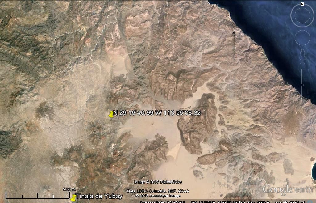
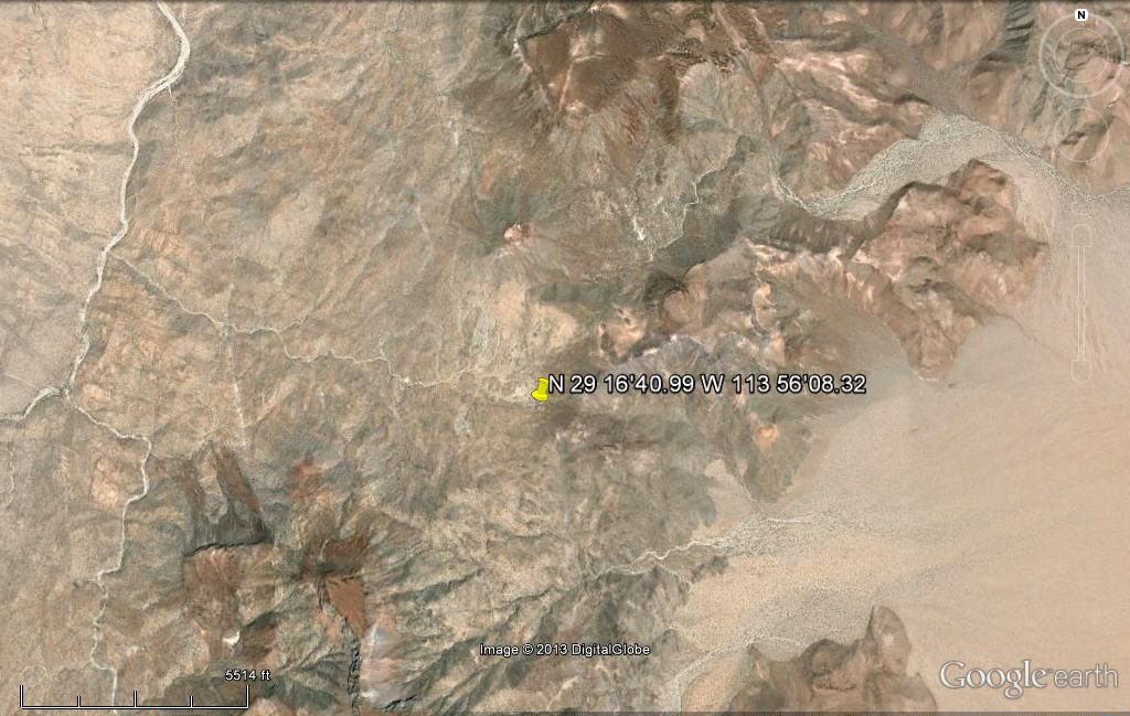
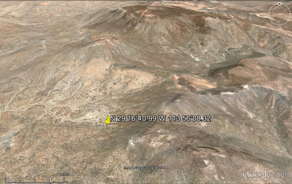
|
|
|
Mark_BC
Nomad
Posts: 137
Registered: 12-1-2013
Location: Vancouver, BC
Member Is Offline
|
|
Yeah I looked into that route but it looks like there's a lot of scrub and likely cactus I'd have to pull my bike over. And I'd have to get way up the
dry lakes too, whereas the other approach is from the highway. But it might be an option. We actually went up there last June to check it out and I
took some pictures and video of the hills as seen from the road beside that steep sloped flat mesa before it turns east to go down to Condelero. Those
hills look a lot more intimidating in person than in Google Earth! But the good part is that there is no cactus in the dry lake leading up to that
traverse and would be very easy to ride across.
|
|
|
Skipjack Joe
Elite Nomad
Posts: 8084
Registered: 7-12-2004
Location: Bahia Asuncion
Member Is Offline
|
|
This was a suggestion of how to get from Salsipuedes canyon south to BOLA without walking the coast or going back to the highway.
I think you have the advantage of picking up your bike and carrying it over the rough stuff, something the quad people can't do.
There may be an issue of water as well. As I understand it you can make water from the sea but it has to be carried everywhere else. I figure it would
take 3 days to go from the mouth of salsipuedes to guadalupe bay. 1st day to work your way up the canyon from the sea to it's source. 2nd day to cross
the saddle to the dry lake. 3rd day to cross 2 dry lakes to the bay.
The side canyon leading to the marker has a couple of areas that are blocked with huge boulders. You may need ropes to haul your bikes up those
things. You will probably have to walk your bikes leading up to the marker and have to carry them down that slope, but after that it's smooth sailing.
Some of those lakes are as smooth as a billiard table, as you know.
Thanks for posting those images David. If you lower your view even further you get a good 3 dimensional view of the entire trail. In the last image
the best way seemed to be straight down the picture, not the direction we are looking at to the right.
Wish I was going. Stay safe. Go light but go right. Bring a lot of Cliff Bars. 
|
|
|
motoged
Elite Nomad
Posts: 6481
Registered: 7-31-2006
Location: Kamloops, BC
Member Is Offline
Mood: Gettin' Better
|
|
Mark_BC,
When are you doing this ride?
Don't believe everything you think....
|
|
|
| Pages:
1
2
3
4
..
25 |


