| Pages:
1
..
10
11
12
13
14
..
25 |
bkbend
Senior Nomad

Posts: 693
Registered: 11-27-2003
Location: central OR or central baja
Member Is Offline
|
|
Disappointing to hear tamarisk has made it in there. Not good for the water supply in the drainage.
|
|
|
Mark_BC
Nomad
Posts: 137
Registered: 12-1-2013
Location: Vancouver, BC
Member Is Offline
|
|
Yeah it's pretty incredible country. It's overwhelming when you are there, especially alone. But now that I'm getting more familiar with the area I am
hoping to go back, maybe before it gets too hot. We'll see how work goes.
Is there a way to copy and paste the coordinates from GE? Up until now I've been manually copying them which is slow. Edit: figured it out: Ctrl Shift
C
[Edited on 1-22-2014 by Mark_BC]
|
|
|
Skipjack Joe
Elite Nomad
Posts: 8084
Registered: 7-12-2004
Location: Bahia Asuncion
Member Is Offline
|
|
| Quote: | Originally posted by Mark_BC
Is there a way to copy and paste the coordinates from GE? Up until now I've been manually copying them which is slow. Edit: figured it out: Ctrl Shift
C
[Edited on 1-22-2014 by Mark_BC] |
That's great because I didn't know either.
|
|
|
mtgoat666
Select Nomad
Posts: 17295
Registered: 9-16-2006
Location: San Diego
Member Is Offline
Mood: Hot n spicy
|
|
| Quote: | Originally posted by Mark_BC
Yeah it's pretty incredible country. It's overwhelming when you are there, especially alone. But now that I'm getting more familiar with the area I am
hoping to go back, maybe before it gets too hot. We'll see how work goes.
Is there a way to copy and paste the coordinates from GE? Up until now I've been manually copying them which is slow. Edit: figured it out: Ctrl Shift
C
[Edited on 1-22-2014 by Mark_BC] |
Suggestion: Create labeled pts and lines in GE, create kml or kmz file, post file on your website. Post photos in GE using panoramio.
|
|
|
Mark_BC
Nomad
Posts: 137
Registered: 12-1-2013
Location: Vancouver, BC
Member Is Offline
|
|
Is there a way to embed videos? I tried Youtube and Vimeo and couldn't get it to work. Here is using Photobucket but it doesn't embed, it seems to
link. I guess that works too.
[Edited on 1-23-2014 by Mark_BC]
mtngoat: good idea. But I haven't been able to log into Panoramia for a while now, they switched emails or something. And it takes several weeks for
the images to be approved and show up.
[Edited on 1-23-2014 by Mark_BC]
|
|
|
Hook
Elite Nomad
Posts: 9006
Registered: 3-13-2004
Location: Sonora
Member Is Offline
Mood: Inquisitive
|
|
Boy, that looks like some rough hiking. Congratulations on getting as far as you did.
But it will have to be in from the mouth by the sea for me, if I ever go. I prefer the sandy, palm-studded washes for hiking. Then, the occasional
boulder scramble up the sides for the occasional view. That's too much rock for me.
The pics look rather cold to me. What do you figure your day time highs and overnight lows were?
|
|
|
Skipjack Joe
Elite Nomad
Posts: 8084
Registered: 7-12-2004
Location: Bahia Asuncion
Member Is Offline
|
|
| Quote: | Originally posted by Mark_BC
Is there a way to embed videos? I tried Youtube and Vimeo and couldn't get it to work.
|
How to post a youtube video on nomads:
http://forums.bajanomad.com/viewthread.php?tid=43079
Make sure you remove the space (" ") from the demo url.
|
|
|
David K
Honored Nomad
Posts: 64479
Registered: 8-30-2002
Location: San Diego County
Member Is Offline
Mood: Have Baja Fever
|
|
Mark, the Photobucket video test you posted works, but you have to tell folks to click on the still photo to activate the video, as there is no arrow
to show it is a video link.
'El Vergel' took several short videos of the bubbling soda springs at El Volcan after our Lost Mission hike of 2011, and I posted them using
Photobucket.
Skipjack Joe provided the link to how to use You Tube, which does leave an arrow on the screen so it is obviously a video link to click.
As always, we are here to help!
|
|
|
DosMars
Nomad
Posts: 115
Registered: 12-11-2005
Member Is Offline
|
|
Awesome photos Mark! Too bad the timing didn't work out better. I just realized I'm about to tap out on my vacation hours... If you'd had more of a
heads up from work it would have been great to rendezvous down there for another week to scout out that second roUte in from the dry lakes.
I'm going to use up a couple of days next weekend and do four days north of gonzagas.
|
|
|
Skipjack Joe
Elite Nomad
Posts: 8084
Registered: 7-12-2004
Location: Bahia Asuncion
Member Is Offline
|
|
Spectacular country!
It's no wonder that you were attracted to it. It's like Catavina without the highway. Even better.
|
|
|
Mark_BC
Nomad
Posts: 137
Registered: 12-1-2013
Location: Vancouver, BC
Member Is Offline
|
|
Mark, the rental car was adding up every day... we'll see how work goes. If I get laid off I may try again but I want to go with one or more other
people, and I don't want to bring a rental car down. My bike should be done soon.
|
|
|
woody with a view
PITA Nomad
Posts: 15937
Registered: 11-8-2004
Location: Looking at the Coronado Islands
Member Is Offline
Mood: Everchangin'
|
|
perhaps.... sure would be fun.
|
|
|
woody with a view
PITA Nomad
Posts: 15937
Registered: 11-8-2004
Location: Looking at the Coronado Islands
Member Is Offline
Mood: Everchangin'
|
|
"I started worrying about the gear I had left behind so I decided to hike back and camp where I did the previous night."
may i ask why you were worried about your gear. it doesn't look like people would be an issue in there?
|
|
|
Mark_BC
Nomad
Posts: 137
Registered: 12-1-2013
Location: Vancouver, BC
Member Is Offline
|
|
I tied my bike up low down so if it started to rain half my stuff would have gotten washed away. And if anything had food smells on it animals could
have gotten in.
Mostly irrational concerns I know, but I have discovered that's how I work. I take comfort in my material physical equipment when travelling and if
I'm not in control of it and it's not in good order I get anxious.
|
|
|
woody with a view
PITA Nomad
Posts: 15937
Registered: 11-8-2004
Location: Looking at the Coronado Islands
Member Is Offline
Mood: Everchangin'
|
|

|
|
|
Mark_BC
Nomad
Posts: 137
Registered: 12-1-2013
Location: Vancouver, BC
Member Is Offline
|
|
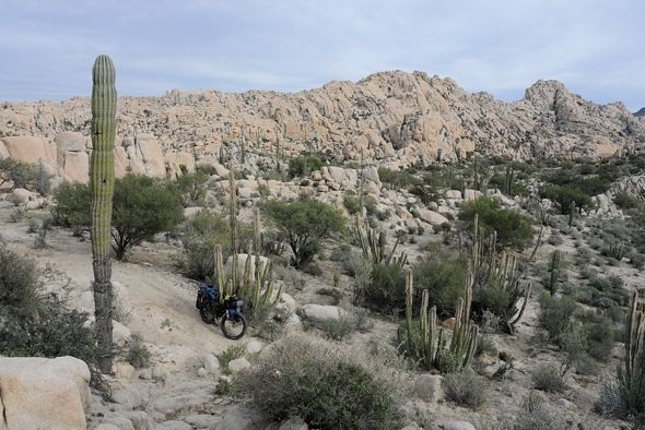
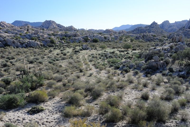
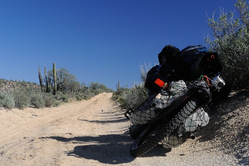
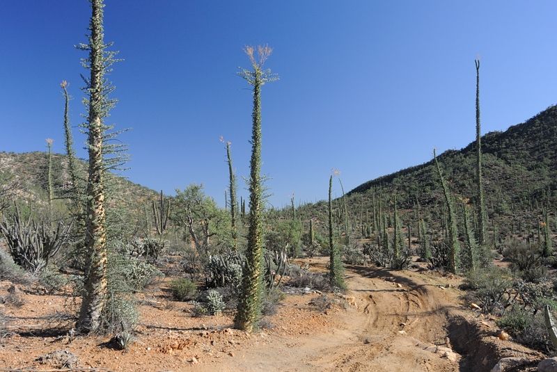
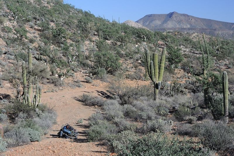
Just a couple photos from the next day. I decided to backtrack out and try from the east entrance. It would take a few days to get to Bay of LA so on
my way back out I stopped to filter some water at the stream. I went up as far as I felt like going but there was still cow chit everywhere. I know
the filter takes out multicellular organisms but not virsuses. I think cows are pretty clean but to be safe I added iodine tablets. This made the
water taste really bad so I preferentially used my clean water. It turns out that my 22 liters of water lasted almost the whole of 7 days. It worked
out to 3.5 liters per day. That's pretty good because I don't sweat much. If it was summer I'm sure I'd go through a lot more.
I went out a different way than when I came in. I followed the cow trails out and avoided the cliff. The exit is here: 29° 15.875' N 114° 0.914' W. It
was a lot longer and harder than I expected because it has to wind all back and forth around the rock formations. To go 300 m probably took 1500 m of
trail.
I took the trailer off and did it twice: once with the bike and once with the trailer. These shots are somewhere around 29° 15.685' N 114° 0.943' W
I'd encounter cows going back in as I was going out. They'd be a bit startled. With one I just waved her through and intuitively she knew what the
wave meant and relaxed. Maybe I'm a cow whisperer...
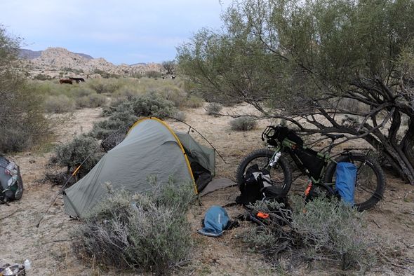
It took all day to get out. I was worried it might start raining because it was really clouding over and I swear once I felt some drizzle. So I was
racing to set up the tent. I forgot my Spot back near the first campsite I was going to set up in at the head of the canyon (decided that would be a
bad idea if it started to rain!) so I rushed back before dark and in the process screwed up the derailleur somehow so I couldn't shift the rear gears.
Here is where I ended up camping. I can't find my GPS but it was about here, with the cows in the background:
29° 15.493' N 114° 1.267' W
It was here that I learned a lesson I should have known before: don't bring a Thermarest to Mexico, it will just pop. There was lots of vegetation in
that spot, with thorns inevitably on the ground. So I had a hard bed that night. I should have brought a regular foamy that can't pop.
Also, I left the zipper open with about a 6 inch slit and I turned on my flashlight for some reason not too long after dark and a big 4" stick insect
somehow managed to get through the slit and was hanging on the inside of the tent!
It didn't rain and wasn't too windy. Tomorrow I'd see how far down the road I get.
|
|
|
Whale-ista
Super Nomad
Posts: 2009
Registered: 2-18-2013
Location: San Diego
Member Is Offline
Mood: Sunny with chance of whales
|
|
Wow, what a great adventure! Thank you for posting photos. Love the hummingbird image. Beautiful countryside.
going solo was courageous, maybe on the return you can find some companions.
What water filter did you use? Too bad about the cows- iodine flavor is hard to mask. You will definitely need more water later in the year as it
warms up. Maybe bring some of the electrolyte mixes or flavored powders to add in?
I look forward to your return.
\"Probably the airplanes will bring week-enders from Los Angeles before long, and the beautiful poor bedraggled old town will bloom with a
Floridian ugliness.\" (John Steinbeck, 1940, discussing the future of La Paz, BCS, Mexico)
|
|
|
Barry A.
Select Nomad
Posts: 10007
Registered: 11-30-2003
Location: Redding, Northern CA
Member Is Offline
Mood: optimistic
|
|
A really great report and photos. Your writing style and honesty is very refreshing, and I salute you for that. What an adventure------and what an
Adventurer you are!!!
Thank you for sharing it with all of us. Nobody ever said that particular regional geography was "easy", and you appear to be proving that in
spades!!! and your pictures reveal it--------just spectacular!!!
Barry
|
|
|
Neal Johns
Super Nomad
Posts: 1687
Registered: 10-31-2002
Location: Lytle Creek, CA
Member Is Offline
Mood: In love!
|
|
Next time - and I will never doubt you will do it again - I will try to be available to accompany/carry you to the end of the road even if there is
another vehicle along. Always better to have two vehicles. I have been in the area before.
Neal Johns aridnealATgmaildotcom
Picture is my 4x4 Tacoma pop-top camper on Mission Santa Maria "Road".
![DK Road to MSM [800x600].jpg - 39kB](https://forums.bajanomad.com/files.php?pid=880881&aid=30991 "DK Road to MSM [800x600].jpg - 39kB")
My motto:
Never let a Dragon pass by without pulling its tail!
|
|
|
Mark_BC
Nomad
Posts: 137
Registered: 12-1-2013
Location: Vancouver, BC
Member Is Offline
|
|
Thanks Neal.
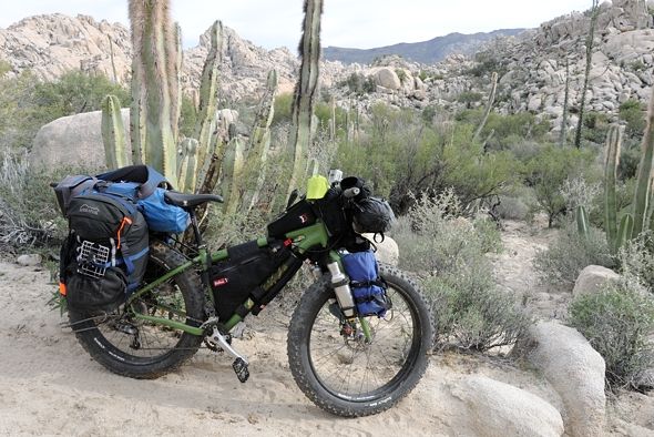
I'm uploading larger photos now. Here is a shot from the previous day with my GoPro mounted on the trailer looking forward. It is me pushing the bike
over some rocks in the wash. I think it was here: 29° 16.161' N 114° 0.579' W

The next morning I explored a little bit around the area and went up some rocks to take panorama shots. These two shots are from the same spot.
29° 15.514' N 114° 1.310' W
Looking north:
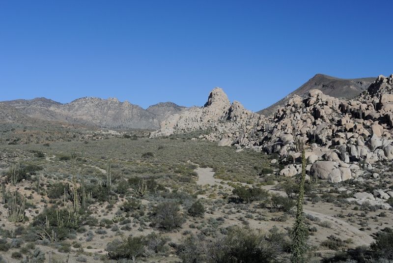
Looking south-east:
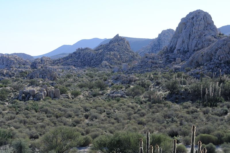
In the above photo, the highest peak on the right is probably at this location: 29° 15.350' N 114° 0.940' W so you can see how GE really levels out
the terrain! Basically, when you see rocky areas in GE you have to assume it's very steep even though the elevation information doesn't reveal that.
Looking south-east 29° 15.592' N 114° 1.203' W
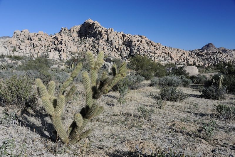
You have to watch out for those chollas! They drop off chunks that start new cholla bushes but they'll go through the bike tire pretty easily. This
was in the same vicinity.
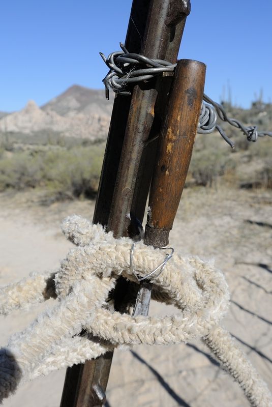
I headed back down. I should have GPS'd the gate. But it is within a few hundred meters of my campsite, at most a km. I found a chisel on the road on
the way up and forgot to see if it was Jimmy's when he came to see me. So I tied it to the gate ropes where the next person would see it.
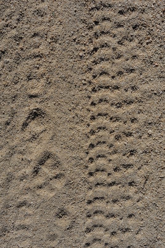
Coyote and bike tracks:
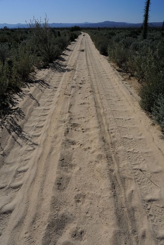
I was expecting a mostly downhill ride back out but holy cow that road sure goes up and down a lot, I guess that's why it isn't straight! It seemed
harder than coming in, but that's probably because I was expecting it to be downhill. I got a little confused when I saw more junctions than I
remember coming in. When I left the hilly area and got to the straight sections I really flew. But I still couldn't change my rear gears so I put the
chain in a middle cog and then had to get by with two gears corresponding to the two front chainrings -- low and medium. It worked OK.
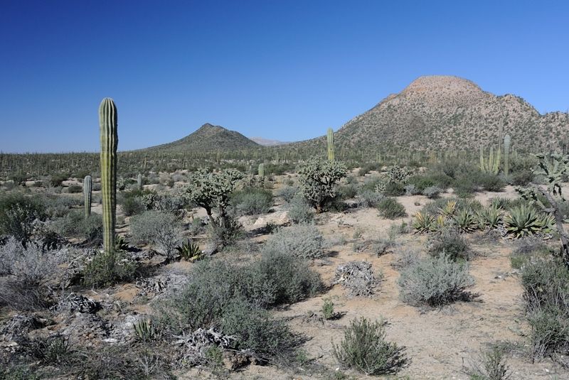
The wind was blowing hard from the north so my plan was to turn south-east at the Y junction 2 km from the highway and high tail it over with a tail
wind to the Desangano mine ruins to camp. That was a lot of fun rolling over the whoopdeedoos in the sandy track with the wind blowing from behind.
Somewhere around 29° 10.977' N 114° 5.772' W
Somewhere around 29° 8.261' N 114° 5.132' W looking north
Same spot:
I think this one was here:
29° 7.284' N 114° 2.494' W
29° 7.090' N 114° 2.240' W
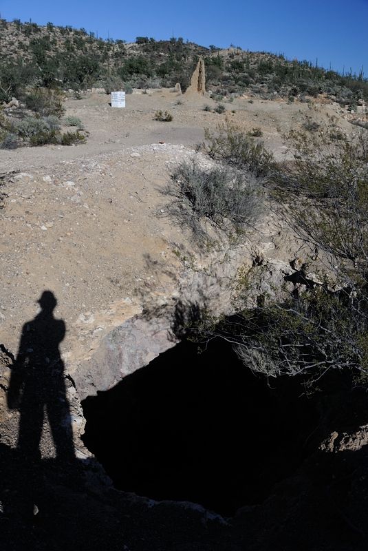
Careful where you walk. I wonder how many cows have fallen in. 29° 6.981' N 114° 1.886' W
It was pretty windy and I set up camp in the most sheltered spot I could find behind a line of trees.
|
|
|
| Pages:
1
..
10
11
12
13
14
..
25 |


