| Pages:
1
..
12
13
14
15
16
..
25 |
Ateo
Elite Nomad

Posts: 5847
Registered: 7-18-2011
Member Is Offline
|
|
WONDERFUL PHOTOS! GREAT TRIP!
|
|
|
Barry A.
Select Nomad
Posts: 10007
Registered: 11-30-2003
Location: Redding, Northern CA
Member Is Offline
Mood: optimistic
|
|
| Quote: | Originally posted by Skipjack Joe
| Quote: | Originally posted by Mark_BC
| Quote: | Originally posted by Skipjack Joe
Have you considered entering Salsipuedes from the lake just a mile north of where you came in.
29°16'2.18"N 113°55'55.68"W
I think the climb north from this spot would have been less severe. |
Hey Skipjack, I thought about that one but it looks pretty hairy entering the main canyon here: 29° 17.237' N 113° 57.989' W
Based on previous experience, if it looks at all rough on GE, it probably is very rough! But maybe with multiple people and climbing gear it would be
do-able. |
Ah yes, I saw that area as well. It looks like heavy boulders barricading the wash across the canyon. Didn't know how hard it would be to get past a
couple of such spots on that arm. |
I am still very curious about the reported guys that came up Salsipuedes from the sea and ended up on Botica Dry lake, but not via Botica Canyon as
ESG and crew did.?!?!?!?!? Am I getting confused here? Was that not reported by the BOLA guys??
Barry
|
|
|
Skipjack Joe
Elite Nomad
Posts: 8084
Registered: 7-12-2004
Location: Bahia Asuncion
Member Is Offline
|
|
Don't mean to insult your intelligence and you most likely know this, but ...
If you zoom in close to the ground in google earth and then tilt your viewpoint forward using the topmost circle with the N on it. You can then move
forward at a constant elevation and see your intended journey at a height of, say, 50 feet.
You indicated that the real world looks very different than GE. Perhaps that's because you are always looking straight down.
|
|
|
Mark_BC
Nomad
Posts: 137
Registered: 12-1-2013
Location: Vancouver, BC
Member Is Offline
|
|
| Quote: | Originally posted by Barry A.
I am still very curious about the reported guys that came up Salsipuedes from the sea and ended up on Botica Dry lake, but not via Botica Canyon as
ESG and crew did.?!?!?!?!? Am I getting confused here? Was that not reported by the BOLA guys??
Barry |
I wonder if they came up this arm and then hopped east over to Botica Wash:
29°20'23.06" N 113°56'56.36" W
|
|
|
Mark_BC
Nomad
Posts: 137
Registered: 12-1-2013
Location: Vancouver, BC
Member Is Offline
|
|
| Quote: | Originally posted by Skipjack Joe
Don't mean to insult your intelligence and you most likely know this, but ...
If you zoom in close to the ground in google earth and then tilt your viewpoint forward using the topmost circle with the N on it. You can then move
forward at a constant elevation and see your intended journey at a height of, say, 50 feet.
You indicated that the real world looks very different than GE. Perhaps that's because you are always looking straight down. |
Oh yeah I look at it from all angles. That location goes down almost 100 m over about 500 m so that is a 5:1 slope which would probably mean a lot of
cliffs with the big rocks you can see on GE.
Some of the areas I went to showed hardly any hill at all but in reality it was very steep. Basically, if you see rocky terrain in GE you should
expect it to be very steep.
The second route I tried in looks more reasonable (once you get up the hill) because most of the way isn't rocky, it's more typical desert terrain
that you can walk through. You can see the big bushes on GE and the terrain is quite flat meaning the few areas that look a bit sketchy in the wash
could likely be hiked around by leaving the wash if needed.
|
|
|
Mark_BC
Nomad
Posts: 137
Registered: 12-1-2013
Location: Vancouver, BC
Member Is Offline
|
|
OK so I edited the previous posts and added coordinates where I could remember or place the photo.
|
|
|
Mark_BC
Nomad
Posts: 137
Registered: 12-1-2013
Location: Vancouver, BC
Member Is Offline
|
|
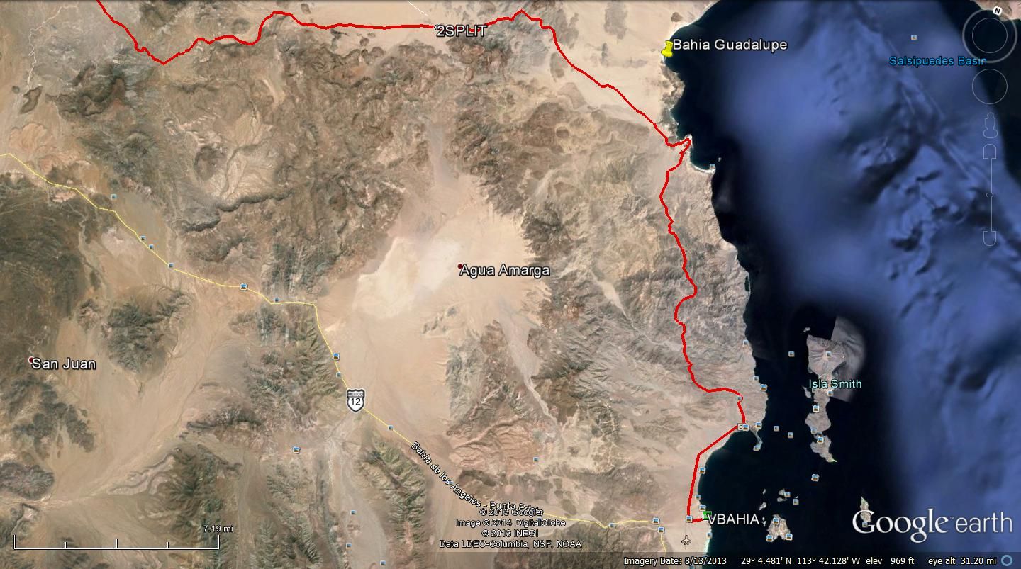
Well it looks like work is slowing down again and I should have the opportunity to try the Salsipuedes descent again, this time older and wiser. I am
thinking that I may head down in the next few weeks. I am not going to rent a car, that was too much of a noose around my neck. I am hoping to catch a
ride if one is available. Ill pay for gas etc. All youd have to do is drop me off at the side of the highway
This time I will try a different approach. I am not going to try to go down the whole drainage from headwaters to sea like last time because it is too
difficult on a first descent trip by myself. Instead Ill go in halfway down the canyon from Botica lakebed. It would be a better story to do the
whole canyon, but Id rather be able to finish the loop.
There are a few areas that look a little sketchy, like between these two locations:
29°19'22.74" N 113°58'40.57" W
And 29°20'24.43" N 113°59'25.66" W
I dont want to get down the canyon and find that its impassable again.
So I will ride my bike up the dry lakebeds from the BoLA highway to where I got last time with the car, but then go over towards ESGs campsite and
hike up the hill at the place where Eidsco has a photo on GE. From this photo you can also see that the hills arent too steep.
29°18'50.19" N 113°54'09.58" W
Then I hike north a bit and then turn west and cross over the lakebed into the drainage via this modest hill:
29°19'46.36" N 113°56'36.67" W
From there its pretty straightforward another 23 km down the wash out to the sea. I dont see anything on GE that is a cause for concern, and once I
get to Larrys photo on GE, I know Im home free because if he got there on quads Im sure a bike could get through! What Ill also do once I enter
the main drainage is turn left and go back up to see how far I can get before the terrain gets too rough. That would help with planning future
descents down the whole drainage if anyone ever decides to try that.
I will have to take all my water, so planning on around 30 L, which should last over week. On one hand, it will be warmer this time, but on the other
it wont be such hard work as last time.
Once I get to the sea I only need to packraft down to Candelero. From there I can ride up the wash but to avoid backtracking down the lakebeds I plan
to take a nicer route and cross this pass here which leads down into Bahia Guadalupe:
29°16'16.47" N 113°45'38.72" W
From Guadalupe I can ride south and go up this wash which leads to a small road:
29°07'46.31" N 113°37'19.63" W
This road goes all the way back to la Gringa.
Ive been sick almost the whole time since I got back, with the flu / bronchitis but hopefully it should soon clear up. So crossing fingers that
nothing will come up to keep me away this time.
BTW, I have been going through my video footage from the first trip and some of it turned out really well! If I get more of that on this next trip
Ill definitely have something to make a movie out of. But I need a good story to make a movie, and getting turned back by difficult rocks isnt a
good story.
|
|
|
Barry A.
Select Nomad
Posts: 10007
Registered: 11-30-2003
Location: Redding, Northern CA
Member Is Offline
Mood: optimistic
|
|
Sounds like a very workable plan, Mark. We will 'stay tuned'.
Many years ago I could never figure out how to drive directly (or even indirectly) from La Gringa to Guadelupe Bay beaches, but maybe you can
hopefully find one.
Barry
|
|
|
David K
Honored Nomad
Posts: 64479
Registered: 8-30-2002
Location: San Diego County
Member Is Offline
Mood: Have Baja Fever
|
|
Hi Mark,
I recently found that BING satellite images are newer and higher resolution than Google Earth... straight down views... You might check it out to
explore routes while you are getting over your flu. SEE this thread I made with comparison photos: http://forums.bajanomad.com/viewthread.php?tid=72226
|
|
|
Mark_BC
Nomad
Posts: 137
Registered: 12-1-2013
Location: Vancouver, BC
Member Is Offline
|
|
Barry, I traced the road from la Gringa to Guadalupe with a Google Earth kmz file, you can U2U me and I'll send it. It gets very faint up at the
Guadalupe end but it definitely enters that wash from the coordinates I gave in the last post. I guess I'll scope it out to see what kind of a vehicle
can get through. It may be only quad-passable.
David, thanks those are nice images. They seem about the same resolution as the high quality GE images but for areas where GE is low rez they will
definitely help out. Doesn't appear to be elevation data though so you can't tilt to get a sense of the terrain.
|
|
|
Skipjack Joe
Elite Nomad
Posts: 8084
Registered: 7-12-2004
Location: Bahia Asuncion
Member Is Offline
|
|
| Quote: |
I dont want to get down the canyon and find that its impassable again.
So I will ride my bike up the dry lakebeds from the BoLA highway to where I got last time with the car, but then go over towards ESGs campsite and
hike up the hill at the place where Eidsco has a photo on GE. From this photo you can also see that the hills arent too steep.
29°18'50.19" N 113°54'09.58" W
|
This looks like a difficult area to me. It will be interesting to see what you think of it.
|
|
|
larryC
Super Nomad
Posts: 1482
Registered: 8-11-2008
Location: BoLA
Member Is Offline
|
|
Mark
Once you make it to Botica dry lake the only rough spot you will encounter is the 40' cliff that ESG had to lower his packjacks over. Once past that
it is smooth sailing. Have fun.
Larry
Off grid, 12-190 watt evergreen solar panels on solar trackers, 2-3648 stacked Outback inverters, 610ah LiFePo4 48v battery bank, FM 60 and MX60
Outback charge controllers, X-240 Outback transformer for 240v from inverters, 6500 watt Kubota diesel generator.
|
|
|
TMW
Select Nomad
Posts: 10659
Registered: 9-1-2003
Location: Bakersfield, CA
Member Is Offline
|
|
The Bill Nichols motorcycle trail goes from LA Bay to the Bahia Guadalupe area. Here is a GE view of it. I'm sure there are a couple of places a 4
wheeler can't get thru.
|
|
|
Neal Johns
Super Nomad
Posts: 1687
Registered: 10-31-2002
Location: Lytle Creek, CA
Member Is Offline
Mood: In love!
|
|
Mark,
The below coordinate does not look right when plotted on GE. Could it be a mistake?
| Quote: |
Then I hike north a bit and then turn west and cross over the lakebed into the drainage via this modest hill: 29°19'46.36" N 113°56'36.67" W
|
My motto:
Never let a Dragon pass by without pulling its tail!
|
|
|
Mark_BC
Nomad
Posts: 137
Registered: 12-1-2013
Location: Vancouver, BC
Member Is Offline
|
|
Yes that's the right coordinate. If you tilt GE you see that the hills north of that spot are a little steep, so that is the easiest entry point I
think. I'd go up from the lakebed via this little wash:
29°20'34.89" N 113°55'47.74" W
I was also looking around and it looks like Asamblea would be an interesting but more challenging trip. You'd enter here from the road:
29°17'54.59" N 114°01'33.52" W
The next few km after that look the most challenging, so if you make it through that you are probably OK. It would be a long twisty journey, it must
be like being in one of those hedge mazes that never ends.
There is an oasis here:
29°22'57.08" N 113°58'17.80" W
Then when you get here turn left:
29°25'18.04" N 113°56'28.68" W
Follow this wash up until here and turn north and cross into the next drainage:
29°26'09.94" N 113°58'41.48" W
Then follow this to the sea:
29°31'11.53" N 113°55'55.29" W
From there you could packraft up to the Calamajue area and ride out, or make your way over to Punta Final.
But first I want to get down Salsipuedes!
|
|
|
Mark_BC
Nomad
Posts: 137
Registered: 12-1-2013
Location: Vancouver, BC
Member Is Offline
|
|
OK, it's on. I fly to Las Vegas on Thursday and Mark will give me a ride to San Diego where John Mcfrog is giving me a ride down. We leave Friday
early am then drive non-stop to the BoLA turnoff, and camp around the Mission San Borja road. Then Saturday I'll say goodbye and head off up the dry
lakebed. I hope to get all the way to ESG's campsite that day, it is 40 km which should be do-able if there is no headwind.
29°18'13.47" N 113°54'13.66" W
Then the next day, Sunday, I'll hike my stuff up the hill, 150 m so shouldn't be too bad. Then I'll ride west into Salsipuedes from the Botica
lakebed. Once I'm in the wash I will make a B line for this corner here which looks like a cliff:
29°22'14.13" N 113°57'04.09" W
If it's passable then I know I'll be home free because I don't see any other obstacles up until Larry's photo, and if he got there with quads then I
can get down with a bike. Then I can commit to going down and not have to worry about getting stuck and running out of water.
After I confirm that corner is passable I'll go back up the main Salsipuedes canyon and see how far I can get. Then I'll head back down to the
confluence with the Asamblea. I'd like to go up that one as far as I can as well. I'm also intrigued about the overland crossing to the next drainage
north...
So we'll see how it goes, I'll figure it out once I'm in there. I think I should be able to do a lot of exploration since it isn't hard to ride 20 km
a day if it's just sandy with no rocks. So I should be able to go all over that canyon network in fairly good time.
It's going to be quite a bit hotter this time so I'll have to be careful with water. I am going to lug a ton of it over from the highway and stash at
the bottom of the hill at ESG's campsite, shouldn't be too hard to do since it is a flat road. I'm a little unsure though how to determine if the
water I might find from an oasis has mineral contamination. I'd like to go up to that oasis up Asamblea, if I could find water there that would be
awesome, it would really provide a nice buffer of safety.
29°22'57.02" N 113°58'18.21" W
Then in mid-April Mark and Morgan and the gang will come down to Guadalupe where I'll meet them and hang out for a few days and then go back with
them! Not sure if I'll take a break after a couple weeks and resupply in Bay of LA or not, or if I'll just spend a whole month out there. My food will
run out after 2 weeks so I'd have to survive on fish. Can't complain about that!
|
|
|
motoged
Elite Nomad
Posts: 6481
Registered: 7-31-2006
Location: Kamloops, BC
Member Is Offline
Mood: Gettin' Better
|
|
| Quote: | Originally posted by TW
The Bill Nichols motorcycle trail goes from LA Bay to the Bahia Guadalupe area. .... |
Tdubbya,
Is that the Window Rock Trail?
Don't believe everything you think....
|
|
|
woody with a view
PITA Nomad
Posts: 15937
Registered: 11-8-2004
Location: Looking at the Coronado Islands
Member Is Offline
Mood: Everchangin'
|
|
how do you protect you stash of water from coyotes and other critters?
|
|
|
larryC
Super Nomad
Posts: 1482
Registered: 8-11-2008
Location: BoLA
Member Is Offline
|
|
Mark
You won't have any trouble going down the Botica dry wash, easy, sand and a gentle down slope until you get to the cliff near the bottom. Once down
the cliff it is pretty simple over to the entrance to Salsipuedes and then the first branch to the right is Asamblea. If you take the branch to the
right you end up at the ranches where you started your last trip. You know what obsticles to expect up there. If you go up Salsipuedes you will end up
at the Botica dry lake and you will again be in familiar territory. Trying to travel along the coast from the mouth of salsipuedes on down to
Guadalupe will be rugged. there will be lots of boats fishing in the area so some help will probably be available. Good luck and keep us posted.
Larry
Off grid, 12-190 watt evergreen solar panels on solar trackers, 2-3648 stacked Outback inverters, 610ah LiFePo4 48v battery bank, FM 60 and MX60
Outback charge controllers, X-240 Outback transformer for 240v from inverters, 6500 watt Kubota diesel generator.
|
|
|
JohnMcfrog
Nomad
Posts: 156
Registered: 8-1-2012
Location: San Diego, Punta Abreojos
Member Is Offline
|
|
Thanks to David K for some good info. Getting stoaked for this trip with Mark. Life is definitely good.
|
|
|
| Pages:
1
..
12
13
14
15
16
..
25 |