| Pages:
1
2 |
Emerson
Junior Nomad

Posts: 42
Registered: 6-24-2013
Member Is Offline
|
|
El Mano Pass, Secret Origins Unveiled
Well, after endless hours of searching the web, digging information, I found it; it makes reference to the actual origin of its name "El Mano"; also
it explains in detail when ,why and for what reason that road was built; I found it on a book that you may be interested in, unfortunately its in
Spanish, its called "El Reino de las Calafias", it was written by a local writer that participated in a set of Off Road explorations done in the late
90's early 2000's to several scenic places in the Baja region, all of their trips are backed up with a lot of information about the area's history and
tons of detail.
Anyway, the history of the road goes like this, As you may know, most of the land facing east in Sierra de Juarez is called "Cordillera Molina", the
Molina family owned most part of the mountain facing the canyon side, they arrived in the area in the early 40's, to everybody surprise, they werent
the first ones on the area, there was an old gold miner that called himself "El Mano", he lived around the canyon area that later adopted his name; he
then died in a mysterious way (?).
During many years of growing cattle in these rocky sections, the Molina family got surrounded by other people and then formed the "Ejido Cordillera
Molina" as a set of ranchers in the same area.
Loreto Molina and his sons built some small houses on the foot of the mountain "El Mano" canyon range, in a small oasis filled with Palms, then a
couple more the top of the "Cerro Negro" mountain, a black and flat hill; they used to call them "Molina de Abajo" and "Molina de Arriba". (Up &
Down)
In the mid 70's a "Compadre" of Molina, was the head of the National Commission for Arid Zones, and he agreed on a request of building a road that
connected both upper and lower houses, only connected back then by a primitive horse trail; that meant a significant deal of work thru the Sierra de
Juarez, nevertheless, the machinery and workforce was capable to perform the task; at first, the Molina family placed a chain in order to prevent
traffic going thru that road, and afterwords it was left open for normal traffic.
This was the third access road thru the Juarez mountains, first came San Matias Pass, then, La Rumorosa, formerly called "Alducin" Grade; and then
last this "Mano" pass...
Its very amazing to learn that that little road, that meant a great deal of investment and labor was built just to help a Compadre back in the day.
We recently did a trip, travelling from Laguna Hanson, east to Rancho Los Pinos and the down thru el Mano pass, getting from Laguna Hanson to Rancho
Los Pinos is really confusing, theres thousands of roads interconnecting and many gated ranchos, we just got kicked out from Rancho Cuevitas, and
travelled a very very old road that was very washed out, but hey, without that, the trip was going to be too easy! Once we reached Ranchos Los Pinos
and we headed down the condition of the road degraded a bit, due to the races I believe, actually, its my second time going thru this road, my first
time was I was going up, in the dark!; this time around I could finally appreciate the beautiful scenery of the area, just impressive.
Once in the desert floor, we headed south to Isabel Canyon, we camped on the old Governor House, sometime called Lodge, I just observed PaulW wrote
about it, the house and land actually was officially owned by the Head of Natural Resources back on the 80s; he passed away a couple of years back;
that property and lodge was very controversial back in the day. I dont know, that kind of luxury that far away just gets you thinking, right?
After some web digging, theres some info available and you can tie knots, and then everything makes sense on why and for who it was built; anyway
its a nice place to visit! Ha!
Some pics...I hope they work this time


Thanks for reading.
-Emerson.
[Edited on 12-10-2013 by Emerson]
|
|
|
David K
Honored Nomad
Posts: 65561
Registered: 8-30-2002
Location: San Diego County
Member Is Offline
Mood: Have Baja Fever
|
|
Wonderful history! Please contact me to help you with photos.
There is one more old road down the Sierra Juarez: The 'Pole Line Road' built in 1942 from Ensenada to San Felipe utilizing Portezuelo de Jamau, east
of Santa Catarina and Independencia. It was for communications to the U.S. radar station at Punta Diggs (near San Felipe/Punta Estrella).
|
|
|
Mexitron
Ultra Nomad
Posts: 3397
Registered: 9-21-2003
Location: Fort Worth, Texas
Member Is Offline
Mood: Happy!
|
|
Good to know, thanks for digging through all the history. Quite a fun road. I remember seeing both ranchos. I can't get your pix to show up on my
computer though.
|
|
|
Emerson
Junior Nomad
Posts: 42
Registered: 6-24-2013
Member Is Offline
|
|
Thanks, we did the Pole Line Road on April '12; almost perfect except we got lost on the desert floor looking for the Mano grade entrance, found it,
got to the top around 2am, needless to say we couldnt find our way to Laguna Hanson, in the morning we bailed to Heroes de Independencia with the last
milliliters of gas we had left, refuled and headed back to Laguna Hanson thru Ojos Negros... will try it again soon!
|
|
|
David K
Honored Nomad
Posts: 65561
Registered: 8-30-2002
Location: San Diego County
Member Is Offline
Mood: Have Baja Fever
|
|
Photo links, click to view...
https://www.dropbox.com/s/t8frji54bjkz8t9/IMG_2342.JPG
https://www.dropbox.com/s/v236uu5kd5kse0d/IMG_2343.JPG
https://www.dropbox.com/s/fwe3f24xln26m4h/IMG_2348.JPG
https://www.dropbox.com/s/2ag228ghhp627we/IMG_2353.JPG
https://www.dropbox.com/s/amjlva34hvjjwu2/IMG_2354.JPG
https://www.dropbox.com/s/nrekdiyx3e0j7ii/IMG_2361.JPG
https://www.dropbox.com/s/xuzdwu6pwtaukfr/IMG_2410.JPG
https://www.dropbox.com/s/snw9uuflgb5edes/IMG_2419.JPG
https://www.dropbox.com/s/o53g19iixf3df6s/IMG_2424.JPG
|
|
|
David K
Honored Nomad
Posts: 65561
Registered: 8-30-2002
Location: San Diego County
Member Is Offline
Mood: Have Baja Fever
|
|
OK... the secret to using Drop Box to post photos is to use the 'Share Link' URL. On Photobucket.com it is the IMG URL. Thanks to BajaNomad Doug for
that info...
|
|
|
Taco de Baja
Super Nomad
Posts: 1913
Registered: 4-14-2004
Location: Behind the Orange Curtain, CA
Member Is Offline
Mood: Dreamin' of Baja
|
|
| Quote: | Originally posted by Emerson
Thanks, we did the Pole Line Road on April '12; almost perfect except we got lost on the desert floor looking for the Mano grade entrance, found it,
got to the top around 2am, needless to say we couldnt find our way to Laguna Hanson, in the morning we bailed to Heroes de Independencia with the last
milliliters of gas we had left, refuled and headed back to Laguna Hanson thru Ojos Negros... will try it again soon! |
Thanks for the history on the El Mano road.
Mexitron and I went down El Mano, went to Agua Caliente, and then did the Pole line at the very beginning of April 2012, so we probably just missed
each other! 
Did you see all the road repairs and brush trimming we did? 
[Edited on 12-10-2013 by Taco de Baja]
Truth generally lies in the coordination of antagonistic opinions
-Herbert Spencer
|
|
|
TMW
Select Nomad
Posts: 10659
Registered: 9-1-2003
Location: Bakersfield, CA
Member Is Offline
|
|
Really good stuff, thanks. Thanks DK for getting the pictures, beautiful.
|
|
|
Neal Johns
Super Nomad
Posts: 1687
Registered: 10-31-2002
Location: Lytle Creek, CA
Member Is Offline
Mood: In love!
|
|
Many thanks, I had no idea of the road's history. Been up it a couple of times. Easy to find the bottom on Google Earth. Let's hear it for Google
Earth, sure saves gas! 
Neal
My motto:
Never let a Dragon pass by without pulling its tail!
|
|
|
DEVEAU
Nomad
Posts: 104
Registered: 11-29-2005
Member Is Offline
Mood: "WFO"
|
|
I thought there were 4 passes not counting San Matias. We have ridden them over the years.
La Rumorosa
El Mano if that was the SCORE course this year
The Pole Line, we called it the grade
Another North of El Mano, found it about 6 years ago, very steep switchbacks, can see Laguna Salada from the top
Will file a trip report from our Thanksgiving ride this weekend.
Chase Trucks? ??
We don\'t need no stinking chase trucks!
|
|
|
Neal Johns
Super Nomad
Posts: 1687
Registered: 10-31-2002
Location: Lytle Creek, CA
Member Is Offline
Mood: In love!
|
|
DEVEAU,
The Pole Line went over the Jamau Grade (your Grade maybe), Nomad Squarecircle is the only other one I know who has driven it.
My motto:
Never let a Dragon pass by without pulling its tail!
|
|
|
DEVEAU
Nomad
Posts: 104
Registered: 11-29-2005
Member Is Offline
Mood: "WFO"
|
|
We have done it on Motorcycles a few times. My brother swears he can see a road heading due East from the bottom instead of going North toTres Pozas.
I think I can see it on my giant wall map, TPC H-22A.
It's the one between El Mano and La Rumorosa I'm wondering about. The year we rode it we had an early start and heading North from Santa Catarina
three of us just kept taking every right turn we could. It did not look like El Mano, much straighter drop to the dry lake.
Chase Trucks? ??
We don\'t need no stinking chase trucks!
|
|
|
David K
Honored Nomad
Posts: 65561
Registered: 8-30-2002
Location: San Diego County
Member Is Offline
Mood: Have Baja Fever
|
|
The Squarecircle told me of another grade, but I thought it was south of the Pole Line Grade (Portezuelo de Jamau, aka 'The Summit' by SCORE)... You
can see it on Google Earth...
Roy, you get the computer working yet?
|
|
|
Maderita
Senior Nomad
Posts: 704
Registered: 12-14-2008
Location: San Diego
Member Is Offline
|
|
Deveau,
When you wrote aboute 4 passes, is "La Rumorosa" referring to the highway (Cantú grade, aka: Alducin)? If so, then add another pass to the list.
There is a dirt road which starts from the La Rumorosa municipal dump and drops down a canyon to the desert floor. It was not gated when I drove it
15+ years ago. It was 2WD, though I used low range for engine braking. I have no idea about the current status.
Does anyone know the name of that road, or the name of the canyon? It may be the north fork of Cañon de Llanos.
|
|
|
David K
Honored Nomad
Posts: 65561
Registered: 8-30-2002
Location: San Diego County
Member Is Offline
Mood: Have Baja Fever
|
|
| Quote: | Originally posted by Maderita
Deveau,
When you wrote aboute 4 passes, is "La Rumorosa" referring to the highway (Cantú grade, aka: Alducin)? If so, then add another pass to the list.
There is a dirt road which starts from the La Rumorosa municipal dump and drops down a canyon to the desert floor. It was not gated when I drove it
15+ years ago. It was 2WD, though I used low range for engine braking. I have no idea about the current status.
Does anyone know the name of that road, or the name of the canyon? It may be the north fork of Cañon de Llanos. |
That dirt grade from La Rumorosa to the desert was used for the Baja 1000, and I have seen Mexican 4WD clubs post photos of driving it. So, yes...
there's another way from top to bottom!
|
|
|
Maderita
Senior Nomad
Posts: 704
Registered: 12-14-2008
Location: San Diego
Member Is Offline
|
|
Yes, a Baja 1000 used that road in the 1990's.
|
|
|
DEVEAU
Nomad
Posts: 104
Registered: 11-29-2005
Member Is Offline
Mood: "WFO"
|
|
Oops, yes I have ridden both the dirt and paved La Rumorosa. So that's 5 not counting
San Matias. Could be one more in the South.
Chase Trucks? ??
We don\'t need no stinking chase trucks!
|
|
|
TMW
Select Nomad
Posts: 10659
Registered: 9-1-2003
Location: Bakersfield, CA
Member Is Offline
|
|
There is another as David K mentioned south of the summit or pole line road as some refer. It was going to be used in a mid-90s Baja 500 race but too
many racers complained on how rough it was. I have driven it and rode it a couple of times several years ago. I call it the south summit. On google
earth look for the trail coming out of the wash at the bottom of the summit going SE on the pole line road. It's only maybe 1/4 to 1/2 mile from the
wash going west.
|
|
|
TMW
Select Nomad
Posts: 10659
Registered: 9-1-2003
Location: Bakersfield, CA
Member Is Offline
|
|
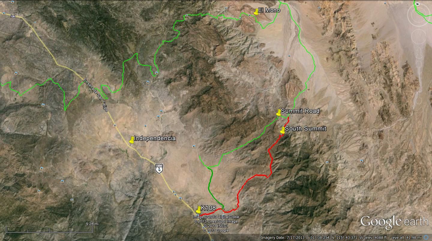
Here are the three trails down to the desert floor with El Mono at the top, the Summit in the middle and the lower Summit at the bottom.
|
|
|
David K
Honored Nomad
Posts: 65561
Registered: 8-30-2002
Location: San Diego County
Member Is Offline
Mood: Have Baja Fever
|
|
I found 8 roads from the top of the Sierra Juarez to the desert floor, between the U.S. border and Hwy. 3 (San Matias Pass):
I am going to show you with Google Earth images... stand by.
Hwy. 2-D
Graded dirt road from La Rumorosa
Mano Canyon
Pole Line Road
Dirt Rd. A ('South Summit')? (to Pole Line)
Dirt Rd. B (to Pole Line)
Dirt Rd. C (does not continue all the way into the San Felipe Desert)
Dirt Rd. D (Joins the Arroyo Grande road)
I added a second marker for each of the roads A, B, C, D on the desert side of the grade.
|
|
|
| Pages:
1
2 |


