| Pages:
1
2 |
philodog
Nomad

Posts: 163
Registered: 10-9-2010
Member Is Offline
|
|
Mexicali to La Paz, off the beaten path camping
We love traveling slow on the long drive south and venturing down primitive roads, seeing what there is to find. But for years we have selfishly kept
favorite camp spots a close held secret, not wanting them to get 'discovered'. Over the past few years though several spots have become inaccessible,
fenced off by big landowners, so before they are all gone I figured I might as well share some of them. And besides, the people who would take the
effort to get to these spots are probably people I would want to meet anyway. The camp spots vary from year to year depending on where we are in the
late afternoon. The criteria for a good camp spot are that it has to be invisible from the main road and away from any kind of civilization but not
so far as to make getting there a trip in itself. Bonuses are ocean front, good surf, running water, natural beauty, canyons to explore etc. These
are this year`s crop. None are suitable for travel trailers or RVs.
For the past five years we have crossed at Mexicali and can never see using Mex 1 again. At the east crossing there has never been even one
person in front of us at the border, immigracion or the bank. There is ample parking for a truck and trailer and it`s easy to get out of town from
there. Once out of Mexicali it is ridiculous how few cars are on the road all the way to Hwy 1 at Laguna Chapala. There are no cities to pass through,
no trucks or buses, and no hills or curves until the last 35 miles. Those 35 miles of rough dirt road are the savior of this piece of country. Once
that section is paved it will be the most crowded piece of highway in Baja. It`s a slow 35 miles, four hours towing our cargo trailer but we have
time. All the tires are aired down to 18 psi and if we need to crawl at 1mph to make it safe and comfortable so be it. Instead of counting the hours
or miles we measured time by the number of This American Life podcasts it took to get there (3).
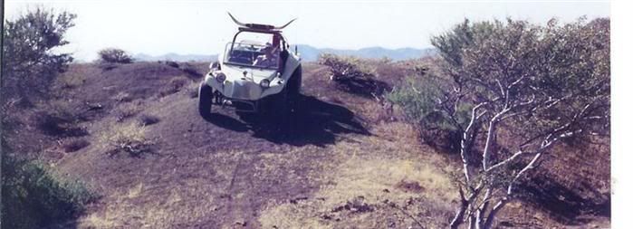
Our first night was spent at an amazing little hidden canyon a couple miles before Coco`s. It`s on the left, an almost invisible track that
immediately turns a corner and hides you from the road. The canyon opens up with plenty of flat space and almost enough room to turn around in. A
short hike up the canyon reveals rock work very similar to Joshua Tree National Park on a smaller scale and with that spectacular Baja desert
vegetation.

The next day starts with the slow grind out to HIghway One at Laguna Chapala. A local in a pick up truck flew by us in a hurry to who knows where
and paid the price a few miles down the road with a mangled suspension. We were barely able to squeak by on the steepest section of road of the whole
40 miles and then gave him a ride the last eight miles to the llantera at the intersection with Mex 1. The mechanic there obviously was used to this
scenario and said (in perfect English) that he would take care of him. We aired up and continued on.
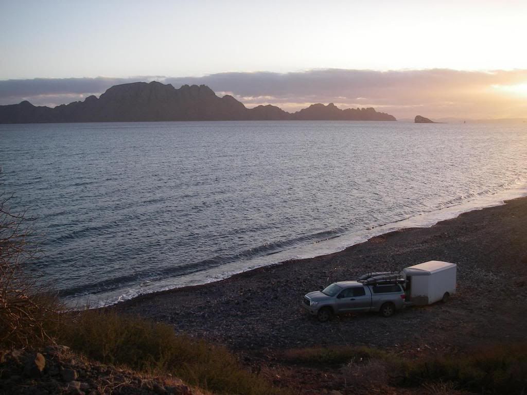
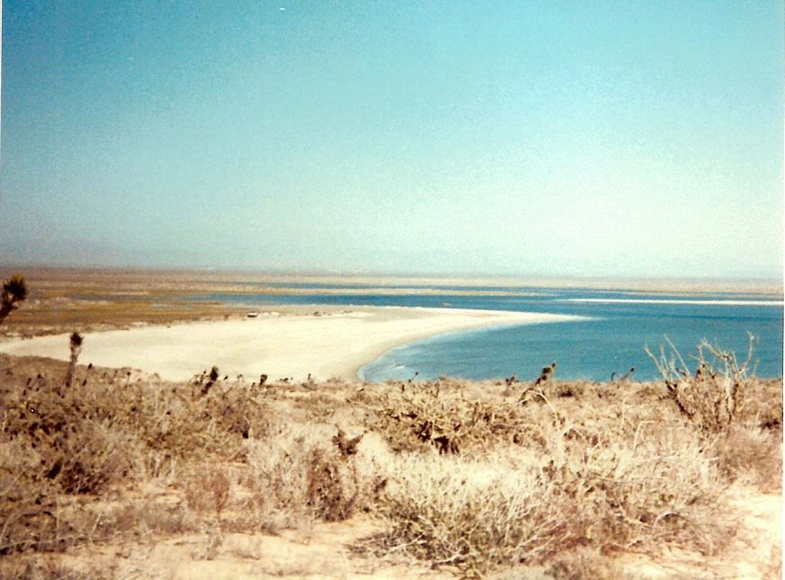
Night two we always spend at the lighthouse at Laguna Manuela. It`s not exactly a secret spot but because it entails a normally washboarded 11
mile drive in (this year was freshly graded and smooth sailing) and requires 4wd to get up the sandy road to the lighthouse we have never encountered
another camper there. And the fog, wind and copious nightime dew may deter less than hardy campers. In my opinion it is one of the most spectacular
ocean views on the coast. I will venture a guess that one can see more coastline from there than from any other spot in Baja. From G. Negro out to
Punta Eugenia on the south, Isla Cedros to the west and north up to who knows where on a clear day. Punta San Carlos maybe? The vegetation is very
stark but the shoreline makes up for it with a white sandy beach then a dark volcanic rocky point repeated a dozen times. And the surf ain`t bad
either.


Day three starts out with airing up again at the Pemex in Jesus Villa Maria and heading to Loreto. There are many hidden gems along the beach south
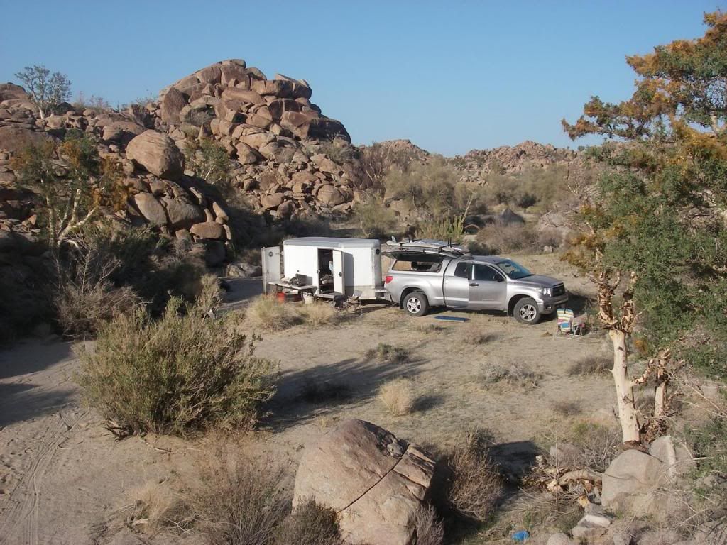
of town (but getting fewer every year) and this year`s choice was below the large mystery rock structure at KM 89. It`s only a half mile off the road
but a rocky 200 yard section makes it a 10 minute drive and rules out any RVs venturing in. Total seclusion with the islands on one side, the Giganta
on the other and the sea 10 feet from camp. This spot won`t be around for too much longer.

Day four is an easy drive to La Paz with a mandatory stop at either Tacos Hermanos Gonzalez or Los Molcahetes right as you enter civilization on the
outskirts of La Paz. Hermanos Gonzales is the best taco stand around run by brother and sister Geronimo and Geronima (they say their father was a
little crazy). Killer ceviche and fresh squeezed OJ too! Los Molcahetes, a few hundred yards down the road on the left, is a sit down place with
some amazing and original Jalisco dishes at cheap prices and wonderful friendly service. Then to La Ventana for a couple of months of windsurfing
before heading home and finding new spots.
Get out and explore!
[Edited on 3-6-2014 by BajaNomad]
|
|
|
Skipjack Joe
Elite Nomad
Posts: 8084
Registered: 7-12-2004
Location: Bahia Asuncion
Member Is Offline
|
|
| Quote: | Originally posted by philodog
|
Did you catch anything at this spot?
We've had luck there at times and nothing at other times. I'm not sure why.
|
|
|
philodog
Nomad
Posts: 163
Registered: 10-9-2010
Member Is Offline
|
|
Nothing on the ocean side this time. Next year I`m going to try the lagoon on a kayak. Looks much more promising.
|
|
|
monoloco
Elite Nomad
Posts: 6667
Registered: 7-13-2009
Location: Pescadero BCS
Member Is Offline
|
|
Love your photos. Thanks for sharing!
"The future ain't what it used to be"
|
|
|
Cliffy
Senior Nomad
Posts: 980
Registered: 12-19-2013
Member Is Offline
|
|
philodog- cool report Thanks!
I don't suppose there is any way to drag my 20 ft travel trailer through from Gonzaga to Mex 1 without tearing it up is there? You mage it with your
cargo box but I'm thinking even if I go sloooow it won't work for me. At the very least I'd ruin my tires is my guess.
Maybe we need to start a fund for 1 guy and a road grader there :-)
|
|
|
Skipjack Joe
Elite Nomad
Posts: 8084
Registered: 7-12-2004
Location: Bahia Asuncion
Member Is Offline
|
|
| Quote: | Originally posted by philodog
Nothing on the ocean side this time. Next year I`m going to try the lagoon on a kayak. Looks much more promising. |
The lagoon is not as good as it had been as little as 10 years ago. But I believe that's mostly around the mouth and a bit further in to where the
dirt roads now reach. If, however, you paddle into it much deeper you should still encounter good fishing. Use plastic grubs in there.
|
|
|
TMW
Select Nomad
Posts: 10659
Registered: 9-1-2003
Location: Bakersfield, CA
Member Is Offline
|
|
Beautiful pictures and places to camp, thanks.
As far as Laguna Manuela fishing we use to catch a good amount yellow, spots and corbina at one of the coves where the seals are. But that was a few
years ago.
|
|
|
David K
Honored Nomad
Posts: 64547
Registered: 8-30-2002
Location: San Diego County
Member Is Offline
Mood: Have Baja Fever
|
|
Thank you for the report... the photos are beautiful, albeit bigger than Nomad's max so reading is difficult. None-the-less, thank you and you have
good Baja attitude to enjoy the way it is/ was/ used to be before stupid things like road graders and asphalt pavers!
|
|
|
philodog
Nomad
Posts: 163
Registered: 10-9-2010
Member Is Offline
|
|
Cliffy, definitely wouldn`t go with the travel trailer if you want to keep it in the same condition it is now. Though there was a semi with an empty
trailer starting in from Chapala. Going about 1/2 mile an hour. Thank god we passed him while it was still wide enough.
David, I tried following your instructions for pics from Photobucket but it never gave me an option for file size like it did in your instructional. I
swear I tried several times!
|
|
|
flyguy
Junior Nomad
Posts: 34
Registered: 1-2-2014
Location: BC, Canada
Member Is Offline
|
|
Great trip report Philodog! Btw the picture sizing stumped me for a while also ... It actually doesn't ask you, you must click the 'cog' in the top
right corner when uploading 
|
|
|
David K
Honored Nomad
Posts: 64547
Registered: 8-30-2002
Location: San Diego County
Member Is Offline
Mood: Have Baja Fever
|
|
| Quote: | Originally posted by soulpatch
Awesome. Pics look fine here! Too fine.... darn it!
|
Yah, Doug resized them to fit on the page... they are perfect now.
Philo, next time you upload to Photobucket, click on the little gear in the corner and set the upload size to 800 pixels (full page wide photo) or 640
pixels (large size photo withing the Nomad page)... click save... and then all future Nomad photo posts from you won't need to be edited.
Thanks again for the great pics!
|
|
|
bajaemma
Newbie
Posts: 19
Registered: 2-25-2013
Member Is Offline
|
|
Loved your report getting ready for my yearly 2 week trip--excited to go down the "east side" wow Baja is an amazing place . Thank you!!!!!!!!!
|
|
|
Bajaboy
Ultra Nomad
Posts: 4375
Registered: 10-9-2003
Location: Bahia Asuncion, BCS, Mexico
Member Is Offline
|
|
Good stuff...heading down in a few weeks and plan on exploring a bit.
|
|
|
DawnPatrol
Nomad
Posts: 357
Registered: 11-19-2013
Member Is Offline
|
|
Loved all of it Philodog.... please keep reporting spots
I really dont think they will be overrun... too few people still venturing South, which to me is a great thing
Alan from SanDiego
[Edited on 3-8-2014 by DawnPatrol]
[Edited on 3-8-2014 by DawnPatrol]
|
|
|
Pompano
Elite Nomad
Posts: 8194
Registered: 11-14-2004
Location: Bay of Conception and Up North
Member Is Offline
Mood: Optimistic
|
|
Great trip report, philodog.
I was particularly glad to hear that the Laguna Manuela area you reported on is still 'off-the-beaten-path'. It was a favorite beachcombing and
camping spot for many of us from Mulege in the 70's and 80's. We drove in the washboard trail from Jesus Maria very slowly...taking care not to break
any dishes in the various camping rigs. As I remember, we were always the only ones camping in the area. Took some nice sidetrips up to Tomatal for
albalone.
I took this gruesome photo which shows the lagoon was an active shark fishery at that time. Naturally, that fishery was not self-sustaining. 

We used to roam the long beach you spoke of...Playa Largo...and surf-fish. Caught some large white sea bass. I recall one morning fishing there and
getting my dune-buggy stuck near the water's edge at low-tide. I was bottomed out and about to toast the buggy 'adios' with a Pacifico when a
truckload of locals came by on the coast trail and literally picked that buggy up and put it back on the hardpack. We invited the crew to dinner that
night. What a day! What fine folks!
Later, an old amigo, Riley, and his family moved there from Conception Bay and settled near that lighthouse. Known to the locals as Perico Blanco,
white parrot, because of his startling hair style. Regretted hearing from the Pemex folks that his wife had passed and he went back to the states.
Thanks for the memories, philodog, and please keep up your informative & valuable trip reports.
I do what the voices in my tackle box tell me.
|
|
|
Ateo
Elite Nomad
Posts: 5851
Registered: 7-18-2011
Member Is Offline
|
|
Nice desolation! Thanks for sharing with us.
|
|
|
Mark_BC
Nomad
Posts: 137
Registered: 12-1-2013
Location: Vancouver, BC
Member Is Offline
|
|
| Quote: | Originally posted by Pompano
I took this gruesome photo which shows the lagoon was an active shark fishery at that time. Naturally, that fishery was not self-sustaining.
|
Last year we went down there looking for the shark head dump. It is along one of the roads out there. On previous trips Mark found some baby great
white heads in amongst the makos and blues. Now it seems to just be blues and makos. We took the more rotten ones and soaked them in some seawater for
the rest of the trip. Then the teeth fall out and you have a bunch of shark teeth.
But now that dump isn't used anymore. I don't know if there's another one instead or if they just ran out of sharks.
|
|
|
TMW
Select Nomad
Posts: 10659
Registered: 9-1-2003
Location: Bakersfield, CA
Member Is Offline
|
|
Pompano
["Later, an old amigo, Riley, and his family moved there from Conception Bay and settled near that lighthouse. Known to the locals as Perico Blanco,
white parrot, because of his startling hair style. Regretted hearing from the Pemex folks that his wife had passed and he went back to the states."]
I don't remember his name but when I first started going to Laguna Manuela late 80s there was a man and woman living in a motorhome or RV trailer, I
don't remember exactly, at the fish camp when you get to the Laguna. The womans name was Shirley and she passed away. Later the guy was gone, this
would have been early 90s. I met another couple in a motorhome there a year or two later and they knew him and said he went back to the states with
his son, I believe it was the San Diego area.
[Edited on 3-8-2014 by TW]
|
|
|
David K
Honored Nomad
Posts: 64547
Registered: 8-30-2002
Location: San Diego County
Member Is Offline
Mood: Have Baja Fever
|
|
We camped at Laguna Manuela in the early 80's. First time with a group headed by Tom and Shirley Miller as part of their Mexico West Travel Club. Once
we discovered the surf fishing gold mine on the long beach north of the mountain, we returned and camped there instead of the lagoon.
In October of 1984, I went up to the lighthouse and took panorama photos of Laguna Manuela... nobody was up there then.
|
|
|
wilderone
Ultra Nomad
Posts: 3790
Registered: 2-9-2004
Member Is Offline
|
|
Laguna Manuela now has a permanent gringo RV encampment. And I was very surprised to see how far the water has come up on the beach - used to be a
very wide beach (with fluctuating tide of course). Nobody up at the top where the lighthouse is - but dicey to drive up the steep, sandy hill. I
helped push a Toyota Corolla up once! Caught some white sea bass off the rocks near there, and launched kayaks at the cove. Still a nice place a
spend a couple days watching the osprey fish, and watch the whales which will linger at the mouth of the laguna on their migration route.
|
|
|
| Pages:
1
2 |


