| Pages:
1
2
3
4
5 |
monoloco
Elite Nomad

Posts: 6667
Registered: 7-13-2009
Location: Pescadero BCS
Member Is Offline
|
|
That's because they are sand pesos.
"The future ain't what it used to be"
|
|
|
David K
Honored Nomad
Posts: 64490
Registered: 8-30-2002
Location: San Diego County
Member Is Offline
Mood: Have Baja Fever
|
|
u2u request from hayb:
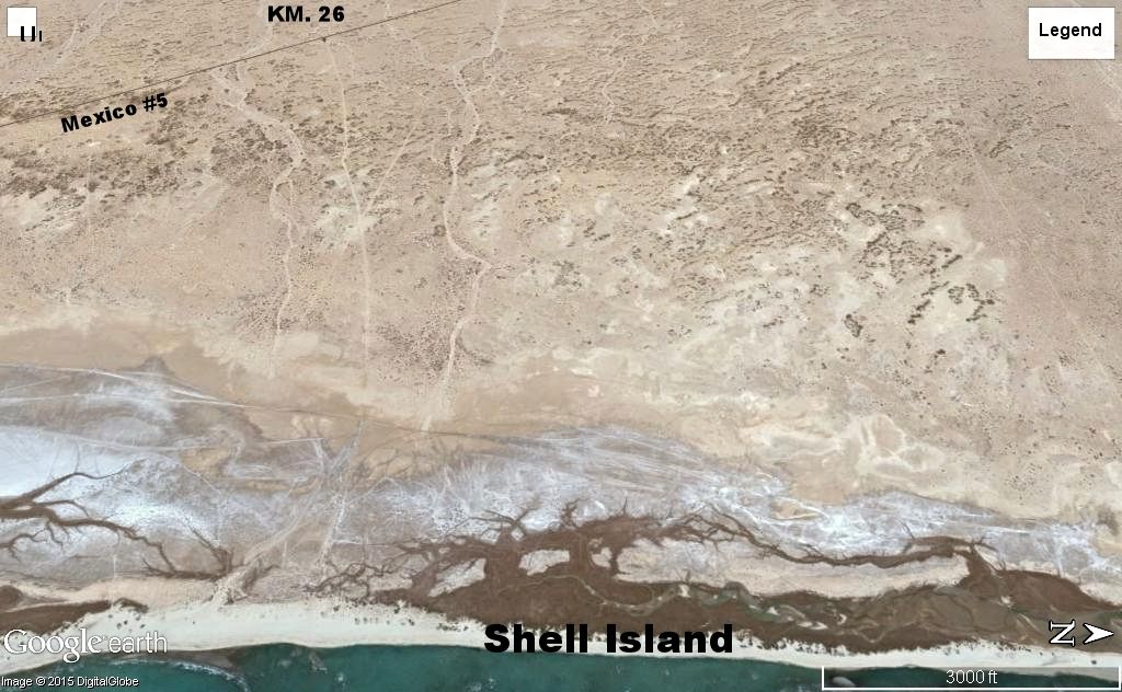
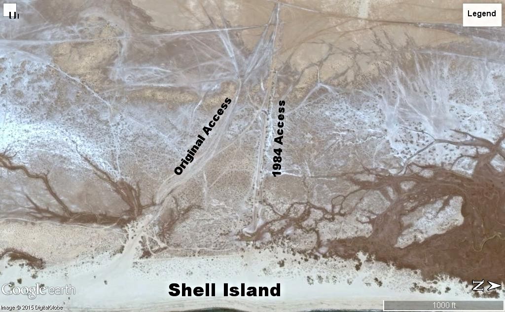
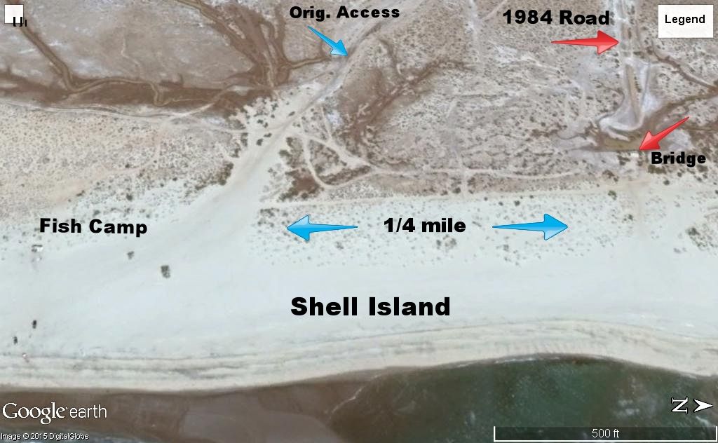
Check the tide chart for when you are going, and leaving... 18 ft. or higher high tide floods the salt flats behind Shell Island, connecting Laguna
Percebu on the north with Bahia Santa Maria on the south, and surrounds the island with water. If you arrive at high tide, drive in the well worn
track of the original road... it is compacted and thus lower, and thus deeper underwater, but has solid ground instead of 'oatmeal mush' to drive on.
[Edited on 5-5-2015 by David K]
|
|
|
David K
Honored Nomad
Posts: 64490
Registered: 8-30-2002
Location: San Diego County
Member Is Offline
Mood: Have Baja Fever
|
|
Here are the 2015 San Felipe Tide Calendars: http://sanfelipe.com.mx/weather/tide-calendars/
Not one tide higher than 18 feet in June, so the salt flats should be dry... Winds can change that... and there are two right at 18' (15th and 16th).
|
|
|
hayb
Junior Nomad
Posts: 59
Registered: 6-7-2012
Location: Ramona
Member Is Offline
|
|
David K,
We will arrive at high tide (15.3 ft) and stay two days passed the new moon (16.8). We always used the 1984 access entry. In 2012 I got stuck there
with fully loaded Dodge. It was like oatmeal mush, fully inflated tires didn't help. Thanks for the original access GE Map information. We will give
it a go on this trip.
|
|
|
PaulW
Ultra Nomad
Posts: 3009
Registered: 5-21-2013
Member Is Offline
|
|
We have used Km 26 for access.
I have never been brave enough to drive to the beach as we are just doing day trips. So we walk from high ground around/thru the mud to the dunes.
People driving to the beach obviously go a different way.
Paul
|
|
|
JohnK
Junior Nomad
Posts: 69
Registered: 3-11-2012
Member Is Offline
|
|
David: I think you're put it out there before, but do you have the lat long coordinates?
|
|
|
David K
Honored Nomad
Posts: 64490
Registered: 8-30-2002
Location: San Diego County
Member Is Offline
Mood: Have Baja Fever
|
|
For what point? Happy to help.
It is so long an island, it is easy to see on Google Earth, 20 miles south of San Felipe...
|
|
|
JohnK
Junior Nomad
Posts: 69
Registered: 3-11-2012
Member Is Offline
|
|
Maybe roughly where the old fish camp is? Just want to be sure. I think you can right click when pointing at it with Google satellite. Thanks, Dude!
|
|
|
PaulW
Ultra Nomad
Posts: 3009
Registered: 5-21-2013
Member Is Offline
|
|
Pretty close
K25.2 Shell Island=30° 46.793'N, 114° 44.177'W
Leading to 30° 46.558'N, 114° 42.329'W and 30° 46.361'N, 114° 42.310'W
K26 Shell Island = 30° 46.338'N, 114° 43.924'W
Leading to 30° 46.558'N, 114° 42.329'W and 30° 46.361'N, 114° 42.310'W
Coords are before the dunes where we usually park
Look on GE for more info
Paul
|
|
|
David K
Honored Nomad
Posts: 64490
Registered: 8-30-2002
Location: San Diego County
Member Is Offline
Mood: Have Baja Fever
|
|
Quote: Originally posted by JohnK  | | Maybe roughly where the old fish camp is? Just want to be sure. I think you can right click when pointing at it with Google satellite. Thanks, Dude!
|
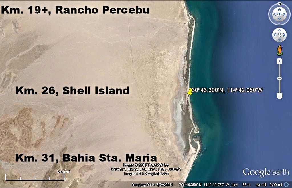
30º46.300'N, 114º42.050'W
|
|
|
JohnK
Junior Nomad
Posts: 69
Registered: 3-11-2012
Member Is Offline
|
|
What a resource you are, David. Thanks! - John
|
|
|
David K
Honored Nomad
Posts: 64490
Registered: 8-30-2002
Location: San Diego County
Member Is Offline
Mood: Have Baja Fever
|
|
Nice words John, very kind!
Baja has been so special to me and has given me so much fun and adventure the past 50 years (wow) since my first trip... I enjoy sharing and assisting
others, as a way to give back.
|
|
|
Elona
Junior Nomad
Posts: 71
Registered: 1-5-2015
Location: Germany
Member Is Offline
Mood: BC Addict
|
|
Now I'd like a drink from the Tiki Bar  . .
Saludos
Elona
 |
|
|
PaulW
Ultra Nomad
Posts: 3009
Registered: 5-21-2013
Member Is Offline
|
|
Anybody been to Campo Mayo? On Davids picture it is the large bay south of the Shell place. Access is from the south from Hermosa or S Maria.
I found the place name Mayo on GE?
Paul
|
|
|
deanfootlong
Junior Nomad
Posts: 53
Registered: 10-7-2013
Member Is Offline
|
|
just remember one thing when going through the 1984 access rd to get to shell island; when in doubt, floor it.

[Edited on 5-14-2015 by BajaNomad]
|
|
|
hayb
Junior Nomad
Posts: 59
Registered: 6-7-2012
Location: Ramona
Member Is Offline
|
|
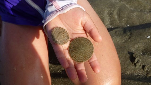
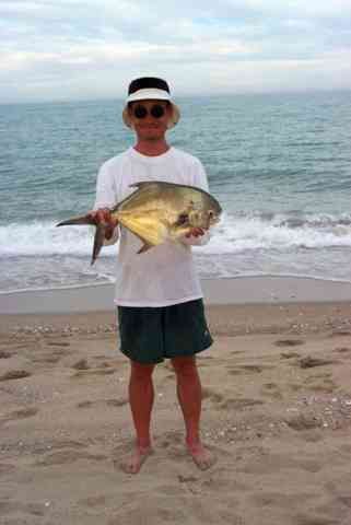
In 2002 I caught a permit at Shell Island.
|
|
|
Skipjack Joe
Elite Nomad
Posts: 8084
Registered: 7-12-2004
Location: Bahia Asuncion
Member Is Offline
|
|
If you can drive to 'Shell Island' then it's not an island. Islands don't disappear and reappear with the tides. There is no 'Shell Island'. It's all
Percebu Beach.
|
|
|
David K
Honored Nomad
Posts: 64490
Registered: 8-30-2002
Location: San Diego County
Member Is Offline
Mood: Have Baja Fever
|
|
LOL. The mud is not the island, it is where the sea water was at high tide which makes it an island. Not all places called islands are totally
surrouded either but this one actually is at highest tides. Percebu is three miles away from where that mud photo was taken. A failed campo about a
mile south of Percebu was named Isla San Martin, so I am not alone in calling this barrier island an island.
[Edited on 6-8-2015 by David K]
|
|
|
bajabuddha
Banned
Posts: 4024
Registered: 4-12-2013
Location: Baja New Mexico
Member Is Offline
Mood: Always cranky unless medicated
|
|
When an island is connected to shoreline by a sand spit or isthmus that covers at high tide with water, it is still technically an island, and the
umbilicus is called a "Tombolo".
http://en.wikipedia.org/wiki/Tombolo
Amazingly, Isla Requeson isn't listed in Wikipedia. Any Wiki members out there feel free to add it to their list. It's in the Roadside Geology book.
I believe he also mentions one down by La Paz.
I don't have a BUCKET LIST, but I do have a F***- IT LIST a mile long!
86 - 45*
|
|
|
David K
Honored Nomad
Posts: 64490
Registered: 8-30-2002
Location: San Diego County
Member Is Offline
Mood: Have Baja Fever
|
|
'Shell Tombolo' doesn't have the same sizzle... 
This is how National Geographic shows it (surrounded by water):
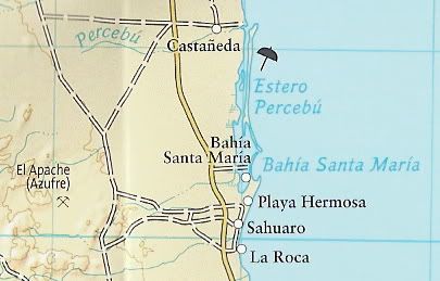
The pilot's aviation map, as well:
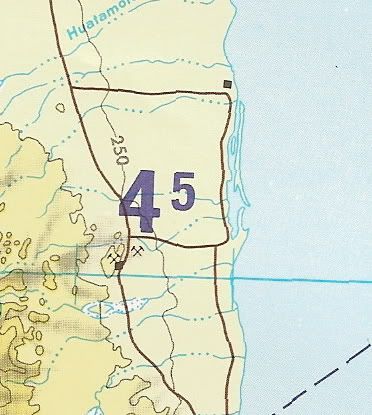
|
|
|
| Pages:
1
2
3
4
5 |