| Pages:
1
..
6
7
8
9
10
..
14 |
David K
Honored Nomad

Posts: 64545
Registered: 8-30-2002
Location: San Diego County
Member Is Offline
Mood: Have Baja Fever
|
|
Telling Secrets... hoping to find this before I die! LOL
OK, here is the wash I have the most confidence in being the one Henderson walked down to Arroyo Grande in... I call it 'B Wash'... after making a
list of possible westward flowing washes using letters. I drew a line over (not perfectly) the wash from the top to Arroyo Grande.
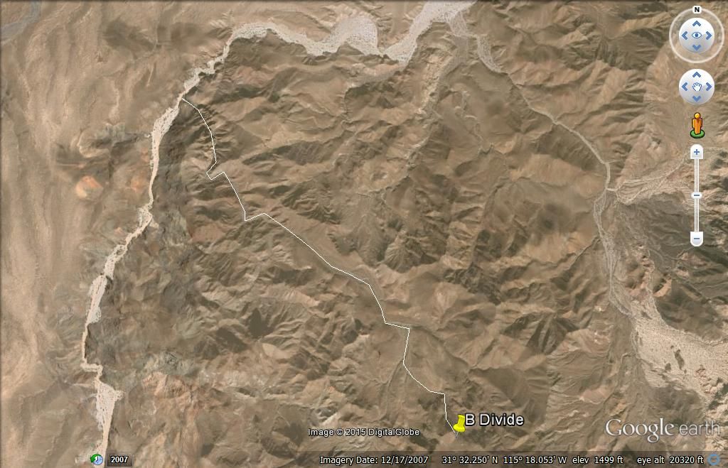
In Henderson's letter, he said they took the most obvious course to head NW towards the Sierra Tinajas, which was their target. They realized they
started too far south to hike there in the 2 day period they had to explore in. So After sleeping in Arroyo Grande the first night, they went south to
(what Henderson calls) the base of Borrego Mountain, then back over the saddle to the Model A (parked in Arroyo Arrajal at the entrance to the Sierra
Pinta hills).
Now, there is a clear description Henderson provides of where the rock-pile wash meets Arroyo Grande, and the B wash junction is the only one TW
didn't get a photo of, but even if he did, it may take a personal visit to see the detail? Perhaps landslides since the 1930's have destroyed the wall
he describes? Just a fun adventure... like our Santa Isabel Lost Mission hunt of 2011 in Arroyo el Volcan (thanks to elbeau).
|
|
|
Ken Cooke
Elite Nomad
Posts: 8923
Registered: 2-9-2004
Location: Riverside, CA
Member Is Offline
Mood: Its Pole Line Road time
|
|
Rio Hardy
MICK - If David K isnt able to attend our Pole Line Road trip, we would like to stay in luxury on the river one night. Maybe we could set up a
special trip in November to this region? David K would need to organize the routes.
|
|
|
David K
Honored Nomad
Posts: 64545
Registered: 8-30-2002
Location: San Diego County
Member Is Offline
Mood: Have Baja Fever
|
|
No organizing needed. The route is either down Arroyo Grande or up from Arroyo Arrajal from the race course crossing north of Borrego pit on Hwy. 3.
We know Arroyo Grade road is open now. Not known is how far up we can drive from Arrajal to the B Divide. Hiking in the desert to find a pile of rocks
is not fun for most. Mick, isn't one of the campgrounds open on Rio Hardy that Ken's city slickers can chill at if you won't be at your digs?
[Edited on 3-6-2015 by David K]
|
|
|
Ken Cooke
Elite Nomad
Posts: 8923
Registered: 2-9-2004
Location: Riverside, CA
Member Is Offline
Mood: Its Pole Line Road time
|
|
How about rentals in the Rio Hardy area??
|
|
|
MICK
Nomad
Posts: 499
Registered: 11-12-2003
Location: Rio Hardy
Member Is Offline
Mood: livin the good life on the river
|
|
No rentals I know of but your welcome to camp out here. We should be here around that time
Getting there is ALL the fun!
Ok being here is fun to
|
|
|
David K
Honored Nomad
Posts: 64545
Registered: 8-30-2002
Location: San Diego County
Member Is Offline
Mood: Have Baja Fever
|
|
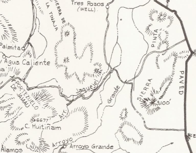
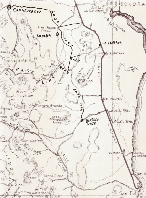
Back to the roots...
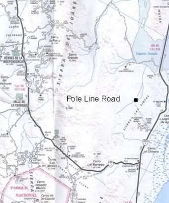
It was Neal Johns who got curious while reading the Lower California Guidebook...
Here is the page with the road from La Ventana on Hwy. 5, west to the Pole Line Road, then following it west to the summit:
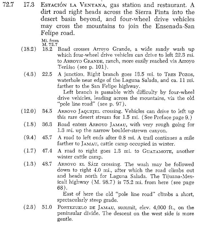
Here is the other part from the Ensenada-San Felipe Road (Hwy. 3 today) to the summit...
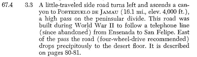
Map from La Ventana (the paved road and center dirt road junction) to the summit...
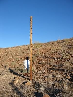
Ken Cooke at one of the World War II telephone poles...
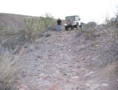
Ken Cooke on the WWII cobblestone road...
The Auto Club does not show the Pole Line Road!...
The black square is about were the wells (pumps) are.
[Edited on 3-11-2015 by David K]
|
|
|
PaulW
Ultra Nomad
Posts: 3022
Registered: 5-21-2013
Member Is Offline
|
|
Several GPS maps show a road that follows Jaquegel. Unreliable because the PLR enters and leaves the canyon. Also shown is access to Jaq from the
north at the east end of Jaq. Do know if that road is accurate?
|
|
|
TMW
Select Nomad
Posts: 10659
Registered: 9-1-2003
Location: Bakersfield, CA
Member Is Offline
|
|
Paul are you talking about the road from Saldana to Jaquegel? If so that is the way Ken normally has exited after his PLR runs. You can see it on page
4 of the almanac.
|
|
|
PaulW
Ultra Nomad
Posts: 3022
Registered: 5-21-2013
Member Is Offline
|
|
Quote: Originally posted by TMW  | | Paul are you talking about the road from Saldana to Jaquegel? If so that is the way Ken normally has exited after his PLR runs. You can see it on page
4 of the almanac. |
=
Yes, I am not familiar with that road. I should drive it. It is a short distance from Arroyo Grande to that Tee intersection that heads north. I just
drove past it on my last trip.
A friend said he has a track from the mine wells leading west to the subject road. Its on my to do list.
|
|
|
David K
Honored Nomad
Posts: 64545
Registered: 8-30-2002
Location: San Diego County
Member Is Offline
Mood: Have Baja Fever
|
|
| Quote: Originally posted by TMW | | Paul are you talking about the road from Saldana to Jaquegel? If so that is the way Ken normally has exited after his PLR runs. You can see it on page
4 of the almanac. |
Correct, but if you stayed on the Pole Line Road 4.3 more miles east to south, you would reach Arroyo Grande... from there you can drive north to the
wells, then easy out to Hwy. 5 by La Ventana... or south in Arroyo Grande... or cross over to the other side of Arroyo Grande to head towards San
Felipe on the Pole Line Road or to Borrego Wash on the race course.
Here is TW's map showing the T junction north via Saldana as well as Pole Line Road to Arroyo Grande then up to the wells, and out east to La
Ventana...
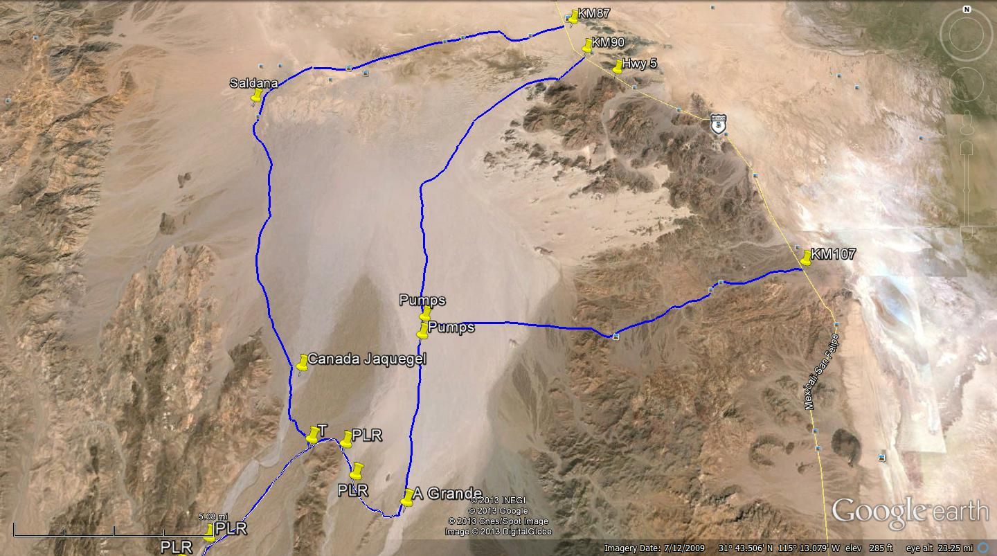
My maps with Pole Line Road route out to Hwy. 5...

|
|
|
PaulW
Ultra Nomad
Posts: 3022
Registered: 5-21-2013
Member Is Offline
|
|
David, Good mapping. What is missing is the track due west from the wells to the far west track from Saldana. That track crosses the Jaquegel drainage
and the guy said he got that track from a San Felipe old timer. He drove that track 2/2014 when his group did the PLR. Soon I will make contact and
get that track into my database.
PW
|
|
|
David K
Honored Nomad
Posts: 64545
Registered: 8-30-2002
Location: San Diego County
Member Is Offline
Mood: Have Baja Fever
|
|
| Quote: Originally posted by PaulW | David, Good mapping. What is missing is the track due west from the wells to the far west track from Saldana. That track crosses the Jaquegel drainage
and the guy said he got that track from a San Felipe old timer. He drove that track 2/2014 when his group did the PLR. Soon I will make contact and
get that track into my database.
PW |
Hi Paul,
I just searched the desert west of the wells on Bing and GE and can see no tracks crossing over to Jaquegel from Grande anywhere near the wells...? I
hope you can find it.
|
|
|
John M
Super Nomad
Posts: 1909
Registered: 9-3-2003
Location: California High Desert
Member Is Offline
|
|
TWO ADVENTURES?
So David - is this looking like two separate adventures? A pole line trip and an exploratory trip? Maybe the threads ought to each be on their own?
Pole Line is less than a month away and I'd like to see a thread (Ken) focusing on that trip - of course if it is one combined trip tnen I recant my
suggestion.
So Ken, Barb and I will be gone almost ten days, getting home one or two days before leaving for PLT - and we won't have internet most of the ten days
so maybe any details needed could be posted sooner rather than later?
John M
|
|
|
Ken Cooke
Elite Nomad
Posts: 8923
Registered: 2-9-2004
Location: Riverside, CA
Member Is Offline
Mood: Its Pole Line Road time
|
|
| Quote: Originally posted by John M | So David - is this looking like two separate adventures? A pole line trip and an exploratory trip? Maybe the threads ought to each be on their own?
Pole Line is less than a month away and I'd like to see a thread (Ken) focusing on that trip - of course if it is one combined trip tnen I recant my
suggestion.
So Ken, Barb and I will be gone almost ten days, getting home one or two days before leaving for PLT - and we won't have internet most of the ten days
so maybe any details needed could be posted sooner rather than later?
John M |
John -- Lets transition the planning of this trip to the following link:
http://forums.bajanomad.com/viewthread.php?tid=78026#pid9682...
Have a great time on your vacation. Please U2U me your current email address. My cell phone # is included in the thread if you need to reach me.
|
|
|
David K
Honored Nomad
Posts: 64545
Registered: 8-30-2002
Location: San Diego County
Member Is Offline
Mood: Have Baja Fever
|
|
Where the Pole Line Rd meets Arroyo Grande, I would be going south and those that aren't would drive north to the wells and out to Hwy. 5.
|
|
|
Ken Cooke
Elite Nomad
Posts: 8923
Registered: 2-9-2004
Location: Riverside, CA
Member Is Offline
Mood: Its Pole Line Road time
|
|
| Quote: Originally posted by David K | | Where the Pole Line Rd meets Arroyo Grande, I would be going south and those that aren't would drive north to the wells and out to Hwy. 5.
|
Gasoline would be a problem for the Jeeps. The run allows for a Jeep on 33" tires carrying an additional 10 gallons of fuel to run the Pole Line Road
and make it into South Mexicali before running out of gasoline. That is one area your Toyota's have us beat.
A more southern PEMEX was recently destroyed by the great Earthquakes that so decimated entire swaths of Mexicali turning many buildings there into
ruins.
[Edited on 3-13-2015 by Ken Cooke]
|
|
|
David K
Honored Nomad
Posts: 64545
Registered: 8-30-2002
Location: San Diego County
Member Is Offline
Mood: Have Baja Fever
|
|
Where are you leaving PLR, at the T junction and up through Saldana?
The Arroyo Grande wash is just 4.3 miles further.
At that point you can drive the 6 or so miles north to the wells, then the fast 12 mile graded road to La Ventana on Hwy. 5... Overall, fewer dirt
miles, more highway miles and less gas needed to Mexicali.
|
|
|
Ken Cooke
Elite Nomad
Posts: 8923
Registered: 2-9-2004
Location: Riverside, CA
Member Is Offline
Mood: Its Pole Line Road time
|
|
| Quote: Originally posted by David K | Where are you leaving PLR, at the T junction and up through Saldana?
The Arroyo Grande wash is just 4.3 miles further.
At that point you can drive the 6 or so miles north to the wells, then the fast 12 mile graded road to La Ventana on Hwy. 5... Overall, fewer dirt
miles, more highway miles and less gas needed to Mexicali. |
Traveling north to the area you described is along the way towards Mexicali. One consideration will need to be running out of daylight on Day#2. I
will want to return to Mexicali on Monday morning before mid day. It was about 90 degrees on Saturday near the Salton Sea.
|
|
|
David K
Honored Nomad
Posts: 64545
Registered: 8-30-2002
Location: San Diego County
Member Is Offline
Mood: Have Baja Fever
|
|
The gas station at La Puerta on Hwy. 5 is also 15 miles closer, than any near Mexicali.
So either you hit Hwy. 5 at La Ventana (shorter, less dirt road) via Arroyo Grande and the well road or you go further north in dirt via Saldana to
the sand dunes at Hwy. 5... you still drive north on Hwy. 5 to La Puerta Pemex.
Are you still camping Sunday night at Rio Hardy, south of La Puerta?
[Edited on 3-13-2015 by David K]
|
|
|
PaulW
Ultra Nomad
Posts: 3022
Registered: 5-21-2013
Member Is Offline
|
|
David Wrote:
..... There was a steel cable blocking the way back in 2012 when I last tried to drive up.... [/rquote]
=====
I saw the cable in the Jan 2012 time frame. No issue it was sticking up about a foot and I drove parallel to it and found it buried and then
continued south. That trip I found it when I crossed from the SCORE road to AG. This would be on the far east of the AG wash. Since then I have not
seen the cable in that specific area. Now days to get into AG canyon or even to PLR access we travel on the west side of AG when the race whoops
start. This is for access from the wells driving south.
Anyway, when leaving the PLR to enter AG travel N or S and you will not see the cable.
My suspicion was that back in the 70s SCORE used AG and that is when the cable was added. I still have not found and records to document this. Old
SCORE was not aware of the cable.
|
|
|
| Pages:
1
..
6
7
8
9
10
..
14 |


