| Pages:
1
..
9
10
11
12
13
14 |
David K
Honored Nomad

Posts: 64490
Registered: 8-30-2002
Location: San Diego County
Member Is Offline
Mood: Have Baja Fever
|
|
Oh, I can boil water!  
These backpacker meals are great and easy!  
|
|
|
4x4abc
Ultra Nomad
Posts: 4165
Registered: 4-24-2009
Location: La Paz, BCS
Member Is Offline
Mood: happy - always
|
|
Cohabuzo Junction it will be
haven't been on the pole line road for 15 years
where is basketball hill?
Harald Pietschmann
|
|
|
Ken Cooke
Elite Nomad
Posts: 8921
Registered: 2-9-2004
Location: Riverside, CA
Member Is Offline
Mood: Black Trans Lives Matter
|
|
20-30 miles?
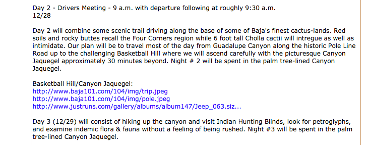
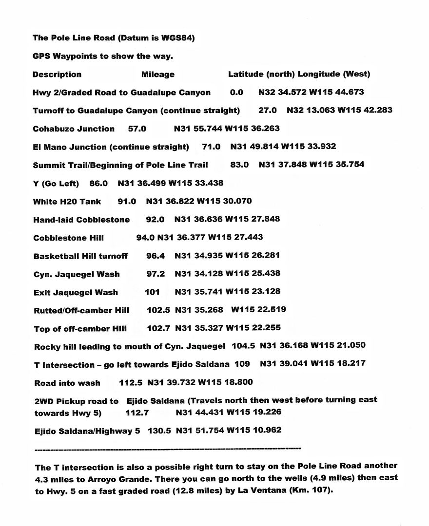
Quote: Originally posted by David K  | The Pole Line Group is traveling south from Hwy. 2 at Laguna Salada, past Cohabuzo Jcn. to the base of the old summit (Jamau) road (Pole Line Road)
and joining it going from WEST to EAST.
Saturday Night we will be in the middle of the 20-30 mile WWII road run. |
Mile 1 - Hwy 2/Laguna Salada
Mile 57 - COHABUZO JUNCTION (from Hwy 2)
Mile 83.5 - Gated entrance to Pole Line Road
Mile 96.4 - Basketball Hill
Mile 102.7 - Top of "Bad Hill"
Mile 124.3 - "Y", Go left, east, slightly downhill for El Chinero on Hwy 5 or go right, south, to Hwy. 3.
Mile 130.5 - Hwy 5 a few miles north of Hwy. 5/3 Junction
Although, these mileage numbers seem meager, they consume gallons of gasoline and from Progreso, Mexicali to the Rio Hardy area, consume 29 gallons in
our Jeeps. Be sure to arrive prepared with plenty of fuel.
|
|
|
David K
Honored Nomad
Posts: 64490
Registered: 8-30-2002
Location: San Diego County
Member Is Offline
Mood: Have Baja Fever
|
|
| Quote: Originally posted by 4x4abc | Cohabuzo Junction it will be
haven't been on the pole line road for 15 years
where is basketball hill? |
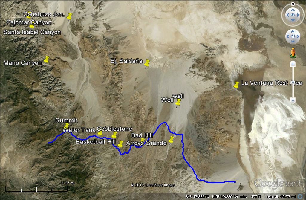
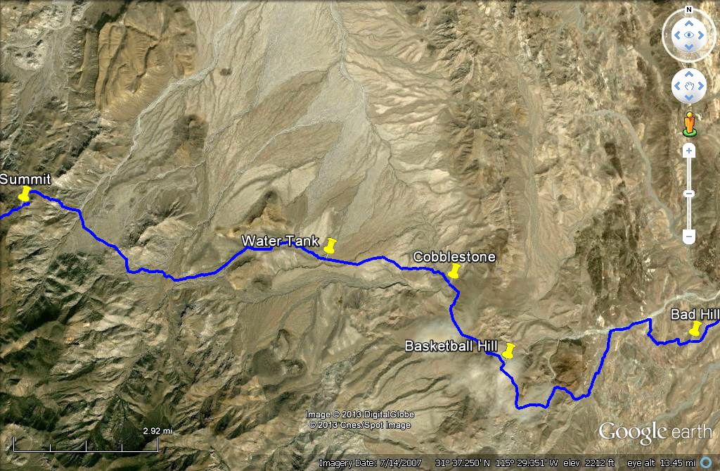
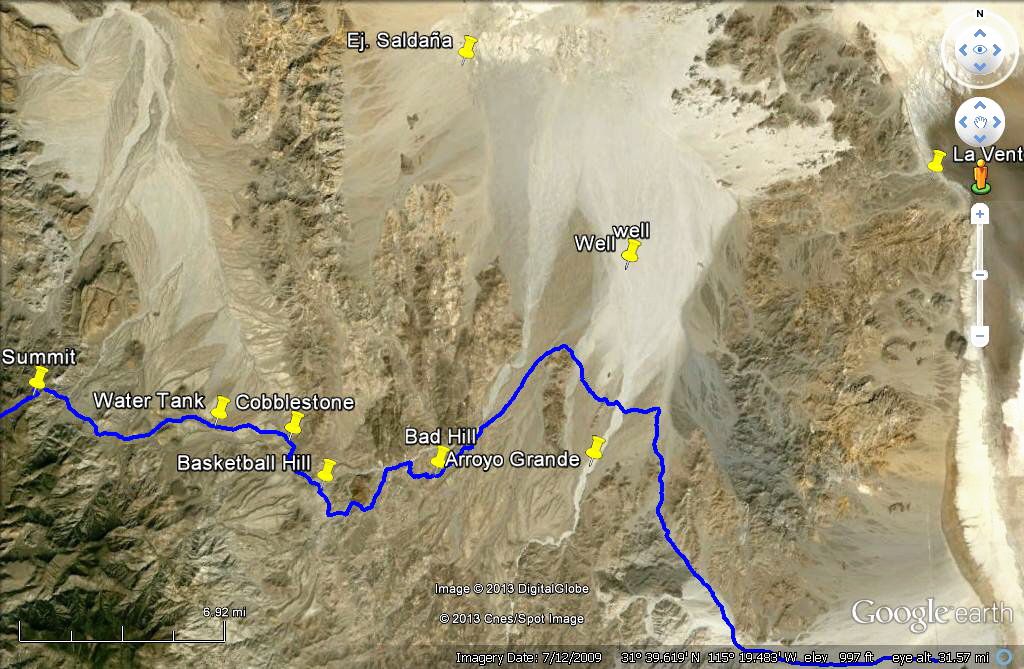
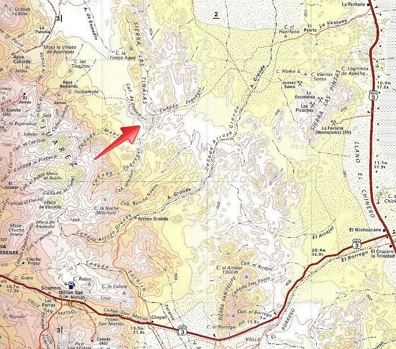
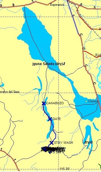
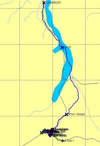
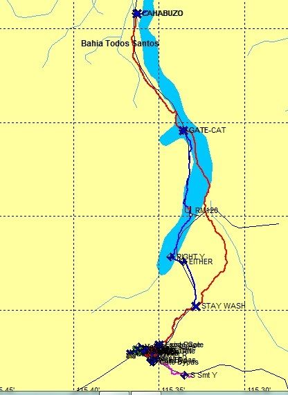
Middle of the run... overall area incl. Cohabuzo Jcn. and Basketball Hill... Pole Line Road is blue line:
Close Up West Half:
East Half:
|
|
|
4x4abc
Ultra Nomad
Posts: 4165
Registered: 4-24-2009
Location: La Paz, BCS
Member Is Offline
Mood: happy - always
|
|
so I am googling basketball hill
find some of my own images
find that it is linked to the Nomad site
what a surprise!
looks like someone "borrowed" images from my site

Harald Pietschmann
|
|
|
David K
Honored Nomad
Posts: 64490
Registered: 8-30-2002
Location: San Diego County
Member Is Offline
Mood: Have Baja Fever
|
|
20-30 miles?
| Quote: Originally posted by Ken Cooke | | Quote: Originally posted by David K | The Pole Line Group is traveling south from Hwy. 2 at Laguna Salada, past Cohabuzo Jcn. to the base of the old summit (Jamau) road (Pole Line Road)
and joining it going from WEST to EAST.
Saturday Night we will be in the middle of the 20-30 mile WWII road run. |
Mile 1 - Hwy 2/Laguna Salada
Mile 57 - COHABUZO JUNCTION (from Hwy 2)
Mile 83.5 - Gated entrance to Pole Line Road
Mile 96.4 - Basketball Hill
Mile 102.7 - Top of "Bad Hill"
Mile 124.3 - "Y", Go left, east, slightly downhill for El Chinero on Hwy 5 or go right, south, to Hwy. 3.
Mile 130.5 - Hwy 5 a few miles north of Hwy. 5/3 Junction
Although, these mileage numbers seem meager, they consume gallons of gasoline and from Progreso, Mexicali to the Rio Hardy area, consume 29 gallons in
our Jeeps. Be sure to arrive prepared with plenty of fuel. |
You aren't on the Pole Line Road until Mile 83.5... and you are leaving it at the T Junction (Mile 109) or Arroyo Grande (Mile 113)... that's 26-30
miles.
[Edited on 3-29-2015 by David K]
|
|
|
David K
Honored Nomad
Posts: 64490
Registered: 8-30-2002
Location: San Diego County
Member Is Offline
Mood: Have Baja Fever
|
|
Harald, here are the GPS and mile markers on the run...
Approx. location of Basketball Hill... red arrow...
[Edited on 3-29-2015 by David K]
|
|
|
Ken Cooke
Elite Nomad
Posts: 8921
Registered: 2-9-2004
Location: Riverside, CA
Member Is Offline
Mood: Black Trans Lives Matter
|
|
$160 USD fine for use of my Pro-Comp tow rope
| Quote: Originally posted by David K | | Quote: Originally posted by Ken Cooke | | Quote: Originally posted by David K | The Pole Line Group is traveling south from Hwy. 2 at Laguna Salada, past Cohabuzo Jcn. to the base of the old summit (Jamau) road (Pole Line Road)
and joining it going from WEST to EAST.
Saturday Night we will be in the middle of the 20-30 mile WWII road run. |
Mile 1 - Hwy 2/Laguna Salada
Mile 57 - COHABUZO JUNCTION (from Hwy 2)
Mile 83.5 - Gated entrance to Pole Line Road
Mile 96.4 - Basketball Hill
Mile 102.7 - Top of "Bad Hill"
Mile 124.3 - "Y", Go left, east, slightly downhill for El Chinero on Hwy 5 or go right, south, to Hwy. 3.
Mile 130.5 - Hwy 5 a few miles north of Hwy. 5/3 Junction
Although, these mileage numbers seem meager, they consume gallons of gasoline and from Progreso, Mexicali to the Rio Hardy area, consume 29 gallons in
our Jeeps. Be sure to arrive prepared with plenty of fuel. |
You aren't on the Pole Line Road until Mile 83.5... and you are leaving it at the T Junction (Mile 109) or Arroyo Grande (Mile 113)... that's 26-30
miles.
[Edited on 3-29-2015 by David K] |
I had to pull a Jeep up the Mission Impossible waterfall. Nope, it wasn't much fun (on 3 wheels). If a rig runs out of gas, I know those Tacomas are
more stable tow vehicles.
|
|
|
David K
Honored Nomad
Posts: 64490
Registered: 8-30-2002
Location: San Diego County
Member Is Offline
Mood: Have Baja Fever
|
|
I have a Dick Cepek Baja Proven Tow Strap in my truck storage compartment, used many times to pull lesser vehicles out of trouble... no charge, no
fine, just strong words about what vehicle should be in your corral instead!

|
|
|
MICK
Nomad
Posts: 499
Registered: 11-12-2003
Location: Rio Hardy
Member Is Offline
Mood: livin the good life on the river
|
|
Just a reminder that you can not go across the border with you gas cans full. all gas cans MUST be empty. They will turn you around and they will
check. For some reason this is the only border rules that they always seem to follow.
Getting there is ALL the fun!
Ok being here is fun to
|
|
|
Ken Cooke
Elite Nomad
Posts: 8921
Registered: 2-9-2004
Location: Riverside, CA
Member Is Offline
Mood: Black Trans Lives Matter
|
|
| Quote: Originally posted by MICK | | Just a reminder that you can not go across the border with you gas cans full. all gas cans MUST be empty. They will turn you around and they will
check. For some reason this is the only border rules that they always seem to follow. |
Thank you for this timely information, MICK. Also on the FMM papers. You are right. Too many crowds, too many people = way too much paperwork.
|
|
|
PaulW
Ultra Nomad
Posts: 3009
Registered: 5-21-2013
Member Is Offline
|
|
The route Ken described 3/29 from hwy 2 to the north side of the summit to get to the PLR gate area.
1) Overview Route from Hwy 2 to PLR gates mostly via wash at S end
2) View from Cohabuzo to PLR gates. We stopped using the W loop and the last few years stayed in the wash heading N because the W loop is so very
rough. Both ways will work.
3) This pic is an updated version of a previous post for the Gate area. Hopefully more clear now. The new race road turns slightly SW at the fence
gate.
Your route would pass thru the fence gate in the wash then pass the locked gate and go S by SW. Soon it turns right at the T shown to get on the
traditional PLR then head SE.
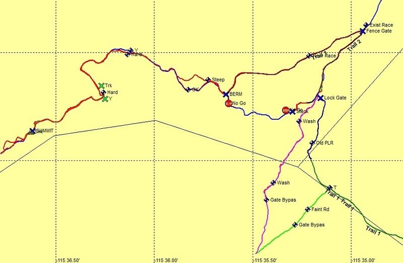
[Edited on 3-31-2015 by PaulW]
|
|
|
Ken Cooke
Elite Nomad
Posts: 8921
Registered: 2-9-2004
Location: Riverside, CA
Member Is Offline
Mood: Black Trans Lives Matter
|
|
Hi Paul,
Once again, Thank you for providing so much information on this area. Do you have photographs of the berms and the 'no go's' in this area? No
go-arounds? When you say, 'rough', how bad going did it all appear?
This may take us a few hours (or more) to locate adequate routes that you have mentioned.
|
|
|
PaulW
Ultra Nomad
Posts: 3009
Registered: 5-21-2013
Member Is Offline
|
|
| Quote: Originally posted by Ken Cooke | Hi Paul,
Once again, Thank you for providing so much information on this area. Do you have photographs of the berms and the 'no go's' in this area? No
go-arounds? When you say, 'rough', how bad going did it all appear?
This may take us a few hours (or more) to locate adequate routes that you have mentioned. |
=========
No Pics even tho I have done the trip from the summit at least 10 times. Got lots of gps tracks. Anyway the so called loop road the drifts west of the
so called wash track is strewn with boulders and is rough compared to driving in the sand wash. The WP called stay wash is the jct of the two that
we needed marked when traveling north due to a 270 deg turn. The racers for all classes used that loop many times and they abandoned it due to all
the complaints and SCORE sent one of the guys down the wash and found it was OK. None of you guys will have any problem with either option. Just use
low range and keep the revs up. Normal sand driving. I think the loop will be somewhat slower.
The berm at the no go is not very significant. I think I said it was a feeble attempt to close that track. I so labeled for the race guys I gave the
GPS file to. They always come down from the summit and it would not be good if they went over that berm because they would first come to a locked
fence gate then the washouts below. We passed that locked fence gate by unwiring the fence and proceeded up to the berm when we drove that track in
Jan 2014 with no clue that there was a new track made for the race. Remember the 250 race when the summit was closed off. They made that new road and
did not use it. The no Go is my new name because I fell into the washout on my right side. High centered and everyone pitched in for about 45
minutes and piled rocks so I could back out. The reason I fell in was the off camber washout and was to narrow and my right side wheels slipped into
the washout. It was a little over 3' deep. There is a go around to the S of that track where I got stuck, but I walked to it and it was almost as bad.
Then one of the guys said the road is over there on the ridge. So we sent the tail gunner back to see if he could find it and sure enough it is the
track I labeled New Race (note the over write of Trail 1).
Here are the two tracks we are discussing. The rough one is on the west side and the one on the right is mostly sand wash.
I sent the Google Earth and GPS tracks to Tom (TMW) and Edward Hall (ehall). Maybe they can forward the GPS files to the guys on the trip that have
the units.
Waypoints are from SCORE for a vehicle travelling to Cahobozo
Paul
[Edited on 3-31-2015 by PaulW]
|
|
|
David K
Honored Nomad
Posts: 64490
Registered: 8-30-2002
Location: San Diego County
Member Is Offline
Mood: Have Baja Fever
|
|
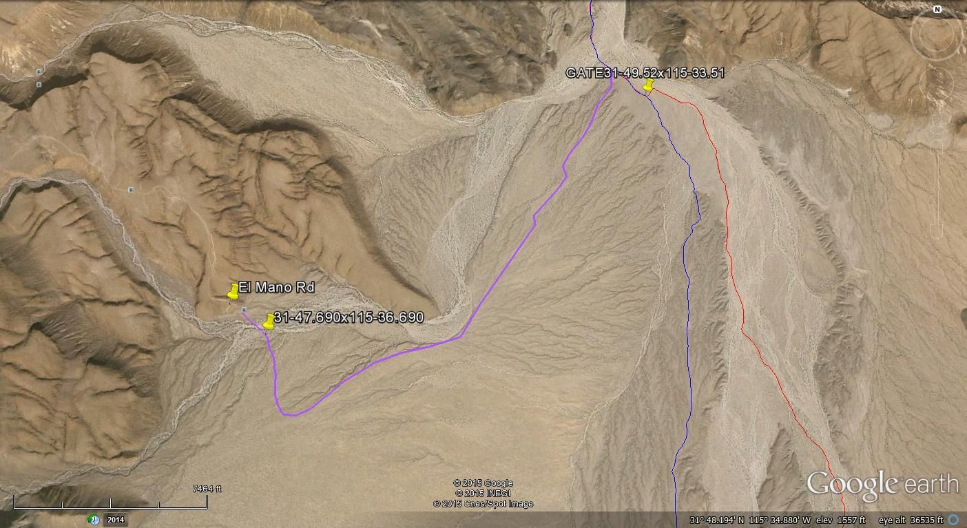
How far south of Cohabuzo Jcn. is the Mano Canyon Road Jcn., do you have the waypoint for it.
I recall it was in a big sandy wash back in 2003.
|
|
|
bajatrailrider
Super Nomad
Posts: 2423
Registered: 1-24-2015
Location: Mexico
Member Is Offline
Mood: Happy
|
|
David K speaking of Mano canyon Road.Another member asked me.When I meet you (but I will forget) The Governors Mansion,pool of water near El Mano is
this route doable with 4x4.Cool place to see?
|
|
|
TMW
Select Nomad
Posts: 10659
Registered: 9-1-2003
Location: Bakersfield, CA
Member Is Offline
|
|
Here is a GE view of the routes from the gate that Paul showed and a route to El Mano road. The one to the left.
|
|
|
MICK
Nomad
Posts: 499
Registered: 11-12-2003
Location: Rio Hardy
Member Is Offline
Mood: livin the good life on the river
|
|
So the river is running full between here and Laguna salada because of the full moon. So I am either going to head north and meet you guys at the
entrance to LS or head south and go in at tres posas and met still at cabuzo jct. anyone else heading in from the south?
Mick
Getting there is ALL the fun!
Ok being here is fun to
|
|
|
4x4abc
Ultra Nomad
Posts: 4165
Registered: 4-24-2009
Location: La Paz, BCS
Member Is Offline
Mood: happy - always
|
|
| Quote: Originally posted by MICK | So the river is running full between here and Laguna salada because of the full moon. So I am either going to head north and meet you guys at the
entrance to LS or head south and go in at tres posas and met still at cabuzo jct. anyone else heading in from the south?
Mick
|
Mick,
I am coming up from La Paz. Will set up my sun shade at Cohabuzo Junction for a (kinda) noon meeting.
Harald Pietschmann
|
|
|
4x4abc
Ultra Nomad
Posts: 4165
Registered: 4-24-2009
Location: La Paz, BCS
Member Is Offline
Mood: happy - always
|
|
I need your help guys - if you have a supermarket nearby selling Western Family articles, I need some cans.
I need:
http://westernfamily.com/products/premium-hot-chili-con-carn...
Desperately need them for my beans mix - so, can someone please get 10 cans?
Karl tried in Los Angles, but had no luck.
Harald Pietschmann
|
|
|
| Pages:
1
..
9
10
11
12
13
14 |


