| Pages:
1
..
7
8
9
10
11
..
14 |
David K
Honored Nomad

Posts: 64526
Registered: 8-30-2002
Location: San Diego County
Member Is Offline
Mood: Have Baja Fever
|
|
Thanks Paul, yes people have driven up (south) AG from the PLR in years past (Neal Johns, etc.) and I knew the 2012 cable was gone because others (TW,
etc.) have been up (south) AG since.
Rather Ken and the Jeep people head to Rio Hardy from the T Junction or the Arroyo Grande junction, I hope to drive up AG to 'Wash B' and take a 2-3
mile hike, and look for a pile of rocks. If others (John M, etc.) want to join me, terrific!
Rather we find it or not, I know Choral Pepper will be smiling down upon us, as she did when I found her mystery walls/ lost mission back in 2009....
http://vivabaja.com/109
|
|
|
TMW
Select Nomad
Posts: 10659
Registered: 9-1-2003
Location: Bakersfield, CA
Member Is Offline
|
|
If things workout I hope to join DK.
|
|
|
David K
Honored Nomad
Posts: 64526
Registered: 8-30-2002
Location: San Diego County
Member Is Offline
Mood: Have Baja Fever
|
|
OK, that helps to know... joining me after Ken's Pole Line Road run:
John M
TMW
PaulW (yes?)
This would be Sunday afternoon we go to the Arroyo B junction with Arroyo Grande... GPS (WGS84) in decimal degrees:
31.54925, -115.31957 OR in decimal minutes: 31 degrees 32.955'N 115 degrees 19.174'W
If we discover that is not a possible wash, due to waterfalls. cliffs, etc. not matching the Henderson letter, there is a second good wash, Arroyo A:
31.524526, -115.32323 OR 31 degrees 31.454'N, 115 degrees 19.408'W
The hike would probably be Monday morning, 4 hours (in and out) so we could be done by noon... naturally, it is Baja, and I am flexible and this is in
good fun as our Santa Isabel lost mission hike was in 2011.
Lots of water, snake bite kit, cameras, GPS are what we need to enjoy and record the discovery.
The map below shows A, B and a C arroyo. B has the best odds for walking from the Model A as a natural path up and over the divide, I think. Arroyo A
was my second choice. Arroyo C I have dismissed, too far north.
Sites A and B are just in the wash up the canyons, and not more than that. Henderson said the rock pile was 1/4 to 1/3 down the wash from the divide
towards Arroyo Grande.
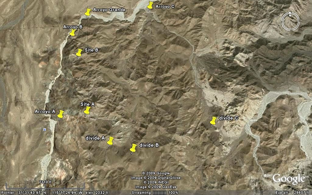
If it is the 1541 grave of Melchior Diaz, it would change popular historic thought on his expedition and prove him to be the first European to walk
into California.
[Edited on 3-13-2015 by David K]
|
|
|
PaulW
Ultra Nomad
Posts: 3015
Registered: 5-21-2013
Member Is Offline
|
|
Quote: Originally posted by David K  | OK, that helps to know... joining me after Ken's Pole Line Road run:
John M
TMW
PaulW (yes?)
==
Not PaulW during Easter weekend.
To many conflicts at our end. We will be in Moab by then.
Back in Baja on October to follow up.
Doing PLR the week of the 3/23 with local guys. Going E to W
Another AG trip is still in the cards before we head north?
PW
[Edited on 3-13-2015 by PaulW] |
|
|
|
David K
Honored Nomad
Posts: 64526
Registered: 8-30-2002
Location: San Diego County
Member Is Offline
Mood: Have Baja Fever
|
|
Bummer, I would like to meet you... next time perhaps?
|
|
|
John M
Super Nomad
Posts: 1908
Registered: 9-3-2003
Location: California High Desert
Member Is Offline
|
|
GPS stuff David
Hey David - I notice on the google earth map you posted it displays Degrees, Minutes, Seconds whereas in your message you are using Decimal Degrees.
Most everything else, all my maps, most all guide books and I think the waypoints Paul has sent is in the more common Degree, Decimal Minutes.
My suggestion is to pick one format for everything - I suggest Degree, Decimal minutes.
John
|
|
|
David K
Honored Nomad
Posts: 64526
Registered: 8-30-2002
Location: San Diego County
Member Is Offline
Mood: Have Baja Fever
|
|
| Quote: Originally posted by John M | Hey David - I notice on the google earth map you posted it displays Degrees, Minutes, Seconds whereas in your message you are using Decimal Degrees.
Most everything else, all my maps, most all guide books and I think the waypoints Paul has sent is in the more common Degree, Decimal Minutes.
My suggestion is to pick one format for everything - I suggest Degree, Decimal minutes.
John |
I was on FlashEarth (which uses newer Bing images of Baja): http://www.flashearth.com/
It only offers decimal degrees, and like you I usually post with decimal minutes, as in Geocaching.
However changing to decimal degrees (or other formats) on Google Earth is easy!!!
Here are the steps:
TOP OF PAGE:
Click TOOLS
Click OPTIONS
(it should be right there on the 3D View menu)
Second box down, says 'Show Lat/Lon' ... choose decimal degrees (top choice)
CLICK OK!
|
|
|
TMW
Select Nomad
Posts: 10659
Registered: 9-1-2003
Location: Bakersfield, CA
Member Is Offline
|
|
David that is odd because when I'm on it, it shows Hr-Min-Sec.
|
|
|
David K
Honored Nomad
Posts: 64526
Registered: 8-30-2002
Location: San Diego County
Member Is Offline
Mood: Have Baja Fever
|
|
John, I edited the post to include decimal minutes... because the new Nomad software still doesn't like degree symbols, I wrote the word degrees in
that place.
|
|
|
PaulW
Ultra Nomad
Posts: 3015
Registered: 5-21-2013
Member Is Offline
|
|
Bing is difficult
Good pictures and no help.
I was driven to deg and decimal minutes in order to plot on the Topos deg and I will stay with decimal minutes to make as easy as possible.
So what I do is take coords off my desktop GPS and plot them on the topos or enter on GE set for the same for viewing there.
PW
[Edited on 3-13-2015 by PaulW]
|
|
|
David K
Honored Nomad
Posts: 64526
Registered: 8-30-2002
Location: San Diego County
Member Is Offline
Mood: Have Baja Fever
|
|
On FlashEarth? Interesting, I never saw or touched a setting choice.
Oh guess what?! When you click your mouse on the lon and lat numbers on FlashEarth, it switches between decimal degrees and degrees, minutes and
seconds (no decimal minutes). 
[Edited on 3-13-2015 by David K]
|
|
|
David K
Honored Nomad
Posts: 64526
Registered: 8-30-2002
Location: San Diego County
Member Is Offline
Mood: Have Baja Fever
|
|
I just measured the distance in Arroyo Grande from Arroyo B to Arroyo A and it is 2.0 miles. In fact, one could do a full circle as the top (divide)
for A and B are almost next to each other... up one and down the other.
|
|
|
PaulW
Ultra Nomad
Posts: 3015
Registered: 5-21-2013
Member Is Offline
|
|
| Quote: Originally posted by David K | | John, I edited the post to include decimal minutes... because the new Nomad software still doesn't like degree symbols, I wrote the word degrees in
that place. |
======
Best to show both. Degrees are as hard to plot as deg,min,sec
|
|
|
PaulW
Ultra Nomad
Posts: 3015
Registered: 5-21-2013
Member Is Offline
|
|
So C is toms T4, B is S of T6 and A must be T7 or 8
I think I have lost track?
My GPS track is done and uses T designation
Confirm and I will change my GPS.
|
|
|
David K
Honored Nomad
Posts: 64526
Registered: 8-30-2002
Location: San Diego County
Member Is Offline
Mood: Have Baja Fever
|
|
I think it's time to start a new thread 2015 Hike for Henderson?
Here it is, maps included... http://forums.bajanomad.com/viewthread.php?tid=78057
[Edited on 3-14-2015 by David K]
|
|
|
Ken Cooke
Elite Nomad
Posts: 8922
Registered: 2-9-2004
Location: Riverside, CA
Member Is Offline
Mood: Its Pole Line Road time
|
|
| Quote: Originally posted by PaulW | | Quote: Originally posted by David K | OK, that helps to know... joining me after Ken's Pole Line Road run:
John M
TMW
PaulW (yes?)
==
Not PaulW during Easter weekend.
To many conflicts at our end. We will be in Moab by then.
Back in Baja on October to follow up.
Doing PLR the week of the 3/23 with local guys. Going E to W
Another AG trip is still in the cards before we head north?
PW
[Edited on 3-13-2015 by PaulW] |
Sorry you can't make my run, Paul. U2U me a mailing address for your Pole Line t-shirts, and I'll see you on the next run. |
|
|
|
Ken Cooke
Elite Nomad
Posts: 8922
Registered: 2-9-2004
Location: Riverside, CA
Member Is Offline
Mood: Its Pole Line Road time
|
|
| Quote: Originally posted by David K | The gas station at La Puerta on Hwy. 5 is also 15 miles closer, than any near Mexicali.
So either you hit Hwy. 5 at La Ventana (shorter, less dirt road) via Arroyo Grande and the well road or you go further north in dirt via Saldana to
the sand dunes at Hwy. 5... you still drive north on Hwy. 5 to La Puerta Pemex.
Are you still camping Sunday night at Rio Hardy, south of La Puerta?
[Edited on 3-13-2015 by David K] |
La Puerto es finito. The closest Pemex station is either in Ejido Durango or along Hwy 5 where the Toll Road intersects with it.
As for Rio Hardy - MICK has been real gracious to let us stay there. I have to see the day of the run during our drivers meeting what everyone agrees
to.
|
|
|
Ken Cooke
Elite Nomad
Posts: 8922
Registered: 2-9-2004
Location: Riverside, CA
Member Is Offline
Mood: Its Pole Line Road time
|
|
| Quote: Originally posted by David K | | Quote: Originally posted by Ken Cooke | | Quote: Originally posted by David K | The gas station at La Puerta on Hwy. 5 is also 15 miles closer, than any near Mexicali.
So either you hit Hwy. 5 at La Ventana (shorter, less dirt road) via Arroyo Grande and the well road or you go further north in dirt via Saldana to
the sand dunes at Hwy. 5... you still drive north on Hwy. 5 to La Puerta Pemex.
Are you still camping Sunday night at Rio Hardy, south of La Puerta?
[Edited on 3-13-2015 by David K] |
La Puerto es finito. The closest Pemex station is either in Ejido Durango or along Hwy 5 where the Toll Road intersects with it.
As for Rio Hardy - MICK has been real gracious to let us stay there. I have to see the day of the run during our drivers meeting what everyone agrees
to. |
Seriously??? It was a huge and busy place last year...??? La Puerta, about 25 miles south of the border. |
I'm refering to the smaller place that only had 4 pumps that looked like it was constructed in the 1950s. I have photographs taken there, at night.
So, you can't make out the building too well.
|
|
|
David K
Honored Nomad
Posts: 64526
Registered: 8-30-2002
Location: San Diego County
Member Is Offline
Mood: Have Baja Fever
|
|
The town had only one station, on the west side, north end of town... always busy. Perhaps the San Felipe regulars can confirm if it is open?
[Edited on 3-15-2015 by David K]
|
|
|
MICK
Nomad
Posts: 499
Registered: 11-12-2003
Location: Rio Hardy
Member Is Offline
Mood: livin the good life on the river
|
|
The gas station in La Puerta is still open. Got gas there two days ago.
Getting there is ALL the fun!
Ok being here is fun to
|
|
|
| Pages:
1
..
7
8
9
10
11
..
14 |


