| Pages:
1
2 |
David K
Honored Nomad

Posts: 64480
Registered: 8-30-2002
Location: San Diego County
Member Is Offline
Mood: Have Baja Fever
|
|
AAA Baja Map (Auto Club of So Cal Baja Map) is HISTORY + San Felipe area old maps
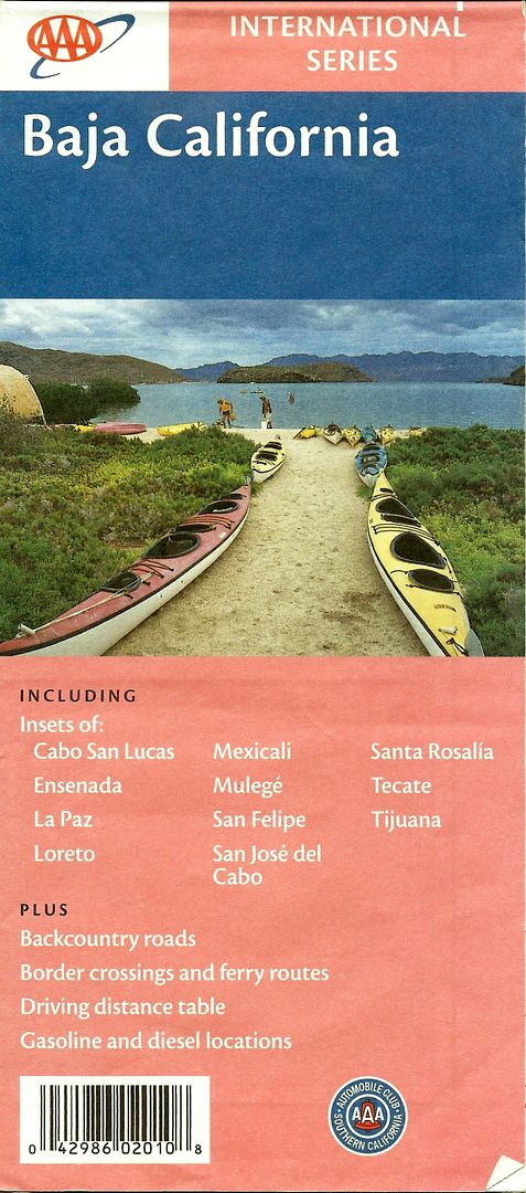
We have been told, so it is not a surprise... the cartographers were all let go... as was the travel guide writer, some years ago... but they were
reprinting the last revised edition (2003) in 2004, 2007, and 2010.
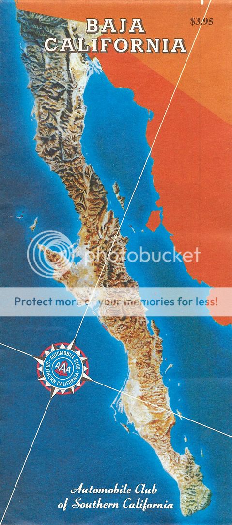
From 1975-2000 the map cover looked about the same, with the full color terrain map of Baja...
1996:
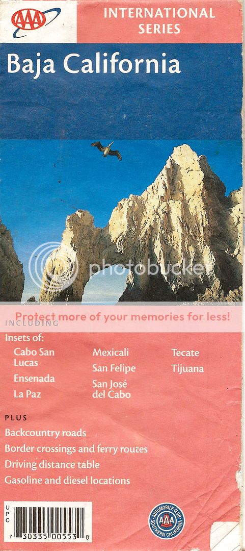
In 2001, the Cabo San Lucas arch replaced the terrain map:
In 2003 it showed some kayaks on the beach at Bahia Concepcion...
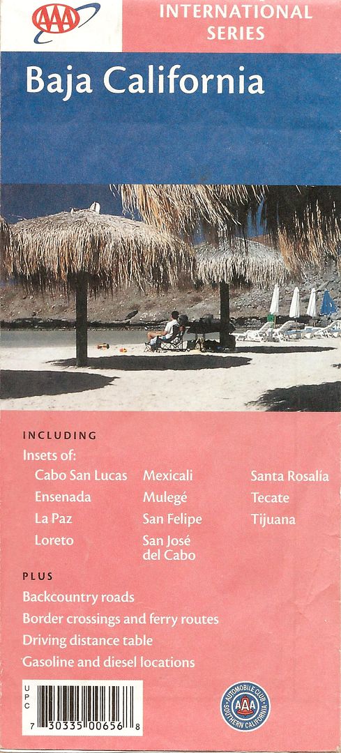
In 2004, we see some beach palapas:
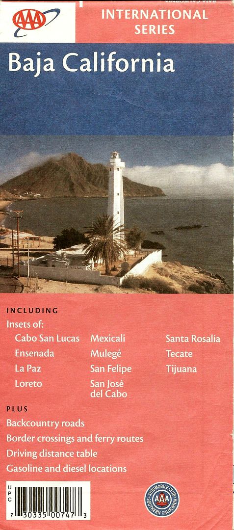
In 2007, the San Felipe lighthouse:
In 2010, kayaks on the beach, similar to the 2003 cover:
For a few years, ending in 1974, the map had the browntone map and inside was a highly detailed map of northern Baja to just south of El Rosario and
Puertecitos. On the other side, was a less detailed, smaller scale version of their 1960's map...
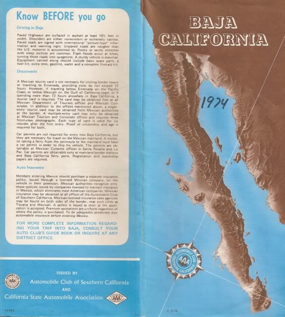
These early 70's maps are gold... for the northern Baja detail. Howard Gulick, of the Lower California Guidebook had assisted them in producing a
better map, I had heard.
Adios AAA Baja Map, you were a great driving aid with mileages on all the roads, gas station locations, and fun for trip planning. Score even used
them for race course maps for many years.
[Edited on 1-14-2015 by David K]
[Edited on 9-13-2022 by David K]
|
|
|
StuckSucks
Super Nomad
Posts: 2306
Registered: 10-17-2013
Member Is Offline
|
|
For a down-and-dirty map, there was nothing better.
|
|
|
Mexitron
Ultra Nomad
Posts: 3397
Registered: 9-21-2003
Location: Fort Worth, Texas
Member Is Offline
Mood: Happy!
|
|
Glad I've hung on to all mine over the years. Being a cartographer for the AAA Baja mapping expeditions would been the best job ever!
|
|
|
PaulW
Ultra Nomad
Posts: 3005
Registered: 5-21-2013
Member Is Offline
|
|
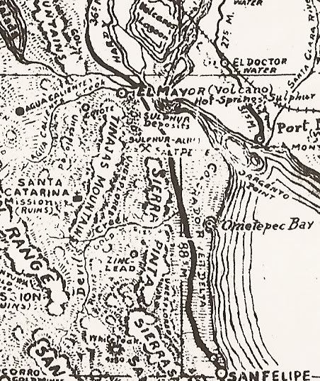
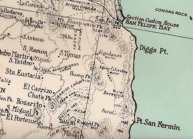
Interesting. In the 1975 SF image the coastal wash names shown are no longer used nor are they named on any of my maps. Only Percebu & Matomi are
recognized? Agua Caliente has greatly changed since then.
The major storms carve up the drainage's and make new ones. Such it is.
PW
|
|
|
David K
Honored Nomad
Posts: 64480
Registered: 8-30-2002
Location: San Diego County
Member Is Offline
Mood: Have Baja Fever
|
|
Quote: Originally posted by PaulW  | Interesting. In the 1975 SF image the coastal wash names shown are no longer used nor are they named on any of my maps. Only Percebu & Matomi are
recognized? Agua Caliente has greatly changed since then.
The major storms carve up the drainage's and make new ones. Such it is.
PW |
That was the 1974 map and the Arroyo Agua Caliente does flow to Punta Diggs but the wash from Valle Chico to the coast had a name change, perhaps from
new Mexican topos published that year? Huatamole being the new name, as you know. Agua Caliente wash enters Huatamote via Arroyo Parral. A name shell
game!
|
|
|
PaulW
Ultra Nomad
Posts: 3005
Registered: 5-21-2013
Member Is Offline
|
|
Then we find the locals inventing even more new names. In my blog I try to document all the names for places and washes around SF, but these old names
are hard to come by since the old printed maps are before my time.
PW
|
|
|
David K
Honored Nomad
Posts: 64480
Registered: 8-30-2002
Location: San Diego County
Member Is Offline
Mood: Have Baja Fever
|
|
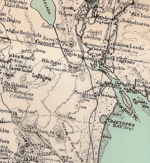
1941 Map San Felipe area...
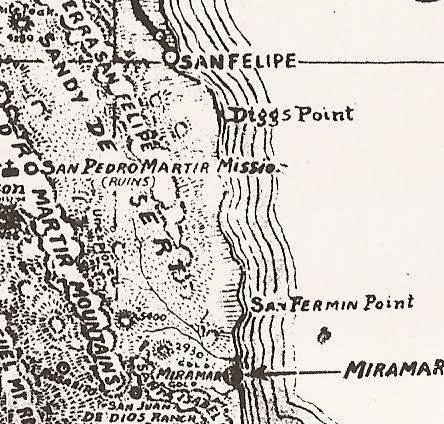
Note the 'unexplored' area of Valle Chico!
|
|
|
David K
Honored Nomad
Posts: 64480
Registered: 8-30-2002
Location: San Diego County
Member Is Offline
Mood: Have Baja Fever
|
|
1930 Map, San Felipe area...
[Edited on 1-14-2015 by David K]
|
|
|
StuckSucks
Super Nomad
Posts: 2306
Registered: 10-17-2013
Member Is Offline
|
|
Ahhhh ... the good old days when you had to catch the Puertocitos road from Highway 5 in town (also, to get to the airport). Isn't the turn-off sign
still there (albeit very tired)?
|
|
|
David K
Honored Nomad
Posts: 64480
Registered: 8-30-2002
Location: San Diego County
Member Is Offline
Mood: Have Baja Fever
|
|
| Quote: | | Ahhhh ... the good old days when you had to catch the Puertocitos road from Highway 5 in town (also, to get to the airport). Isn't the turn-off sign
still there (albeit very tired)? |
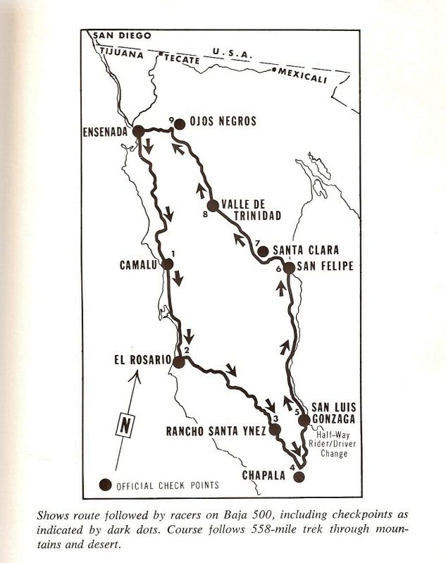
The old road leaves the pavement just past the south Pemex station... you can see it head straight south going for miles. Score gets to use it for
racing now... well Score and BSC raced the 1000 on it and Norra before for the original Baja 500.
1975 Baja 1000 (Score's first 1000):
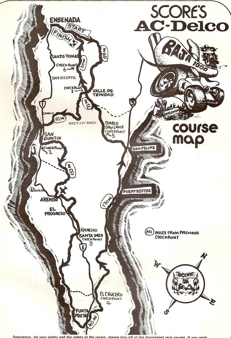
1972 NORRA Baja 500:
[Edited on 1-14-2015 by David K]
|
|
|
StuckSucks
Super Nomad
Posts: 2306
Registered: 10-17-2013
Member Is Offline
|
|
| Quote: Originally posted by David K |
The old road leaves the pavement just past the south Pemex station... you can see it head straight south going for miles. |
Yep, know where that is. But wasn't there a point in time before that where the turn-off to the airport and Puertocitos was off Highway 5? No?
|
|
|
David K
Honored Nomad
Posts: 64480
Registered: 8-30-2002
Location: San Diego County
Member Is Offline
Mood: Have Baja Fever
|
|
| Quote: Originally posted by StuckSucks | | Quote: Originally posted by David K |
The old road leaves the pavement just past the south Pemex station... you can see it head straight south going for miles. |
Yep, know where that is. But wasn't there a point in time before that where the turn-off to the airport and Puertocitos was off Highway 5? No?
|
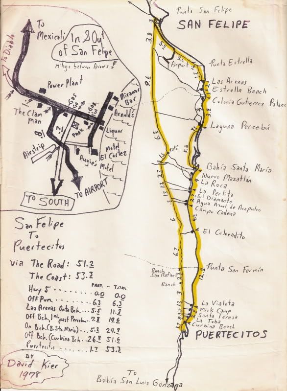
You mean from the highway entering town and before the road south was paved to the airport? I need clarification by what you mean Hwy. 5? The highway
originally ended at the main business street the parallels the beach, and the Puertecitos road headed south from it 0.3 mile back towards Mexicali on
the highway.
Here's a map I made in 1978 that shows going to Puertecitos via the road or via the beach... note in insert close up map of San Felipe that shows the
newly paved airport road. This was before the 4 lane entrance road, before the traffic circle, or the arches. The Clam Man was in business, and waved
to us from his barber chair as we passed by his clam shop:
[Edited on 1-14-2015 by David K]
|
|
|
StuckSucks
Super Nomad
Posts: 2306
Registered: 10-17-2013
Member Is Offline
|
|
| Quote: Originally posted by David K | | Quote: Originally posted by StuckSucks | | Quote: Originally posted by David K |
The old road leaves the pavement just past the south Pemex station... you can see it head straight south going for miles. |
Yep, know where that is. But wasn't there a point in time before that where the turn-off to the airport and Puertocitos was off Highway 5? No?
|
You mean from the highway entering town and before the road south was paved to the airport? I need clarification by what you mean Hwy. 5?
|
Yes, I meant taking off from east of the gas station (pre glorieta), but now that I see your map, I guess we're sort of saying the same thing. I was
starting at Highway 5, you were starting a little farther south on the airport road.
And yes to the clam man and the lack of arches! And the traffic light didn't work either.
I think '78 was my first year going to Puertocitos to experience the springs with prehistoric bugs.
|
|
|
PaulW
Ultra Nomad
Posts: 3005
Registered: 5-21-2013
Member Is Offline
|
|
| Quote: Originally posted by StuckSucks | Ahhhh ... the good old days when you had to catch the Puertocitos road from Highway 5 in town (also, to get to the airport). Isn't the turn-off sign
still there (albeit very tired)?
=====
Guess I will have to go look for the sign.
Now days no racing on OPR until S of the village of las Minatas. And the road is paved to the S side of the village.
There is an old SCORE track with a couple of signs in the track beside the SW airport fence. Code used that track or a parallel one to connect to
Percebu road then headed west to Huatamote.
The pipeline road from Km0 west to OPR is marginal, but we still use it.
The old road that went east south of the airport is fenced off by the owner of the valley of giants.
The S PMEX is still unoccupied starting the second year.
PW |
|
|
|
David K
Honored Nomad
Posts: 64480
Registered: 8-30-2002
Location: San Diego County
Member Is Offline
Mood: Have Baja Fever
|
|
| Quote: Originally posted by soulpatch | I remember long ago when we were at Camp Gecko and you, David, was there, too.
The guy from AAA came rolling through and was looking around so we chatted him up.
We told him a few things he asked about but, I do believe, I sent him your way...
My memory is not perfect, though! |
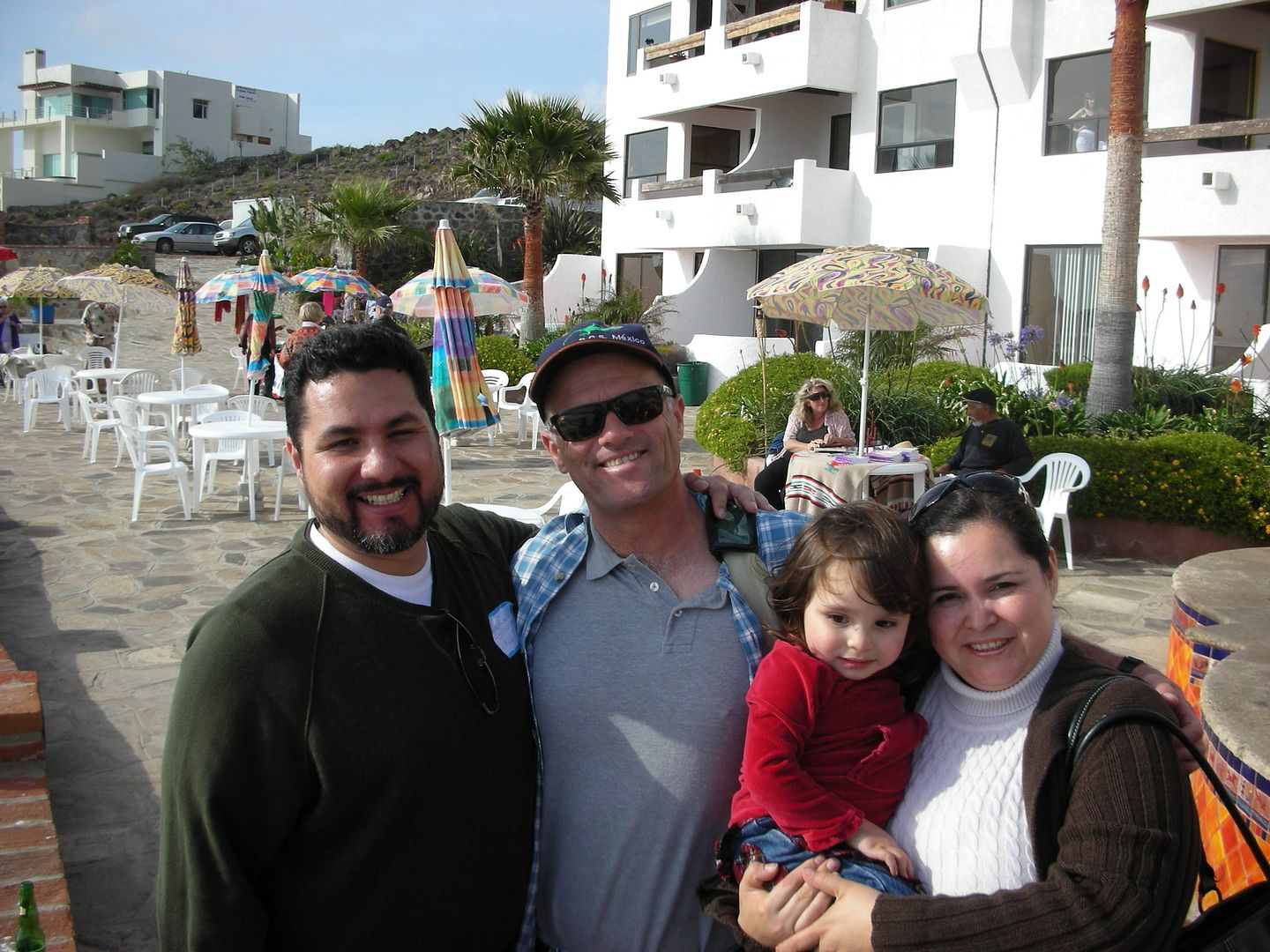
LOL... mine is questionable too, sometimes. I don't remember meeting the Auto Club guide author at Camp Gecko back in 2002 or 3, but I did meet him
(David Brackney) in May, 2007, at the Pyramid Resort Book Signing. Here was David's 'company car' and a couple photos of him I took with Antonio (Baja
Cactus).


[Edited on 9-2-2022 by David K]
|
|
|
ehall
Super Nomad
Posts: 1906
Registered: 3-29-2014
Location: Buckeye, Az
Member Is Offline
Mood: It's 5 o'clock somewhere
|
|
It's funny that on the 1927 map the Old Mill at San Quentin is named the Old Mill. When was it the New Mill?
|
|
|
PaulW
Ultra Nomad
Posts: 3005
Registered: 5-21-2013
Member Is Offline
|
|
David K,
I have several versions of the Almanc and I cannot decode the publish dates.
Both small and large format and the folding map.
Can you help?
Thanks, Paul
|
|
|
David K
Honored Nomad
Posts: 64480
Registered: 8-30-2002
Location: San Diego County
Member Is Offline
Mood: Have Baja Fever
|
|
| Quote: Originally posted by ehall | | It's funny that on the 1927 map the Old Mill at San Quentin is named the Old Mill. When was it the New Mill? |
There was a flour mill (remains of the mill engine still there) constructed by British wheat farmers there. Remains of the pier are just over a mile
south (Muelle Viejo). They even built several miles of railroad line (to bring the flour to the U.S.). The causeway that creates the narrow opening to
go north of the mill was for the railroad. The bridge that was there collapsed, and the train engine is in the bay (or was).
The project's success all depended on rain for irrigation. The rain in San Quintin (as in much of Southern California) isn't consistent year to year.
It was a very wet year in 1889, and wheat grew easily.
When was it a new mill?
The project began about 1885 by Americans, but was purchased by the British about 1890.
So in 1927, it was an Old Mill!
[img]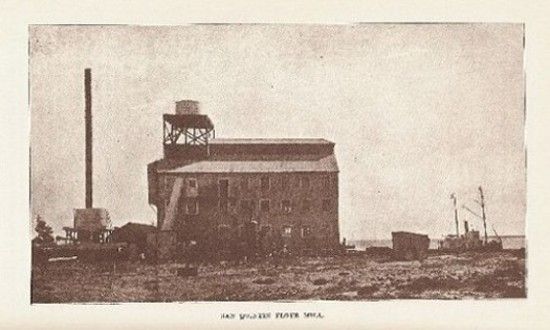 [/img] [/img]
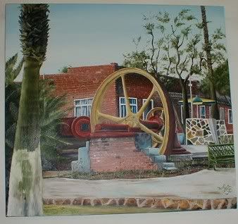
Hugo Lopez painting of the Mill as seen today:
|
|
|
David K
Honored Nomad
Posts: 64480
Registered: 8-30-2002
Location: San Diego County
Member Is Offline
Mood: Have Baja Fever
|
|
| Quote: Originally posted by PaulW | David K,
I have several versions of the Almanc and I cannot decode the publish dates.
Both small and large format and the folding map.
Can you help?
Thanks, Paul |
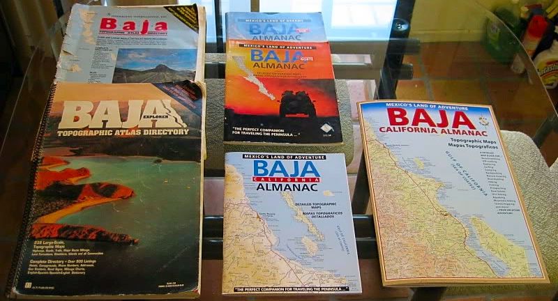
All from Landon Crumpton...
*The first BIG Baja Topo Atlas (top left) was published in 1986.
*The second BIG Baja Topo Atlas Atlas (bottom left) was published in 1991.
*The (pair) Norte and Sur Baja California Almanac was published about 1998 (there is no date inside, but ads inside it place it after 1996 and before
2001).
*The all color, single book, Baja California Almanac, and the folding map were published in 2003.
*The larger size, but smaller detail, Almanac was published in 2009.
|
|
|
PaulW
Ultra Nomad
Posts: 3005
Registered: 5-21-2013
Member Is Offline
|
|
All is good Now. All my maps now have dates.
Thanks.
|
|
|
| Pages:
1
2 |


