| Pages:
1
2 |
TMW
Select Nomad

Posts: 10659
Registered: 9-1-2003
Location: Bakersfield, CA
Member Is Offline
|
|
Robert is one of a kind and is all ours. We would not share him with anyone. He is also a great cook.
|
|
|
TMW
Select Nomad
Posts: 10659
Registered: 9-1-2003
Location: Bakersfield, CA
Member Is Offline
|
|
Quote: Originally posted by MICK  | Tw. Wish I could have got off to go. Seems I am busier now that I'm retired. Looks like a great trip. Stop by next time. We still have an extra room.
Some daynI'll make one of these trips.
Mick |
Mick you would have loved it. Hope to stop by your place on my next trip.
|
|
|
John M
Super Nomad
Posts: 1906
Registered: 9-3-2003
Location: California High Desert
Member Is Offline
|
|
second attempt to add photos to Tom's report
Or maybe it's my third try! Stay tuned as I have to do them one at a time, can't seem to keep Photobucket open same time as Nomad so it's a process of
time spent on this.

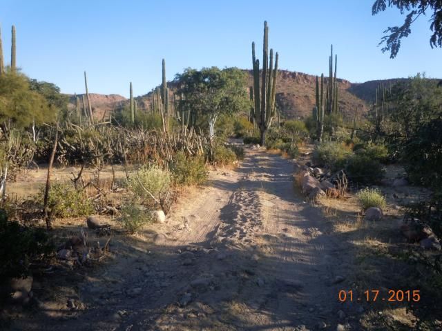
This is about 8 miles north of San Francisquito, the trail wanders around and through a few 4x4 washes to land at the beach. 28 27.255 N & 112
59.405 W
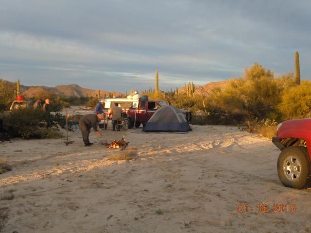
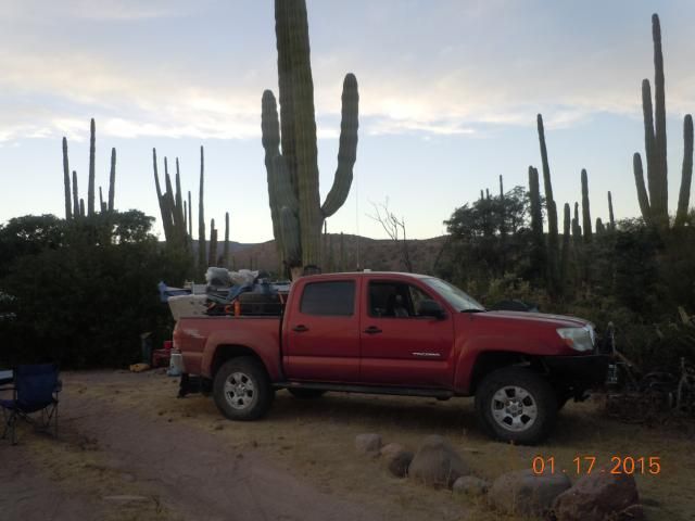
Due to the miserable conditions at San Francisquito, including lots of wind, we found a campsite inland a few miles. TW tending to the fire.
28 22.930 N & 112 57.802 W
This was our furthest south campsite along the No Wimps Trail. Beyond here the road/trail was simply gone - This is about six miles west of the Gulf,
near the road to Rancho Santa Barbara. The gps reading for this and the following photo is: 28 07.184 N & 112 57.519 W Hurricane Odile
wrecked havoc all along the existing road just to get to this point.
As we slowly began our return to the north, this photo just begged to be taken. About the same location as the photo immediately above.
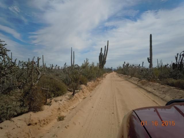
Road between Villa Jesus Maria and El Arco, somewhere around gps 28 09.060 N and 113 44.731 W
John M
[Edited on 1-29-2015 by John M]
[Edited on 1-29-2015 by John M]
[Edited on 1-29-2015 by John M]
[Edited on 1-29-2015 by John M]
[Edited on 1-29-2015 by John M]
|
|
|
David K
Honored Nomad
Posts: 64478
Registered: 8-30-2002
Location: San Diego County
Member Is Offline
Mood: Have Baja Fever
|
|
Thank you John! Appreciate your efforts even if you are being challenged by the Internet gods in posting this. When you do the final edit, you can
erase all the previous "Edited on 1-29..." auto posts, if you don't want us to see how many times you tried!

Thanks for the GPS locations! I think I will make a map with Google Earth to show them!
|
|
|
David K
Honored Nomad
Posts: 64478
Registered: 8-30-2002
Location: San Diego County
Member Is Offline
Mood: Have Baja Fever
|
|
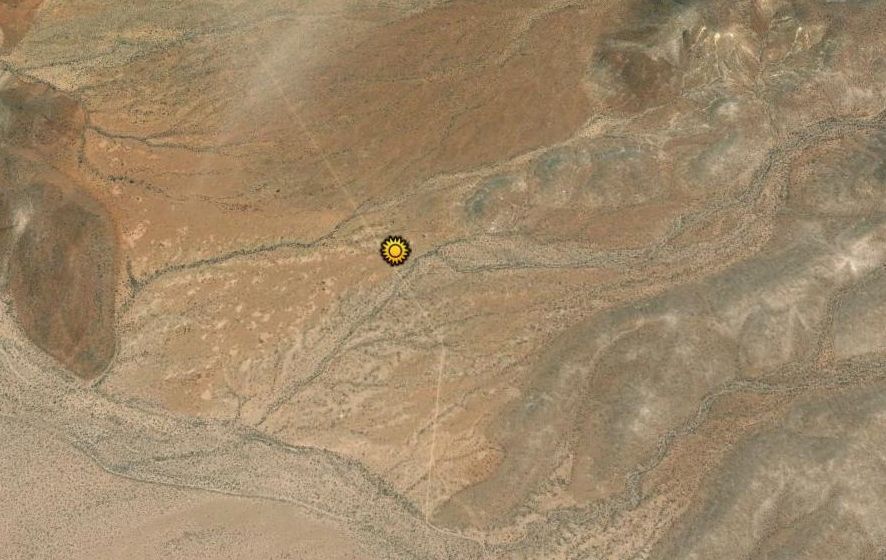
Thanks to John M for the GPS!
Here are the waypoint locations John M gave (sun logos):
All images are with NORTH at the top...
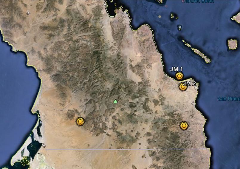
JM 1 is not in the gulf, but looks like it on zoom out!
#3 is south of JM 2 and #4 is way off to the west.
--------------------------------------------------------------------------------------------------------
Here is JM 1 close in:
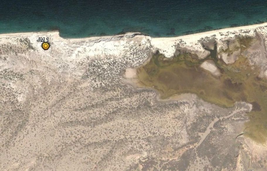
This is about 8 miles north of San Francisquito, the trail wanders around and through a few 4x4 washes to land at the beach. 28 27.255 N & 112
59.405 W
------------------------------------------------------------------------------------------------------
Here is JM 2:
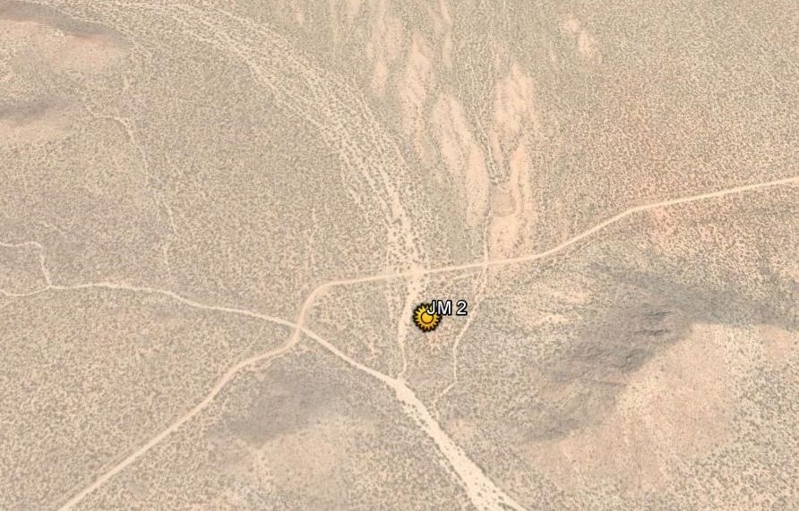
Due to the miserable conditions at San Francisquito, including lots of wind, we found a campsite inland a few miles. TW tending to the fire.
28 22.930 N & 112 57.802 W
--------------------------------------------------------------------------------------------------------
Here is JM 3:
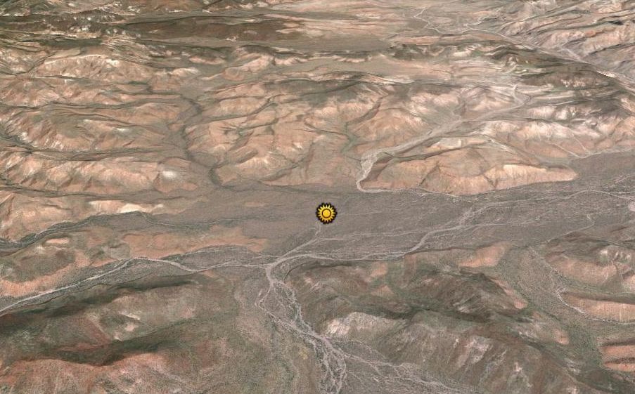
This was our furthest south campsite along the No Wimps Trail. Beyond here the road/trail was simply gone - This is about six miles west of the Gulf,
near the road to Rancho Santa Barbara. The gps reading for this and the following photo is: 28 07.184 N & 112 57.519 W Hurricane Odile
wrecked havoc all along the existing road just to get to this point.
-------------------------------------------------------------------------------------------------------------
Here is JM 4, out west...
Road between Villa Jesus Maria and El Arco, somewhere around gps 28 09.060 N and 113 44.731 W
|
|
|
Whale-ista
Super Nomad
Posts: 2009
Registered: 2-18-2013
Location: San Diego
Member Is Offline
Mood: Sunny with chance of whales
|
|
Thanks for a wonderful trip report. I'd love to go explore the beach near the big Vizcaino hook. (I'm gradually exploring more of the Pacific coast in
between enjoying all the baby whales.)
And I hate it when all my text disappears! I agree, prep it in word or text document and save it before it disappears into the ethernet.
\"Probably the airplanes will bring week-enders from Los Angeles before long, and the beautiful poor bedraggled old town will bloom with a
Floridian ugliness.\" (John Steinbeck, 1940, discussing the future of La Paz, BCS, Mexico)
|
|
|
Baja Bug
Newbie
Posts: 8
Registered: 1-24-2015
Member Is Offline
|
|
your trip
Thanks again for your reply on my upcoming atv trip. We're looking for possable alturnative trips. Question: On your trip you say you couldn't get
past the "Y" in the roads to Santa Barbara & San Miguel. Do you think we could get thru on our atv's? Looks like the coastal area past San Miguel
would be worth exploring. Don't know how to u2u yet. This is all new to me. Mucho Gracias ...Bob "Baja Bug"
|
|
|
David K
Honored Nomad
Posts: 64478
Registered: 8-30-2002
Location: San Diego County
Member Is Offline
Mood: Have Baja Fever
|
|
| Quote: Originally posted by Baja Bug | | Thanks again for your reply on my upcoming atv trip. We're looking for possable alturnative trips. Question: On your trip you say you couldn't get
past the "Y" in the roads to Santa Barbara & San Miguel. Do you think we could get thru on our atv's? Looks like the coastal area past San Miguel
would be worth exploring. Don't know how to u2u yet. This is all new to me. Mucho Gracias ...Bob "Baja Bug" |
Next to the box where you are reading a post, is a button 'u2u'. Click on that and you open a private message service to that Nomad. When a new u2u
comes to you, you will see (in blue text) that you have a u2u... it is in the upper right corner of your Nomad page... just click on it!
|
|
|
John M
Super Nomad
Posts: 1906
Registered: 9-3-2003
Location: California High Desert
Member Is Offline
|
|
Baja Bug - ATVs beyond??
Ancient maps would, at times, have the phrase "Terra Incognita" or with the loosely translated and somewhat more imaginative "Beyond This Place There
be Dragons" penciled along the margins or at the edge of a map. That pretty well describes what the rest of road to San Miguel can be described as
today.
The actual route TW so painstakingly and accurately laid out simply vanished probably within a quarter mile of the sign to the ranches that he posted.
We got to the edge of a major wash with recent tracks headed westerly, toward Rancho Santa Barbara, and found the road heading in the same direction.
Huge boulders blocked any other travel in the direction we would have gone.
What we couldn't find was the route to the east. Downed trees, boulders, devastation all around. We walked, and drove a couple of dead ends in the
direction we wanted to go. There was no getting through. TW thought that perhaps some bikes had gotten through since Odile but there were no bike
tracks spotted at all, since we left the El Barril area. The road we followed from El Barril soon gets to Rancho La Illusion. After La Illusion the
road surface deteriorated crossing a couple of very rocky arroyos. We soon picked up the tire tracks of one vehicle, obviously a truck and likely from
Rancho Santa Barbara, not an "off road" tire tread pattern. As lead vehicle, we spotted the tracks from time to time for the next 15 or so miles.
Where the road we were following came to an end, a fainter route, marked all along with rock cairns (ducks) no doubt lead to Santa Barbara.
We had stopped at La Illusion on the way south to inquire but the place was only inhabited by a couple of friendly dogs. Later in the trip we came
across the rancher who told Tom that the route beyond where we went was simply gone. TW puts faith in this rancher's knowledge of the area.
Had we gotten to San Miguel, and then to the coast we would have been faced with yet another issue - gasoline. The driving was pretty slow and I for
one was using more fuel than I anticipated. Even with the ten extra gallons carried we would have had to make a decision to return before too long as
the nearest gasoline we were certain of would be at Guerrero Negro or Villa Jesus Maria.
Tom can fill in the blanks and add info as he's driven this route a couple of times pre Odile.
Someone should take up the challenge, Baja Bug, and with time, good equipment, and a sense of adventure you just might be the guy to do it! Good luck.
U2U if you want more info like gps data.
John M
[Edited on 1-30-2015 by John M]
|
|
|
TMW
Select Nomad
Posts: 10659
Registered: 9-1-2003
Location: Bakersfield, CA
Member Is Offline
|
|
| Quote: Originally posted by Baja Bug | | Thanks again for your reply on my upcoming atv trip. We're looking for possable alturnative trips. Question: On your trip you say you couldn't get
past the "Y" in the roads to Santa Barbara & San Miguel. Do you think we could get thru on our atv's? Looks like the coastal area past San Miguel
would be worth exploring. Don't know how to u2u yet. This is all new to me. Mucho Gracias ...Bob "Baja Bug" |
It is possible an ATV could get thru, worth a try anyway. I have done this trail from El Barril to San Ignacio twice last year going both ways. The
trail down the coast is beautiful, no one there except you. Here is a trip report from last April, we went from San Ignacio up to El Barril.
http://forums.bajanomad.com/viewthread.php?tid=73500
|
|
|
wessongroup
Platinum Nomad
Posts: 21152
Registered: 8-9-2009
Location: Mission Viejo
Member Is Offline
Mood: Suicide Hot line ... please hold
|
|
Thanks much ... 
|
|
|
StuckSucks
Super Nomad
Posts: 2305
Registered: 10-17-2013
Member Is Offline
|
|
Great trip, thanks for sharing! I was last at Malarrimo in the 80s - I NEED to get back there. Like you, we encountered that crusty mud - dangerous
business.
|
|
|
BornFisher
Super Nomad
Posts: 2103
Registered: 1-11-2005
Location: K-38 Santa Martha/Encinitas
Member Is Offline
|
|
Well that`s putting some adventure into a trip! Thanks for the report and the effort to post it all. It was GREAT!!!
|
|
|
gueribo
Nomad
Posts: 458
Registered: 10-16-2014
Member Is Offline
|
|
Just got to this report. Thanks for taking so much time with it. I love the narrative and photos.
|
|
|
David K
Honored Nomad
Posts: 64478
Registered: 8-30-2002
Location: San Diego County
Member Is Offline
Mood: Have Baja Fever
|
|
So much Baja... So little time!!!
|
|
|
David K
Honored Nomad
Posts: 64478
Registered: 8-30-2002
Location: San Diego County
Member Is Offline
Mood: Have Baja Fever
|
|
Bump for DirkEXC
Any news on the El Barril to San Ignacio track?
|
|
|
| Pages:
1
2 |


