| Pages:
1
2 |
David K
Honored Nomad

Posts: 64476
Registered: 8-30-2002
Location: San Diego County
Member Is Offline
Mood: Have Baja Fever
|
|
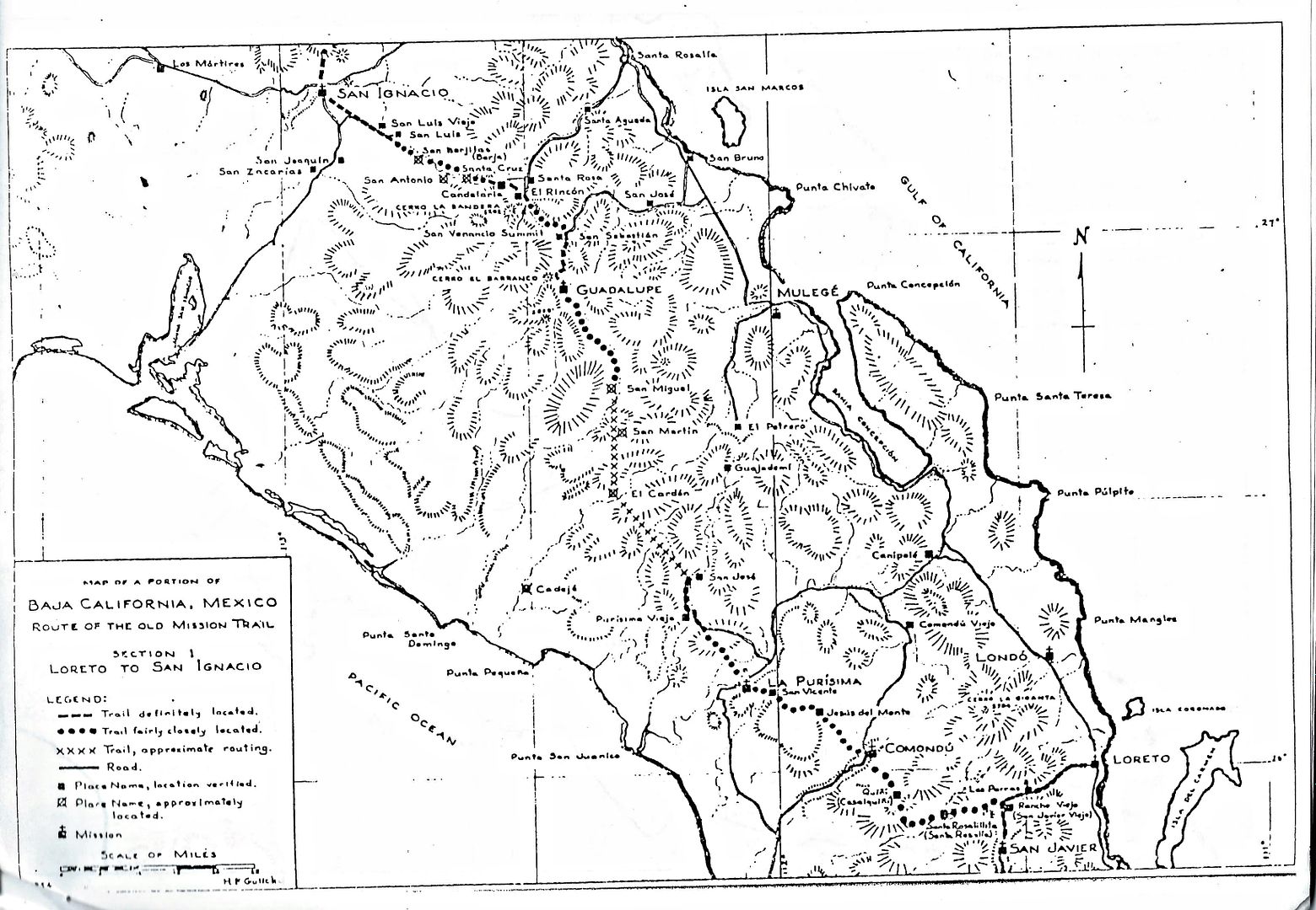
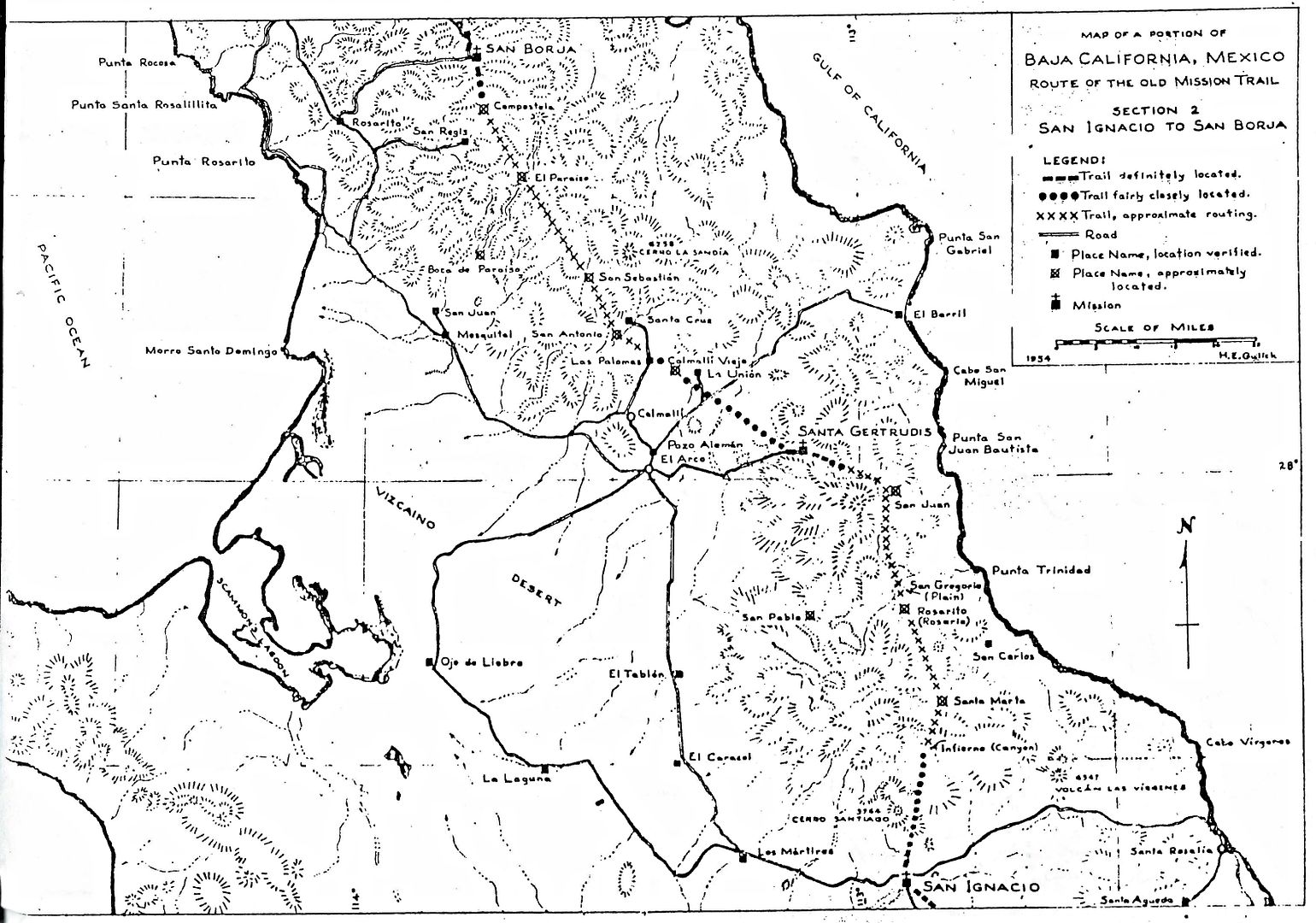
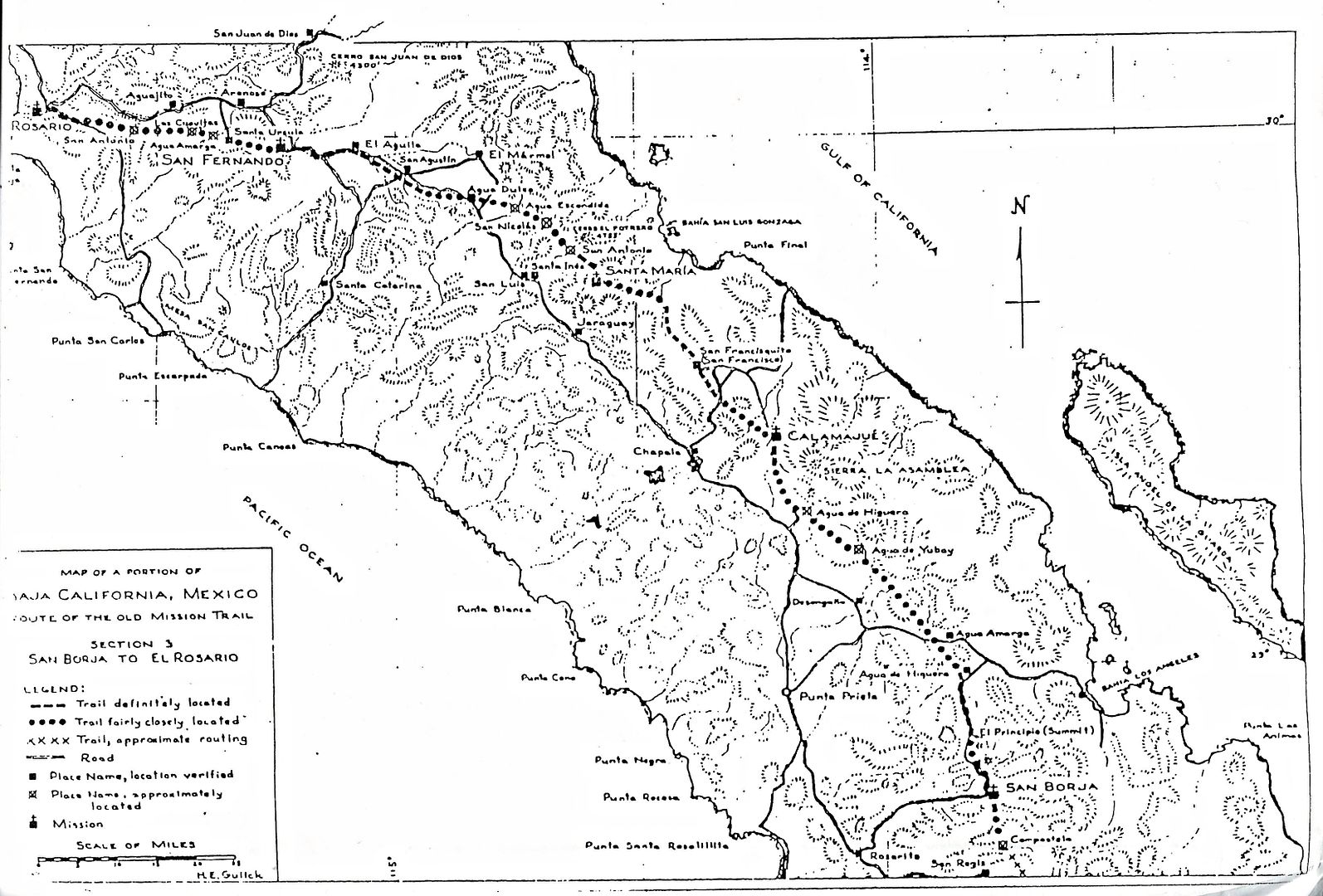
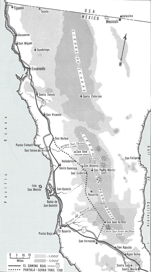
1954 EL CAMINO REAL REPORT and maps by Howard Gulick; and Harry Crosby's 1974 and '77 maps
While researching for the future Lower California Guidebook first edition, from 1950-1954, Howard Gulick made notes on any old trails he saw cross the
few automobile roads. Gulick explored those trails and interviewed the ranchers who lived on or near them. Gulick also flew over the trails to better
map and document their location. Because going to Baja inspires a desire to learn the history of the land that was California first, Gulick researched
the Jesuit, Franciscan and Dominican notes on their 'highway' between Loreto and San Diego.
While Gulick does mention the mission road a couple times in the Guidebook (1956, 58, 62, 70 editions), his detailed notes and maps were never
published. Harry Crosby who was introduced to the Camino Real as a photographer in 1967 working on 'The Call to California' 1968 fell in love with
Baja and the history of the mission road. Using Howard Gulick's notes and maps, Harry traveled as much of the trail as possible by mule from the
missions of San Jose de Comondu to San Fernando de Velicata. Crosby then followed Serra's route north into the mountains to San Isodoro and eneded at
the Meling Ranch. The Dominicans first mission was at El Rosario, and Gulick takes us to that point in this 1954 report.
Highway One from El Rosario to San Diego is mostly on or parallel to El Camino Real of 1775 +.
In 1959, Howard Gulick made a revision to the 1954 report, and I have part of it (Loreto to almost San Ignacio). I will add it to this thread in the
near future.
Original Credit for preserving these historic papers goes to Baja book and map collector, Norm Christie (Rockman on Nomad). This research by Howard
Gulick should be preserved beyond our personal collections for future explorers and history researchers. Howard openly shared his love for Baja and
helped other authors over the years. He worked closely with Harry Crosby when Harry researched his 1974 'The King's Highway in Baja California'.
Now, let's hope that my job of scanning the 21 pages (18 text pages, 3 maps) of the copied report is clear enough to read... at least most of it...
ENJOY!
About a dozen years ago, I first shared the maps and I used the Baja Almanac to show where the Camino Real was, in it. Here is that web page: http://www.vivabaja.com/ECR/
In 1977, Harry Crosby had detailed maps made of the Camino Real routes in Baja , from Loreto to Tijuana... here they are (click on the small map
images to enlarge them:
https://web.archive.org/web/20160329012947/http://www.sandie...
In 2018, new on the ground researched GPS/Google Earth map of El Camino Real from Loreto to El Rosario: http://caminorealbaja.com/
[Edited on 4-27-2021 by David K]
|
|
|
elbeau
Nomad
Posts: 256
Registered: 3-2-2011
Location: Austin, TX
Member Is Offline
|
|
I love these descriptions and maps. Thanks!
Any idea what happened to Gullick's notes after Crosby used them?
|
|
|
David K
Honored Nomad
Posts: 64476
Registered: 8-30-2002
Location: San Diego County
Member Is Offline
Mood: Have Baja Fever
|
|
Quote: Originally posted by elbeau  | I love these descriptions and maps. Thanks!
Any idea what happened to Gullick's notes after Crosby used them? |
Other than the copy you see above, and the 1959 revision (I will add later), I don't know of any other use for them.
When I chatted with Walt Wheelock (La Siesta Press and co-author with Gulick on the 1975 & 1980 revised 'Baja California Guidebook') back in 1984,
he wanted to publish other works by Gulick, namely the large scale hand drawn maps he made. The great maps in the original guidebook were abbreviated,
reduced scale versions. I saw once the large Gulick maps, they were awesome. Wheelock didn't think the market was large enough to pay for the
publishing costs. Now both Gulick and Wheelock are gone, and I think Gulick's map collection is at a library at UCSD.
Here are the Lower California Guidebook Maps (1962 edition)... http://biology.fullerton.edu/biol517dje/maps/baja_1962.html
(click on the peninsula map to bring up the close in map)
|
|
|
elbeau
Nomad
Posts: 256
Registered: 3-2-2011
Location: Austin, TX
Member Is Offline
|
|
The dust cover for my copy of the guidebook mentions that additional maps are available for $1.95. Are these the more detailed maps? If so then
perhaps I can find a copy of the book that also includes the maps.
|
|
|
elbeau
Nomad
Posts: 256
Registered: 3-2-2011
Location: Austin, TX
Member Is Offline
|
|
400 of Gulick's images are presented online at:
http://libraries.ucsd.edu/speccoll/baja/gulick/index.html
|
|
|
David K
Honored Nomad
Posts: 64476
Registered: 8-30-2002
Location: San Diego County
Member Is Offline
Mood: Have Baja Fever
|
|
No, the extra maps they sold separate were the same ones that were in the book but a bit smaller. Yes the Gulick photos are great. I have posted many
of them. He took a lot of mission photos in the 50's and early 60's.
Here is the extra maps booklet cover...
[Edited on 3-7-2015 by David K]
|
|
|
mtgoat666
Select Nomad
Posts: 17284
Registered: 9-16-2006
Location: San Diego
Member Is Offline
Mood: Hot n spicy
|
|
hey mission-heads:
which canyon did the padres use to travel to/from mision san pedro martir on the east scarp of the plateau? i understand the SPM mission had a trail
that went east toward san felipe,... do you know which canyon?
|
|
|
David K
Honored Nomad
Posts: 64476
Registered: 8-30-2002
Location: San Diego County
Member Is Offline
Mood: Have Baja Fever
|
|
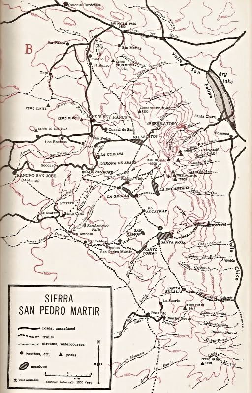
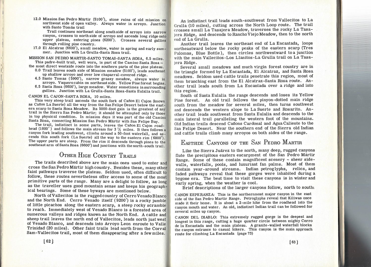
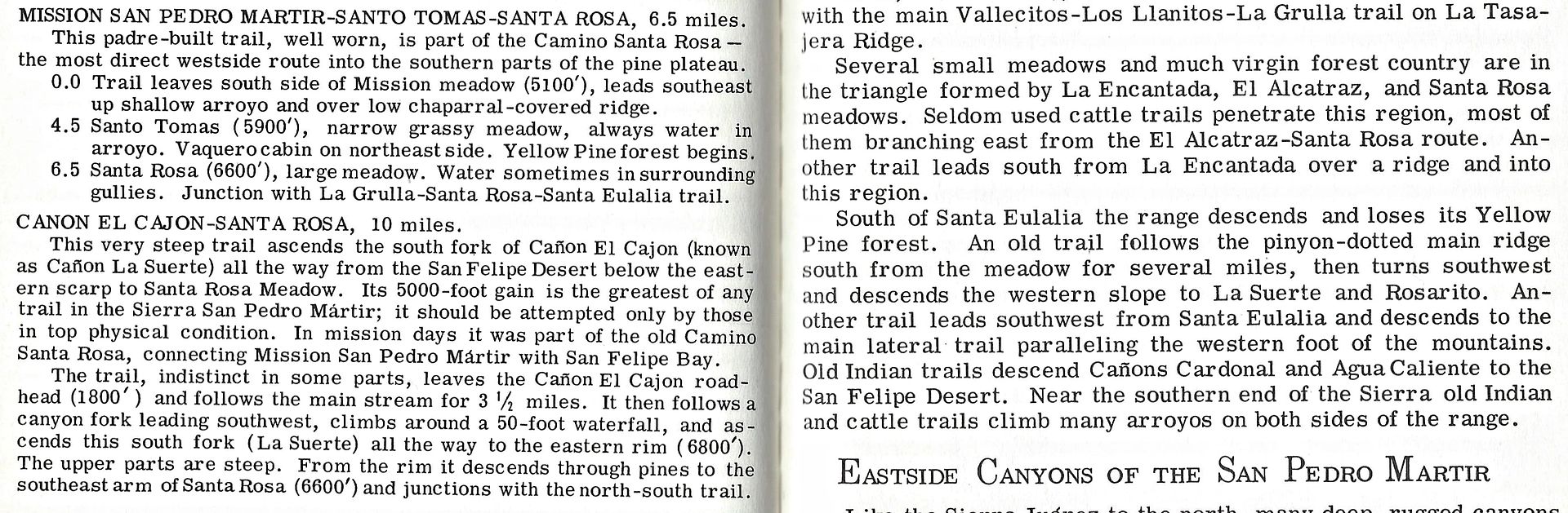
There were Indian trails that were also used by the padres to go to San Felipe for supplies. The main one was in El Cajon Canyon, but there was one in
Agua Caliente Canyon, too.
Here is a map that shows both trails...
[Edited on 3-7-2015 by David K]
|
|
|
PaulW
Ultra Nomad
Posts: 3005
Registered: 5-21-2013
Member Is Offline
|
|
Does anybody have a hike report for the two trails?
|
|
|
David K
Honored Nomad
Posts: 64476
Registered: 8-30-2002
Location: San Diego County
Member Is Offline
Mood: Have Baja Fever
|
|
Yes, in this book (where the map above came from):
[Edited on 4-27-2021 by David K]
|
|
|
David K
Honored Nomad
Posts: 64476
Registered: 8-30-2002
Location: San Diego County
Member Is Offline
Mood: Have Baja Fever
|
|
I remember reading about a hike down El Cajon Canyon from the Meling Ranch in this books, as well....
|
|
|
David K
Honored Nomad
Posts: 64476
Registered: 8-30-2002
Location: San Diego County
Member Is Offline
Mood: Have Baja Fever
|
|
With new interest in walking or riding on El Camino Real, I am bumping this post about the first modern, detailed directions of the mission trail.
Harry Crosby utilized Howard Gulick's work when he wrote The King's Highway in Baja California (1974).
|
|
|
gueribo
Nomad
Posts: 458
Registered: 10-16-2014
Member Is Offline
|
|
Nice bump. Thanks.
|
|
|
Barry A.
Select Nomad
Posts: 10007
Registered: 11-30-2003
Location: Redding, Northern CA
Member Is Offline
Mood: optimistic
|
|
Great revived post, David. I have one copy of one of Gulick's hand-drawn maps of the Laguna Salada / Sierra Juarez area inherited from my Aunt Becky
McSheehy who knew Howard pretty well, and helped him with his maps to a limited extent. I treasure it, to be sure!
|
|
|
David K
Honored Nomad
Posts: 64476
Registered: 8-30-2002
Location: San Diego County
Member Is Offline
Mood: Have Baja Fever
|
|
| Quote: Originally posted by Barry A. | | Great revived post, David. I have one copy of one of Gulick's hand-drawn maps of the Laguna Salada / Sierra Juarez area inherited from my Aunt Becky
McSheehy who knew Howard pretty well, and helped him with his maps to a limited extent. I treasure it, to be sure! |
Oh, can you please scan and share them???
I was so fortunate that I could meet Howard when I was a kid. It was just before our trip down to the tip by Jeep, in 1966. One of Howard's Glendale
City co-workers lived near us (Andy Anderson). He was the guy responsible for informing my dad about Baja fishing and Jeep Wagoneers... and that
changed my family's life! I remember Howard autographing our copy of his book.
Here are over 2,000 photographs from Howard Gulick during his trips to Baja and Nayarit for his two guidebooks: https://library.ucsd.edu/dc/collection/bb9284741j
There are about 4 photos of Andy Anderson (near Sulfur Mine and Gonzaga Bay, showing Alfonsina's under construction in 1958).
|
|
|
gueribo
Nomad
Posts: 458
Registered: 10-16-2014
Member Is Offline
|
|
Thanks for that link, David. A great resource.
|
|
|
David K
Honored Nomad
Posts: 64476
Registered: 8-30-2002
Location: San Diego County
Member Is Offline
Mood: Have Baja Fever
|
|
Don't expect to sleep once you begin looking at Baja in the 1950s!
Here is another great reading resource for Baja from the last century: http://leighrobertson.net/short.html
|
|
|
David K
Honored Nomad
Posts: 64476
Registered: 8-30-2002
Location: San Diego County
Member Is Offline
Mood: Have Baja Fever
|
|
The Camino Real Mission Road in Baja California continues to be an attraction for hikers and explorers.
The route has been built over by modern roads in many areas but long sections remain where no engineer would ever build a road.
While I have mapped the trail (mostly using satellite images) and transferred the route onto the Baja Almanac map about 8 years ago, it is with much
excitement that I have been communicating with history-loving hikers who wanted to document the authentic mission route. What I had made and showed on
Nomad in the past was based on Howard Gulick's and Harry Crosby's notes and maps and my visually finding the trail in those places.
The new information, based on actual ground travel from Loreto to El Rosario, will fine-tune or correct the previous map, a map for general interest
as to about where El Camino Real in Baja is actually located. I hope to encourage this couple to write a book and produce more detailed maps based on
all their work and documentation.
The historic California El Camino Real is vanishing due to modern highways and other road construction, also to natural erasing from erosion or plant
growth. By keeping the memory and location alive and used by hikers, bikers, and riders, we can preserve El Camino Real into the future.
Many of our (Alta) California ancestors arrived from Baja California using El Camino Real in the days before automobiles and car roads existed on the
peninsula.
|
|
|
David K
Honored Nomad
Posts: 64476
Registered: 8-30-2002
Location: San Diego County
Member Is Offline
Mood: Have Baja Fever
|
|
I have edited the first post with the changed web address for Harry Crosby's maps of 1977 (https://web.archive.org/web/20160329012947/http://www.sandie...)
plus included the new 2018 ECR, ground researched GPS/Google Earth map (http://caminorealbaja.com/).
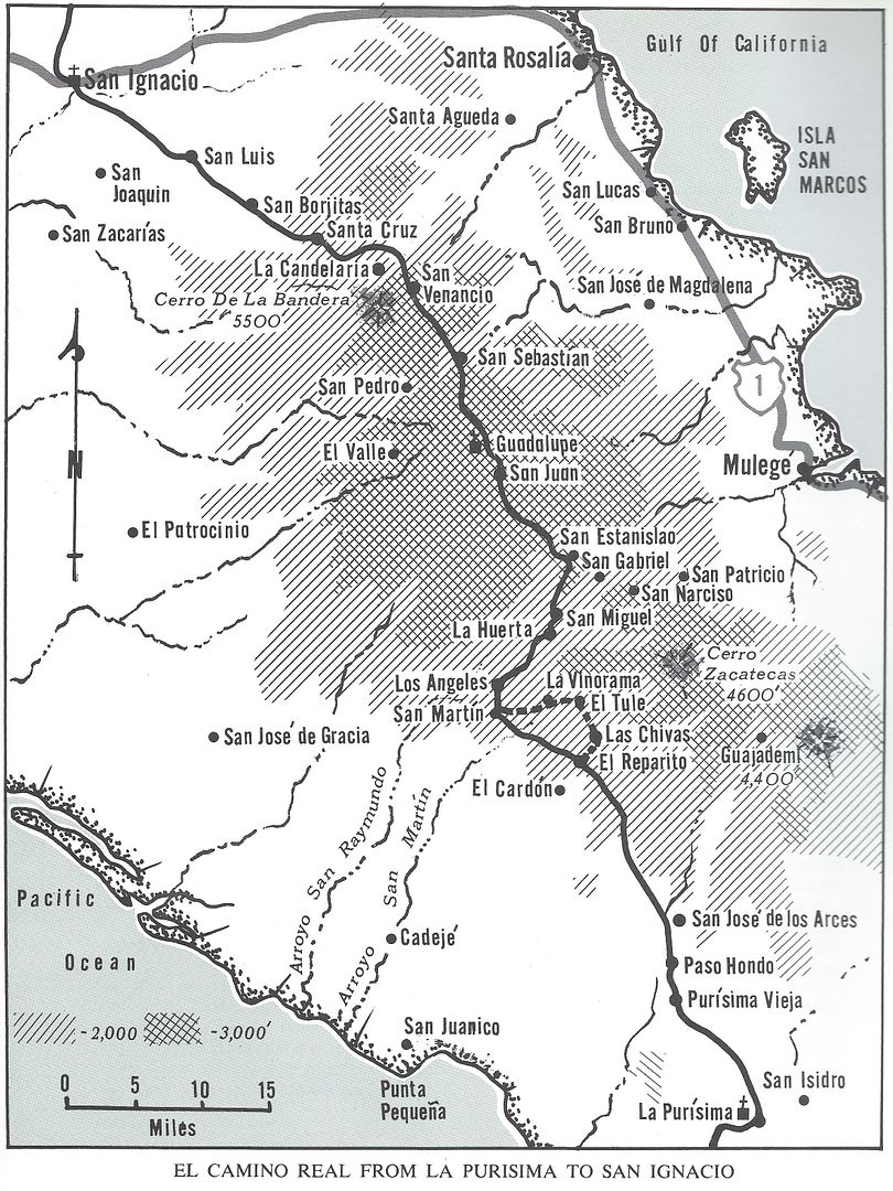
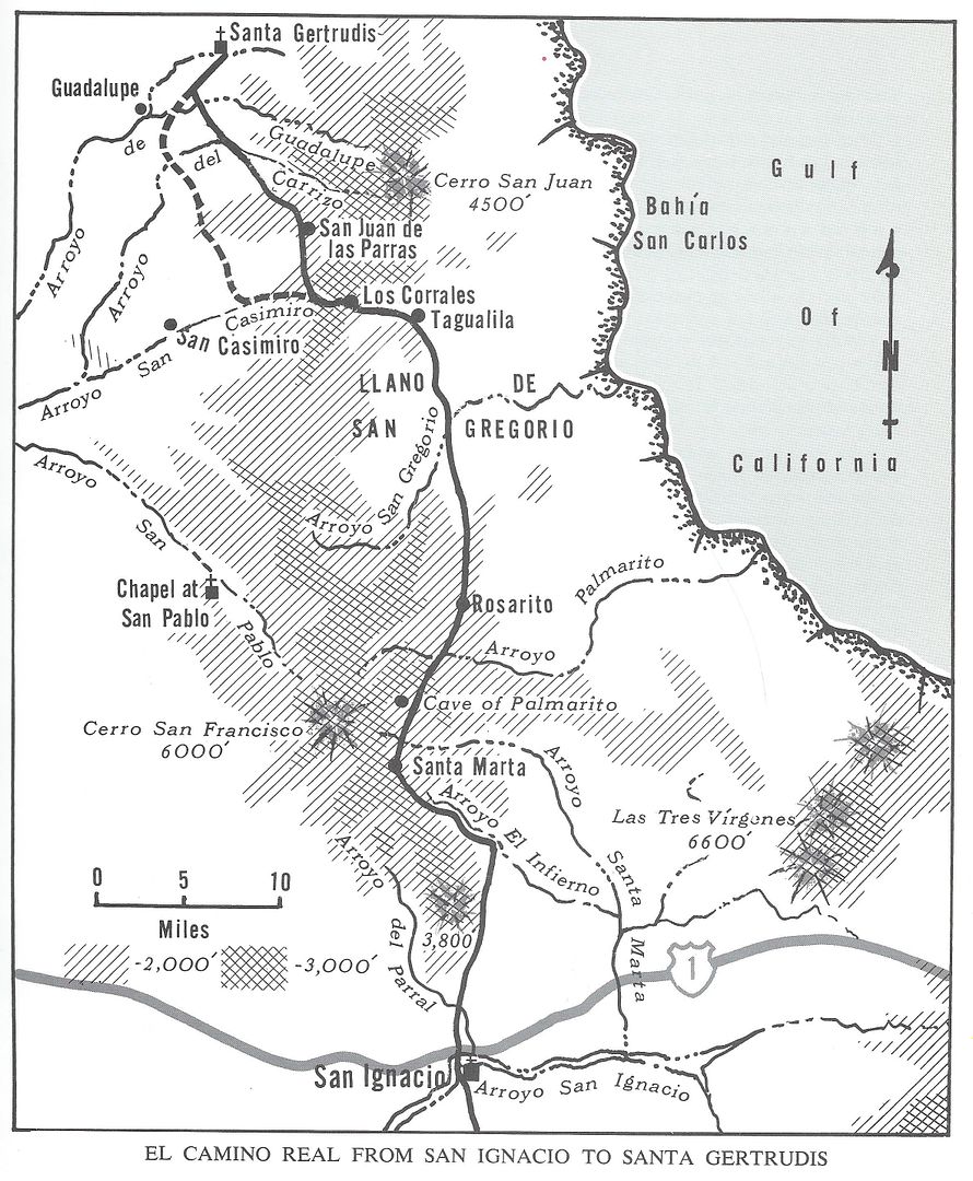
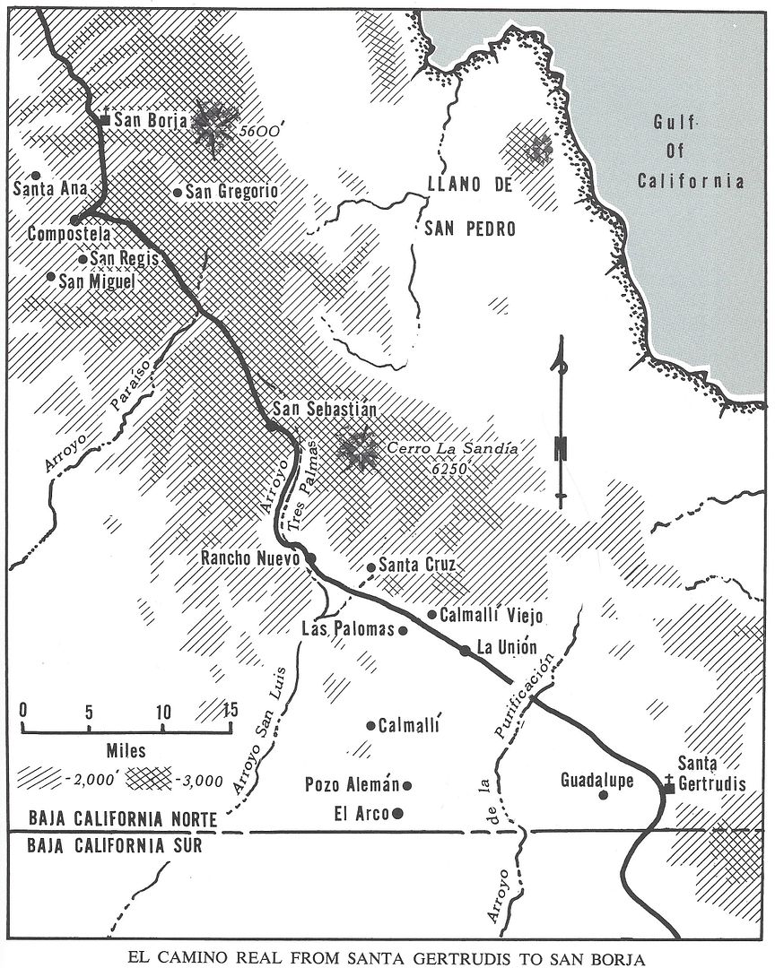
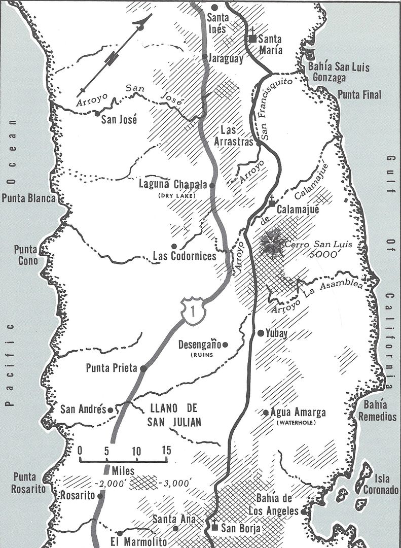
Here are Harry's 1974 ECR maps which may be the easiest for the casual ECR enthusiast to relate to:
|
|
|
4x4abc
Ultra Nomad
Posts: 4163
Registered: 4-24-2009
Location: La Paz, BCS
Member Is Offline
Mood: happy - always
|
|
Back to the very start of this thread.
In Gulick's notes he writes:
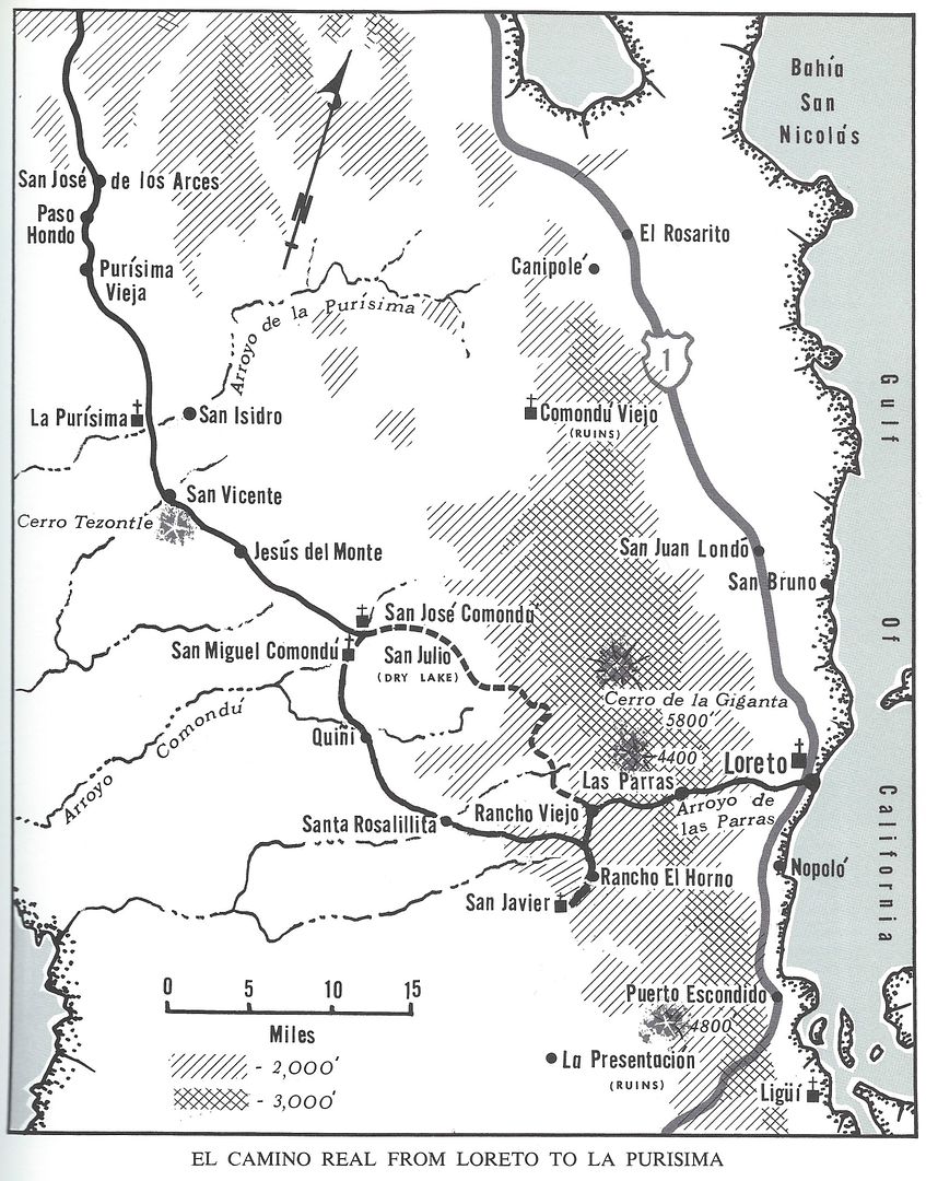
"In 1952 a road starting in Loreto went up the Cañon de Las Parras, past a little ranch called Cuevas Pintas, 9.2 miles from Loreto....."
No Cuevas Pintas in any map I have seen - is it Rancho La Venta?
Harald Pietschmann
|
|
|
| Pages:
1
2 |


