| Pages:
1
2
3
..
8 |
PaulW
Ultra Nomad

Posts: 3004
Registered: 5-21-2013
Member Is Offline
|
|
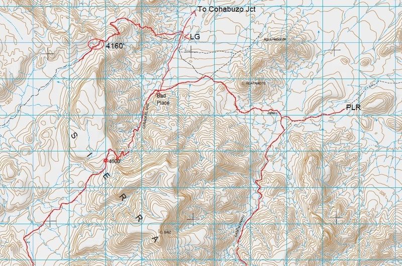
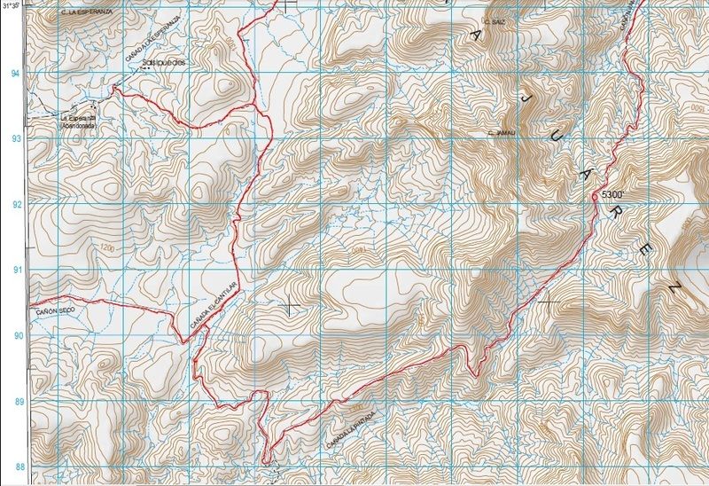
Three Summits Study
Summits
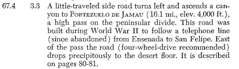
Summit #1) The 1962 edition of Gerhard & Gulick's Lower California Guidebook (where we all learned about the Pole Line Road) makes it clear that
after crossing Arroyo El Saiz that a spectacularly steep climb the pole line road arrives at the Portezuelo de Jamau at 4000 (actual 4160, 1268m).
Coords are N31 37.63, W115 6.624. This summit is commonly known as the Race summit. After the summit the road enters the upper Canon el Alamito then
on to Hwy 3 by way of Nuevo Junction.
Summit #2) At a location near the famous locked gate is Canada el Saiz. This track is shown on the map and goes thru the fence gate near the lock
gate and is used as the bypass of the lock gate. This track has a very steep place that consists of loose dirt and loose rocks and is very steep and
would challenge any 4wd vehicle, and even a bike. It was a difficult hike to its top of the hard place where the track beyond looks to be easier. The
track goes to its summit Saiz Summit at elevation of 4660 (1411m). Coordinates are n31 35.955, w115 36.495. This summit is commonly known as the
Middle Summit. After the summit the track enters into Canada Cantilar where it meets the road at the same place as does Summit 3
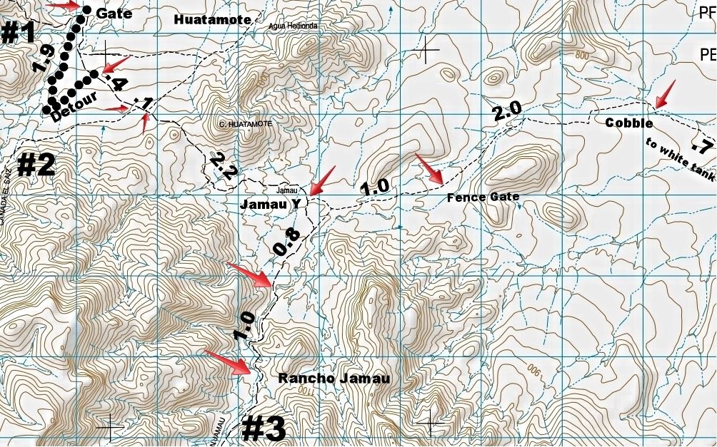
Summit #3) After passing the white tank heading west across the plateau the PLR comes to the place called Jamau where Canon Jamau can be followed to
its summit at elevation 5300(1610m). This has historically been called the South Summit or Jamau Summit. Coords are N31 33.399, W115 34.533. At this
point the map shows an existing road rather than a dashed line track. The road follows Canada la Pintada, then crosses Canada la Carrizo to arrive at
Canon la Cantilar where the Saiz summit track and the Jamau road join, then on to the road to Canon Seco.
= = = =
1962 map of the Pole Line Road by Howard Gulick (Lower California Guidebook)...
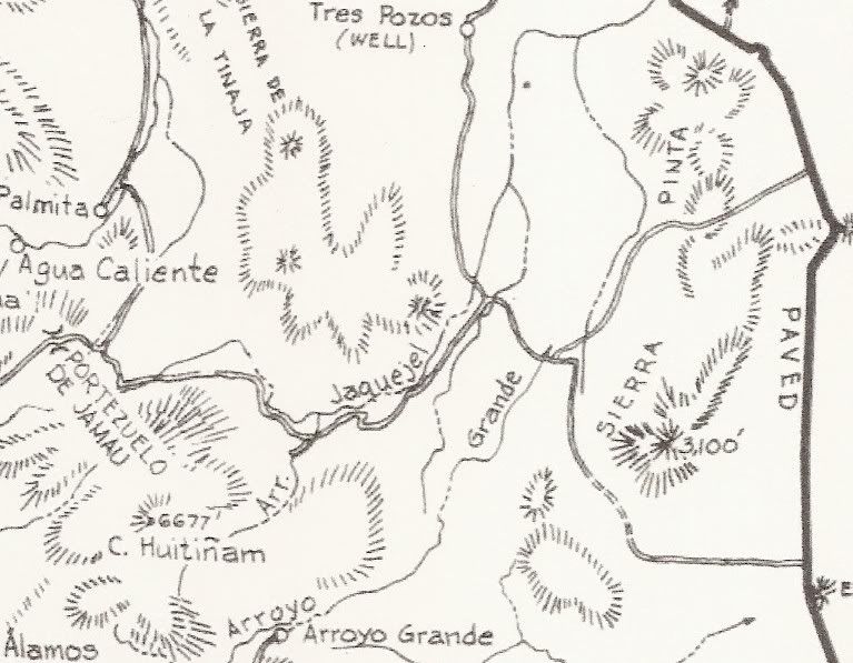
= = = =
North image
South Image
It was Neal Johns who got curious while reading the Lower California Guidebook...
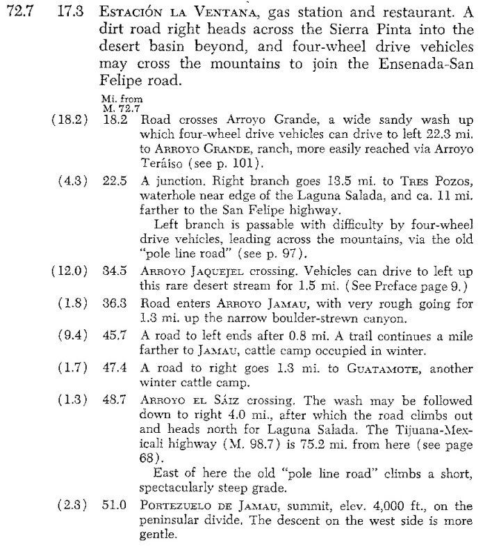
Here is the page with the road from La Ventana on Hwy. 5, west to the Pole Line Road, then following it west to the summit:
|
|
|
TMW
Select Nomad
Posts: 10659
Registered: 9-1-2003
Location: Bakersfield, CA
Member Is Offline
|
|
Back in the early 90s we rode our MCs from the jct with the PLR Y toward the 3rd summit but as I remember the road ended at an arroyo with a steep
drop off not far from the Y. Google Earth and Bing are not clear in the area near the PLR. It would be interesting to go there and see what the
conditions are now.
|
|
|
PaulW
Ultra Nomad
Posts: 3004
Registered: 5-21-2013
Member Is Offline
|
|
Yes. I should clarify.
Go up Canon Jamau and see if there is an alternate for your drop off. That is what we did for the lock gate go around. In the case of Saiz the hike
was easy. Dont know what will be found up Canon Jamau. The topo shows the road ending a little north of its summit then a trail after that.
The hill at the hard turn used for the lock gate bypass in Saiz also has a hard has place that a 4wd rig will have trouble with, On your moto it will
be a typical loose soil/rock hill climb that will make it possible. Of course going down would not be an issue. The topo makes no suggestion that the
Saiz summit is passable following the shown trail. No road shown like Jamau.
Having said all the above from the early 90s lots of weather has happened. We have experienced un- drivable places that suddenly become drivable and
the opposite. Passable and unpassable varies quite a bit. Anyway for an adventure its worth a try rancher cooperation is an issue between summits
and hwy 3.
Reminds me of the mini summit that is un-drivable and two of my buddies have done that trip recently on motos going east. They both said going down
the drop off was a typical deal on the bike. Just a hold their breath drop off. Precise tire placement makes it work on a bike.
Paul
[Edited on 4-22-2015 by PaulW]
|
|
|
Mexitron
Ultra Nomad
Posts: 3397
Registered: 9-21-2003
Location: Fort Worth, Texas
Member Is Offline
Mood: Happy!
|
|
We saw the 3rd summit road a couple years ago and took the Y you are describing to find it and if that road ever connected it has long since been
washed out going across the arroyo.
|
|
|
David K
Honored Nomad
Posts: 64476
Registered: 8-30-2002
Location: San Diego County
Member Is Offline
Mood: Have Baja Fever
|
|
I need to call the Squarecircle, who I recall told me about the 3rd summit road.
North to South:
1) Original Summit, Pole Line Road, 'Portezuelo de Jamau' (visible from Pole Line Road below and on Google Earth)
2) Cañada el Sáiz Summit Road (this is just south of #1, and easily visible from PLR below and on Google Earth). This seems to me the main route used
by Rancho Huatamote (Guatamote).
3) Cañon Jamau Summit Road, on INEGI map but not complete to the bottom on Google Earth. This goes from the 'Left at Y' on the PLR via Rancho Jamau
(abandoned?) up the mountain.
[Edited on 5-24-2015 by David K]
|
|
|
TMW
Select Nomad
Posts: 10659
Registered: 9-1-2003
Location: Bakersfield, CA
Member Is Offline
|
|
Summit #2 was marked by SCORE for use in a Baja 500 race in the mid 90s. The course would go over Summit #1 and return over Summit #2 then down the
Goat Trail and over to Mikes Sky Ranch. A lot of the car guys complained so much about how rough it was that Sal changed the course and bypassed both
summits.
My brother and I pre-ran the course over both summits in my 93 Toyota 4x4. Later that year two friends and I went down Summit #2 camped, I was in my
Toyota and they on MCs. The next day we all rode MC up and over Summit #1 west to east and around and over Summit #2. I was on a Honda CT110 and
coming down Summit #2 was a wild ride, I ended up bull-dogging the bike down.
|
|
|
David K
Honored Nomad
Posts: 64476
Registered: 8-30-2002
Location: San Diego County
Member Is Offline
Mood: Have Baja Fever
|
|
So the question is, when was Summit #3 passable? It is shown on INEGI map as a regular road (no surprise as their maps are far from accurate)? As I
said, I think Roy (the Squarecircle) told me he drove it... not surprised, as (with TMW's help) he drove the La Turquesa Grade!
[Edited on 4-22-2015 by David K]
|
|
|
PaulW
Ultra Nomad
Posts: 3004
Registered: 5-21-2013
Member Is Offline
|
|
Which race? Maybe the 95 500?
PW
====
Quote: Originally posted by TMW  | Summit #2 was marked by SCORE for use in a Baja 500 race in the mid 90s. The course would go over Summit #1 and return over Summit #2 then down the
Goat Trail and over to Mikes Sky Ranch. A lot of the car guys complained so much about how rough it was that Sal changed the course and bypassed both
summits.
My brother and I pre-ran the course over both summits in my 93 Toyota 4x4. Later that year two friends and I went down Summit #2 camped, I was in my
Toyota and they on MCs. The next day we all rode MC up and over Summit #1 west to east and around and over Summit #2. I was on a Honda CT110 and
coming down Summit #2 was a wild ride, I ended up bull-dogging the bike down. |
|
|
|
TMW
Select Nomad
Posts: 10659
Registered: 9-1-2003
Location: Bakersfield, CA
Member Is Offline
|
|
Paul I'm pretty sure it was the 95 but could have been 96. One of those years it went north into the pine forest and down the La Rumorosa grade. While
in the pine forest the Simon and Simon truck caught fire.
|
|
|
TMW
Select Nomad
Posts: 10659
Registered: 9-1-2003
Location: Bakersfield, CA
Member Is Offline
|
|
I emailed Tim Morton to see if he can shed some light on this summit #3. Sound to me like a Summit Hunting Trip may be in the works. Get the
Squarecircle (Roy) to fire up that Range Rover.
As a side note: a couple of years ago my friend BJ and I was on the road shown on the south image map above by Paul and at the very bottom there is a
dash line going further down off the page. BJ and I drove that road and it makes a circle around to a large field where it ends and there was a
crashed airplane. At the time the engine was missing and I think the wings were gone. This was probably 2005 or 2006. I remember a road to the left
which was probably the road to summit #3. At the time we thought it may have been the other end of the road we were on making a complete circle. But
where we ended we drove around and never saw our road going any further.
|
|
|
TMW
Select Nomad
Posts: 10659
Registered: 9-1-2003
Location: Bakersfield, CA
Member Is Offline
|
|
Tim was not aware of a third summit south of the race summit.
|
|
|
PaulW
Ultra Nomad
Posts: 3004
Registered: 5-21-2013
Member Is Offline
|
|
During the time frame when the road book for the Code/Norra was being built the 3 summit subject came up. We were told about a Score race that used
two of the summits. We gave up on finding the other summits because of lack of details and no time to go drive to find them. We sure do have better
info now.
The 95 500 map on Murdock shows a loop from El Alamo to Valley Trinidad.
Lots of roads close to and north of Hwy 3 to make driving pretty complicated. Some local help would be great.
|
|
|
TMW
Select Nomad
Posts: 10659
Registered: 9-1-2003
Location: Bakersfield, CA
Member Is Offline
|
|
Paul it was the 95 500 race. I'll look to see if I can find the original map using the two summits. The Murdock map is what the race was changed to.
Here is the notes I made on the 2 summit loop when I drove it in December 2004.
Summit Loop
For reference use the Baja Almanac page 8.
On hwy 3 turn north at KM108. Youll cross a cattle guard onto a graded road.
GPS readings are Datum 27 in degrees-minutes seconds, followed by elevation.
Hwy 3 at KM108. 0.0 31-29-29 x 115-46-39 3514ft
Jct. Sign Jamau y Sonora 2.8 31-29-55 x 115-43-59 3339ft
Bear left.
Nuevo jct. turn off to left 3.6 31-30-26 x 115-43-41 3350ft
Continue straight
At this point youll go about 6 miles total looking for a road to the left. If you come to a locked gate turn around and go back looking for a road to
your right with in a mile. Im going from memory so please bear with me. If you look straight ahead you can see the summit road running left to right
at the base of the mtns.
The turn off road will take you to the summit road access at 6.9 miles from hwy.
Summit road access 6.9 31-33-09 x 115-43-31 3484ft
Fence and cattle guard 9.7 31-34-55 x 115-43-05 3736ft
This starts Summit run.
Sum. Rd .2 miles pass Dam 12.1 31-35-24 x 115-41-07 3761ft
Wash near house 14.2 31-35-49 x 115-39-49 3787ft
Note. This is El Jamau on topo map
** Top of Summit 19.0 31-37-38 x 115-36-37 4186ft
Wash at bottom of Summit 20.7 31-37-57 x 115-36-09 3088ft
Note: Turn right up out of wash. Watch carefully.
You can see road to south coming down Summit.
Turn right for South Summit 21.8 31-37-07 x 115-34-48 3220ft
Hill top up South Summit 24.1 31-36-10 x 115-36-04 4033ft
** Top of South Summit 24.6 31-36-03 x 115-36-24 4588ft
Gate at top of South Summit 25.0 31-35-52 x 115-36-31 4639ft
Y in road bear right 28.7 31-34-03 x 115-37-41 4448ft
Y in road bear right 31.0 31-32-21 x 115-38-19 3829ft
Note: Your now on Graded
Road to village of Jamau.
Cattle gate 32.9
Cattle gate 33.4
Jct. Sign Jamau y Sonora, same as line two above.
For Ref. Cohabuso Jct. 31-55-44 x 115-36-17 @ 952ft
|
|
|
PaulW
Ultra Nomad
Posts: 3004
Registered: 5-21-2013
Member Is Offline
|
|
Ha - I knew you were the guy
So the jeep is apart so It will be a while before Ican digest the info below
Thanks for your input.
Paul
=======
| Quote: Originally posted by TMW | Paul it was the 95 500 race. I'll look to see if I can find the original map using the two summits. The Murdock map is what the race was changed to.
Here is the notes I made on the 2 summit loop when I drove it in December 2004.
Summit Loop
For reference use the Baja Almanac page 8.
On hwy 3 turn north at KM108. Youll cross a cattle guard onto a graded road.
GPS readings are Datum 27 in degrees-minutes seconds, followed by elevation.
Hwy 3 at KM108. 0.0 31-29-29 x 115-46-39 3514ft
Jct. Sign Jamau y Sonora 2.8 31-29-55 x 115-43-59 3339ft
Bear left.
Nuevo jct. turn off to left 3.6 31-30-26 x 115-43-41 3350ft
Continue straight
At this point youll go about 6 miles total looking for a road to the left. If you come to a locked gate turn around and go back looking for a road to
your right with in a mile. Im going from memory so please bear with me. If you look straight ahead you can see the summit road running left to right
at the base of the mtns.
The turn off road will take you to the summit road access at 6.9 miles from hwy.
Summit road access 6.9 31-33-09 x 115-43-31 3484ft
Fence and cattle guard 9.7 31-34-55 x 115-43-05 3736ft
This starts Summit run.
Sum. Rd .2 miles pass Dam 12.1 31-35-24 x 115-41-07 3761ft
Wash near house 14.2 31-35-49 x 115-39-49 3787ft
Note. This is El Jamau on topo map
** Top of Summit 19.0 31-37-38 x 115-36-37 4186ft
Wash at bottom of Summit 20.7 31-37-57 x 115-36-09 3088ft
Note: Turn right up out of wash. Watch carefully.
You can see road to south coming down Summit.
Turn right for South Summit 21.8 31-37-07 x 115-34-48 3220ft
Hill top up South Summit 24.1 31-36-10 x 115-36-04 4033ft
** Top of South Summit 24.6 31-36-03 x 115-36-24 4588ft
Gate at top of South Summit 25.0 31-35-52 x 115-36-31 4639ft
Y in road bear right 28.7 31-34-03 x 115-37-41 4448ft
Y in road bear right 31.0 31-32-21 x 115-38-19 3829ft
Note: Your now on Graded
Road to village of Jamau.
Cattle gate 32.9
Cattle gate 33.4
Jct. Sign Jamau y Sonora, same as line two above.
For Ref. Cohabuso Jct. 31-55-44 x 115-36-17 @ 952ft
|
|
|
|
Emerson
Junior Nomad
Posts: 42
Registered: 6-24-2013
Member Is Offline
|
|
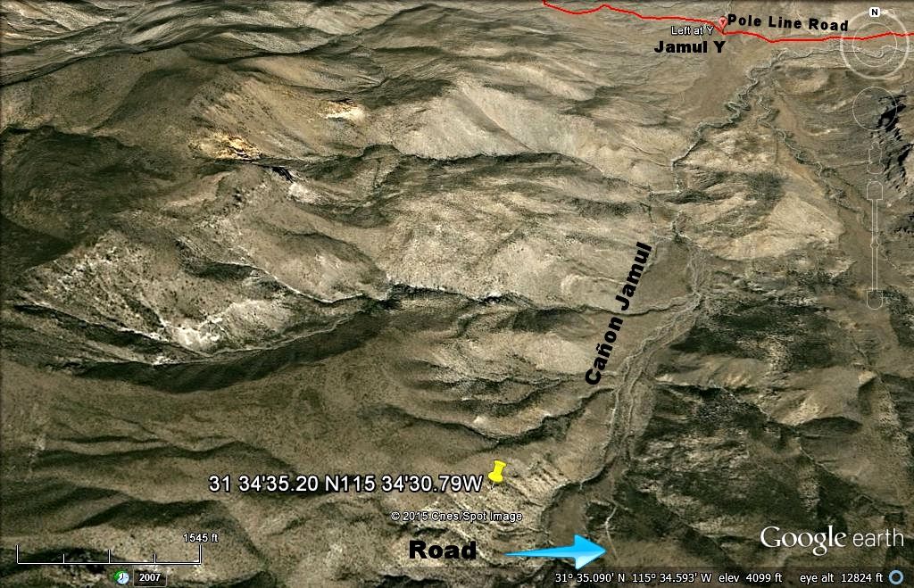
Have you looked at the road coming from and going to the top of this hill, can it be another summit route?:
31 34'35.20 N
115 34'30.79W
1610 meters in altitude.
Check it out...
|
|
|
David K
Honored Nomad
Posts: 64476
Registered: 8-30-2002
Location: San Diego County
Member Is Offline
Mood: Have Baja Fever
|
|
| Quote: Originally posted by Emerson | Have you looked at the road coming from and going to the top of this hill, can it be another summit route?:
31 34'35.20 N
115 34'30.79W
1610 meters in altitude.
Check it out... |
Hi Emerson, your waypoint is on the opposite side of the Cañon Jamul road... (see topo map above), yes?
|
|
|
PaulW
Ultra Nomad
Posts: 3004
Registered: 5-21-2013
Member Is Offline
|
|
Yup, correct.
Your Coords are close to the S Smt road. Good enough for me. You are correct. Your Coords are South of the S smt which is 5300'. It looks to be a good
road, However that road closer to Jamau disappears.
Paul
=========
| Quote: Originally posted by Emerson | Have you looked at the road coming from and going to the top of this hill, can it be another summit route?:
1610 meters in altitude.
Check it out... |
|
|
|
David K
Honored Nomad
Posts: 64476
Registered: 8-30-2002
Location: San Diego County
Member Is Offline
Mood: Have Baja Fever
|
|
I just got off the phone with The squarecircle (Roy), whom has been exploring the Pole Line Road and the summit roads since 1984. The Jamau Canyon
(3rd or southernmost) road was not passable when he with a group from Tierra del Sol investigated the canyon. From the top, the road becomes
impassable a few hundred feet before an area where a ranch may have once been. On the bottom end, coming up from the "Jamau Y" the road goes to an
abandoned ranch and then was washed out or overgrown beyond. So the gap we don't see a road on today, on Google Earth is correct, but it may have once
been a through road as the INEGI topo map shows?
|
|
|
TMW
Select Nomad
Posts: 10659
Registered: 9-1-2003
Location: Bakersfield, CA
Member Is Offline
|
|
We need to go down and check it out and see what is missing to make it a go road. I'm down south for the next week starting Sunday. Then I got the Lou
Peralta GP race May 15 & 16. After that I'm good to go. Get Roy and Richard and a few others and we could blaze a new trail. Maybe XRPhil too.
|
|
|
PaulW
Ultra Nomad
Posts: 3004
Registered: 5-21-2013
Member Is Offline
|
|
Can you use your bing expertise to see if there is anything the might be a road?
====
| Quote: Originally posted by David K | | I just got off the phone with The squarecircle (Roy), whom has been exploring the Pole Line Road and the summit roads since 1984. The Jamau Canyon
(3rd or southernmost) road was not passable when he with a group from Tierra del Sol investigated the canyon. From the top, the road becomes
impassable a few hundred feet before an area where a ranch may have once been. On the bottom end, coming up from the "Jamau Y" the road goes to an
abandoned ranch and then was washed out or overgrown beyond. So the gap we don't see a road on today, on Google Earth is correct, but it may have once
been a through road as the INEGI topo map shows? |
|
|
|
| Pages:
1
2
3
..
8 |


