| Pages:
1
2
3
4
5
..
8 |
David K
Honored Nomad

Posts: 64479
Registered: 8-30-2002
Location: San Diego County
Member Is Offline
Mood: Have Baja Fever
|
|
Quote: Originally posted by Emerson  | Wow, this thread is really nice... I wanna play too...
OK, so Google Earth and Bing pictures have been shown, let me add the ones from Apple Maps, with similar resolution as Bing.
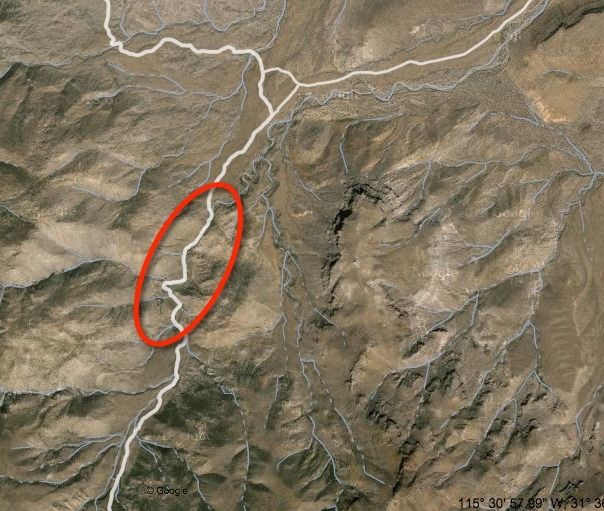
I measured the part without a clear visible road, it sums about 1.4km measured directly in the wash bed.
Altitude changes from 1040m to 970m (in the part without road).
Since theres no evidence of bypasses from the main wash bed, its possible that the original road in the wash itself.
....
Im leading a team on May 8th thru Laguna Salada, sleeping at the Isabel Canyon, and going up El Mano on Friday ending at Laguna Hanson, if the locked
gate is confirmed then we might have to re-route the trip.
Happy week to everyone!
Lets keep this Summit study alive!
-Emerson
|
Great to have more Baja 4WD explorers on board!
Squrecircle has been reading this and calling me to help contribute (has computer issues preventing him from posting).
Weather, time, and usage definitely change road conditions.
South of Hwy. 2 we have these roads from the summit of the Sierra Juarez to the desert floor:
A) El Mano
B) Portezuelo de Jamau (#1)
C) El Sáiz Canyon (#2)
D) Jamau Canyon (#3)
E) One or more roads from Valle de Trinidad to Arroyo Grande headwater area.
Roy said that #3 was called 'Cowboy Canyon' by his friend back in the '80s when they found the Pole Line Road and explored the area... but it was not
passable to the top then. (I hope I got this right, as we talked about other things so I may need to correct this)
[Edited on 4-1-2019 by David K]
|
|
|
PaulW
Ultra Nomad
Posts: 3005
Registered: 5-21-2013
Member Is Offline
|
|
For completeness let me say
Another summit can be found between San Matias and Arroyo Grande I am sure it will pass thru the Indian village and then dead end somewhere along the
way. The gates that Harald found will be at the east end if one can get that far. Roads/trails are visible on GE so one could make some tracks to
follow. Lots of options on the N side to deal with all the farm plots.
Paul
|
|
|
Emerson
Junior Nomad
Posts: 42
Registered: 6-24-2013
Member Is Offline
|
|
| Quote: Originally posted by PaulW | For completeness let me say
Another summit can be found between San Matias and Arroyo Grande I am sure it will pass thru the Indian village and then dead end somewhere along the
way. The gates that Harald found will be at the east end if one can get that far. Roads/trails are visible on GE so one could make some tracks to
follow. Lots of options on the N side to deal with all the farm plots.
Paul |
Hi Paul, yes, you are right, there are some trails South-East from Summit #3, but I spent a couple of hours looking for a road that climbed down to
the north side desert floor and near the PLR, and I was not successful, there either dead ends or they connect back to the main road that gets you
into Arroyo Grande.
It almost looks like the someone can travel from Arroyo Grande ranch cross all the mountains west up to Santa Catarina, somehow parallel to the main
Hwy3; but only summits 1 thru 3, and the Arroyo Grande trail can get you all the way down into the northern desert floor.
-Emerson.
|
|
|
David K
Honored Nomad
Posts: 64479
Registered: 8-30-2002
Location: San Diego County
Member Is Offline
Mood: Have Baja Fever
|
|
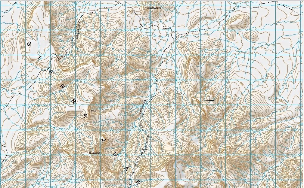
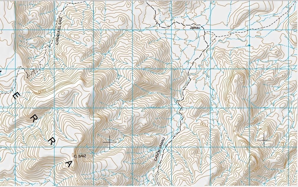
We hope to have a close up view of #3 to see if it is indeed washed out or if it looks like it did go through at one time, as the INEGI map shows.
|
|
|
PaulW
Ultra Nomad
Posts: 3005
Registered: 5-21-2013
Member Is Offline
|
|
Looks like a rock craw rig will be needed to cross the wash. And hard to see what is on the west side above the wash.
Answer is to drive there.
=====
| Quote: Originally posted by David K | | We hope to have a close up view of #3 to see if it is indeed washed out or if it looks like it did go through at one time, as the INEGI map shows.
|
|
|
|
PaulW
Ultra Nomad
Posts: 3005
Registered: 5-21-2013
Member Is Offline
|
|
Land marks in that region From and old INEGI Datum 27 map not in my position.
Arroyo Taraiso is a canyon on the west at 31 22.48, 115 28.39
La Estaca (Ab) in in canyon Taraiso at 31 22.45, 115 28.39
The road past Estaca in canyon Traraiso leads over the mountains and arrives to a complex of roads west of San Matias. At Hyw3 the WPs are S Matias 1
& 2. WPSM1 is at 31 21.126, 115 36.601 and WPSM2 is 31 21.786, 115 38.776
El Taraisco (Ab) is in the main canyon at 31 22.2, 115 28.12
Santa Fe (Ab) in the main canyon is at 31 21.59, 115 27.61
Side canyon with road is at 31 21.41, 115 27.54
La Morita (Ab) and side canyon leading NE is at 31 19.85, 115 26.21
You all can get a head start. Later I will convert and find them on GE and the latest topo
Paul
=======
| Quote: Originally posted by Emerson | | Quote: Originally posted by PaulW | For completeness let me say
Another summit can be found between San Matias and Arroyo Grande I am sure it will pass thru the Indian village and then dead end somewhere along the
way. The gates that Harald found will be at the east end if one can get that far. Roads/trails are visible on GE so one could make some tracks to
follow. Lots of options on the N side to deal with all the farm plots.
Paul |
Hi Paul, yes, you are right, there are some trails South-East from Summit #3, but I spent a couple of hours looking for a road that climbed down to
the north side desert floor and near the PLR, and I was not successful, there either dead ends or they connect back to the main road that gets you
into Arroyo Grande.
It almost looks like the someone can travel from Arroyo Grande ranch cross all the mountains west up to Santa Catarina, somehow parallel to the main
Hwy3; but only summits 1 thru 3, and the Arroyo Grande trail can get you all the way down into the northern desert floor.
-Emerson. |
|
|
|
Emerson
Junior Nomad
Posts: 42
Registered: 6-24-2013
Member Is Offline
|
|
David, what INEGI app are you using?
I quickly searched in their interactive map app, and added GE layers with the roads in their archive and seems the original (at least according to
INEGI) does run into the wash in the section in question.
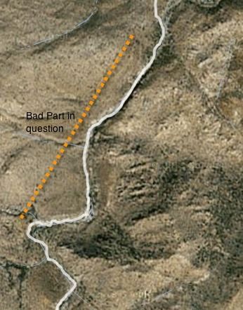
Heres a zoom out from the #3 Summit with the white road from INEGI reference.
And here is the zoom in on the unknown part of the trail.
So when are we visiting the area?
|
|
|
4x4abc
Ultra Nomad
Posts: 4163
Registered: 4-24-2009
Location: La Paz, BCS
Member Is Offline
Mood: happy - always
|
|
Paul, the spots you described are no longer accessible due to locked gates.
Harald Pietschmann
|
|
|
4x4abc
Ultra Nomad
Posts: 4163
Registered: 4-24-2009
Location: La Paz, BCS
Member Is Offline
Mood: happy - always
|
|
I have done all the roads and trails east of the summits (west of Arr Grande)
one of them is particularly interesting as it leads into Cañon Jaquegel
with a little trail work one could make a new connection to PLR
Harald Pietschmann
|
|
|
4x4abc
Ultra Nomad
Posts: 4163
Registered: 4-24-2009
Location: La Paz, BCS
Member Is Offline
Mood: happy - always
|
|
here is the new road to get into Arroyo Grande from the west
Harald Pietschmann
|
|
|
Mexitron
Ultra Nomad
Posts: 3397
Registered: 9-21-2003
Location: Fort Worth, Texas
Member Is Offline
Mood: Happy!
|
|
| Quote: Originally posted by Emerson | David, what INEGI app are you using?
I quickly searched in their interactive map app, and added GE layers with the roads in their archive and seems the original (at least according to
INEGI) does run into the wash in the section in question.
Heres a zoom out from the #3 Summit with the white road from INEGI reference.
And here is the zoom in on the unknown part of the trail.
So when are we visiting the area? |
Looked through my pics but I didn't take any of this section, though we did visit it and it looked very washed out...we couldn't see any way through.
I was kind of glad since the road up the canyon in the distance looked really steep and we probably would have had to investigate it  Unfortunately Brooks (Taco de Baja) or his sister Libby might have taken some pics but
they are on a family vacation in France for a couple weeks. Unfortunately Brooks (Taco de Baja) or his sister Libby might have taken some pics but
they are on a family vacation in France for a couple weeks.
|
|
|
David K
Honored Nomad
Posts: 64479
Registered: 8-30-2002
Location: San Diego County
Member Is Offline
Mood: Have Baja Fever
|
|
| Quote: Originally posted by Emerson | David, what INEGI app are you using?
I quickly searched in their interactive map app, and added GE layers with the roads in their archive and seems the original (at least according to
INEGI) does run into the wash in the section in question.
...
So when are we visiting the area? |
Hi Emerson,
H11B25 2003 edition...
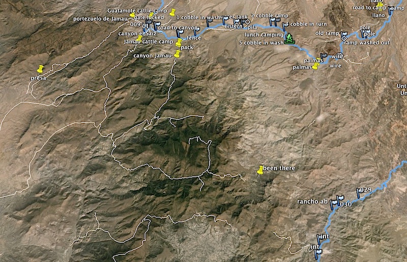
ZOOM IN on the area of interest:
Going down the canyon the major dirt road (pair of solid lines, white inside) turns into a medium dirt road (big dashes)... the Pole Line Road east of
the Jamau Y Junction is shown as a minor dirt road (small dashes).
|
|
|
Emerson
Junior Nomad
Posts: 42
Registered: 6-24-2013
Member Is Offline
|
|
| Quote: Originally posted by 4x4abc | I have done all the roads and trails east of the summits (west of Arr Grande)
one of them is particularly interesting as it leads into Cañon Jaquegel
with a little trail work one could make a new connection to PLR
|
Thanks Harald, so, can you confirm the one "interesting" trail that leads into Canon Jaquegel is passable? Im assuming is the one marked with a marker
called "canyon jamau".
From your image I cant really tell if the line representing the trail is connected down all the way down to the PLR.
And in a side comment, WOW, thats a lot of trail exploring in that area based on your map, I cant imagine what the rest of the areas look like with
all the exploring under your belt. Cool!
-Emerson
|
|
|
David K
Honored Nomad
Posts: 64479
Registered: 8-30-2002
Location: San Diego County
Member Is Offline
Mood: Have Baja Fever
|
|
Harald, are the white lines roads you marked on GE, or roads you have driven on? I ask, because the road in Cañon Jamau (Summit #3) is shown and we
are asking for input from anyone who has been in there since Roy's trip in 1983.
|
|
|
4x4abc
Ultra Nomad
Posts: 4163
Registered: 4-24-2009
Location: La Paz, BCS
Member Is Offline
Mood: happy - always
|
|
David,
in the image above the white lines are generated in GE, but I have driven them at one point in the last 20 years.
The section in Jamau below the new road and the trail coming up from PLR is not passable (yet).
The marker "been there" shows how far I had gotten into the valley that drains into Jaquegel. I was more than 10 years ago. Ran into a group of
surveyors on mules. They were correcting mapping mistakes, as they said. They were very surprised to see us so far out.
By the way, we had come up Cañon Saiz.
Harald Pietschmann
|
|
|
David K
Honored Nomad
Posts: 64479
Registered: 8-30-2002
Location: San Diego County
Member Is Offline
Mood: Have Baja Fever
|
|
Baja is such a great place to explore, thanks to the dirt roads and beautiful desert, and history everywhere there!
|
|
|
Mexitron
Ultra Nomad
Posts: 3397
Registered: 9-21-2003
Location: Fort Worth, Texas
Member Is Offline
Mood: Happy!
|
|
| Quote: Originally posted by David K | | Baja is such a great place to explore, thanks to the dirt roads and beautiful desert, and history everywhere there! |
Like.
|
|
|
PaulW
Ultra Nomad
Posts: 3005
Registered: 5-21-2013
Member Is Offline
|
|
| Quote: Originally posted by 4x4abc |
I have done all the roads and trails east of the summits (west of Arr Grande)
one of them is particularly interesting as it leads into Cañon Jaquegel
with a little trail work one could make a new connection to PLR
|
= = = =
You also said:
Paul, let me know if you need tracks - I have a few
Harald Pietschmann
====
My reply is I want to drive all those roads in your image above and that means I need a GPS track. I can make the tracks from your GE file or you can
send them to me. Any GPS format will work.
Thanks, Paul
|
|
|
4x4abc
Ultra Nomad
Posts: 4163
Registered: 4-24-2009
Location: La Paz, BCS
Member Is Offline
Mood: happy - always
|
|
some in that area:
PLRarea
Harald Pietschmann
|
|
|
GonzagaBayMan
Newbie
Posts: 4
Registered: 5-14-2014
Location: On the Bay
Member Is Offline
|
|
More History on Summit Route
Just some more history: The Summit and the Jamau wash were explored and completed out to La Venatna by myself and 4 other members of the Los Ancianos
Motor Cycle Club (Founded in 1960 and still active in Baja) of San Diego late 1963 and 1964.
We used information discussed earlier in this post to find the route under the leadership of our President and head explorer Bill Steider. It was very
difficult. Remnants of the pole line were still visible at that time and the wash was very difficult to ride even headed down the wash as I remember
it, and we literally had to work together to lift these very heavy bikes (Triumphs, Matchless and AJS) over many boulders and other obsatcles, we were
in the ash for over 5 hours and it was hot. The exit out of the wash was very technical and it took several attempts by each rider.
The planned one day trip starting out on the El Compadre Road out side of Tecate to San Felipe turned into two days with a dry overnight campout
without camping gear extra food and water. Two of the bikes ran out of fuel and needed to be pushed (foot into the rear shock) into La Ventana where
we found gas and Balogna sandwiches. The route was then used later for the famous and very difficult Los Ancianos Tecate 500 Enduro in 1971and 1972
from Tecate to San Felipe and back via the summit and the Jamau wash and Arroyo Grande to Diablo Dry Lake and onto San Felipe .Later, SCORE and
others used parts of the route for their events. That what I know.
|
|
|
| Pages:
1
2
3
4
5
..
8 |


