Billyberoux
Newbie
Posts: 1
Registered: 4-23-2015
Member Is Offline
|
|
Guadalupe cnyn south route to San Felipe
Does anyone have/know of a GPS track for an off road route from Guadalupe Canyon heading south to connect with Mexico 5 Hwy at or about KM 87 to
continue on to San Felipe?
I have a high clearance Jeep Wrangler but I will most likely be the only vehicle going and would appreciate advice or recent update on that route.
Thank you,
Bill
|
|
|
David K
Honored Nomad

Posts: 65562
Registered: 8-30-2002
Location: San Diego County
Member Is Offline
Mood: Have Baja Fever
|
|
MICK and another vehicle went that way over last Easter, John M went back out that way with them in case MICK needed a tow. We met them at Cohabuzo
Junction, which is where the cross-over road from Hwy. 5 (at the sand dunes) meets the north/south road, south of Guadalupe Canyon.
I drove it way back in 2002 and posted a few GPS waypoints on my VivaBaja.com GPS page, if that helps until someone can provide a track. Google Earth
may be the answer as you can see the road and get GPS points along the way or make a map.
Let me know if I can be of any further assistance.
|
|
|
John M
Super Nomad
Posts: 1924
Registered: 9-3-2003
Location: California High Desert
Member Is Offline
|
|
GPS of the route
I can put one together I think. I have the Guadalupe to Cohabuzzo Junction already and I can try to upload the Cohabuzzo to Highway 5 from my in car
GPS.
There was nothing of any consequence to be concerned with as far as the condition of the roads. As David said, I drove it on April 5th.
Obviously the concern is with the unexpected situation with a single vehicle. There was an occupied ranch about 8 miles before reaching Highway 5. If
I can upload the track I'll mark the ranch.
Bill, on the top right of the screen, across from "Baja Nomad" is a clickable option for U2U - I used it to send you a private message, click on where
it'll say "you have one u2u message" - read it, if you want to reply, go down to the drop down menu, click "reply" and send it to me.
John M
[Edited on 4-23-2015 by John M]
|
|
|
David K
Honored Nomad
Posts: 65562
Registered: 8-30-2002
Location: San Diego County
Member Is Offline
Mood: Have Baja Fever
|
|
Quote: Originally posted by John M  | I can put one together I think. I have the Guadalupe to Cohabuzzo Junction already and I can try to upload the Cohabuzzo to Highway 5 from my in car
GPS.
There was nothing of any consequence to be concerned with as far as the condition of the roads. As David said, I drove it on April 5th.
Obviously the concern is with the unexpected situation with a single vehicle. There was an occupied ranch about 8 miles before reaching Highway 5. If
I can upload the track I'll mark the ranch.
Bill, on the top right of the screen, across from "Baja Nomad" is a clickable option for U2U - I used it to send you a private message, click on where
it'll say "you have one u2u message" - read it, if you want to reply, go down to the drop down menu, click "reply" and send it to me.
John M
[Edited on 4-23-2015 by John M] |
If you need help posting a track map or waypoints, let me know.
Here are the waypoints I recorded a dozen years ago when I crossed from Hwy. 5 to Guadalupe Canyon via Cohabuzo Jcn. (note the GPS is set at NAD27,
but it is pretty close to WGS84):
Going south and east:
Guadalupe Canyon access via Laguna Salada Dry Lake Rd. @ Mex.#2 (south turn, next 5 waypoints): 32°34.57'/ 115°44.63'
Jcn. Graded road & south end of Dry Lake road: 32°13.06'/ 115°42.24
Guadalupe Canyon Entrance: 32°09.40'/ 115°47.29'
Cohabuzo Jcn: 31°55.74'/ 115°36.22' (Turn left/ east for next 2 waypoints)
Ej. Saldaña Road (S): 31°50.12'/ 115°19.47'
Hwy. 5 & Ej. Saldaña Jcn: 31°51.75'/ 115°10.92'
|
|
|
John M
Super Nomad
Posts: 1924
Registered: 9-3-2003
Location: California High Desert
Member Is Offline
|
|
help not needed........yet David
It's just a matter of getting it off my Lowrance in the truck. I'll do that later today or tomorrow. Thanks for the offer. I believe I marked over a
dozen waypoints on our drive out a couple of weeks ago. Probably more current as we know the route changes sometimes. John
|
|
|
TMW
Select Nomad
Posts: 10659
Registered: 9-1-2003
Location: Bakersfield, CA
Member Is Offline
|
|
If you go to the CODE web site at http://codeoffroad.com.mx/
On the right side go down to the Race Ready 275 race and click on it. Then on the upper right click on GPS maps. It will give you a USR GPS. for the
2014 race from Hwy 2 at Laguna Salada to San Felipe. You can then convert it a Garmin GPS or Google Earth at
http://www.gpsvisualizer.com/
They did not come out to KM87 on Hwy 5 but further down around KM90. If you look at Google Earth it is easy to see where to turn east for KM87 at Hwy
5.
|
|
|
nunaddict
Newbie
Posts: 1
Registered: 11-16-2015
Member Is Offline
|
|
Any confirmation on the road south?
Friends of mine and I are going to be riding motorcycles down the third week of December. Planning on stopping at Canyon de Guadalupe but haven't
seen any confirmation on the road south to San Felipe. Our range with our stock tanks is about 200miles so it's play it safe or risk a ride south
unconfirmed.
Anyone able to save us a few hours backtracking north then going south?
|
|
|
StuckSucks
Super Nomad
Posts: 2376
Registered: 10-17-2013
Location: Pacific Plate
Member Is Offline
|
|
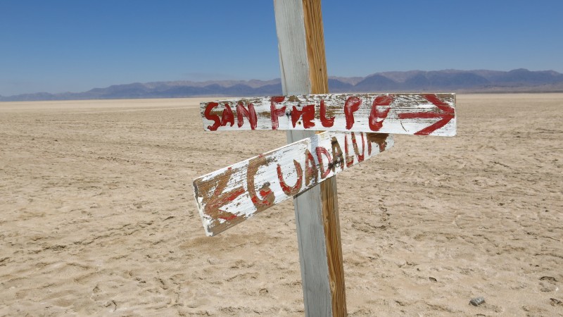
Watch for the helpful signage on Laguna Salada:
|
|
|
AKgringo
Elite Nomad
Posts: 6358
Registered: 9-20-2014
Location: Anchorage, AK (no mas!)
Member Is Offline
Mood: Retireded
|
|
Coming soon ....an Oxxo at the San Felipe/Guadelupe junction!
If you are not living on the edge, you are taking up too much space!
"Could do better if he tried!" Report card comments from most of my grade school teachers. Sadly, still true!
|
|
|
David K
Honored Nomad
Posts: 65562
Registered: 8-30-2002
Location: San Diego County
Member Is Offline
Mood: Have Baja Fever
|
|
| Quote: Originally posted by nunaddict | Friends of mine and I are going to be riding motorcycles down the third week of December. Planning on stopping at Canyon de Guadalupe but haven't
seen any confirmation on the road south to San Felipe. Our range with our stock tanks is about 200miles so it's play it safe or risk a ride south
unconfirmed.
Anyone able to save us a few hours backtracking north then going south? |
Off road m/c's should be easy stuff... There are lot's of roads, so picking the right route south from Guadalupe Canyon will be your only issue. Once
at Cohabuzo Jcn. (or another cross-over point) you leave the north-south road and head east for the Laguna Salada valley... and again there is a major
road to Ejido Saldaña and out to Hwy. 5 by the sand dunes. Then you are 60 miles north of San Felipe... and gasoline!
Google Earth is great as you can "fly-over" these roads... note GPS waypoints at important junctions... and know there is a way across to San Felipe.
Note, there was a deep silt bed when I drove it, but that was many years ago and located on the Laguna Salada side of the cross-over road to Cohabuzo
Jcn.
|
|
|
StuckSucks
Super Nomad
Posts: 2376
Registered: 10-17-2013
Location: Pacific Plate
Member Is Offline
|
|
I don't think anybody has said it yet, but if you experience any mud on Laguna Salada, REVERSE RUDDER, BAIL OUT!! The mud is legendary for swallowing
vehicles - nasty, salty stuff.
|
|
|
PaulW
Ultra Nomad
Posts: 3113
Registered: 5-21-2013
Member Is Offline
|
|
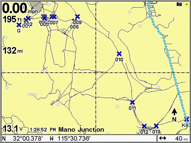
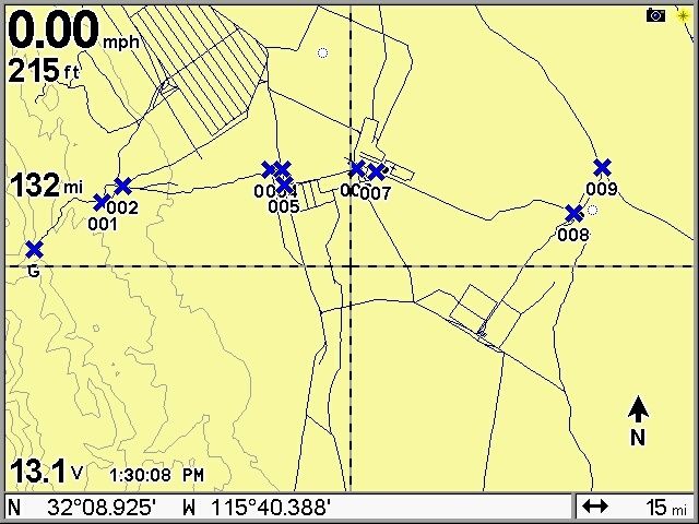
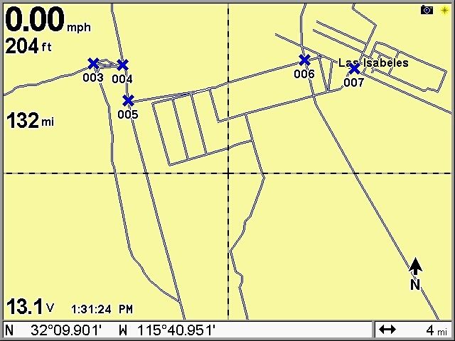
GPS Directions from Guadalupe Canyon to Hwy 5
Below is my file on getting from to. Its a little tricky when you leave the canyon and get to the farming area so I enlarged that area.
Put these coordinates into Google earth and see if you can find the roads that are real. All these roads have been driven and exist. Or after you put
the coordinates into GE you can make a path then save it, then convert it to the format your GPS needs . Free conversion tools are widely available if
you search Google.
Guadalupe 32 09.214N, 115 47.438W
See to GPS Screen shots for waypoint locations. Datum is WGS 84
1) 32 10.124, 115 45.942
2) 32 10.436, 115 45.485
3) 32 10.753, 115 42.185
4) 32 10.742, 115 41.917
5) 32 10.468, 115 41.866
6) 32 10.779, 115 40.248
7) 32 10.712, 115 39.788
8) 32 09.870, 115 35.209
9) 32 10.791, 115 34.729
10) 32 03.891, 115 25.556
11) 31 54.828, 115 22.690
12) 31 50.416, 115 20.104
13) 30 50.444, 115 17.467
Hwy 5 K87 31 51.665, 115 10.923
|
|
|
David K
Honored Nomad
Posts: 65562
Registered: 8-30-2002
Location: San Diego County
Member Is Offline
Mood: Have Baja Fever
|
|
Paul, that looks like you are shooting right out to the dry lake bed from Guadalupe vs. going south on the road to Cohabuzo first?
No doubt that is likely faster and easier!
However, if there is a super-high tide, flooding Colorado River or rain, do you have a track on the Cohabuzo option?
Thanks!
|
|
|
bajatrailrider
Ultra Nomad
Posts: 2553
Registered: 1-24-2015
Location: Mexico
Member Is Offline
Mood: Happy
|
|
| Quote: Originally posted by StuckSucks | I don't think anybody has said it yet, but if you experience any mud on Laguna Salada, REVERSE RUDDER, BAIL OUT!! The mud is legendary for swallowing
vehicles - nasty, salty stuff.
|
This is the best advice anyone could give.
|
|
|
PaulW
Ultra Nomad
Posts: 3113
Registered: 5-21-2013
Member Is Offline
|
|
| Quote: Originally posted by David K | Paul, that looks like you are shooting right out to the dry lake bed from Guadalupe vs. going south on the road to Cohabuzo first?
No doubt that is likely faster and easier!
However, if there is a super-high tide, flooding Colorado River or rain, do you have a track on the Cohabuzo option?
Thanks! |
=====
I have not been to L Salida this fall, but so far the desert has been found very dry. Lots of silt and dust. All the locals are complaining about the
bad dust on the runs. Got a trace of rain two nights ago and since then we have had big time winds and more blowing dust.
I will leave it to others to do the west route.
|
|
|
David K
Honored Nomad
Posts: 65562
Registered: 8-30-2002
Location: San Diego County
Member Is Offline
Mood: Have Baja Fever
|
|
Bump for Geothermal-Shane
|
|
|
Ken Cooke
Elite Nomad
Posts: 8971
Registered: 2-9-2004
Location: Riverside, CA
Member Is Offline
Mood: Pole Line Road postponed due to injury
|
|
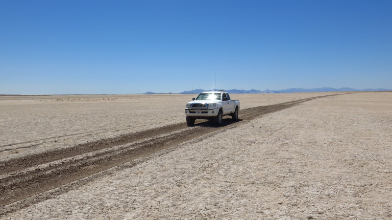
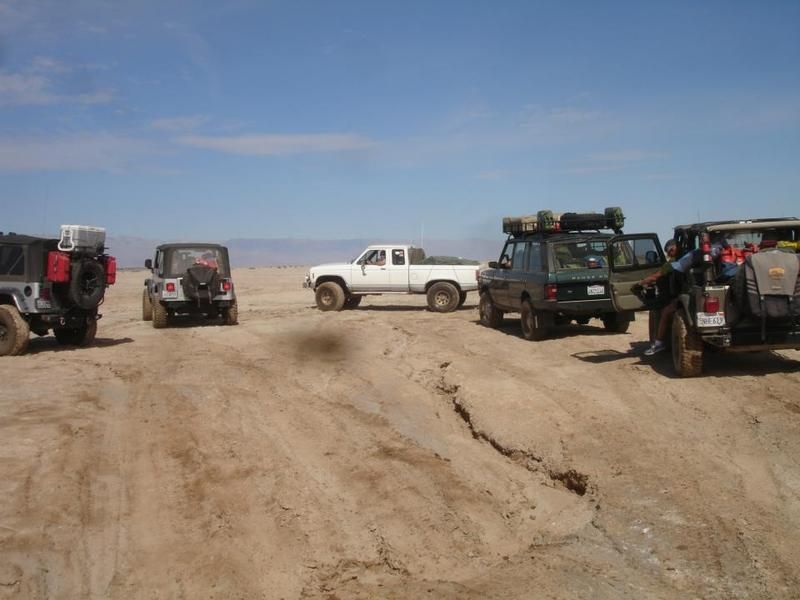
Mud, mud, and more mud - and that's in 2013 - not during El Nino!
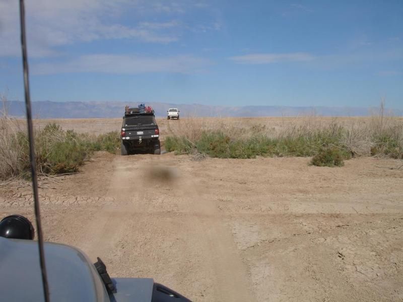
Laguna Salada Creek
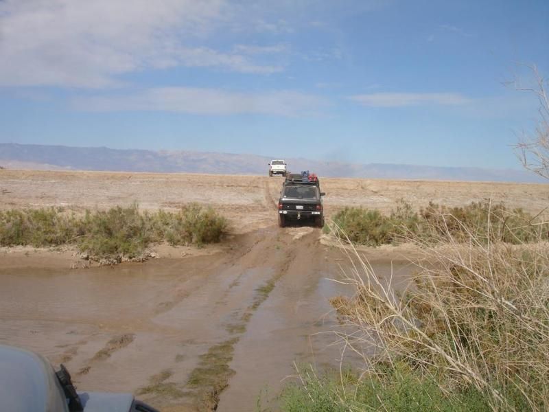
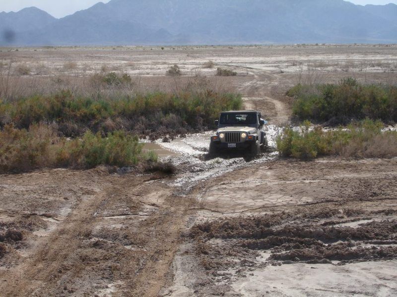
Mick's white pickup led us across the creek
Additional photos showing road turnoffs at:
4WD Baja: Rio Hardy/Laguna Salada/Pole Line Road
[Edited on 2-11-2016 by Ken Cooke]
|
|
|


