| Pages:
1
2 |
David K
Honored Nomad
        
Posts: 65294
Registered: 8-30-2002
Location: San Diego County
Member Is Offline
Mood: Have Baja Fever
|
|
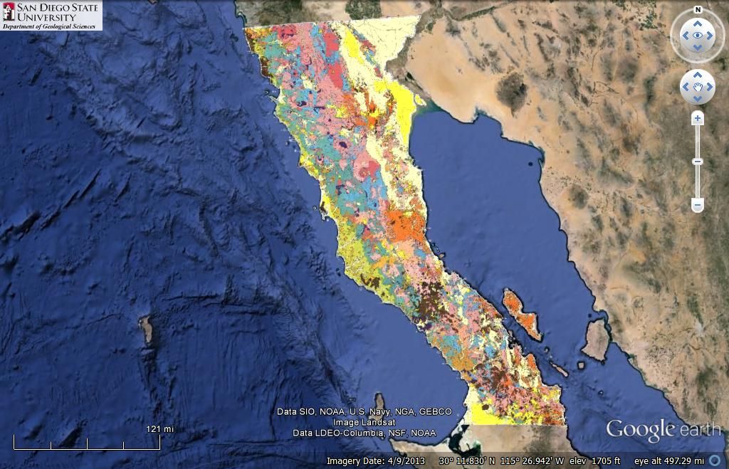
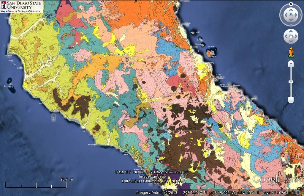
Geology Map of Baja (Norte) on GoogleEarth
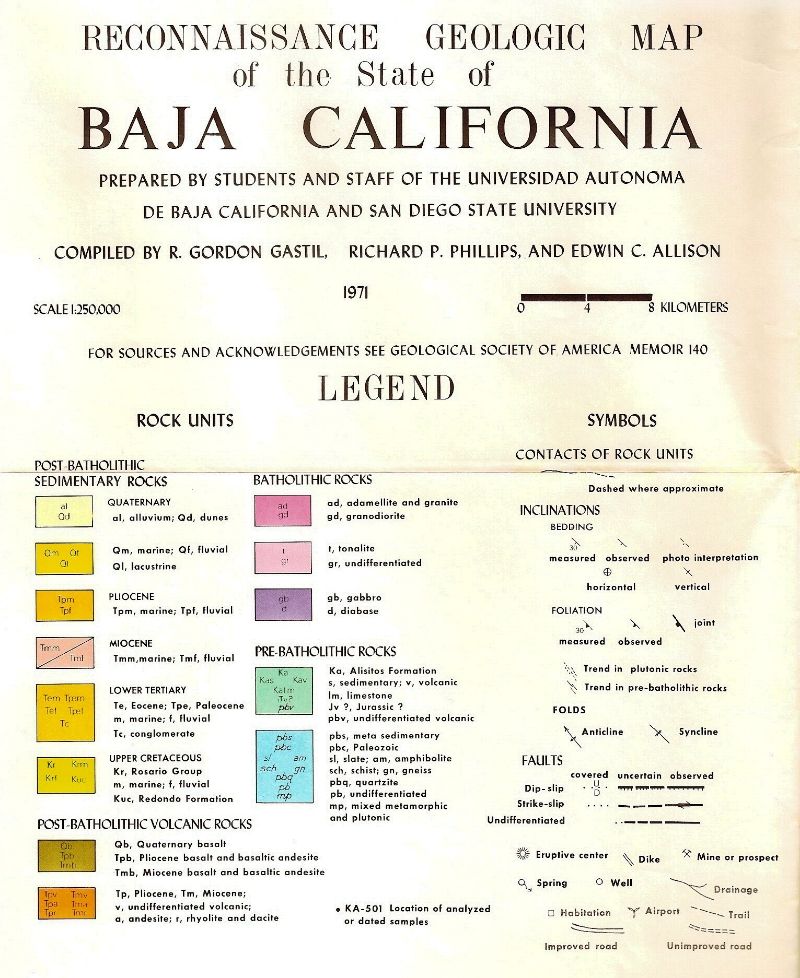
Over on the Pole Line Road thread the question came up how I got the Geology Map from 1971 to overlay on Google Earth...
The map was on a KMZ file from San Diego State University: http://www.geology.sdsu.edu/kmlgeology/kmz/baja140/baja140.h...
Here are some samples...
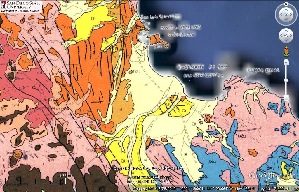
Gonzaga Bay
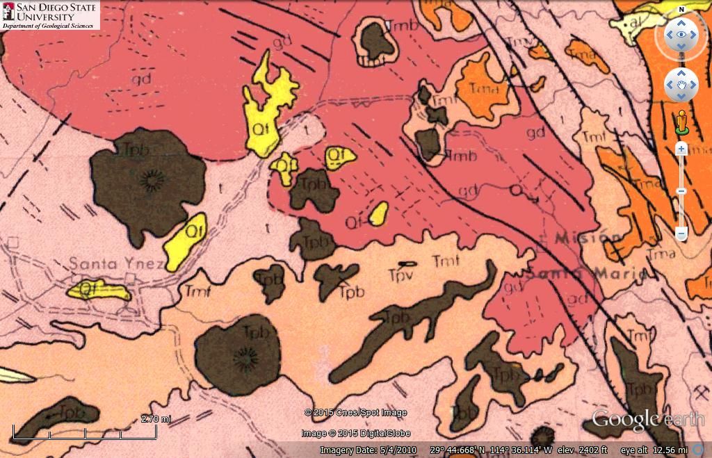
Santa Ynez to Mission Santa Maria
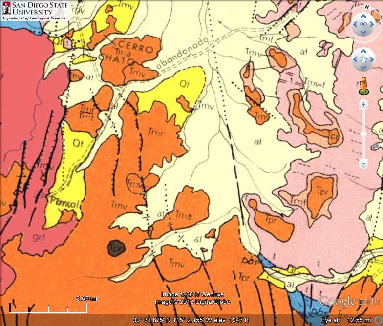
Rancho el Parral (Sulfur Mine to Valle Chico road west half), Matomi Canyon
As always, if you have a request to see an area off this map, want it on Nomad, let me know!
|
|
|
4x4abc
Ultra Nomad
    
Posts: 4439
Registered: 4-24-2009
Location: La Paz, BCS
Member Is Offline
Mood: happy - always
|
|
now I want the southern half
the current one sheds some light on Leon Grande etc
Harald Pietschmann
|
|
|
David K
Honored Nomad
        
Posts: 65294
Registered: 8-30-2002
Location: San Diego County
Member Is Offline
Mood: Have Baja Fever
|
|
GOOD EYE!
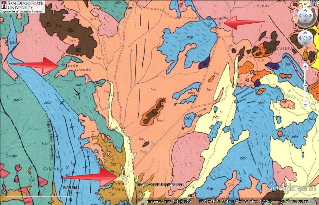
Arrows added pointing Leon Grande, Punta Prieta, Desengaño. The distance from Punta Prieta to Leon Grande is approx. 12 miles (19 kms.)
|
|
|
David K
Honored Nomad
        
Posts: 65294
Registered: 8-30-2002
Location: San Diego County
Member Is Offline
Mood: Have Baja Fever
|
|
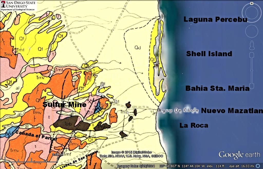
My favorite beach region in Baja...
|
|
|
Cliffy
Senior Nomad
  
Posts: 993
Registered: 12-19-2013
Member Is Offline
|
|
So? Where's the gold?
|
|
|
güéribo
Nomad
 
Posts: 239
Registered: 10-17-2014
Member Is Offline
|
|
Cool map, David. Thanks for the resource.
|
|
|
Alan
Super Nomad
   
Posts: 1628
Registered: 4-6-2005
Location: Yucaipa, CA/La Paz
Member Is Offline
|
|
I've always wondered why geological occurrence created that Boulder Mountain just above GN. It looks like some giant raked up the surrounding plain
and just left the pile. 
In Memory of E-57
|
|
|
David K
Honored Nomad
        
Posts: 65294
Registered: 8-30-2002
Location: San Diego County
Member Is Offline
Mood: Have Baja Fever
|
|
Quote: Originally posted by Alan  | I've always wondered why geological occurrence created that Boulder Mountain just above GN. It looks like some giant raked up the surrounding plain
and just left the pile.  |
El Pedregoso, once the highest mountain in the region made of granite, newer volcanic action surrounded it in a sea of lava. Solid granite breaks down
into boulders with age.

(photo from Google search)
[Edited on 4-27-2015 by David K]
|
|
|
Cliffy
Senior Nomad
  
Posts: 993
Registered: 12-19-2013
Member Is Offline
|
|
Geology is fascinating, too bad I'm not a geologist.
|
|
|
Alan
Super Nomad
   
Posts: 1628
Registered: 4-6-2005
Location: Yucaipa, CA/La Paz
Member Is Offline
|
|
Cool. Makes sense to me. Thanks
In Memory of E-57
|
|
|
DavidT
Nomad
 
Posts: 494
Registered: 4-9-2005
Member Is Offline
|
|
When Rudy and Butch would go out mining Rudy would hide what he found and then leave a pile of rocks along Mexico 1 to guide him back later.
So just look for a pile of Rudy's rocks along the edge of the highway.
David
Not one shred of evidence supports the notion that life is serious.
|
|
|
Cliffy
Senior Nomad
  
Posts: 993
Registered: 12-19-2013
Member Is Offline
|
|
Does that include the rock piles right behind every disabled truck? :-)
|
|
|
Mexitron
Ultra Nomad
    
Posts: 3397
Registered: 9-21-2003
Location: Fort Worth, Texas
Member Is Offline
Mood: Happy!
|
|
Quote: Originally posted by David K  | Quote: Originally posted by Alan  | I've always wondered why geological occurrence created that Boulder Mountain just above GN. It looks like some giant raked up the surrounding plain
and just left the pile.  |
El Pedregoso, once the highest mountain in the region made of granite, newer volcanic action surrounded it in a sea of lava. Solid granite breaks down
into boulders with age.

(photo from Google search)
[Edited on 4-27-2015 by David K] |
Those granitics are part of the Peninsular Range batholith which goes from So Cal to the tip of Baja and were formed at the same time as the Sierra
Nevada Range batholith in the Mezozoic. Batholiths were once massive underground magma chambers which cooled under certain pressure and temperature
to make granite. Over the eons the batholiths have been pushed upward by tectonic forces and exposed. The geometric crystalline-like fault lines
which run throughout the granitics abet the eroding of the rock into the shapes you see today---also exfoliation of layers of granite helps round of
the boulders (they exfoliate layers of rock like an onion since they are no longer underground under enormous pressure). And as David mentioned much
of the Baja batholith has been reburied by volcanic eruptions which occurred from around 10 mya to 2mya as the peninsula separated from the mainland
and the SOC and San Andreas Fault were formed.
|
|
|
Cliffy
Senior Nomad
  
Posts: 993
Registered: 12-19-2013
Member Is Offline
|
|
That's interesting that they exfoliate like an onion. I always thought when granite boulders were "rounded" it had to come from rolling around in a
water environment. But I guess I never thought about rounded large formations of granite couldn't have rolled in water
Learn something new every day.
|
|
|
David K
Honored Nomad
        
Posts: 65294
Registered: 8-30-2002
Location: San Diego County
Member Is Offline
Mood: Have Baja Fever
|
|
Isn't Nomad a great place!?
Thank's Steve for the science!
|
|
|
nico
Newbie
Posts: 5
Registered: 4-24-2015
Member Is Offline
|
|
Thanks David and Mexitron... Geo here too! Field trip... 
|
|
|
nico
Newbie
Posts: 5
Registered: 4-24-2015
Member Is Offline
|
|
Thanks David and Mexitron... Geo here too! Field trip... 
|
|
|
David K
Honored Nomad
        
Posts: 65294
Registered: 8-30-2002
Location: San Diego County
Member Is Offline
Mood: Have Baja Fever
|
|
Welcome to Baja Nomad nico!
|
|
|
nico
Newbie
Posts: 5
Registered: 4-24-2015
Member Is Offline
|
|
Thank you! I'm enjoying the site plus poking around your great vivabaja.com site.
|
|
|
David K
Honored Nomad
        
Posts: 65294
Registered: 8-30-2002
Location: San Diego County
Member Is Offline
Mood: Have Baja Fever
|
|
http://VivaBaja.com is a place for people who have Baja Fever or at least the Baja Bug and need a Fix between their trips to the Motherland!
Glad you like it... I just added a couple of 2010 trips on there and the 2011 Lost Mission Hike is linked to my blog page I started... need to catch
up to 2015!
|
|
|
| Pages:
1
2 |

