| Pages:
1
2
3
4
5
6 |
David K
Honored Nomad

Posts: 64479
Registered: 8-30-2002
Location: San Diego County
Member Is Offline
Mood: Have Baja Fever
|
|
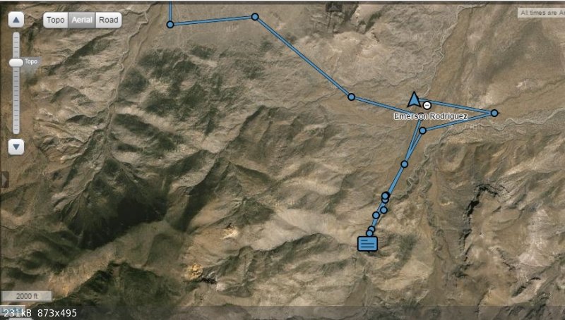
OK, now that Nomad is back online, and I am back home, let's get up to speed with Tom, Roy and Emerson...
I posted a couple of locations on Baja Nomad Facebook earlier, when the forums were off line...
Basically, that they got to the bottom of Cañon Jamau and could not drive any further than the satellite images showed was a road... and could not
even hike the mile up to the ranch/ shack site (which is at the bottom of the road down from the top (Summit #3).
In the following Spot emails I got, they headed back to Summit #1, on the Pole Line Road, and climbed to the top... and out to Hwy. 3.
|
|
|
David K
Honored Nomad
Posts: 64479
Registered: 8-30-2002
Location: San Diego County
Member Is Offline
Mood: Have Baja Fever
|
|
3-4 PM SAT
Emerson sent a message that the summit was VERY rough and then his track shows he began to go to the other summit roads, but about 3 pm turned around
and headed out. Both Emerson's in Reach and TW's SPOT signals show them in Valle de Trinidad at 4 pm today.
There is a signal gap between the mountain road and Hwy. 3.
|
|
|
David K
Honored Nomad
Posts: 64479
Registered: 8-30-2002
Location: San Diego County
Member Is Offline
Mood: Have Baja Fever
|
|
At 3:01 pm, Emerson posted they came to a locked gate, so that was the end of the run to Summit #3. They then moved down to Valle de Trinidad.
|
|
|
David K
Honored Nomad
Posts: 64479
Registered: 8-30-2002
Location: San Diego County
Member Is Offline
Mood: Have Baja Fever
|
|
At 6:25pm Saturday, TW's Spot signal came from Hwy. 3, just east of Ojos Negros Valley. Looks like they are having dinner in Ensenada tonight? Looking
forward to the travel stories... Thanks guys for sharing your locations the past 24 hours with us!
|
|
|
David K
Honored Nomad
Posts: 64479
Registered: 8-30-2002
Location: San Diego County
Member Is Offline
Mood: Have Baja Fever
|
|
Well, just got a Spot and they are near Laguna Hanson tonight.
|
|
|
Mexitron
Ultra Nomad
Posts: 3397
Registered: 9-21-2003
Location: Fort Worth, Texas
Member Is Offline
Mood: Happy!
|
|
Not surprised they couldn't find a way up #3---we took a look around there for a way across and couldn't see anything...must have been quite a gully
washer to scour the canyon out like that. Happens in those mountains though.
|
|
|
David K
Honored Nomad
Posts: 64479
Registered: 8-30-2002
Location: San Diego County
Member Is Offline
Mood: Have Baja Fever
|
|
Quote: Originally posted by Mexitron  | | Not surprised they couldn't find a way up #3---we took a look around there for a way across and couldn't see anything...must have been quite a gully
washer to scour the canyon out like that. Happens in those mountains though. |
I got a more detailed letter from Emerson yesterday about the hike... the road was washed away so it was too narrow to drive on safely, then he
mentioned a dry waterfall... he explored beyond it a few minutes and saw the plain (flat area) beyond, but turned back to rejoin TW. Roy didn't do
that hike and was convinced there was another canyon route, maybe more south. Emerson has a busy week, but will produce a report in time.
After the Spot from Laguna Hanson area, Sat. night, another Spot came in from La Rumorosa on Hwy. 2, Sunday.
Looking forward to hearing Tom and Roy's reports!
[Edited on 6-29-2015 by David K]
|
|
|
TMW
Select Nomad
Posts: 10659
Registered: 9-1-2003
Location: Bakersfield, CA
Member Is Offline
|
|
We drove in to the base of the race summit for Friday night. Weather was good not hot just about right without sleeping bag.
Saturday we drove over to the Y and then to the end of the road toward summit #3. Did not see a road or route west along the ridge of the arroyo.
There appeared to be a road at one time going down into the arroyo. In hindsight it was probably to get water because it didn't go too far. Emerson
and I hiked the arroyo west toward the mtn. rough going getting rougher as we went west. Bushes with thorns, tall grass, rocks and more rocks and
bolder's. Tree like vines. We finally got to a rock wall 30-40 feet high. We climbed and crawled up it. Near the top I stopped for a break and Emerson
went on and hiked further. I waited for him to come back and he said he did not see a cabin but may not have went far enough. Did not see a road from
our location either. Lots of vegetation. We did see a road as we came in on the PLR. Our thoughts were to go back and drive over the race summit and
follow the road to summit #3 and go down it and then look for a cabin.
Emerson looked around at the top of the waterfall and found dried cow manure so we followed what looked to be a cow trail, not a trail you normally
see like a foot wide of soft sand but mostly just dried cow manure. It was a much easier path than in the arroyo. We were around the mountain and out
of sight of the vehicles but following the cow path was the way to go. Back at the vehicles we talked it over and agreed to go up over the race
summit.
The race summit was very rough in several places going up. At one place it was an either/or and Emerson leading went left and did too but I came upon
a large rock that I could not get over. Left right or straight. Roy went right and go up OK so I backed down about 100 yards and followed Roy's path
up and over.
We came to a meadow with a ranch house with a truck and a dog tied up and barking but no one in sight. We continued and after several gates we got to
the Jamau jct and turned toward the hotel/campground/restaurant. A couple of miles past it we came to a metal gate with a large lock in a steel
cylinder. Also steel pipe for a fence so no way around it.
E decided to go in Trinidad for dinner. Emerson left for Mexicali after dinner and Roy and I headed up to Laguna Hanson for the night. Lots of areas
burnt from a fire up there.
Knowing that the cow trail is not hard to follow I think going back would make for good hike looking for the cabin. Maybe when it is cooler.
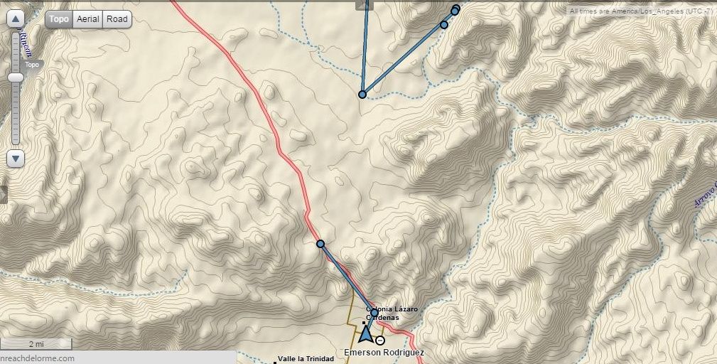
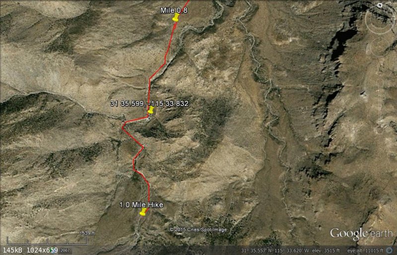
The waterfall is at 31-35.599x115-33.832 at 3296 feet AMSL.
|
|
|
David K
Honored Nomad
Posts: 64479
Registered: 8-30-2002
Location: San Diego County
Member Is Offline
Mood: Have Baja Fever
|
|
Thank you for the report!
I was on the phone with Roy this afternoon, as well.
Here's the GPS for your waterfall TW. The Mile 0.8 is the end of the road from the Y on the Pole Line Road. The 1.0 Mile Hike is about where the cabin
was in 1961, per Howard Gulick.
|
|
|
TMW
Select Nomad
Posts: 10659
Registered: 9-1-2003
Location: Bakersfield, CA
Member Is Offline
|
|
I purchased a Garmin NUVI-52LM GPS on ebay a few weeks ago. It has a 5 inch screen and comes with the USA maps. I loaded the E32 Cartografia Mexico
map. It worked great. It shows hwys in yellow. Main dirt roads in purple and secondary roads in white. Arroyos in blue. Following the road to the base
of the race summit in purple then the road to the PLR Y was also in purple and after the Y in white.
Coming down the La Rumarosa grade it showed me going cross country a few times so I guess the road has changed over the years. It mounts to the
windshield on a suction cup but I think I'll do a hard mount to the dash. The suction mount worked OK on the trip, no problems.
|
|
|
David K
Honored Nomad
Posts: 64479
Registered: 8-30-2002
Location: San Diego County
Member Is Offline
Mood: Have Baja Fever
|
|
Roy told me you had an impressive GPS map now.
In hindsight, would you go up Summit #2 knowing that #1 was so rough? However, coming down west from #2, do you think a gate would have trapped you
guys?
Also, do you think there is another, more southern approach to get to Summit #3 (from Hwy. 3/ the west)?
|
|
|
TMW
Select Nomad
Posts: 10659
Registered: 9-1-2003
Location: Bakersfield, CA
Member Is Offline
|
|
Yes the locked gate was before the turn to summit #2 so coming up #2 we would have had to turn around and go back down.
I've been past the locked gate (before it was put in) and we followed the road around to a plane crash site. I have also followed the routes on GE and
I don't see any other way to summit #3.
Summit 1 was rougher than I had seen it before but the only hangup was the one place with the big rock that I couldn't get over. I think I was getting
one wheel up in the front and losing traction. We joked that if I had Atrac I could have made it and I probably would have. But the trail Roy took was
much easier. Emerson has lockers front and rear.
|
|
|
PaulW
Ultra Nomad
Posts: 3005
Registered: 5-21-2013
Member Is Offline
|
|
Access to #2
At the north end of Summit 2 there is evidence from my last trip that the bulldozer had made a new path where we made the turn to bypass the lock
gate. Two of us walked up that steep slope and sure enough there was a road heading south. I am not sure any of us could climb that steep path up the
bank. Maybe front & rear lockers would work?
Then there is another road from they that crossed the gully just south of that place. Look on GE and see it.
If the guys found summit 1 road difficult then they were not on the new road. I published the old and new road tracks previously. You all need to
get a proper GPS that can share tracks. For a current Garmin that would be an Oregon or Montana. Many older versions of hiker GPS will also work.
Nuvi's do not have track sharing capability.
|
|
|
David K
Honored Nomad
Posts: 64479
Registered: 8-30-2002
Location: San Diego County
Member Is Offline
Mood: Have Baja Fever
|
|
| Quote: Originally posted by PaulW | Access to #2
At the north end of Summit 2 there is evidence from my last trip that the bulldozer had made a new path where we made the turn to bypass the lock
gate. Two of us walked up that steep slope and sure enough there was a road heading south. I am not sure any of us could climb that steep path up the
bank. Maybe front & rear lockers would work?
Then there is another road from they that crossed the gully just south of that place. Look on GE and see it.
If the guys found summit 1 road difficult then they were not on the new road. I published the old and new road tracks previously. You all need to
get a proper GPS that can share tracks. For a current Garmin that would be an Oregon or Montana. Many older versions of hiker GPS will also work.
Nuvi's do not have track sharing capability. |
Paul, are you saying the entire summit grade (#1) has a parallel newer road? I know you shared that the bottom was different and berms blocked the old
part near the bottom (opposite the locked gate)...?
|
|
|
PaulW
Ultra Nomad
Posts: 3005
Registered: 5-21-2013
Member Is Offline
|
|
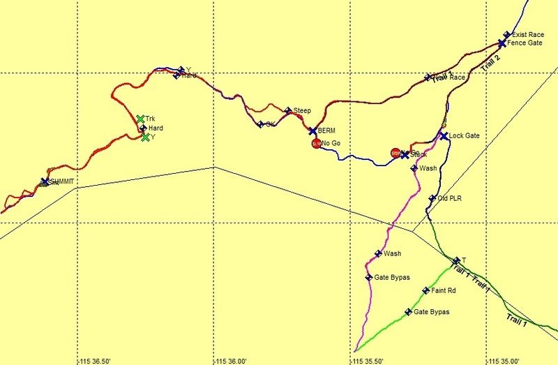
Not only did I publish this image, but I gave out a GPS track for all the tracks shown.
This image is a screen shot of my GPS after I drove the roads.
The road called New Race has never been raced on and is made properly so as to have very little erosion damage. It goes up a different ridge that the
old one. Pay attention to the location of fence gate, lock gate, stuck, berm, etc.
I might add that there are many more old roads on the grade up to Summit 1 and some are really hard. This is the reason I only gave out the easy
tracks.
|
|
|
David K
Honored Nomad
Posts: 64479
Registered: 8-30-2002
Location: San Diego County
Member Is Offline
Mood: Have Baja Fever
|
|
| Quote: Originally posted by PaulW | Not only did I publish this image, but I gave out a GPS track for all the tracks shown.
This image is a screen shot of my GPS after I drove the roads.
The road called New Race has never been raced on and is made properly so as to have very little erosion damage. It goes up a different ridge that the
old one. Pay attention to the location of fence gate, lock gate, stuck, berm, etc.
I might add that there are many more old roads on the grade up to Summit 1 and some are really hard. This is the reason I only gave out the easy
tracks.
|
Thanks, that is what I remember you posting from the week before our Pole Line Road trip... that a new bottom section for the summit was in place.
Looks like it replaces about the bottom 1/4 of the grade? Then just above the new road I see you show a 'steep' vs. 'ok' new detour...
TW, where on this map was the locker/ A-TRAC rock?
|
|
|
TMW
Select Nomad
Posts: 10659
Registered: 9-1-2003
Location: Bakersfield, CA
Member Is Offline
|
|
Before the locked gate is a fence gate that we went thru to the bypass to get around to the PLR Y. Coming back when you go back thru the fence gate
you make a hard left U turn to get on the race summit road as shown above.
The new summit course is more rough than I remember from years past in several areas. The area I had a problem and had to back down appears to be at
the Y hard line that shows a red and blue line above. It was at a either/or area. In years past the left side going up was normally not used because
of the washouts. Looking at GE it appears to be at 31-37.860x115-36.230. We didn't have any trouble after that.
|
|
|
TMW
Select Nomad
Posts: 10659
Registered: 9-1-2003
Location: Bakersfield, CA
Member Is Offline
|
|
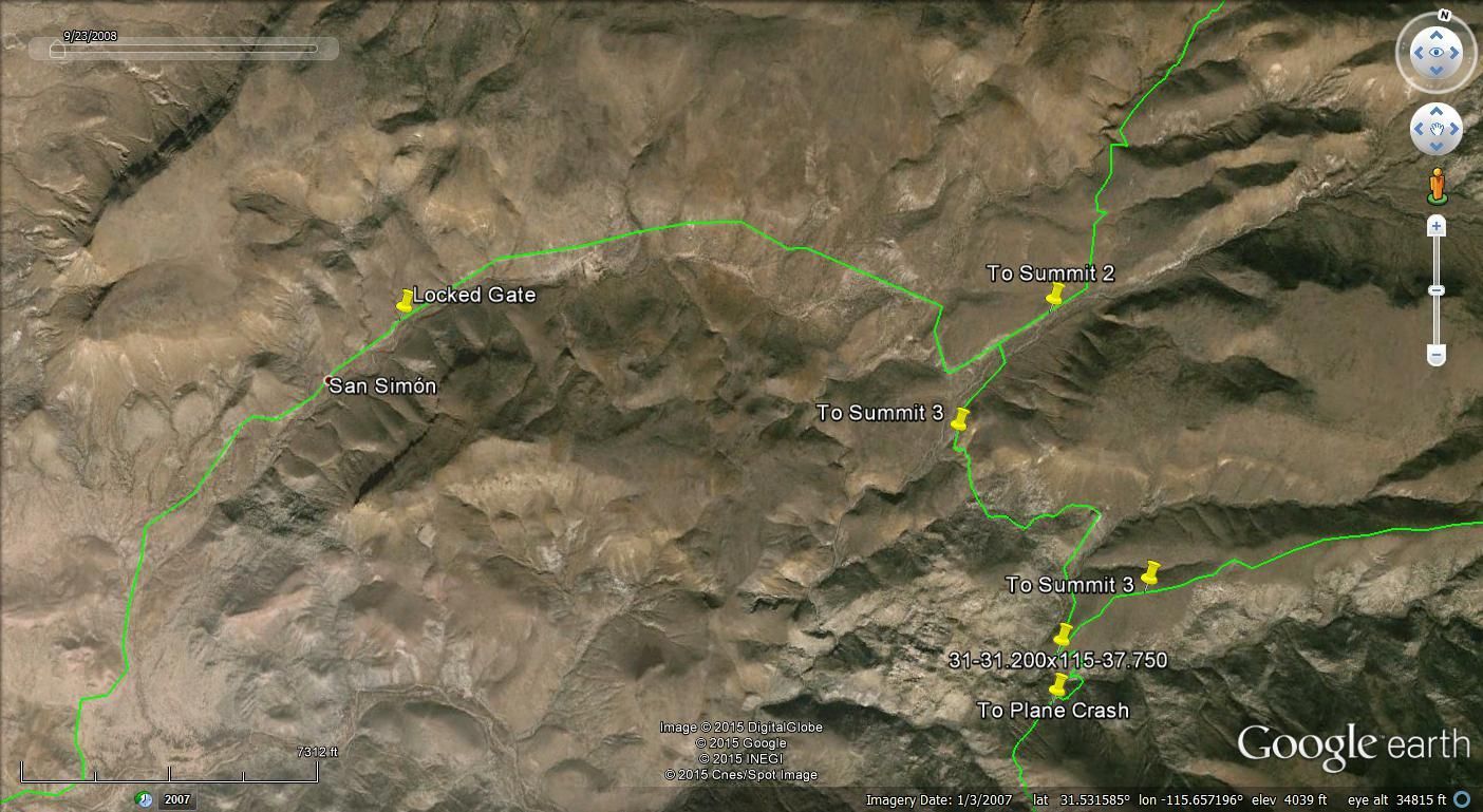
This is where the locked gate is in reference to the summit 2 and 3 roads
|
|
|
Ken Cooke
Elite Nomad
Posts: 8921
Registered: 2-9-2004
Location: Riverside, CA
Member Is Offline
Mood: Black Trans Lives Matter
|
|
| Quote: Originally posted by TMW |
Summit 1 was rougher than I had seen it before but the only hangup was the one place with the big rock that I couldn't get over. I think I was getting
one wheel up in the front and losing traction. We joked that if I had Atrac I could have made it and I probably would have. But the trail Roy took was
much easier. Emerson has lockers front and rear. |
Was the rock you describe like a steep stair step, that climbed a steep angle several hundred feet? If so, we took the Jeeps up that section, risking
our lives, but making it to the top.
|
|
|
PaulW
Ultra Nomad
Posts: 3005
Registered: 5-21-2013
Member Is Offline
|
|
dk wrote,
Thanks, that is what I remember you posting from the week before our Pole Line Road trip... that a new bottom section for the summit was in place.
Looks like it replaces about the bottom 1/4 of the grade? Then just above the new road I see you show a 'steep' vs. 'ok' new detour...
== ====
Not a detour just an either or. Been using them both for many years.
Steep is not so loose pitch with good traction. Used for years by the racers. 3 of my party went up it. The rest of us took the OK which is the shelf
road version. It has a pretty good drop off, but has more than enough clearance for a trophy truck.
Above that we just keep right to avoid the pitfalls and washouts of the hard sections. The racers never go the hard way. So the result is the that is
the loop road that everybody uses.
Connect the two "Hard" places and you have the route that we all avoid
[Edited on 6-30-2015 by PaulW]
|
|
|
| Pages:
1
2
3
4
5
6 |


