| Pages:
1
2 |
Fatboy
Senior Nomad

Posts: 711
Registered: 6-28-2005
Member Is Offline
|
|
Walter Henderson's Lost Rock Pile - A more likely search area?
Reading all of the Post's from this site, Desert Magazine articles and now the original Walter Henderson letters is interesting and makes you want to
put boots on the ground.
One statement you hear quite often is that research is the majority of the work and groundwork is the final, hopefully, conclusion.
One problem is the long distance of time, 80 years have passed since the original discovery, 30 years have lasped between the discovery and his
letters documenting the event and now another 45 years have gone by.
Sadly, I will be required to make some assumptions and will try to point them out as such when I do.
There is also a lack of original source material, which appears to consist of two 'letters'. If there are more documents they could certainly shine
some more light on the trek that Walter took that day in the 1930's.
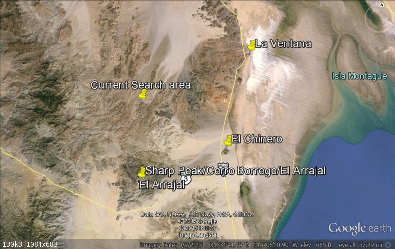
The area that DK and other are currently searching seems to be too far to the Northwest to me.
TMW and some others seem to be more on track.
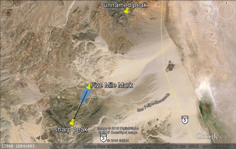
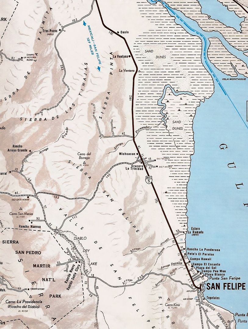
Here is an over all view with the current search area, Sharp Peak and El Chinero marked.
[Edited on 7-16-2015 by Fatboy]
|
|
|
Fatboy
Senior Nomad
Posts: 711
Registered: 6-28-2005
Member Is Offline
|
|
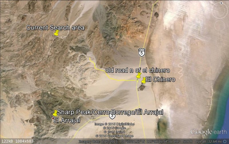
Walter's letters do give 3 sets of instructions, 1 that covers were they started from and two that cover the area of the search.
As far as the starting point I read it as....
Travel south of La Ventana for 20 miles, which is also about 5 miles south of the road heading west a little north of El Chinero.
From there head almost directly west parking in the area of 31 25 N.
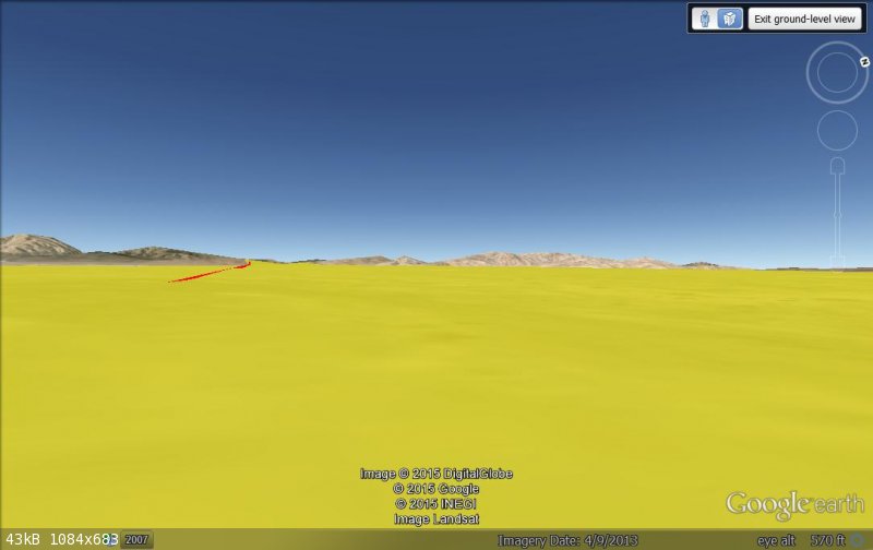
This shot shows a road north of El Chinero were some tracks are visible going west then north as shown on the map in the book The Lower California
Guidebook. I drew in the road in yellow in just the general area, it does not actually follow the tracks you can still see in Google Earth. This area
is about 15 miles south of La Ventana.
|
|
|
Fatboy
Senior Nomad
Posts: 711
Registered: 6-28-2005
Member Is Offline
|
|
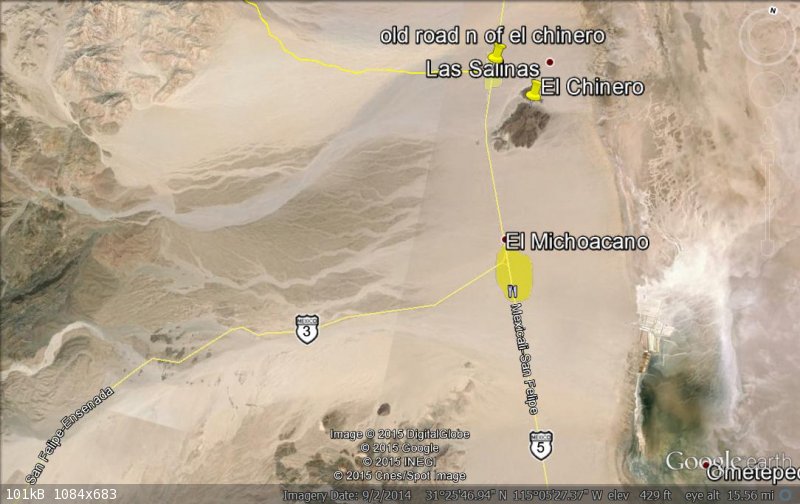
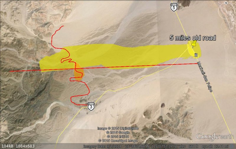
Now from the road north of El Chinero Walter states that they drove'...about five miles below...' this road which now places them about 20
miles from La Ventana and is shown here highlighted in yellow.
|
|
|
Fatboy
Senior Nomad
Posts: 711
Registered: 6-28-2005
Member Is Offline
|
|
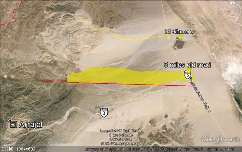
From the Mexicali - San Felipe road the letters says that '...going mmore(sic) or less directly west to the base of the hills towards what
appeared a plausable route to follow over the saddle, - just us, not the model A.'
Two clues there, directly west and towards a saddle.
Here is a screen shot showing west from my estimated turn off which is highlighted in yellow.
He also states that they drove the Model A and parked at the '...base of the Sierra pintos at about 31 25 N...'
The red line is on 31 25 N.
They would have parked near where the red line and yellow are converge close to the base of the hills.
|
|
|
Fatboy
Senior Nomad
Posts: 711
Registered: 6-28-2005
Member Is Offline
|
|
He also mentions the saddle.
In this shot you are looking west from the old Mexicali - San Felipe road towards the hills with Sharp Peak/Cerro Borrego/El Arrajal on the left side
and a prominent saddle directly in front of them.
|
|
|
Fatboy
Senior Nomad
Posts: 711
Registered: 6-28-2005
Member Is Offline
|
|
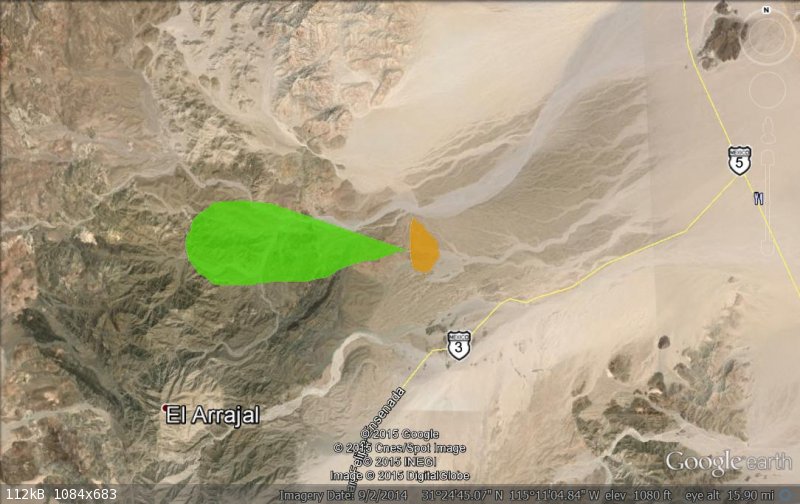
So far most everyone agrees on this and roughly where Walter parked which I show here in orange.
|
|
|
Fatboy
Senior Nomad
Posts: 711
Registered: 6-28-2005
Member Is Offline
|
|
Now here is where we start to disagree. DK believes that Walter hiked the next morning in a Northwest direction and covered about 10 miles as the
crows fly to end up that night in Arroyo Grande where they spent the night.
My reading of the letters do not disclose a direction. If they were going to hike NW why not park further north?
Then there is the distance covered that day. It is about 10 to 11 AIR MILES to Arroyo Grande from the area that they parked in.
With out trails, route finding on the way and the fact they must have been carrying packs of some sort (my assumption) with sleeping gear, food and
water it would be nigh impossible to cover that distance in a day. My guess for the ground distance would by at least 15 miles and probably closer to
20 miles.
A reasonable estimate would be a pace of 1/2 to 1 MILE PER HOUR.
Furthermore he says 'In the morning we hiked up and over a pretty rugged hillside, too rugged for any vehicles at that time.'. Not over many
hills or up any washes just a pretty straightforward A PRETTY RUGGED HILLSIDE.
Here is were I believed they hiked....the area in green covers about 5 miles (air miles! much further on the ground) east to west and about two miles
at the widest point north to south.
The interesting thing is it is basically 1 PRETTY RUGGED HILLSIDE hike.
[Edited on 7-16-2015 by Fatboy]
|
|
|
Fatboy
Senior Nomad
Posts: 711
Registered: 6-28-2005
Member Is Offline
|
|
I will come back to the hike later but lets look at Walter's other two sets of directions to the area.
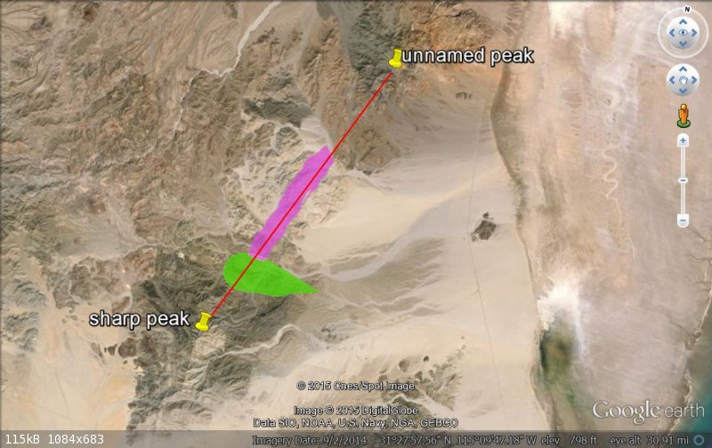
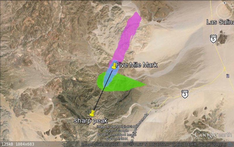
One talks about drawing a line from Sharps Peak/Cerro Borrego/El Arrajal North 25 East for about 12 miles to another unnamed peak.
Walter states 'If we draw a line from Sharp Peak to the smaller northerly peak it will roughy follow the divide of the range. separating the
watershed that flows to the Sea from that which flows to Arroyo Grande.
Which is what the red line is with the exception that the line is 16 miles long and not 12 miles. This is another assumption on my part based on the
fact he was looking at a large scale paper map and judging distance and the fact that he said 'ABOUT 12 MILES.
Another point to back up the 16 mile line is that he gives the coordinates for both peaks and the longer line fits perfectly.
He also says Somewhere near the center of that line. plunging down the westerly slope , is a rather deep rock-strewn arroyo...'
Which I have marked in purple.
I also left the green shading where I believe they hiked.
|
|
|
Fatboy
Senior Nomad
Posts: 711
Registered: 6-28-2005
Member Is Offline
|
|
Now he gives one more clue to the area with the Rock-Pile. Walter states in his letters about flying over Cerro Borrego and these are the instructions
he gives. Fly '... on a norterly(sic) course toward the un-named peak bearing N 25 degrees E.
On that heading he said go '...about 5 miles northerly of Cerro Borrego, ...'
At the 5 mile mark you should '...look down and slightly to the east, but look closer at the land to westward...' and if you are flying over '...a
rugged ravine plunging down from the the eastward...' you are in the right area
This shows a black line going N 25 E from Sharp Peak/Cerro Borrego/El Arrajal for 5 miles with the Rock-Pile area in blue.
[Edited on 7-16-2015 by Fatboy]
|
|
|
Fatboy
Senior Nomad
Posts: 711
Registered: 6-28-2005
Member Is Offline
|
|
All three areas look like this on Google Earth....
Blue is the flight area, purple is the middle section between the two peaks and green is my guess on the hike area.
|
|
|
Fatboy
Senior Nomad
Posts: 711
Registered: 6-28-2005
Member Is Offline
|
|
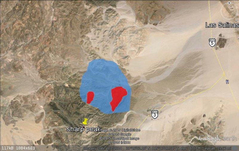
So my suggested search area is shown here in blue with the most likely areas in red with the larger red area my best guess at this point.
|
|
|
Fatboy
Senior Nomad
Posts: 711
Registered: 6-28-2005
Member Is Offline
|
|
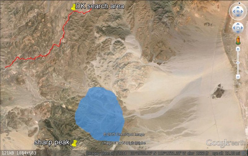
So far the only thing I have avoided is Arroyo Grande.
Which I will cover later if needed but here is my suggested search area in blue, Arroyo Grande is the redline and the area near DK's search area.
There just seems to be a big variance there if we are both using the same sources and one of the only reason that could be is probably because Walter
Henderson mentions hiking down and spending the night in Arroyo Grande.
He mentions it several times in his letter....
Once on the first day and after leaving the car they...
'...walked, slept in Arroyo Grande and walked back.'
and after finding the Rock-Pile around noon he says that they then traveled....
'...thence on down into the wide level bed of the Arrowo (sic) Grande between some huge verticle walled blocks
Could he have been mistaken? Possibly and there are a few clues to support the view that he was mistaken as to the name of the wash.
|
|
|
PaulW
Ultra Nomad
Posts: 3005
Registered: 5-21-2013
Member Is Offline
|
|
Fatboy.
One of the things I intend to do is the walk or drive from where they parked the Model A. That would be the arroyo/wash that drifts to the W-NW and
sort of parallels Arrajal. Of course that would be in your blue area.
Until that task is complete the understanding that Henderson could even get to AG in one day.
The other unknown what the Diaz's party was thinking about heading down AG or even heading west from the Model A park place? Logic tells me a large
group with horses would not go in such places that include climbing like hikers do.
PaulW
|
|
|
David K
Honored Nomad
Posts: 64478
Registered: 8-30-2002
Location: San Diego County
Member Is Offline
Mood: Have Baja Fever
|
|
Wonderful research and mapping Fatboy!
My search area is actually south and east of your pushpin. Arroyo Grande is just where the search arroyos drain into (and where Henderson camped after
finding the rock pile.
The direction of the hike after leaving the Model A is indeed provided... their destination goal, which was northwest of where they parked... As for
why not park further north... it was a Model A in 1930 something. No roads... and so they drove as far as they could.

The Sierra Palmitas and Tinajas is where they wanted to look for blue palms. On the following older AAA map, both those ranges , as well as Arroyo
Grande and Cerro Borrego are shown...
He is also very clear that they found it in a ravine dropping down, westward into Arroyo Grande. Borrego Peak (Arrajal today) was not visible from the
ravine.
Hiking 10-20 miles should not have been an issue for them. The divide of the Pinta range above the three washes I focused on is 10 miles from the
Model A. The ravines down to Arroyo Grande are between 1.5 and 3.5 miles long, to their camp in Arroyo Grande. The rock pile was 1/4 to 1/3 down the
ravine.
Henderson must have realized they started too far south... which again indicates they would have hiked as much north as west.... Blue arrows uphill,
Red arrows are downhill routes to Arroyo Grande:
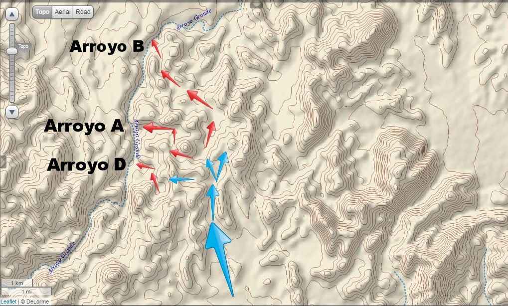
The blue arrows go up the natural saddle in the range... there could be another, going west from the Model A. An excellent alternate search area!
So, keep up the detective work... nobody is wrong here.... just different eyes and brains working on this, which is wonderful to finally have so much
interest in.
The best we can do is have Jim McCoy's helicopter for a day... zip up and down each west flowing arroyo, pronto! Only if Google Earth improves its
sharpness could it be easier... or there could be another option???
Keep up the good work!
[Edited on 7-16-2015 by David K]
|
|
|
BajaGeoff
Super Nomad
Posts: 1727
Registered: 1-11-2006
Location: San Diego and Campo Lopez
Member Is Offline
Mood: Heading To Baja!!!
|
|
Nice work Fatboy! I was also thinking that the rockpile could be further south. We know Henderson put his thoughts down on paper many years after he
found the rockpile, and I also thought they might have come upon a wash they mistakenly thought was Arroyo Grande.
Time will tell...let's get a group out there when it cools off a bit!
|
|
|
David K
Honored Nomad
Posts: 64478
Registered: 8-30-2002
Location: San Diego County
Member Is Offline
Mood: Have Baja Fever
|
|
You know what may have been more helpful from Walter is more on the hike back to the Model A?
He only mentions arriving in the wide, level Arroyo Grande, describes the rock formations there, and said that was before reaching the base of Cerro
Borrego... That would be on the return hike.
Were they just lucky to find another way back over the Sierra Pinta to the Model A, along the base of Cerro Borrego? They chose to try another way
instead of going back past the rock pile, as that ravine was very rugged...?
|
|
|
Fatboy
Senior Nomad
Posts: 711
Registered: 6-28-2005
Member Is Offline
|
|
Yes it is interesting that we all take different views of the same information.  No wonder so many 'lost treasures' stay just that!
But in the spirit of keep this lively lets look at your points in your reply.....
| Quote: |
The direction of the hike after leaving the Model A is indeed provided... their destination goal, which was northwest of where they parked... As for
why not park further north... it was a Model A in 1930 something. No roads... and so they drove as far as they could.
|
Again, no direction is given, just a name, Arroyo Grande and assume for just the sake of an open mind that he was wrong on the name
of the arroyo.
Here are some points...
He did not have our more modern maps, he based his route on a more modern map(Lower Ca Guidebook) which can easily be misread as to which arroyo is
Arroyo Grande as TMW pointed out.
Also he said
| Quote: |
'...thence on down into the wide level bed of the Arrowo (sic) Grande between some huge verticle walled blocks of sedimentary (penciled in next to
that is ', or gravel') formation before reaching the base of Cerro Borrego.'
|
From the Rock-Pile to the Arroyo Grande to the BASE OF CERRO BORREGO. No where does the actual Arroyo Grande be in an area considered as the BASE OF
CERRO BORREGO.
| Quote: |
He is also very clear that they found it in a ravine dropping down, westward into Arroyo Grande. Borrego Peak (Arrajal today) was not visible from the
ravine.
|
Well he is clear(very? perhaps not) about a arroyo that he calls Arroyo Grande, what if he called the wrong arroyo Arroyo Grande? The map he used is
certainly unclear as to the REAL ARROYO GRANDE.
| Quote: |
Hiking 10-20 miles should not have been an issue for them. ... The rock pile was 1/4 to 1/3 down the ravine.
|
First of all 10 - 20 miles? It is 10 air miles, so probably 20 ground miles. It is not 10 miles, it is way more. Now a reasonable estimate is .5 to
1.5 MPH for cross country travel and that means they could only go 5 to 15 miles in a day at the very most.
Follow that up with his quote....
| Quote: |
In the morning we hiked up and over a pretty rugged hillside, too rugged for any vehicles at that time.'
|
Now does that sound like a 10 mile cross country hike? Look at the terrain going your route, does it fit?
Now do not forget they were carrying packs of some sort. One of your day hikes on the search in Arroyo Grande you even mention that it took you an
hour to go 1/2 mile without an overnight pack.
As to the comment 1/4 to 1/3 of the way down was the Rock-Pile...where did you find that information?
Why do you 'ignore' his comments of flying north of Cerro Borrego where he clearly states the ravine is within 5 miles of the peak?
| Quote: |
'... on a norterly(sic) course toward the un-named peak bearing N 25 degrees E...about 5 miles northerly of Cerro Borrego, ...look down and slightly
to the east, but look closer at the land to westward...a rugged ravine plunging down from the eastward...'
|
While your current search area is 12 air miles form the peak.
Hopefully all this discussion will help someone find it! And, even better if you and others including me can be there!
|
|
|
David K
Honored Nomad
Posts: 64478
Registered: 8-30-2002
Location: San Diego County
Member Is Offline
Mood: Have Baja Fever
|
|
His letter says 1/4 to 1/3 down the ravine.
I used Google Earth path (walking) measuring to figure the 10 miles from the model A... Naturally, walking in sand will be harder... but if they began
near sunrise, and walked at least 2 mph, that would give them 12 miles by noon...?
He says (to Choral Pepper) that if she should be flying over that area where about to begin looking .... 5 miles nothward from Borrego. Planes or
copters fly fast so to begin looking before the target area is good advice.
When he wrote the letter, he had Howard Gulick's Lower California Guidebook map... the 5 miles from Borrego was where to begin looking... but he also
said westward of the line between the two peaks... Now the water flow divide is not below that line, if drawn straigtht... more like the letter C,
closer to Arroyo Grande.
When he did the expedition he seemed well aware of the names Arroyo Grande and Arroyo Tule (Jaquegel) or even went into Tule. He is so brief on the
details of his day 2, we don't know.
He seems very certain about being in a west flowing arroyo, dropping down into Arroyo Grande... which is north flowing.
That (to me) eliminates the east flowing arroyo at the base of Cerro Borrego (Arrajal) as an alternate Arroyo Grande (with the Gulick map ranch name
printed along it).
But who knows... until it is found???
Keep up the good investigating!!
[Edited on 7-16-2015 by David K]
|
|
|
Fatboy
Senior Nomad
Posts: 711
Registered: 6-28-2005
Member Is Offline
|
|
| Quote: |
The other unknown what the Diaz's party was thinking about heading down AG or even heading west from the Model A park place? Logic tells me a large
group with horses would not go in such places that include climbing like hikers do.
|
PaulW - I agree with you that it seems an 'odd' area for the Spanish to be at that time so I am looking for a 'Rock-Pile' and not a 'Spanish Captain's
grave'.
I believe if the Rock-Pile is where Walter Henderson said, then it is probably not Diaz's grave.
BajaGeoff -
| Quote: |
We know Henderson put his thoughts down on paper many years after he found the rockpile, and I also thought they might have come upon a wash they
mistakenly thought was Arroyo Grande.
|
I agree that Walter was calling the wrong arroyo the Arroyo Grande.
If for no other reason is that everything, and I truly mean EVERYTHING in his letters fits EXCEPT the name of the arroyo.
While to make the correct Arroyo Grande fit you need to place qualifiers and/or make allowances for EVERY statement except the arroyo's name.
DavidK -
| Quote: |
You know what may have been more helpful from Walter is more on the hike back to the Model A?
|
Yes, I would love to have the opportunity to pose questions to Walter...
What time did you leave that first morning?
What direction did you head?
What did you carry?
How far do you believe you traveled?
How did you return?
WHERE IS IT?!!?!?!
But....
Also
| Quote: |
His letter says 1/4 to 1/3 down the ravine.
|
Had to reread the letters to see that! Thanks! Exactly what a discussion should
accomplish!
| Quote: |
I used Google Earth path (walking) measuring to figure the 10 miles from the model A... Naturally, walking in sand will be harder... but if they began
near sunrise, and walked at least 2 mph, that would give them 12 miles by noon...?
|
We don't know what time they left that morning and so I believe a conservative guess might be more realistic, say 8am?
The 2 mph figure is completely out of line. I would be inclined to say impossible in their walk...the terrain, route finding, without an exact
destination in mind just a general area...
In march of this year we spent two weeks camping in Big Bend National Park with several day hikes of 1 to 5 miles in length and one longer 9 mile hike
and we averaged about 1mph, maybe 1.25 mph.
Then we spent almost all of April in the Escalante, Utah area at the end of Hole-in-the-Rock road do some hiking. We hiked 80 to 90 miles in the time
we were there with most of the miles being day hikes and we never achieved 2 mph for any distance.
2mph would be a reasonable speed on a groomed trail or road with little or few breaks.
You even stated on one of your short hikes that you only did a HALF MILE PER HOUR.
| Quote: |
When he wrote the letter, he had Howard Gulick's Lower California Guidebook map... the 5 miles from Borrego was where to begin looking... but he also
said westward of the line between the two peaks... Now the water flow divide is not below that line, if drawn straigtht... more like the letter C,
closer to Arroyo Grande.
|
Actually he said...
| Quote: |
'When about five miles northerly of Cerro Borrego, look down and slightly to the east, but look closer at the land to westward; and if you should now
be flying over a rugged ravine plunging down from the eastward, circle, and look again...'
|
He did not say ...STARTING LOOKING FOR....
Also he said fly on a bearing of 25 E, while the true Arroyo Grande in your search area is on a bearing 348 W, quite a distance plus your are 12+ air
miles away....it does not fit.
| Quote: |
When he did the expedition he seemed well aware of the names Arroyo Grande and Arroyo Tule (Jaquegel) or even went into Tule. He is so brief on the
details of his day 2, we don't know.
|
We do not know that, he might have known the names after the fact, probably a reasonable assumption though, but that does not matter if he made a
mistake as to which arroyo he was in.
And yes, more details would be awesome.....
|
|
|
David K
Honored Nomad
Posts: 64478
Registered: 8-30-2002
Location: San Diego County
Member Is Offline
Mood: Have Baja Fever
|
|
Great... thanks for your interest! I have been posting this Diaz Grave story by Choral Pepper here for many years. BajaLou really wanted to search for
it, so in a way, this is for him, too!
I am so happy that TW and XR Phil did the initial ground expedition up Arroyo Grande cataloging the washes they saw coming in from the Sierra Pinta.
Then a big thanks to PaulW for his hike into Arroyo B from Arroyo C.
Now Fatboy is really getting all the details anylized, great!
Arroyo Grande is such a major wash and passage from San Matias to the Colorado, documented by Arthur North and Edward Nelson in 1905-1922 expeditions
and publications, that I do not believe Henderson was confused about its locvation. Borrego Peak is a major point of reference. We noted it while on
the Pole Line Road, from a great distance away. I think Henderson did as well... BUT, until we find the rock pile, it is anyone's guess, yes?
Cerro Borrego/ El Arrajal
What is clear from the three arroyos we explored so far (A, B, D), that no troup of Spanish soldiers and Indian guides rode or walked through here
with a injured captain in tow.
|
|
|
| Pages:
1
2 |


