| Pages:
1
2 |
jbbarker1947
Newbie
Posts: 3
Registered: 8-26-2015
Location: La Paz
Member Is Offline
|
|
New Airport road south of Todos Santos
Is the new airport road open?
I really did a search prior to posting.
|
|
|
David K
Honored Nomad

Posts: 64532
Registered: 8-30-2002
Location: San Diego County
Member Is Offline
Mood: Have Baja Fever
|
|
Tell us more... photos, news, Baja Bush Pilots post??? Welcome to Nomad!
|
|
|
elskel
Nomad
Posts: 449
Registered: 10-9-2006
Location: Laguna Beach & Pescadero BCS
Member Is Offline
|
|
Not yet, looks to close to opening. This was as of two days ago. You are talking about the toll road north of CSL to SJD?
bk
|
|
|
jbbarker1947
Newbie
Posts: 3
Registered: 8-26-2015
Location: La Paz
Member Is Offline
|
|
Yes. The new road through the mountains. I need to pick some one up on the 18th. I will check back.
|
|
|
Bajahowodd
Elite Nomad
Posts: 9274
Registered: 12-15-2008
Location: Disneyland Adjacent and anywhere in Baja
Member Is Offline
|
|
That would be so great. You have been drive to Todos from near the airport, but, it's a perilous road.
|
|
|
David K
Honored Nomad
Posts: 64532
Registered: 8-30-2002
Location: San Diego County
Member Is Offline
Mood: Have Baja Fever
|
|
I need a map! 
New Todos Santos airport road??
Not a new airport... but a new road to the Los Cabos Int'l. Airport?
Over the mountain like the Naranjas Road, in place of it?
|
|
|
gnukid
Ultra Nomad
Posts: 4410
Registered: 7-2-2006
Member Is Offline
|
|
I've taken it twice, went around the cones. It is beautiful thou people complain it serves very few as it passes by only one house the whole way.
|
|
|
MMc
Super Nomad
Posts: 1679
Registered: 6-29-2011
Member Is Offline
Mood: Current
|
|
I do not want to start anything here. DK, why do you need a map? Do you fly in to out out of Los Cabos? It's not on google or bling? How does this
affect you or is it another data point?
The folks that live there seem to know about it.
Quote: Originally posted by David K  | I need a map!
New Todos Santos airport road??
Not a new airport... but a new road to the Los Cabos Int'l. Airport?
Over the mountain like the Naranjas Road, in place of it? |
[Edited on 10-2-2015 by MMc]
"Never teach a pig to sing it frustrates you and annoys the pig" - W.C.Fields
|
|
|
monoloco
Elite Nomad
Posts: 6667
Registered: 7-13-2009
Location: Pescadero BCS
Member Is Offline
|
|
Not officially open but people have been using it. It goes from Diamante just north of Cabo San Lucas on the road to Todos Santos directly to the Los
Cabos airport, eliminating the need to drive through Cabo San Lucas or San Jose del Cabo, if coming from Todos Santos.
"The future ain't what it used to be"
|
|
|
dtbushpilot
Ultra Nomad
Posts: 3288
Registered: 1-11-2007
Location: Buena Vista BCS
Member Is Offline
Mood: Tranquilo
|
|
| Quote: Originally posted by MMc |
I do not want to start anything here. DK, why do you need a map? Do you fly in to out out of Los Cabos? It's not on google or bling? How does this
affect you or is it another data point?
The folks that live there seem to know about it.
| Quote: Originally posted by David K | I need a map!
New Todos Santos airport road??
Not a new airport... but a new road to the Los Cabos Int'l. Airport?
Over the mountain like the Naranjas Road, in place of it? |
[Edited on 10-2-2015 by MMc] |
Yes you do.....
"Life is tough".....It's even tougher if you're stupid.....
|
|
|
gnukid
Ultra Nomad
Posts: 4410
Registered: 7-2-2006
Member Is Offline
|
|
Obviously it would be helpful to have a map to know if the road was an advantage for travelers depending on their location. At commute times it
provides a huge relief for people wanting to visit Todos from San Jose and vice versa. It is a beautiful drive.
|
|
|
SFandH
Elite Nomad
Posts: 6946
Registered: 8-5-2011
Member Is Offline
|
|
| Quote: Originally posted by gnukid | | I've taken it twice, went around the cones. It is beautiful thou people complain it serves very few as it passes by only one house the whole way.
|
That will probably change don't you think? I'm guessing this is a paved east/west (more or less) road running from Los Cabos airport to the Pacific
coast north of the Cabo urban sprawl.
Right?
If so, won't the land along the road be parceled up and sold for whatever someone wants to build?
|
|
|
David K
Honored Nomad
Posts: 64532
Registered: 8-30-2002
Location: San Diego County
Member Is Offline
Mood: Have Baja Fever
|
|
| Quote: Originally posted by monoloco | | Not officially open but people have been using it. It goes from Diamante just north of Cabo San Lucas on the road to Todos Santos directly to the Los
Cabos airport, eliminating the need to drive through Cabo San Lucas or San Jose del Cabo, if coming from Todos Santos. |
Thank you... very helpful... So, not over the mountain range, just parallel to Hwy. 1 between San José del Cabo and Cabo San Lucas... but inland
avoiding cities and traffic? Sort of a Libramiento Los Cabos? Is it a toll road?
|
|
|
monoloco
Elite Nomad
Posts: 6667
Registered: 7-13-2009
Location: Pescadero BCS
Member Is Offline
|
|
| Quote: Originally posted by David K | | Quote: Originally posted by monoloco | | Not officially open but people have been using it. It goes from Diamante just north of Cabo San Lucas on the road to Todos Santos directly to the Los
Cabos airport, eliminating the need to drive through Cabo San Lucas or San Jose del Cabo, if coming from Todos Santos. |
Thank you... very helpful... So, not over the mountain range, just parallel to Hwy. 1 between San José del Cabo and Cabo San Lucas... but inland
avoiding cities and traffic? Sort of a Libramiento Los Cabos? Is it a toll road? |
Yes, it is a bypass for
people coming from La Paz and Todos Santos. It will be a toll road, I am told.
"The future ain't what it used to be"
|
|
|
vandenberg
Elite Nomad
Posts: 5118
Registered: 6-21-2005
Location: Nopolo
Member Is Offline
Mood: mellow
|
|
On Google Earth it shows a road turning off 19 just south of Los Verdes and connecting with 1D just north of SJD. Must be the one.
|
|
|
Bajahowodd
Elite Nomad
Posts: 9274
Registered: 12-15-2008
Location: Disneyland Adjacent and anywhere in Baja
Member Is Offline
|
|
Kinda weird, because I could not find such a road.
|
|
|
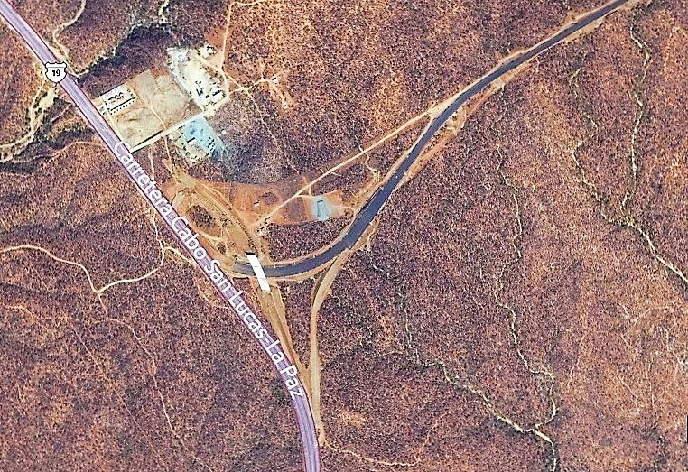
David K
Honored Nomad
Posts: 64532
Registered: 8-30-2002
Location: San Diego County
Member Is Offline
Mood: Have Baja Fever
|
|
Here is the west end interchange under construction:
|
|
|
MMc
Super Nomad
Posts: 1679
Registered: 6-29-2011
Member Is Offline
Mood: Current
|
|
| Quote: Originally posted by dtbushpilot | | Quote: Originally posted by MMc |
I do not want to start anything here. DK, why do you need a map? Do you fly in to out out of Los Cabos? It's not on google or bling? How does this
affect you or is it another data point?
The folks that live there seem to know about it.
| Quote: Originally posted by David K | I need a map!
New Todos Santos airport road??
Not a new airport... but a new road to the Los Cabos Int'l. Airport?
Over the mountain like the Naranjas Road, in place of it? |
[Edited on 10-2-2015 by MMc] |
Yes you do..... |
dtbushpilot, have a nice day.
[Edited on 10-3-2015 by MMc]
"Never teach a pig to sing it frustrates you and annoys the pig" - W.C.Fields
|
|
|
David K
Honored Nomad
Posts: 64532
Registered: 8-30-2002
Location: San Diego County
Member Is Offline
Mood: Have Baja Fever
|
|
Wondering if that helped Bajahowodd find the new road on satellite images? I used Bing Maps/ Aerial & Bird's Eye view formats for that one. Bing
has had newer satellite images than Google earth in many cases.
|
|
|
pauldavidmena
Super Nomad
Posts: 1691
Registered: 5-23-2013
Location: Centerville, MA, USA
Member Is Offline
|
|
Google Street View is showing images from July 2009, when Highway 19 was still a 2-lane road. That might explain it!
|
|
|
| Pages:
1
2 |