wilderone
Ultra Nomad

Posts: 3779
Registered: 2-9-2004
Member Is Offline
|
|
Wanna backpack to Sta. Maria mission next week?
Been planning this trip, and just thought someone might want to join me. It's 15 mi. one way; planning to take 6 days total. Leaving from San Diego.
U2U for more details, or questions.
[Edited on 11-3-2015 by wilderone]
|
|
|
David K
Honored Nomad
Posts: 64490
Registered: 8-30-2002
Location: San Diego County
Member Is Offline
Mood: Have Baja Fever
|
|
Have fun in there Cindy! It is definitely not a Subaru OK road! I think if you stay in the arroyo, it is a more pleasant hike the first few miles?
Some day those end walls will fall and it will be far less photogenic.
|
|
|
StuckSucks
Super Nomad
Posts: 2307
Registered: 10-17-2013
Member Is Offline
|
|
Hey David, do you have a lat/lon for this mission?
|
|
|
wilderone
Ultra Nomad
Posts: 3779
Registered: 2-9-2004
Member Is Offline
|
|
"... not a Subaru OK road"
which is why I'm backpacking. 2nd trip for me.
The mission remnant is a destination for base camp. Petroglyphs on the hill, have a Google earth view east of there to explore (indigenous
habitation?), hike down the cliff to the river - soak in the pools, and find other pools to the NE. Lots to enjoy, easy trail, water availability.
|
|
|
David K
Honored Nomad
Posts: 64490
Registered: 8-30-2002
Location: San Diego County
Member Is Offline
Mood: Have Baja Fever
|
|
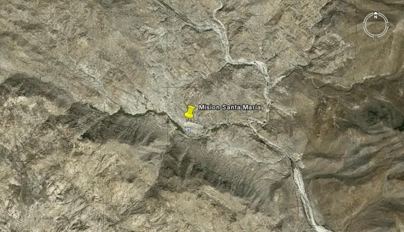
Nearly all mission GPS and satellite images are in the 4th section of my Baja Missions web pages. They begin at http://vivabaja.com/bajamissions
The Satellite/ GPS page is http://vivabaja.com/missions4
Here is Santa María:
SANTA MARIA 29°43'54.50" 114°32'50.16" Located 14.5 miles from
Rancho Santa Ynez over an extreme 4WD road.
|
|
|
StuckSucks
Super Nomad
Posts: 2307
Registered: 10-17-2013
Member Is Offline
|
|
GREAT mission resource, thanks!
|
|
|
StuckSucks
Super Nomad
Posts: 2307
Registered: 10-17-2013
Member Is Offline
|
|
Thanks again. Slight correction, should be:
SANTA MARIA 29°43'54.50" -114°32'50.16"
(placing longitude in the western hemisphere)
|
|
|
StuckSucks
Super Nomad
Posts: 2307
Registered: 10-17-2013
Member Is Offline
|
|
I see - the road actually heads east, right out of Santa Ynez. Looks fun.
|
|
|
motoged
Elite Nomad
Posts: 6481
Registered: 7-31-2006
Location: Kamloops, BC
Member Is Offline
Mood: Gettin' Better
|
|
Yes....the road was a challenge on a dirt bike several years ago.....no water between Rancho St Inez and the bottom of the Widowmaker hill....but a
ride I would do again...
This vid looks like the Widowmaker had been "cleaned up" at minute 1:32:
https://www.youtube.com/watch?v=k46uFVwO2eY
Don't believe everything you think....
|
|
|
David K
Honored Nomad
Posts: 64490
Registered: 8-30-2002
Location: San Diego County
Member Is Offline
Mood: Have Baja Fever
|
|
Yes, that is BajaRoadRunner who is a Nomad (from Tijuana, I think?)... Nice video down and back up the Widowmaker! Cool that the grade name stuck
since the trip in 1999 when I named it! Both BajaMur and I fell off our rides when climbing back up it... I was on a quad and Murrey (who was an
experienced m/c rider was on a m/c. That trip made up my very first web page for DavidKsBaja, since renamed VivaBaja:
Mission Santa Maria trip pages:
1999: http://www.vivabaja.com/missionsm/index.html
2003: http://www.vivabaja.com/403/
2007: http://vivabaja.com/msm/
2010: http://vivabaja.com/msm2010/
|
|
|
David K
Honored Nomad
Posts: 64490
Registered: 8-30-2002
Location: San Diego County
Member Is Offline
Mood: Have Baja Fever
|
|
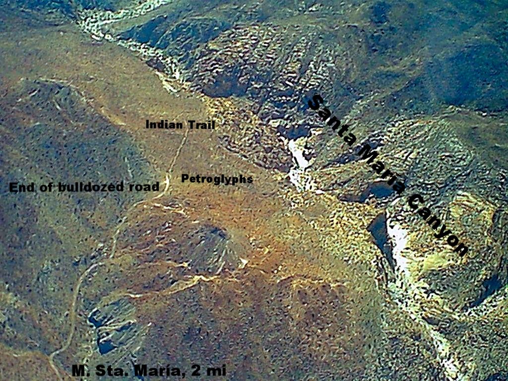
Here's a photo from BajaMur when we flew over Mission Santa María area in Doug Bowles plane, out of Alfonsina's in May 1999. The day or two before we
had ridden a motorcycle and a quad to the mission from Santa Ynez.
I added labels to the photo to point out points.
The bulldozed road was built by Fred Hampe (of Rancho Santa Ynez) in an attempt to get to Punta Final on the gulf coast (also owned by Rancho Santa
Ynez, then).
Once Fred reached the rim of the canyon, the impossibility of continuing must have sunk in?
The petroglyps are on a couple rocks at the top of the Indian Trail/ End of Road. The trail is how hikers get down to the waterfall fed pools seen in
photos.
The "Indian Trail" was the first El Camino Real used by the Jesuits and Franciscans. Coming up the canyon from Gonzaga was so dangerous, Junípero
Serra ordered a new trail built that stayed out of the canyon and up along the north rim. It meets the Fred Hampe road just below the edge of the
photo.
A second trail was also constructed from the mission warehouse on Bahía San Luis Gonzaga going west to serve new Mission San Fernando. Some of it is
visible on Google Earth. It meets the Santa Ynez/Santa María road just east of the peninsular divide (about 4 miles from Santa María).
|
|
|


