| Pages:
1
2
3
4
..
10 |
StuckSucks
Super Nomad

Posts: 2307
Registered: 10-17-2013
Member Is Offline
|
|
| Quote: |  |
I've taken thousands of this photo all around Baja - ahhhh ...
|
|
|
Gulliver
Senior Nomad
Posts: 651
Registered: 11-18-2013
Member Is Offline
|
|
Dunno if this the right place for this but the info may well help with planning. I accidentally dumped it on Wiily Airstream's Balanza thread.
============================
Trip report on San Remundo Canyon. 12-11-2015
I made it through to San Juanico, thence down to Purisma and San Isidro and back over the hill to Rt. 1 and then back home to Mulege. 220 miles from
7:15 a.m. to 5:50 p.m. Rode conservatively (solo riding is a poor idea) and paused a lot. Six hours from Mulege to San Juanico.
I'm way too knackered to post anything useful just yet. I've got my blood to Ibuprofen ratio adjusted for the evening and will organize my data,
pictures and observation in a post.
That said, the rains have not deal kindly with the Raymond Canyon part at all. Even allowing for such factors such as a 72 year old rider on a 20 year
old bike and being only a day past a case of stomach flu, it was a tight and rough ride through there. There was a several mile stretch where my
tracks were the first since the rains this Summer. Locals on both sides of the washed out part said that they regarded it as not worth it. Right now,
I concur.
Map problem:
Both the Baja California Almanac and the AAA map are wildly out of date as you drive South from San Juanico to Purisma.
The new road (already much damaged by Odile) does NOT follow the old route directly to Purisma. In fact, that old road is all blocked by construction
at the North end where it must have left the pavement headed inland. The pavement heads to Las Barrancas via the forgetable and invisible village of
San Gregorio and then, a few miles South of Los Barrancas arrives at a T intersection where you go right to Constitution and left to Purisma. Nice and
fast but 20+ miles further.
All of my whining is a bit like critiquing the performance of a dog walking on its hind legs. I should stop complaining about the stye and be dazzled
that it can do it at all. Mexican roads and the fantasies that show up on paper are just part of the experience though I was practicing some low words
in Spanish as I was sorting all of this out today.
David. Maybe a good place here for your corrected map?
|
|
|
David K
Honored Nomad
Posts: 64490
Registered: 8-30-2002
Location: San Diego County
Member Is Offline
Mood: Have Baja Fever
|
|
Quote: Originally posted by Gulliver  |
Map problem:
Both the Baja California Almanac and the AAA map are wildly out of date as you drive South from San Juanico to Purisma.
The new road (already much damaged by Odile) does NOT follow the old route directly to Purisma. In fact, that old road is all blocked by construction
at the North end where it must have left the pavement headed inland. The pavement heads to Las Barrancas via the forgetable and invisible village of
San Gregorio and then, a few miles South of Los Barrancas arrives at a T intersection where you go right to Constitution and left to Purisma. Nice and
fast but 20+ miles further.
David. Maybe a good place here for your corrected map?
|
Jaun del Rio posted this photo advertising the new highway route, in 2008:
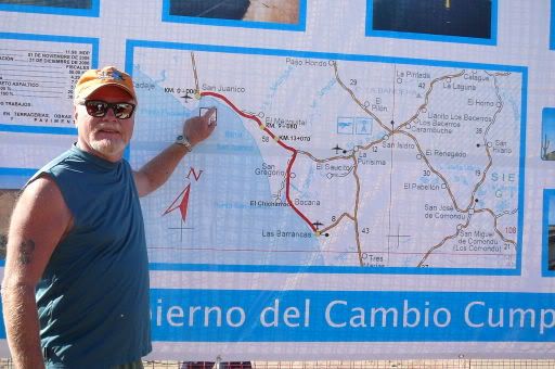
I transferred that onto the Almanac map:
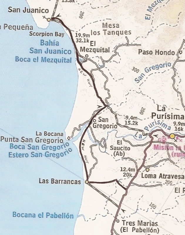
In 2011, it was reported all done!
Use Google Earth to see the actual route of the paved road. It is slightly different than the government map showed in 2008. Edit: Bing Maps/ Bird's
Eye View is newer imaging and shows the full highway from San Juanico south to Las Barrancas.
Here is a follow up post from April 2011:
Here is the new road south from San Juanico... I drew onto the AAA map from what I could see on Google Earth satellite photos of the new highway. Just
extend the pavement on to Las Barrancas from where Google showed it ending...

This was one of the maps I made to show Mike's trek.
[Edited on 12-13-2015 by David K]
|
|
|
TMW
Select Nomad
Posts: 10659
Registered: 9-1-2003
Location: Bakersfield, CA
Member Is Offline
|
|
| Quote: Originally posted by Gulliver |
Map problem:
Both the Baja California Almanac and the AAA map are wildly out of date as you drive South from San Juanico to Purisma.
The new road (already much damaged by Odile) does NOT follow the old route directly to Purisma. In fact, that old road is all blocked by construction
at the North end where it must have left the pavement headed inland. The pavement heads to Las Barrancas via the forgetable and invisible village of
San Gregorio and then, a few miles South of Los Barrancas arrives at a T intersection where you go right to Constitution and left to Purisma. Nice and
fast but 20+ miles further.
|
The old road turn off to La Purisima is at KM10 as I recall. The last time I was on that road was April of 2014 and there was a lot of rain damage
then. Maybe they are going to grade it and clean it up. Nice shortcut compared to going down to Los Barrancas and around on the paved hwy.
I just looked at Google Earth and it does not show the completed hwy. GE is dated 3-7-2010 for that area.
As a note the hwy was completed before April of 2013 as my friends and I used it then.
[Edited on 12-13-2015 by TMW]
|
|
|
David K
Honored Nomad
Posts: 64490
Registered: 8-30-2002
Location: San Diego County
Member Is Offline
Mood: Have Baja Fever
|
|
Hi Tom, check out BING MAPS, Bird's Eye View... the highway is all complete. Looks like instead of a bridge over Arroyo La Purísima, it is a long
concrete vado? Not very useful during floods!
|
|
|
TMW
Select Nomad
Posts: 10659
Registered: 9-1-2003
Location: Bakersfield, CA
Member Is Offline
|
|
When we were there in 2013 there was damage to the new hwy from the rains.
|
|
|
Gulliver
Senior Nomad
Posts: 651
Registered: 11-18-2013
Member Is Offline
|
|
Even more from Odile. The significant damage is nearer to San Juanico and consists of places where the pavement was undermined and then caved in.
Blocks perhaps half of a lane at a time max. But poorly marked if at all. Big problem at night if you are fool enough to be there at such a time!
None of this will impact any rally we might plan.
|
|
|
motoged
Elite Nomad
Posts: 6481
Registered: 7-31-2006
Location: Kamloops, BC
Member Is Offline
Mood: Gettin' Better
|
|
Things change w/roads with storms....nothing new there.
We are a year away from the potential Big Loop Rally.....so lots of time to consider joining, how a Nomad wants to do it....and there will likely be
up-to-date road intel after the 2016 fall storms.
Some folks have already offered GPS tracks for sections I have proposed....possible updates to them will give us all good "the track is somewhere
around here" opportunities 
https://www.youtube.com/watch?v=u9H0TbWm3JA
What we have here at this time is an armchair rally....it will be fun to watch it morph and take form....
Some planning/prep considerations... 
https://www.youtube.com/watch?v=Q4g3BauJmOw
[Edited on 12-13-2015 by motoged]
Don't believe everything you think....
|
|
|
AKgringo
Elite Nomad
Posts: 5818
Registered: 9-20-2014
Location: Anchorage, AK (no mas!)
Member Is Offline
Mood: Retireded
|
|
Neither of these links worked for me. Anyone else have a problem, or is it just on my end?
If you are not living on the edge, you are taking up too much space!
"Could do better if he tried!" Report card comments from most of my grade school teachers. Sadly, still true!
|
|
|
motoged
Elite Nomad
Posts: 6481
Registered: 7-31-2006
Location: Kamloops, BC
Member Is Offline
Mood: Gettin' Better
|
|
First link fix....getting lost....:
https://www.youtube.com/watch?v=u9H0TbWm3JA
[Edited on 12-13-2015 by motoged]
Don't believe everything you think....
|
|
|
AKgringo
Elite Nomad
Posts: 5818
Registered: 9-20-2014
Location: Anchorage, AK (no mas!)
Member Is Offline
Mood: Retireded
|
|
Thanks for the fix!
[Edited on 12-13-2015 by AKgringo]
If you are not living on the edge, you are taking up too much space!
"Could do better if he tried!" Report card comments from most of my grade school teachers. Sadly, still true!
|
|
|
Gulliver
Senior Nomad
Posts: 651
Registered: 11-18-2013
Member Is Offline
|
|
Anyone riding big bikes like that through Raymond Canyon deserves what will happen to them. i.e. leaving the bike and walking out if they don't get
stuck under it!
The biggest problem I saw up there on Friday would be with buggies as there were a few places where you needed to get in and out of a water crossing
through some relatively deep sand. Narrow front tires might be a problem. With two rigs and a tow rope you would make it with some laughs. Just got to
nail it and kamikaze through. You WILL get wet from the splashing. No water much over axle deep. 18"?
Purisma to Rt. 1 is fine. 30 miles of scrabbling over some rocks followed by 10 miles of riding too fast. Don't ask. I missed the goats though.
|
|
|
motoged
Elite Nomad
Posts: 6481
Registered: 7-31-2006
Location: Kamloops, BC
Member Is Offline
Mood: Gettin' Better
|
|
Gulliver,
Congrats on riding there....shortly after being sick....
I remember one ride from Mulege to Juanico and back in a day with a serious case of the squirts....no fun....but numerous stops along the way... (squatting with dirt bike boots doesn't allow pants below the knee...gotta
be careful )
Those "big bikes" are 450's w/ navigation towers and big tanks...
My first ride between Mulege and San Juanico was on my GS 1100 in 2001.....won't do that again....most others on 450 and once on 690.
Don't believe everything you think....
|
|
|
Gulliver
Senior Nomad
Posts: 651
Registered: 11-18-2013
Member Is Offline
|
|
The riding in Baja is so variable that it's hard to recommend a perfect bike. If you need to cover ground on the pavement, I'd recommend a Gold Wing
or a car. If you want to go rock crawling and check out wonderful hell holes like Crybaby Canyon, an observed trails bike or a helicopter are the way
to go.
Right now I tend to poke around in fairly horrid places but make my run for the barn on the pavement or smooth roads so my Suzuki 350 works for me. I
can change sprockets in a few minutes.
My partner's Yamaha XT-225 is looking better and better.
I don't know squat about four wheeled vehicles. I have seen these Razr's and kindred rigs in some rough places. They seem pricey and maybe not so
useful for other things.
Wanna go fast for reasonable bucks, buy an old buggy like Wiilyairstream runs. The locals are big on old japanese pickups and Ford full sized F-150
4WD. They go everywhere with those beasts!!!
|
|
|
sarkmych
Newbie
Posts: 7
Registered: 11-13-2009
Member Is Offline
|
|
Following..... ill pm you Ged.
|
|
|
Hook
Elite Nomad
Posts: 9006
Registered: 3-13-2004
Location: Sonora
Member Is Offline
Mood: Inquisitive
|
|
What IS the minimum capable vehicle for the route described by motoged in his first post? Will a Jeep with an open diff, unlifted, with BFG TA KO2s
make it?
I know, hard to predict with plenty of rain betweeen now and winter 2017. But, assuming the conditions that exist right now, what is the minimum
vehicle that could make this without TOO much damage? LOL! Import 4wd trucks? Long bed 4wd trucks? Samurais? Trackers? 4wd SUVs? Baja bugs?
I assume any ATV, UTV, sand rail or dune buggy would be OK?
|
|
|
motoged
Elite Nomad
Posts: 6481
Registered: 7-31-2006
Location: Kamloops, BC
Member Is Offline
Mood: Gettin' Better
|
|
Hook,
1) Mulege to San Juanico: Jeep for sure could do it....Mexican ranchero's 2 wheel drive also OK.....so, anything w/ enough rough road experience is
OK
2) Juanico to La Purisima/San Isidro.....anything works...mostly paved
3) San Isidro to Mulege (Willy Airstream and Mulege Al's recent comments indicate shorter wheelbase w/ 4X4 ) is very challenging...but no
road-building needed at this time....just rough, loose, and steep in places
4) San Isidro to Hwy 1 (south end of Bahia Concepcion) is a good rough road....any vehicle
5) San Isidro to Commondu....maybe need 4X4 for a few short sections....mostly rough road
6) Commondu to San Javier probably need 4X4, but I have not been on that road except for 10 kms off San Javier main road....storms have torn it up
over the past few years...but hardcore types have done it w/ 4 wheeled vehicles
7) Hwy 1 to San Nicholas to Mulege..... any 4x4 would have no problem
Those are my estimates....
My original route suggestion offers numerous bailout points (all which would get you back to Mulege that or the next day) as well as hardcore
options for those inclined....
Road down( headed west) into San Isidro:

Only real rough part (100 feet) between San Isidro and Commondu:

Just north of Commondu heading to San Isidro....not too bad....

Don't believe everything you think....
|
|
|
Gulliver
Senior Nomad
Posts: 651
Registered: 11-18-2013
Member Is Offline
|
|
Before any plans will have been made, someone with four wheel experience will go check out the Mulege to San Juanico leg. I have no expertise on
anything but bikes.
On all of the rest except for the Comundu to San Javier road, I concur with the previous descriptions and photos. I rode up that road shown in the
first picture last Friday at 20-35 mph and passed several 2WD pickups with families along the way.
The Commando to San Javier road needs more recent checking out and maybe a pix or two of the rough spots. I was in there three years ago Northbound
solo riding and found the climb up from Palo Chino to be off camber with vertical steps that precluded me going on by myself. A low geared 4WD would
have done O.K. I suspect but I wished to ride out on my own wheels.
All of this suggested route is doable and will be fun in groups.
As a side observation, here are my two worst roads in Baja:
Second worst is the few miles in from Rancho Santa Ines to the mission. People are starting to get hurt in there. Ralph, at Santa Inez is the expert
on this little horror, I talk to him on ham radio every day. It is being done several times a year but I advise prudence and serious self rescue
capabilities.
The worst is a route that I hesitate to mention because it will attract fools. It is known among the bike crowd as Crybaby Canyon. It once was a
negotiable route from Mission Guadalupe West of Mulege over the mountains West to San Juan de la Pila. It was negotiated last year by a small group of
bikes who wanted to spread the ashes of their compatriot who named it some years before by falling on his back and requesting that his next of kin be
notified. Subsequently he passed away from ordinary causes.
Is road is gone. In the words of Monte Python it is a dead parrot. They took ten hours to cover five miles and most of it required all of them to lift
one bike at a time over man sized boulders. I have a picture and will share it when I sort out that skill. I took them to the entrance and rode back
to Mulege expecting to never hear of them again. They made to Rice and Beans at San Ignatio that night and I think that the will not try that route
again.
There are limits. This one needs a D8 cat or a helicopter.
[Edited on 12-14-2015 by Gulliver]
|
|
|
motoged
Elite Nomad
Posts: 6481
Registered: 7-31-2006
Location: Kamloops, BC
Member Is Offline
Mood: Gettin' Better
|
|
Gulliver,
I rode solo into Santa Maria (to top of Widowmaker hill) on my 450 in 2010...met Ralph by the goat corral just east of the Rancho Inez ...have helmet
cam video both ways...
IN 2011, 9 of us from Kamloops drove a bus down to San Ignacio where I joined up with DT Bushpilot for our first meeting....We all rode over through
San Juan de las Pila to Mulege....DT and I on loaded on 690's with camping-gear ....DT and I did our own ride after Mulege for a week while the rest
of the guys rode to the tip and back...on their way back they were the first dirtbikers to EVER ride from just south of Santa Rosalia through to San
Ignacio...
My ride report for that trip: Commondu, etc
http://www.advrider.com/forums/showthread.php?t=666961
[Edited on 12-14-2015 by motoged]
Don't believe everything you think....
|
|
|
David K
Honored Nomad
Posts: 64490
Registered: 8-30-2002
Location: San Diego County
Member Is Offline
Mood: Have Baja Fever
|
|
The top of the Widowmaker is where the fun really begins! Especially in 2010 when the water bog below was 2-3 feet deep! You were less than 2 miles
from the mission from up there: http://vivabaja.com/msm2010/
|
|
|
| Pages:
1
2
3
4
..
10 |


