David K
Honored Nomad

Posts: 64480
Registered: 8-30-2002
Location: San Diego County
Member Is Offline
Mood: Have Baja Fever
|
|
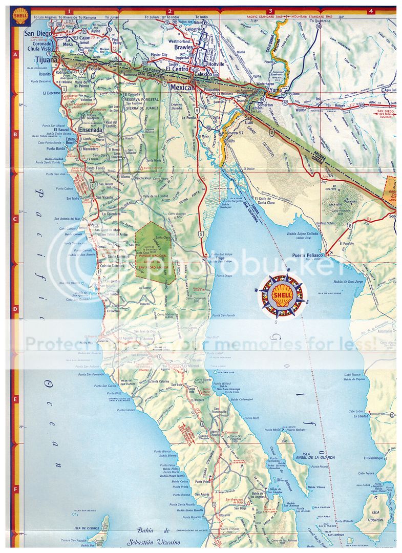
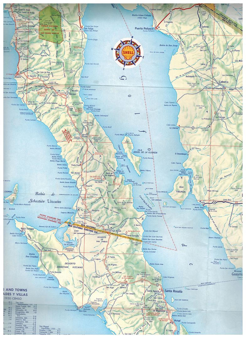
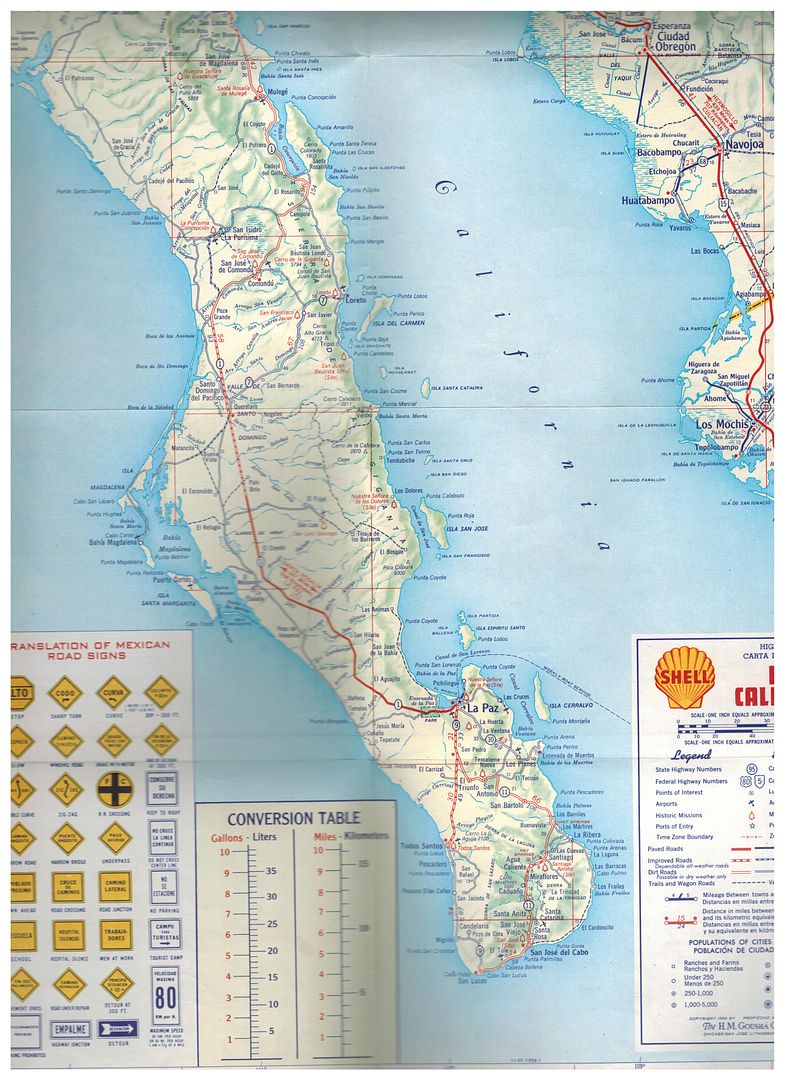
1958 Shell Oil Map of Baja, quite good detail!
I saw this on Facebook by an Internet friend and I asked if he would send me the files to share with other Baja enthusiasts. Here are the three
scans...
I can do close ups of any part, just ask for the area of interest. There is a blurry section, unavoidable along the road north of La Paz towards
Comondu... Magdalena Plain and Bay area.
|
|
|
David K
Honored Nomad
Posts: 64480
Registered: 8-30-2002
Location: San Diego County
Member Is Offline
Mood: Have Baja Fever
|
|
It studying the details, it would seem the data was collected about 1955-56.
The road from Loreto to San Javier and on to Santo Domingo was just built (and the map calls that Highway 7).
The long straight new highway north from La Paz is done, but no town of Constitucion or El Crucero yet shown. Of course, before 1972, the main
transpeninsular route (#1) did pass through Comondú and not Loreto.
No Guerrero Negro (Salina Vizcaino) yet to show, and the main road went through El Arco until 1973. Pavement south from Ensenada ended at Arroyo Seco,
near Colonet right to about 1970.
The road south from San Felipe did go to the sulfur mine then swing east to the beach and well of Agua de Chale. No road south other than fresh Jeep
tracks or driving the beach.
No Puertecitos (or Gonzaga) road or full-time population yet. That trail didn't exist as shown to El Marmol... only between Marmol and Miramar for the
gold/onyx mine communication.
Otherwise, the accuracy is quite good of the details.
|
|
|
AKgringo
Elite Nomad
Posts: 5809
Registered: 9-20-2014
Location: Anchorage, AK (no mas!)
Member Is Offline
Mood: Retireded
|
|
It is surprising to me that Shell would issue a map for an area that they had no stations!
[Edited on 12-22-2015 by AKgringo]
If you are not living on the edge, you are taking up too much space!
"Could do better if he tried!" Report card comments from most of my grade school teachers. Sadly, still true!
|
|
|
TMW
Select Nomad
Posts: 10659
Registered: 9-1-2003
Location: Bakersfield, CA
Member Is Offline
|
|
David I have a 1958 and a 1960 Shell Baja map. Also a 1962 Richfield Mexico and Baja California map. The 1960 and 1962 maps show the hwy 5 road out to
hwy 1 north of Chapala like where the turquesa mine road runs.
|
|
|
TMW
Select Nomad
Posts: 10659
Registered: 9-1-2003
Location: Bakersfield, CA
Member Is Offline
|
|
I have a 1972 AAA Baja map that shows the hwy from Ensenada past Valle de Trinidad is Hwy 16 and the Hwy to LA Bay is Hwy 1. From Constitucion to San
Carlos is Hwy 4. From Todos Santos to Hwy 1 is Hwy 9. So somewhere along the way Mexico re-numbered several highways.
Or maybe AAA had it wrong.
[Edited on 12-22-2015 by TMW]
|
|
|
David K
Honored Nomad
Posts: 64480
Registered: 8-30-2002
Location: San Diego County
Member Is Offline
Mood: Have Baja Fever
|
|
No, Mexico changed the #s. The Ensenada to San Felipe road when paved (completed about 1977/78) was BC 16. When the feds took it over and gave it the
SAME name as the Tecate to Ensenada highway (built around 1960), that was insane (I thought).
|
|
|
David K
Honored Nomad
Posts: 64480
Registered: 8-30-2002
Location: San Diego County
Member Is Offline
Mood: Have Baja Fever
|
|
Quote: Originally posted by TMW  | | David I have a 1958 and a 1960 Shell Baja map. Also a 1962 Richfield Mexico and Baja California map. The 1960 and 1962 maps show the hwy 5 road out to
hwy 1 north of Chapala like where the turquesa mine road runs. |
Just inaccurate road placement.
The Shell map is so well done (except for the trail south from the sulfur mine part)... I expected to see Howard Gulick's name on it!
|
|
|
David K
Honored Nomad
Posts: 64480
Registered: 8-30-2002
Location: San Diego County
Member Is Offline
Mood: Have Baja Fever
|
|
| Quote: Originally posted by AKgringo | It is surprising to me that Shell would issue a map for an area that they had no stations!
[Edited on 12-22-2015 by AKgringo] |
There were Shell, Standard Oil and Union gas stations in Baja. I remember seeing some signage still, in the 1960's (at Pemex stations that took over
the buildings or gravity pumps). Pemex was created in 1938, but Baja was probably last to lose the U.S. (Standard & Union Oil) and Dutch (Shell)
gas stations?
|
|
|


