| Pages:
1
2 |
Zola
Nomad

Posts: 122
Registered: 9-7-2014
Location: San Juanico, Point Loma
Member Is Offline
Mood: Enthusiastic
|
|
San Juanico -San Ignacio: The High Road
Traveling north from San Juanico on December 2, we mistakenly stayed on the high road rather turn left for Campo Datil. Big mistake. I should have
turned back to look for the road to Datil. The high road in parts feels as though it was recently graded, but it has some treacherous spots that I
will not willingly drive again. Overall, it was much different from what it was like when I took it perhaps 2-3 years ago. In places I had to keep
composed and drive very carefully, lest it be the last thing any of us ever did! Only one other time have I had the same feeling -- when I took the Ho
Chi Minh trail to get to Black's beach: I promised myself that time that if I survived the trail, I would never willingly take it again! But maybe I
am just a wuss.
It is however driveable if you have a very sturdy 4 X 4 with high clearance, and I suppose the plus side is that the underside of your vehicle will
not collect as much salt. No one else seems to be driving it however. We didn't see a single vehicle until we reached the road that runs from the
Laguna to San Ignacio. The people at the ranch were as nice and helpful as ever. I think they have seen far fewer motorists coming their way lately,
or perhaps none at all, except for us. If you were to break down out there, you might just have to start walking to find help.
Otherwise, there was a little water at la Ballena, and the north roads are driveable. The rest of the drive was pleasant and easy. We drove at 10-15
mph most of the way from Chapala to the paved 5. There were surprisingly strong winds on the 5 in the mountains and also fallen rocks, but none that
fell on us!
[Edited on 12-26-2015 by Zola]
Sometimes the questions are complicated and the answers are simple. Dr. Seuss
Never wrestle with pigs. You both get dirty and the pig likes it. George Bernard Shaw
|
|
|
TMW
Select Nomad
Posts: 10659
Registered: 9-1-2003
Location: Bakersfield, CA
Member Is Offline
|
|
When I was thru there in April the rancher at El Cuarenta told me to go west not north at the jct after his ranch as the north route had been damaged
by the rains. It was a pretty rough route until we got to the road to El Datil.
|
|
|
Zola
Nomad
Posts: 122
Registered: 9-7-2014
Location: San Juanico, Point Loma
Member Is Offline
Mood: Enthusiastic
|
|
Yes, when we came down we took the middle road to Campo Datil. Everything was fine until we traveled from Datil to SJ, where the route was strewn with
boulders and holes, but it was manageable. The high road is barely manageable if you are feeling lucky! I will not knowingly take it again
until further notice!
[Edited on 12-26-2015 by Zola]
Sometimes the questions are complicated and the answers are simple. Dr. Seuss
Never wrestle with pigs. You both get dirty and the pig likes it. George Bernard Shaw
|
|
|
David K
Honored Nomad
Posts: 65560
Registered: 8-30-2002
Location: San Diego County
Member Is Offline
Mood: Have Baja Fever
|
|
Quote: Originally posted by Zola  | Yes, when we came down we took the middle road to Campo Datil. Everything was fine until we traveled from Datil to SJ, where the route was strewn with
boulders and holes, but it was manageable. The high road is barely manageable if you are feeling lucky! I will not knowingly take it again
until further notice!
[Edited on 12-26-2015 by Zola] |
Thanks for the report. Did you record how far south from San Ignacio the pavement has reached?
|
|
|
AKgringo
Elite Nomad
Posts: 6351
Registered: 9-20-2014
Location: Anchorage, AK (no mas!)
Member Is Offline
Mood: Retireded
|
|
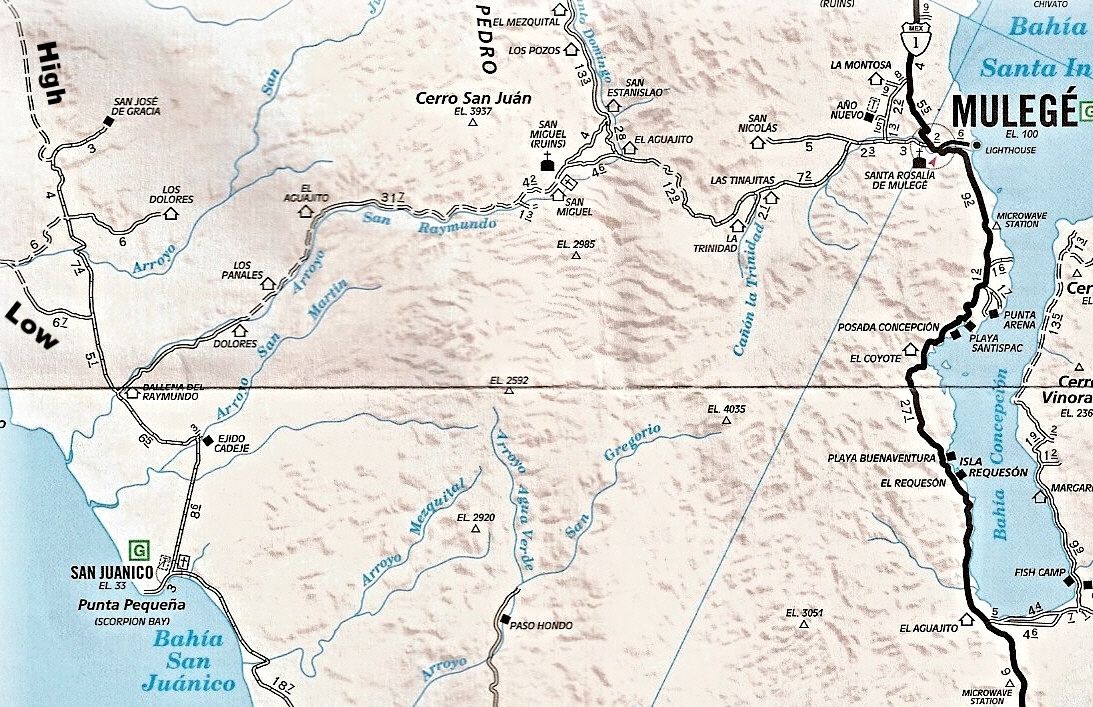
Two years ago, I tried to find my way north through San Juanico to Laguna San Ignacio, and got all kinds of turned around! As far as I can
reconstruct my route, I believe I not only missed the low road, but the high road as well.
I believe I took the fork to San Jose De Gracia (shown on the map DK posted) and wound up following a ranch road through a variety of conditions. A
few spots were rugged, and I was in low range a couple of times, but I never had to put my hubs in.
When I finally got on to a fairly good road, I came across a crew doing some repairs and improvements to a water crossing, I showed them my map (AAA),
They told me I was at El Patrocino, and that there was no road where I had just come from!
Zola, I may have met you at the Cantina on the hill where I camped at San Juanico. Do you travel with a small pack of rescue dogs? If so, you were
right when you told me I was gonna get lost if I didn't travel with someone who knows the way! I was driving a Small SUV and had an old black dog
with a white chest and paws.
If you are not living on the edge, you are taking up too much space!
"Could do better if he tried!" Report card comments from most of my grade school teachers. Sadly, still true!
|
|
|
PaulW
Ultra Nomad
Posts: 3113
Registered: 5-21-2013
Member Is Offline
|
|
| Quote: Originally posted by David K | | Quote: Originally posted by Zola | Yes, when we came down we took the middle road to Campo Datil. Everything was fine until we traveled from Datil to SJ, where the route was strewn with
boulders and holes, but it was manageable. The high road is barely manageable if you are feeling lucky! I will not knowingly take it again
until further notice!
[Edited on 12-26-2015 by Zola] |
Thanks for the report. Did you record how far south from San Ignacio the pavement has reached? |
=====
Pavement ends at the beginning of the dike road
Drove the high road (Actually we call it the middle road) YESTERDAY
[Edited on 12-26-2015 by PaulW]
|
|
|
David K
Honored Nomad
Posts: 65560
Registered: 8-30-2002
Location: San Diego County
Member Is Offline
Mood: Have Baja Fever
|
|
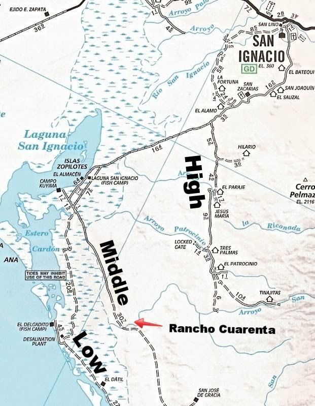
A road (not shown) connects the High Road to the Middle Road at Rancho Cuarenta. The Middle Road then become the High Road on south.
|
|
|
David K
Honored Nomad
Posts: 65560
Registered: 8-30-2002
Location: San Diego County
Member Is Offline
Mood: Have Baja Fever
|
|
| Quote: Originally posted by PaulW | | Quote: Originally posted by David K | | Quote: Originally posted by Zola | Yes, when we came down we took the middle road to Campo Datil. Everything was fine until we traveled from Datil to SJ, where the route was strewn with
boulders and holes, but it was manageable. The high road is barely manageable if you are feeling lucky! I will not knowingly take it again
until further notice!
[Edited on 12-26-2015 by Zola] |
Thanks for the report. Did you record how far south from San Ignacio the pavement has reached? |
=====
Pavement ends at the beginning of the dike road
Drove the high road (Actually we call it the middle road) YESTERDAY
[Edited on 12-26-2015 by PaulW] |
What (where) is the dike road? How far from a point on the AAA map so I can add the pavement to it?
|
|
|
TMW
Select Nomad
Posts: 10659
Registered: 9-1-2003
Location: Bakersfield, CA
Member Is Offline
|
|
| Quote: Originally posted by AKgringo | Two years ago, I tried to find my way north through San Juanico to Laguna San Ignacio, and got all kinds of turned around! As far as I can
reconstruct my route, I believe I not only missed the low road, but the high road as well.
I believe I took the fork to San Jose De Gracia (shown on the map DK posted) and wound up following a ranch road through a variety of conditions. A
few spots were rugged, and I was in low range a couple of times, but I never had to put my hubs in.
When I finally got on to a fairly good road, I came across a crew doing some repairs and improvements to a water crossing, I showed them my map (AAA),
They told me I was at El Patrocino, and that there was no road where I had just come from!
|
If you go to Google Earth there is a road from San Jose De Gracia to El Patrocino. It's sometimes hard to see but I have traced it out based on
another persons travels.
|
|
|
Zola
Nomad
Posts: 122
Registered: 9-7-2014
Location: San Juanico, Point Loma
Member Is Offline
Mood: Enthusiastic
|
|
The pavement begins at the same place it began a year ago and two years ago. It seems to me that they are not extending it at all.
We took the road from San Juanico and missed the turn off to Campo Datil. We reached a sign. One way led to San Jose de Gracia. The other to the
Laguna. We took the road to the Laguna. It was a very treacherous stretch. We then reached a ranch, received further directions, and paid a tip. From
there there was only one place that was tricky, but it was very tricky. Then we came upon the road I have always called the high road, which led us to
the road from La Laguna to San Ignacio. We were laughing in relief by then.
Sometimes the questions are complicated and the answers are simple. Dr. Seuss
Never wrestle with pigs. You both get dirty and the pig likes it. George Bernard Shaw
|
|
|
mtgoat666
Platinum Nomad
Posts: 21081
Registered: 9-16-2006
Location: San Diego
Member Is Offline
Mood: Hot n spicy
|
|
| Quote: Originally posted by David K | | Quote: Originally posted by PaulW | | Quote: Originally posted by David K | | Quote: Originally posted by Zola | Yes, when we came down we took the middle road to Campo Datil. Everything was fine until we traveled from Datil to SJ, where the route was strewn with
boulders and holes, but it was manageable. The high road is barely manageable if you are feeling lucky! I will not knowingly take it again
until further notice!
[Edited on 12-26-2015 by Zola] |
Thanks for the report. Did you record how far south from San Ignacio the pavement has reached? |
=====
Pavement ends at the beginning of the dike road
Drove the high road (Actually we call it the middle road) YESTERDAY
[Edited on 12-26-2015 by PaulW] |
What (where) is the dike road? How far from a point on the AAA map so I can add the pavement to it? |
Not sure "dike" road is a good descriptor. The pavement ends about where the road enters the tidelands (mudflats). The road is constructed on fill
that crosses the tidelands. Maybe Zola is calling the elevated roadbed a "dike"
[Edited on 12-27-2015 by mtgoat666]
|
|
|
David K
Honored Nomad
Posts: 65560
Registered: 8-30-2002
Location: San Diego County
Member Is Offline
Mood: Have Baja Fever
|
|
It was Paul who said dike road. So has anyone recorded how many miles of pavement extend southbound from San Ignacio?
|
|
|
Zola
Nomad
Posts: 122
Registered: 9-7-2014
Location: San Juanico, Point Loma
Member Is Offline
Mood: Enthusiastic
|
|
I never monitored it, but I would say maybe 20-30 miles? Next time I will watch the odometer.
Sometimes the questions are complicated and the answers are simple. Dr. Seuss
Never wrestle with pigs. You both get dirty and the pig likes it. George Bernard Shaw
|
|
|
mtgoat666
Platinum Nomad
Posts: 21081
Registered: 9-16-2006
Location: San Diego
Member Is Offline
Mood: Hot n spicy
|
|
| Quote: Originally posted by David K | | It was Paul who said dike road. So has anyone recorded how many miles of pavement extend southbound from San Ignacio? |
It's paved like a bunch of miles, my precise measurement found that the pavement (X) is accurately described as 20<X<35 miles
Are we there yet?
Further!
[Edited on 12-27-2015 by mtgoat666]
|
|
|
TMW
Select Nomad
Posts: 10659
Registered: 9-1-2003
Location: Bakersfield, CA
Member Is Offline
|
|
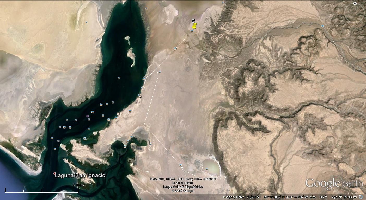
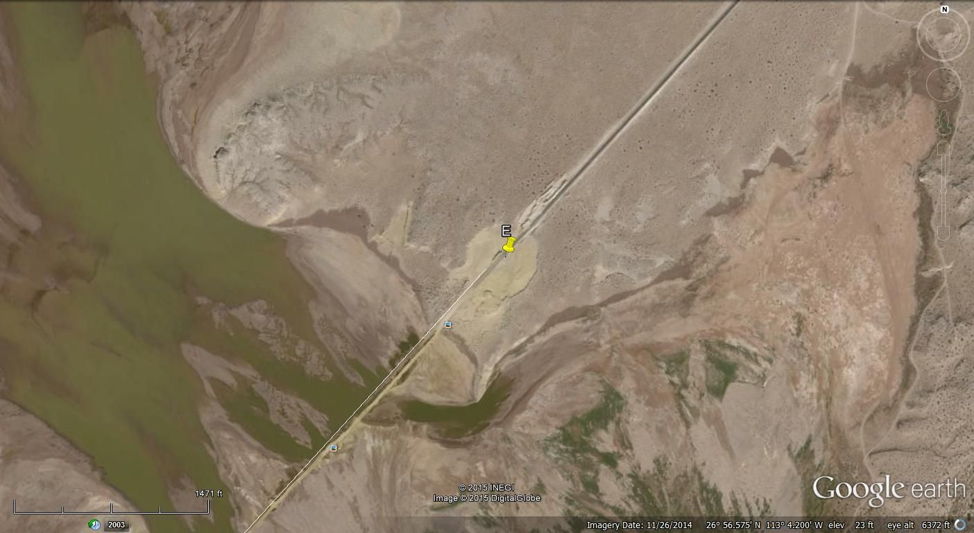
From these GE images dated Nov. 2014 they are about 4 miles from the fish camp. The E marker is at 26-56.57x113-04.20.
|
|
|
mcnut
Nomad
Posts: 177
Registered: 12-9-2013
Location: Dammeron Valley, UT
Member Is Offline
|
|
I believe the pavement on the road heading to the Laguna campos extends approximately 30 miles from the Mission ending at 26deg 56min 36sec, 113deg
04min 10sec. This is where the road finally enters the tidelands for extended periods.
Not sure it is a dike, more of an elevated or raised roadbed.
Bruce
|
|
|
mcnut
Nomad
Posts: 177
Registered: 12-9-2013
Location: Dammeron Valley, UT
Member Is Offline
|
|
Sorry for the redundant post Tom. Either it took me an hour to dig up or your post didn't display right away for me.
Bruce
|
|
|
PaulW
Ultra Nomad
Posts: 3113
Registered: 5-21-2013
Member Is Offline
|
|
I think there is hope for a better road south? The active gravel pit has been working quite a bit and the stock pile of gravel and mostly rocks is
huge. It is just north of the dike.
There are two sizable washouts on the pavement that are in good condition with good gravel/road base. Slowing is not required.
The dike road is lumpy and slow is required.
|
|
|
mcnut
Nomad
Posts: 177
Registered: 12-9-2013
Location: Dammeron Valley, UT
Member Is Offline
|
|
I suspect the focus is to pave to the Laguna Campos for the tourists.
Bruce
|
|
|
David K
Honored Nomad
Posts: 65560
Registered: 8-30-2002
Location: San Diego County
Member Is Offline
Mood: Have Baja Fever
|
|
As far back as 1973, a paved highway from San Ignacio south to join Hwy. 1 at Insurgentes had been proposed. This was to cut over 100 miles and two
steep grades for traffic north and south of those two towns.
The businesses of Santa Rosalia, Mulege and Loreto were not happy with losing all that potential business from the soon to open Transpeninsular
Highway. The plan was shelved, but pavement was extended from Insurgentes north to La Purísima and more recently to San Juanico. Close to half of the
distance with the road south from San Ignacio included.
[Edited on 12-28-2015 by David K]
|
|
|
| Pages:
1
2 |


