| Pages:
1
2
3
4
5 |
PaulW
Ultra Nomad

Posts: 3005
Registered: 5-21-2013
Member Is Offline
|
|
Some places I use on occasion
Hwy3
K159.8 - Slate mine & access to Arroyo Arrajal
Hwy 5
PMEX = k4, k4.8, k10.5, k15.6
BC4 update k38.3
K142 - 3 Poles
K142.8 - Salt mines
K149.3 - Curvitas wash (Clamaty)
K156.3 - 2 Poles
|
|
|
PaulW
Ultra Nomad
Posts: 3005
Registered: 5-21-2013
Member Is Offline
|
|
2 poles is the start finish for Pete's Poker run and other events for those who want to get out of town.
Also a major BFG pit for the 250
Typical rough road to the race track. Doable slowly for any car.
|
|
|
bajapedro
Nomad
Posts: 143
Registered: 3-2-2016
Member Is Offline
|
|
I'll just take a pic of these to keep in my phone along with 6 or so David K hand made maps, which have saved my butt on more than 1 occasion.
Thanks.
|
|
|
David K
Honored Nomad
Posts: 64476
Registered: 8-30-2002
Location: San Diego County
Member Is Offline
Mood: Have Baja Fever
|
|
San Felipe South Campos List Aug. 17, 2018
Here are all the campos that I could see signs for and their locations between Punta Estrella and Puertecitos. This list is followed by a revised one
with additions made by members of the South Campos Amigos Facebook page:
If I could see a sign, then I noted it... from Punta Estrella to Puertecitos. In many places ,the word 'Campo' was dropped from the name listed:
Km. 8.5 Villa Marina RV Park
Km. 11 La Jolla del Mar
Km. 12 Punta Estrella Beach
Km. 14+ Valle de los Gigantes
Km. 15.5 Pancho's
Km. 17 Rancho Los Potrillos
Km. 20.5+ Rancho Percebú
Km. 31 Bahía Santa María/ La Misión/ Playa Hermosa
Km. 31.5 Baja Beach Resort
Km. 32 Nuevo Mazatlán
Km. 32 El Sahuaro
Km. 33 Playa Linda
Km. 33.5 La Roca
Km. 34 Campo Delicias
Km. 34+ San Pedro
Km. 35+ El Vergel
Km. 35.5-36 Colonia Delicias
Km. 36.5 OM BAJA
Km. 36.5+ La Perlita
Km. 37.5 Diamante
Km. 37.5+ Santa Fe
Km. 38.5+ San Martin
Km. 39.5 Garcia
Km. 39.5+ Playa Mexico
Km. 40+ Rancho Anita
Km. 40.5 Cielito Lindo
Km. 40.5+ Agua Azul
Km. 41.5 Campo Cadena
Km. 42+ Campo Jimenez
Km. 42.5 Los Gorditos
Km. 43.5 Pelicano
Km. 44 Campo Badilla
Km. 45 Campo Adriana
Km. 45.5 Mar y Sol
Km. 45.5 Los Morritios
Km. 46 San José
Km. 47 Rudy's Camp
Km. 47.5 San Francisco
Km. 49 Los Pulpos
Km. 49+ Rancho Las Panteras (El Coloradito Parcela 55)
Km. 49.5 Consuelo (at curve in highway)
Km. 51.5 Playa El Sueño
Km. 52.5 Old Puertecitos Road (Score Race Route)
Km. 52.5+ Costa Verde
Km. 54.5 Playa Cristina
Km. 58.5 Los Olivos
Km. 60 Arroyo Matomí
Km. 60.5 El Pozo
Km. 61-72.5+ DETOUR for new highway work.
Km. 65 El Conquistador
Km. 68.5+ Zimarros
Km. 68.5+ La Violeta
Km. 72+ La Toba
Km. 73 Cow Patty
Km. 74.5 Puertecitos Road (Ocatcio's Playa Escondida access)
Revised list Km. 0 to Puertecitos:
Km. 0 Airport Road (6.1 miles from San Felipe traffic circle)
Km. 1 La Hacienda
Km. 6 San Fernando*
Km. 6.5 Residence "Camping" (El Faro Beach)
Km. 6.5+ La Perla del Mar*
Km. 8.5 Villa Marina RV Park.
Km. 9 Campo Lobo*
Km. 11 La Jolla del Mar
Km. 12 Punta Estrella Beach
Km. 14+ Valle de los Gigantes
Km. 15.5 Pancho's
Km. 17 Rancho Los Potrillos
Km. 20.5+ Rancho Percebu.
Km. 26+ Shell Island access road (4WD)
Km. 31 Bahía Santa María/ San Carlos*/ La Misión/ Playa Hermosa
Km. 31.5 Baja Beach Resort
Km. 32 Nuevo Mazatlán
Km. 32 El Sahuaro
Km. 32.5 La Joya*
Km. 33 Playa Linda
Km. 33.5 La Roca
Km. 34 Campo Delicias
Km. 34+ San Pedro.
Km. 35 Fire Station*
Km. 35+ El Vergel
Km. 35.5 Lupita*
Km. 35.5-36 Colonia Delicias (TOWN) See note D, below.
Km. 36 Esmeralda*
Km. 36.5 OM BAJA/ Punta Loma*
Km. 36.5+ La Perlita
Km. 37.5 Diamante
Km. 37.5+ Santa Fe
Km. 38.5+ San Martin
Km. 39.5 Garcia
Km. 39.5+ Playa Mexico
Km. 40+ Rancho Anita
Km. 40.5 Cielito Lindo
Km. 40.5+ Agua Azul
Km. 41.5 Campo Cadena
Km. 42+ Campo Jimenez
Km. 42.5 Los Gorditos
Km. 43 San Antonio*
Km. 43.5 Pelicano
Km. 44 Campo Badilla.
Km. 44.5 Playa Gabriela*
Km. 45 Campo Adriana
Km. 45.5 Mar y Sol
Km. 45.5 Los Morritios
Km. 46 San José
Km. 47 Rudy's Camp
Km. 47.5 San Francisco
Km. 49 Los Pulpos
Km. 49+ Rancho Las Panteras (El Coloradito Parcela 55)
Km. 49.5 Consuelo (at curve in highway)
Km. 51.5 Playa El Sueño
Km. 52.5 Old Puertecitos Road (Score Race Route)
Km. 52.5+ Costa Verde
Km. 54.5 Playa Cristina
Km. 58.5 Los Olivos
Km. 60 Arroyo Matomí
Km. 60.5 El Pozo
Km. 61-72.5+ DETOUR for new highway work.
Km. 65 El Conquistador
Km. 68.5+ Zimarros
Km. 68.5+ La Violeta.
Km. 70 Campo Cesar*
Km. 72+ La Toba
Km. 73 Cow Patty
Km. 74.5 Puertecitos Road (Octavio's Playa Escondida access)
note D*: In Colonia Delicias is Chelo's Restaurant, South Campos Community Center, Marino’s Restaurant, Josefina’s Laundry and Car Wash, Tita’s
Taco Tuesday Restaurant, Aniceto's Restaurant, Police Station, Amazona Market
* = Edits added from Facebook members
|
|
|
Lee
Ultra Nomad
Posts: 3455
Registered: 10-2-2006
Location: High in the Colorado Rockies
Member Is Offline
|
|
Roadguide is wrong here: At km 6.5+, Baja Beans is listed as an RV park. BB is a cafe restaurant bakery with killer espresso. RV parks in
the area, just not here.
US Marines: providing enemies of America an opportunity to die for their country since 1775.
What I say before any important decision.
F*ck it.
|
|
|
David K
Honored Nomad
Posts: 64476
Registered: 8-30-2002
Location: San Diego County
Member Is Offline
Mood: Have Baja Fever
|
|
Km. 62.5?
Thank you, I took the info off the sign along the road. I see that the RV park is down the side road that turns in next to the coffee farm. I will add
a comma to separate the two.
This is why I post my work on Nomad... the more eyes on it the better the guide will be.
|
|
|
ncampion
Super Nomad
Posts: 1238
Registered: 4-15-2006
Location: Loreto
Member Is Offline
Mood: Retired and Loving it
|
|
Can't wait for the road guide, I'll be first in line.
Living Large in Loreto. Off-grid and happy.
|
|
|
David K
Honored Nomad
Posts: 64476
Registered: 8-30-2002
Location: San Diego County
Member Is Offline
Mood: Have Baja Fever
|
|
PDF to JPEG success... I have Part 3 of the guide posted (San Quintín to Guerrero Negro): http://forums.bajanomad.com/viewthread.php?tid=91898
|
|
|
David K
Honored Nomad
Posts: 64476
Registered: 8-30-2002
Location: San Diego County
Member Is Offline
Mood: Have Baja Fever
|
|
Part 4 of the guide (Guerrero Negro to San Ignacio): http://forums.bajanomad.com/viewthread.php?tid=92377
|
|
|
BajaTed
Senior Nomad
Posts: 859
Registered: 5-2-2010
Location: Bajamar
Member Is Offline
|
|
Hwy 1-D KM 93 Salsipuedes (leave if you can)
Es Todo Bueno
|
|
|
David K
Honored Nomad
Posts: 64476
Registered: 8-30-2002
Location: San Diego County
Member Is Offline
Mood: Have Baja Fever
|
|
Some news on the Road Guide: The manuscript is with a professional now, who will work on it to make it look sharp.
Stay tuned for updates.
Also, with my recent trip to nearly Loreto and the excursions, I did with Cameron Steele's group such as using the re-opened road between San José de
Magdalena and Mission Guadalupe, I have added to and updated the guide for these 2019 notes.
|
|
|
jedge42
Junior Nomad
Posts: 58
Registered: 10-1-2015
Location: South of SpaBV, Cabo Este
Member Is Offline
Mood: Light and variable
|
|
FYI, David, you have:
KM. 103 Rancho Leonero Resort
in the La Paz to Cabo San Lucas section of Hwy 1, but that is really the turn-off to Rancho Leonero. The resort (and neighborhood) is still roughly
6km away down that road to the Spa Buena Vista-La Ribera dirt road, then south for a good ways.
dunno if that is helpful, but happened to notice it (I live at KM. 104 
jake
|
|
|
jedge42
Junior Nomad
Posts: 58
Registered: 10-1-2015
Location: South of SpaBV, Cabo Este
Member Is Offline
Mood: Light and variable
|
|
Quote: Originally posted by David K  |
So that I am clear on how to edit this, you are saying Rancho Leonero and Rancho Leonero Resort are two different places, 6 km. apart? Is a solution
just to drop the word "Resort" from the listing?
*I just checked my road guide, and I only have it as Rancho Leonero at Km. 103 (and no resort). I will edit out the word Resort.
Thank you! |
Por nada ...
The Rancho Leonero Resort (and the neighborhood associated with it) are quite a ways (guessing 6km) from KM 103 on Hwy 1. I would just mark it "Turn
off to Rancho Leonero Resort" or similar. There is no separate Rancho Leonero of which I am aware.
jake
|
|
|
jedge42
Junior Nomad
Posts: 58
Registered: 10-1-2015
Location: South of SpaBV, Cabo Este
Member Is Offline
Mood: Light and variable
|
|
| Quote: Originally posted by David K | Well, I did not see a signed road for the 'resort'... Only a sign at Km. 103 for "Rancho Leonero" as you said earlier.
If you can get the kilometer marker confirmed for the resort or ANY other interesting turnoffs you want to add to this list, just let me know!
This is a Baja Nomad list for interesting or important locations, or road junctions, on any Baja roads that have kilometer markers.
|
I see I opened a can of worms
More seriously, you probably just shortened it (as I did above, confusingly, perhaps) ... the sign on the highway says "Rancho Leonero Resort" and
that is the main way to get there, though you can come from La Ribera via dirt road as well.
KM. 103 Turn-off to Rancho Leonero Resort
is what I would suggest ...
jake
|
|
|
David K
Honored Nomad
Posts: 64476
Registered: 8-30-2002
Location: San Diego County
Member Is Offline
Mood: Have Baja Fever
|
|
Thanks, Jake.
I edited out the confusion I had with there being a second Rancho Leonero road! I now see you were talking that the resort is 6 km in, not "down the
highway" to another road.
The kilometer list is for roads off the highway and points on the highway. Distances in, if included, are in miles (as we have on our odometers in the
U.S. ... unless the road has kilometer markers on it).
|
|
|
SoCalAl
Nomad
Posts: 156
Registered: 6-8-2004
Location: Punta Banda, Ca
Member Is Offline
Mood: Hungry
|
|
Nice David,
Thank you
Ahh Baja.... Where you can hear yourself think & commingling with the locals will humble you.
|
|
|
David K
Honored Nomad
Posts: 64476
Registered: 8-30-2002
Location: San Diego County
Member Is Offline
Mood: Have Baja Fever
|
|
De nada, Al.
If you or any other Nomad have a suggestion or contribution to be added here, just let me know... You can use the U2U or email or just post a reply
here.
|
|
|
mtgoat666
Select Nomad
Posts: 17282
Registered: 9-16-2006
Location: San Diego
Member Is Offline
Mood: Hot n spicy
|
|
| Quote: Originally posted by David K | De nada, Al.
If you or any other Nomad have a suggestion or contribution to be added here, just let me know... You can use the U2U or email or just post a reply
here. |
please dont mix miles with kilometers, it is annoying to read. the markers are in KM. It's mexico, where the rational/logical metric system is the
system. And most gringos now got cars that the odometers can be flipped between imperial and metric.
Woke!
“...ask not what your country can do for you – ask what you can do for your country.” “My fellow citizens of the world: ask not what America
will do for you, but what together we can do for the freedom of man.”
Prefered gender pronoun: the royal we
|
|
|
David K
Honored Nomad
Posts: 64476
Registered: 8-30-2002
Location: San Diego County
Member Is Offline
Mood: Have Baja Fever
|
|
Goat, this thread list is about kilometer markers. There is no mixing.
In a guidebook for American travelers, where there are no kilometer markers, then odometer figures are the way to document distances and points.
American cars use miles on the odometers.
|
|
|
David K
Honored Nomad
Posts: 64476
Registered: 8-30-2002
Location: San Diego County
Member Is Offline
Mood: Have Baja Fever
|
|
Any new Km. marker points we can add?
I am really hoping to get south of Gonzaga as soon as the new markers are all up.
Anyone care to make notes...?
John M did give me one for the old and new road split (Coco's Corner north access) but it is either wrong or the Mexican marker person put them in
wrong, or they changed them, again:
When the markers first went in, and up to about 2016, The Gonzaga Pemex was near Km. 150 and the end of the highway pavement was just after Km. 170.
In 2016, the markers beginning somewhere south of Puertecitos were reduced by 3 kms. Gonzaga Pemex was now by Km. 147 and the end of the pavement
detour was at Km. 167.5.
In 2018, you could stay on the new highway past Km. 167.5 and there was a Km. 168 added ahead, before the pavement ended.
In 2018, I recorder the new roadbed mileages:
It was 5.0 miles (8 kms.) from the Km. 167 marker to the Old Road (Coco's north road) branch off the new road. Km. 167 + 8 = Km. 175.
John M. reported that the north Coco's road (old road) was at new marker Km. 179 !
Can someone tell me if the Km. marker near the Gonzaga Pemex is still Km. 147 or is it higher again (as before 2016)?
Thank you...
If you would like to humor me:
Make a copy of the Hwy. 5 list (below) and compare it with what they are today. Once the highway is done, I would want markers also for the south
Coco's road jcn. and the end, at Hwy. 1. There was a Km. 200 marker there in 2018! I then calculated that figure was 3 kms. too much. I get it that
the contractor is paid by the kilometer and more is better!
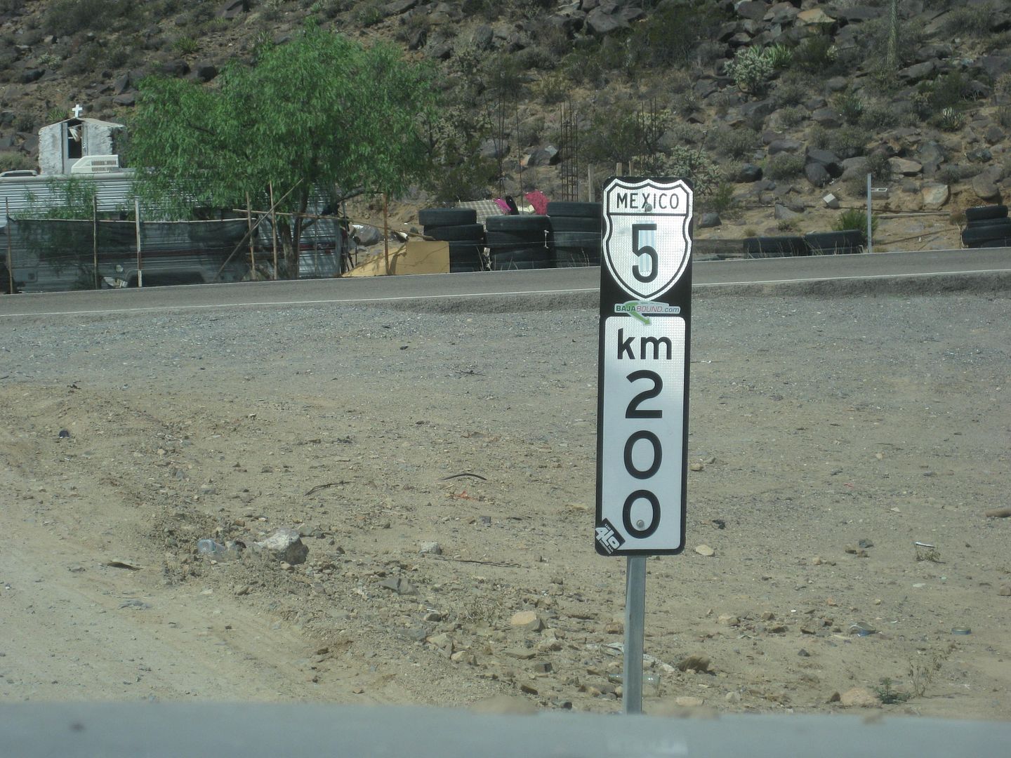
End of Hwy. 5, at Hwy. 1, Laguna Chapala, Aug. 2018.
Just very curious and I don't know when I can get down that way again.
Thank you!
KM 74.5 Puertecitos access
KM 83 Bahia Cristina
KM 84.5 La Costilla
KM 99 Paved Pullout/Viewpoint
KM 103 Nacho's El Huerfanito
KM 117 Okie Landing (site)
KM 127 Campo Delfines (1 km. south of pavement end in July 2012).
KM 133.5 La Poma Restaurant/ Camping (1.0 mi in)
KM 135.5 Punta Bufeo road (1.4 mi. in)
KM 143 Papa Fernandez' road
KM 145 Military Checkpoint
KM 147 Gonzaga Pemex/ Alfonsina's road/ Rancho Grande
KM 149 Camp Beluga (2 mi.), El Sacrificio (4 mi.)
KM 155 Arroyo Santa María bridge
KM 156 Punta Final road
KM 159 Las Palmitas road
KM 167.5 END OF PAVEMENT (2014-2017)
In Aug. 2017, 1 additional km. of paved road was open.
|
|
|
| Pages:
1
2
3
4
5 |


