| Pages:
1
2
3
4
5 |
PaulW
Ultra Nomad

Posts: 3004
Registered: 5-21-2013
Member Is Offline
|
|
My Gps says Gonzaga 147 and end of pavement 167+
Not updated since 11/2016
|
|
|
David K
Honored Nomad
Posts: 64476
Registered: 8-30-2002
Location: San Diego County
Member Is Offline
Mood: Have Baja Fever
|
|
OK, so I have feedback on the Coco's Corner (older route) fork from two Nomads... both putting it at Km. 179.5 and the Las Arrastras bridge at Km.
180.
These are 3-4 kms. more than my previous estimates using satellite measuring from Km. 167.5 (where the pavement had ended from 2014-2017).
I am planning of doing a check next month.
If anyone has new kilometer data to add to this list, please submit it! Thank you!
|
|
|
AKgringo
Elite Nomad
Posts: 5805
Registered: 9-20-2014
Location: Anchorage, AK (no mas!)
Member Is Offline
Mood: Retireded
|
|
I took the turn off at approx. 179.5 (a road work plant is there) then followed Coco's signs to a very smooth dirt short cut to his camp.
On the way out, I followed the old road (rougher than the dirt road) and it came back to the new pavement at km 179!
I was tempted to backtrack to his camp and take the old road south to see where (or if) it also connects to the new pavement, but the homing instinct
keep me headed north!
Anybody know if/where there is a further south access?
By the way, Coco was outside with a flag waving me in, he doesn't get much traffic through there these days!
If you are not living on the edge, you are taking up too much space!
"Could do better if he tried!" Report card comments from most of my grade school teachers. Sadly, still true!
|
|
|
David K
Honored Nomad
Posts: 64476
Registered: 8-30-2002
Location: San Diego County
Member Is Offline
Mood: Have Baja Fever
|
|
179 and 179.5 are just 3/10 a mile apart... both connecting, yes?
|
|
|
David K
Honored Nomad
Posts: 64476
Registered: 8-30-2002
Location: San Diego County
Member Is Offline
Mood: Have Baja Fever
|
|
OK, so I just did measuring on the ArcGIS satellite imagery (which is new enough to show the new highway under construction all the way to Chapala
from Gonzaga...
We have three Nomads who have confirmed Km. 180 is on the Las Arrastras bridge (by the old mill ruins). Measure north 10 kms. is the location of Km.
167, a half km. north of where the pavement drive ended from 2014-2018. It was originally posted as Km. 170, and the Pemex was Km. 150, but they
changed them all to 3 kms. less after a year (to Km. 147 by the Pemex).
Well, this newest section has tacked 3 kms. back on beginning somewhere just beyond to old end-of-pavement which was recently confirmed to be still
just past Km. 167.
It is 10 kms. from the old end-of-pavement to the Las Arrastras bridge... 167+10=180! LOL
OK, continuing south, it is 9 kms. to the canyon where the old road took off for Coco's Corner... now about Km. 189?
It is 11 kms. from the canyon/ old road to almost Hwy. 1 or Km. 201.
This should be Km. 198 when measured from Km. 167, but with the added 3 kms., well... who knows why? Maybe so the contractor gets paid more?
In 2018, it was possible to stay on the new road beyond the detour signs and there was a Km. 168 posted, as the last one in August 2018. It will be
interesting (for me) to see where the magic 3 kms. was inserted!!!
KM. 167 end-of-pavement 2014-2018 (briefly Km. 170)
KM. 180 (167+10) Las Arrastras bridge/ north Coco's road

Km. 189 (167+19) Canyon junction with south Coco's road
Km. 201 (167+31)
[Edited on 3-9-2020 by David K]
|
|
|
PaulW
Ultra Nomad
Posts: 3004
Registered: 5-21-2013
Member Is Offline
|
|
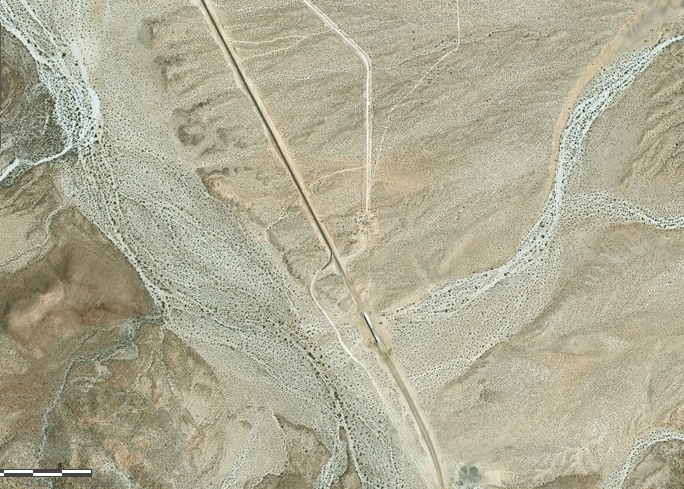
From My travels.
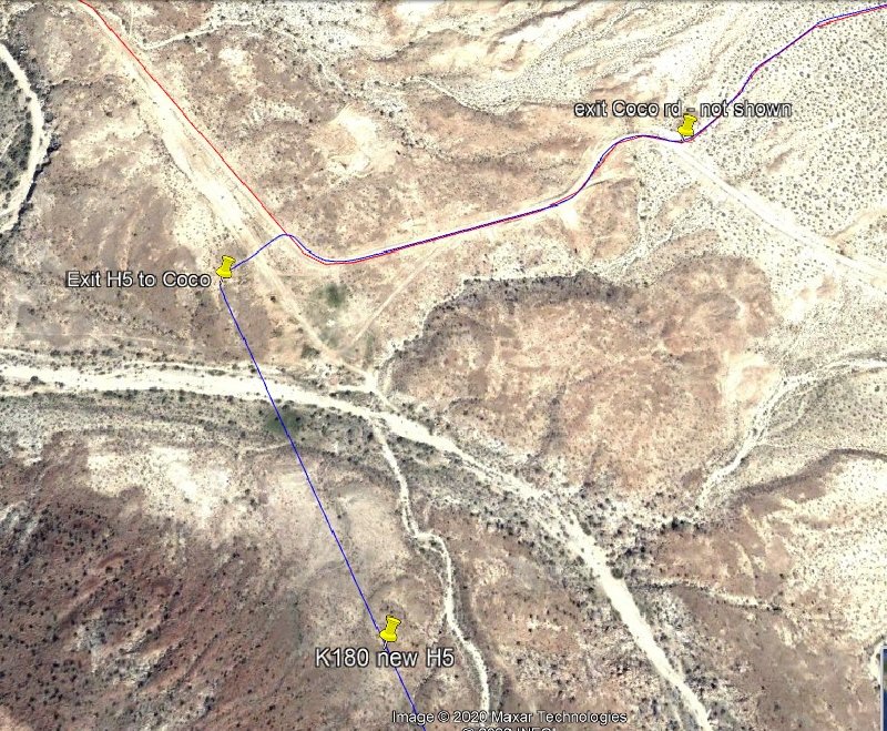
Coco N exit previously documented here
http://forums.bajanomad.com/viewthread.php?tid=89928&pag...
More detail to get to Coco’s place
When I drove the new highway, I saw bogus KM markers and I just gave them WP numbers. Of course, the Kilometer guy has not done his diligent placement
of the signs when I drove thru. Maybe that will happen soon? David’s missing 3 Km remains unresolved.
The KM180 may have been real – If so then the N exit would be KM179.5??
North Exit image
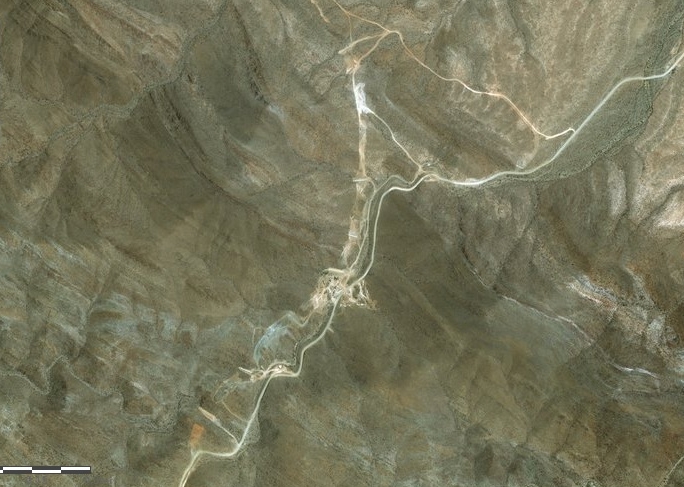
South Exit image
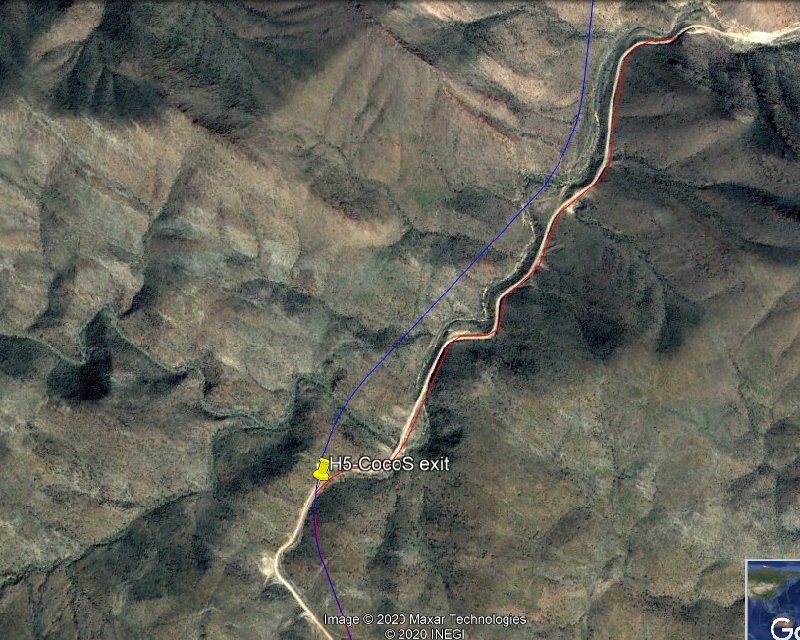
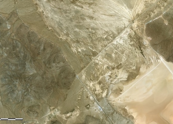
Image from KML attachment
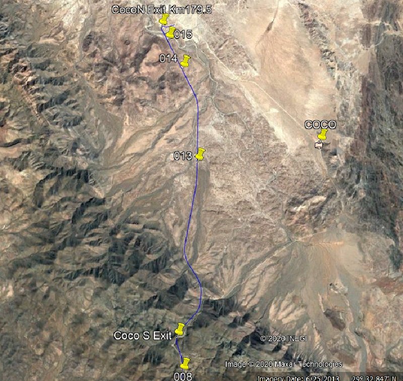
KML File: If you zoom in you can plainly see the dirt road from N exit to S exit.
Here are some coordinates to help:
Coco N Exit 29 32.760, -114 16.206
Coco S exit 29 27.836, -114 20.124
Chapala Km 201? near 29 23.12, -114 22.82
Attachment: New H5-Coco.kml (8kB)
This file has been downloaded 209 times
|
|
|
David K
Honored Nomad
Posts: 64476
Registered: 8-30-2002
Location: San Diego County
Member Is Offline
Mood: Have Baja Fever
|
|
Highway 5, newest section. Kilometer markers and big error!
Thanks to geoffff, the entire newest section of Hwy. 5 has been documented with respect to the kilometer markers and his dash cam.
As I suspected (from earlier reports by John M and PaulW), the kilometer markers south of 167 have 3 extra kilometers added. Geoff has shown that one
kilometer south of 167, the marker is 171! As soon as John and Paul reported the Coco's Corner (old route) junction as being Km. 179.5, I knew that
was three too many kilometers as I had measured the distance in 2018 on the new road plus measured on satellite images!
So, I wonder if (as in other places) the markers eventually get corrected? Did the construction company do this to get paid for 3 more kilometers of
highway work?
The end of Highway 5 at Chapala is now Km. 201.45 (but actually Km. 198.45). This is the distance south from the San Felipe airport road junction
which is 10 kms. south of the downtown traffic circle.
The Hwy. 5 list on the first page of this post has been edited to reflect geoffff's contributions.
[Edited on 3-26-2020 by David K]
|
|
|
David K
Honored Nomad
Posts: 64476
Registered: 8-30-2002
Location: San Diego County
Member Is Offline
Mood: Have Baja Fever
|
|
I just got a request from Blanca, over on my Facebook Baja Land of Missions Group page, to add La Bocana to the Punta Abreojos highway junction
kilometer point... DONE!
Look over the list and if there needs to be any edits, please let me know!  
|
|
|
David K
Honored Nomad
Posts: 64476
Registered: 8-30-2002
Location: San Diego County
Member Is Offline
Mood: Have Baja Fever
|
|
Thanks to AKgringo, who today confirmed the junction of the old road and Hwy. 5, in the canyon (south access to Coco's Corner), is about 200 yards
north of the Km. 190 marker.
The listing was:
KM 189.75 Road east to Coco's Corner & Calamajué (older route). Pretty close!
|
|
|
KasloKid
Nomad
Posts: 326
Registered: 8-29-2009
Member Is Offline
|
|
Quote: Originally posted by PaulW  |
KML File: If you zoom in you can plainly see the dirt road from N exit to S exit.
Here are some coordinates to help:
Coco N Exit 29 32.760, -114 16.206
Coco S exit 29 27.836, -114 20.124
Chapala Km 201? near 29 23.12, -114 22.82
|
Paul, I think the kml file is right on, but the gps coordinates for the North exit seems to be a bit off.
Your coordinates: Coco N Exit 29 32.760, -114 16.206
Using your kml file for the North exit I get: 29 32.968, -114 20.472 which transferred to google earth seems to be right on.
|
|
|
PaulW
Ultra Nomad
Posts: 3004
Registered: 5-21-2013
Member Is Offline
|
|
Always use the KML. That is why I posted it
|
|
|
KasloKid
Nomad
Posts: 326
Registered: 8-29-2009
Member Is Offline
|
|
I agree, one can't go wrong with kml/google earth....
I was about to enter the gps coordinates into my gps and the N exit didn't look right, so I zeroed in on figuring out where it is with your kml file.
Thanks for posting.
|
|
|
David K
Honored Nomad
Posts: 64476
Registered: 8-30-2002
Location: San Diego County
Member Is Offline
Mood: Have Baja Fever
|
|
Made an edit on the Highway 1 junction with Highway 5. Sadly, dropped Coco's Corner distance (only until he moves to the highway), shortened the
distance to Gonzaga, and added the distance to San Felipe.
|
|
|
David K
Honored Nomad
Posts: 64476
Registered: 8-30-2002
Location: San Diego County
Member Is Offline
Mood: Have Baja Fever
|
|
Dec. 2020 Updated Baja South Campos list
I made a list of all the campos I saw a name for on the highway and noted their location during my August 2018 mapping trip.
I posted this on the Baja South Campos Facebook Group page and since then, there have been several updates... all with an * by the name when made by a
Facebook member (area resident).
Today, a couple more edits were made.
Km. 0 Airport Road (6.1 miles from San Felipe traffic circle)
Km. 1 La Hacienda
Km. 6 San Fernando*
Km. 6.5 Residence "Camping" (El Faro Beach)
Km. 6.5+ La Perla del Mar*
Km. 8.5 Villa Marina RV Park.
Km. 8.5 Del Cielo a la Playa*
Km. 9 Campo Lobo*
Km. 11 La Jolla del Mar
Km. 12 Punta Estrella Beach
Km. 14+ Valle de los Gigantes
Km. 15.5 Pancho's
Km. 17 Rancho Los Potrillos
Km. 20.5+ Rancho Percebu.
Km. 26+ Shell Island access road (4WD)
Km. 31 Bahía Santa María/ San Carlos*/ La Misión/ Playa Hermosa
Km. 31.5 Baja Beach Resort
Km. 32 Nuevo Mazatlán
Km. 32 El Sahuaro
Km. 32.5 La Joya*
Km. 33 Playa Linda
Km. 33.5 La Roca
Km. 34 Campo Delicias
Km. 34+ San Pedro.
Km. 35 Fire Station*
Km. 35+ El Vergel
Km. 35.5 Lupita*
Km. 35.5-36 Colonia Delicias (TOWN) See note D, below.
Km. 36 Esmeralda*
Km. 36.5 OM BAJA/ Punta Loma*
Km. 36.5+ La Perlita
Km. 37.5 Diamante
Km. 37.5+ Santa Fe
Km. 38 Casa Las Sirenas*
Km. 38.5+ San Martin
Km. 39.5 Garcia
Km. 39.5+ Playa Mexico
Km. 40+ Rancho Anita
Km. 40.5 Cielito Lindo.
Km. 40.5+ Agua Azul & Cabaña Vieja Restaurante (new)*
Km. 41.5 Campo Cadena
Km. 42+ Campo Jimenez
Km. 42.5 Los Gorditos
Km. 43 San Antonio*
Km. 43.5 Pelicano
Km. 43.5+ Bello Horizonte*
Km. 44 Campo Badilla.
Km. 44.5 Playa Gabriela*
Km. 45 Playa Adriana
Km. 45.5 Mar y Sol
Km. 45.5 Los Morritios
Km. 46 San José
Km. 46.5 Punta Félix
Km. 47 Rudy's Camp
Km. 47.5 San Francisco
Km. 49 Los Pulpos
Km. 49+ Rancho Las Panteras (El Coloradito Parcela 55)
Km. 49.5 Consuelo (at curve in highway)
Km. 51.5 Playa El Sueño
Km. 52.5 Old Puertecitos Road (Score Race Route)
Km. 52.5+ Costa Verde
Km. 54.5 Playa Cristina
Km. 58.5 Los Olivos
Km. 60 Arroyo Matomí
Km. 60.5 El Pozo
Km. 65 El Conquistador
Km. 68.5+ Zimarros
Km. 68.5+ La Violeta.
Km. 70 Campo Cesar*
Km. 72+ La Toba
Km. 73 Cow Patty
Km. 74.5 Puertecitos Road (Octavio's Playa Escondida access)
note D*: In Colonia Delicias is Chelo's Restaurant, South Campos Community Center, Marino’s Restaurant, Josefina’s Laundry and Car Wash, Tita’s
Taco Tuesday Restaurant, Aniceto's Restaurant, Police Station, Amazona Market
* = Edits added from Facebook members
|
|
|
David K
Honored Nomad
Posts: 64476
Registered: 8-30-2002
Location: San Diego County
Member Is Offline
Mood: Have Baja Fever
|
|
It was requested that I include the wording: KM List in the title to help those using Search to find it. You can also remember to
just look for it here in the Road Conditions forum as well as other updates on Baja's roads.
|
|
|
David K
Honored Nomad
Posts: 64476
Registered: 8-30-2002
Location: San Diego County
Member Is Offline
Mood: Have Baja Fever
|
|
Hwy. 1: The GPS for every Km. Marker by Walter Prince
Walter Prince, who raced the Candy Cane Buggy in early Score Baja races, has been working to produce a list of the GPS (long. & lat) for every
kilometer marker in Baja! Personal trips and Google Street View plus other methods were used. I think it is extremely impressive!
This photo by Nomad 'La Tijereta' is from the '95 Baja 1000 of Walter:

Walter initially wished to make a list with GPS of access roads to assist race crews. Our own TW has included many Score access roads on out Nomad
list, so there is a shared interest there.
This list covers Highway 1-D & 1 from the border to Cabo San Lucas:
Attachment: 00000 Hwys 1 and 1D - Sent out Dec 2020.xlsm (104kB)
This file has been downloaded 159 times
|
|
|
Bajabus
Senior Nomad
Posts: 892
Registered: 8-30-2002
Location: Elias Calles B.C.S. or NC USA
Member Is Offline
Mood: My friends..it's good.
|
|
Hwy 19 Todos to Cabo, KM82 Bajabus's place.........
|
|
|
David K
Honored Nomad
Posts: 64476
Registered: 8-30-2002
Location: San Diego County
Member Is Offline
Mood: Have Baja Fever
|
|
WOW!!!
How are you, Max???
19 years ago, on Christmas:

[Edited on 12-30-2020 by David K]
|
|
|
Bajabus
Senior Nomad
Posts: 892
Registered: 8-30-2002
Location: Elias Calles B.C.S. or NC USA
Member Is Offline
Mood: My friends..it's good.
|
|
I remember that visit! Good to see you're still on your toes with instant and relevant picture posting skills We are heading back down to the property in a few weeks. Let me know if you need KM marker sightings. We used to
be KM 79 but every once and a while they recalibrate the markers to reflect road changes. As I recall eliminating the "curva del soldato" south of us
and the S turns south of Rancho Nuevo was one of the times they did this and then again with the 4 lane. We are heading back down to the property in a few weeks. Let me know if you need KM marker sightings. We used to
be KM 79 but every once and a while they recalibrate the markers to reflect road changes. As I recall eliminating the "curva del soldato" south of us
and the S turns south of Rancho Nuevo was one of the times they did this and then again with the 4 lane.
Good to see all the same faces and some new ones.
"Preventive war was an invention of Hitler. Frankly I would not even listen to anyone seriously that came and talked of such a thing."
Dwight David Eisenhower
|
|
|
David K
Honored Nomad
Posts: 64476
Registered: 8-30-2002
Location: San Diego County
Member Is Offline
Mood: Have Baja Fever
|
|
Super, is Lynn still letting you tag along? Here she is with the Baja Bus:

|
|
|
| Pages:
1
2
3
4
5 |


