| Pages:
1
2
3
4 |
PaulW
Ultra Nomad
    
Posts: 3113
Registered: 5-21-2013
Member Is Offline
|
|
Coco road search
Roads near Coco's
I noticed the the Almanac has many missing roads that are shown on my GPS map.
Consulting INEGI H11D29 I see a road leading N from the Punta Calamajue road east of Coco's. It goes to Punta Final.
Anybody taken that road??
FYI, when I did my INEGI search I stumbled across other interesting maps.
H11D18 Gonzaga
H11D28 Turquesa & Mission S Maria.
H11B88 Hurefanito
|
|
|
David K
Honored Nomad
        
Posts: 65399
Registered: 8-30-2002
Location: San Diego County
Member Is Offline
Mood: Have Baja Fever
|
|
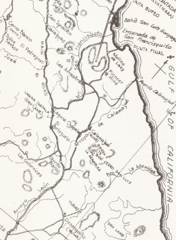
The one south from Molino de Lacy that passes the Pioneer Mine?

I traveled only a couple miles of it in 2002... was more of a motorcycle route. Back in the late 1950s, it was a preferred route over the deep sand
track along Arroyo San Francisquito.
From 1956:

|
|
|
David K
Honored Nomad
        
Posts: 65399
Registered: 8-30-2002
Location: San Diego County
Member Is Offline
Mood: Have Baja Fever
|
|
This photo was taken from the hill at Molino de Lacy... facing south. The road going south, right of my truck, along the right side of the photo, is
it...

|
|
|
willardguy
Elite Nomad
     
Posts: 6451
Registered: 9-19-2009
Member Is Offline
|
|
but i've seen no evidence of it continuing over the mountain?
|
|
|
David K
Honored Nomad
        
Posts: 65399
Registered: 8-30-2002
Location: San Diego County
Member Is Offline
Mood: Have Baja Fever
|
|
By anything bigger than m/c anymore you mean?
|
|
|
willardguy
Elite Nomad
     
Posts: 6451
Registered: 9-19-2009
Member Is Offline
|
|
who's done it on a scoot?
|
|
|
David K
Honored Nomad
        
Posts: 65399
Registered: 8-30-2002
Location: San Diego County
Member Is Offline
Mood: Have Baja Fever
|
|
Kacey Smith from Alfonsina's... it's in her book... plus all the tracks I saw.
|
|
|
motoged
Elite Nomad
     
Posts: 6481
Registered: 7-31-2006
Location: Kamloops, BC
Member Is Offline
Mood: Gettin' Better
|
|
I think Kacey calls it The Mine Trail...
Don't believe everything you think....
|
|
|
David K
Honored Nomad
        
Posts: 65399
Registered: 8-30-2002
Location: San Diego County
Member Is Offline
Mood: Have Baja Fever
|
|
Yes, as it was how the ore got from the Pioneer Mine to Molino San Francisquito (Molino de Lacy today)... and that was not using motorcycles!
It was a very tough road in the 60's and 70s... Mike Humfreville even wrote a chapter about it when he drove it in his Land Cruiser!: http://math.ucr.edu/ftm/bajaPages/Correspondents/MikeHumfrev...
|
|
|
4x4abc
Ultra Nomad
    
Posts: 4453
Registered: 4-24-2009
Location: La Paz, BCS
Member Is Offline
Mood: happy - always
|
|
it's a medium difficult 4x4 road
I have done it more times than I can count
last time in May 2014
some cool mining stuff out there
https://carlosnpainter.smugmug.com/Events/Manly-Men-Baja-201...


Harald Pietschmann
|
|
|
Phil S
Super Nomad
   
Posts: 1205
Registered: 10-28-2003
Member Is Offline
Mood: After 34 years. Still in love w/ my wife
|
|
wouldn't want to be traveling during an earthquake in this area (last pic) Interesting route. Don't think I'd want to venture here in my Yukon XLT,
even though I love 'tough' routes. This looks too challenging. What do you mean, 4x4, regarding the mine reference? "stuff" Any pic's of the
'stuff'.? Would love to see them here. (save me a trick attempt)
|
|
|
David K
Honored Nomad
        
Posts: 65399
Registered: 8-30-2002
Location: San Diego County
Member Is Offline
Mood: Have Baja Fever
|
|
Quote: Originally posted by Phil S  | | wouldn't want to be traveling during an earthquake in this area (last pic) Interesting route. Don't think I'd want to venture here in my Yukon XLT,
even though I love 'tough' routes. This looks too challenging. What do you mean, 4x4, regarding the mine reference? "stuff" Any pic's of the
'stuff'.? Would love to see them here. (save me a trick attempt) |
Starting here at Punta Final, then click on the right arrow to advance through the photos of the road and mine: https://carlosnpainter.smugmug.com/Events/Manly-Men-Baja-201...
|
|
|
StuckSucks
Super Nomad
   
Posts: 2369
Registered: 10-17-2013
Location: Pacific Plate
Member Is Offline
|
|
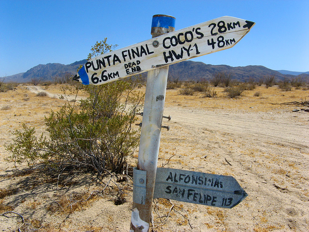
This was taken 10 years ago, but I believe this was at the intersection of the road from Punta Final to Highway 5, and that "straight" north/south
road (south of Molina Lacy).

|
|
|
4x4abc
Ultra Nomad
    
Posts: 4453
Registered: 4-24-2009
Location: La Paz, BCS
Member Is Offline
Mood: happy - always
|
|
love those old Baja road signs
the most creative is probably the Santa Barbara/San Miguel sign at La Junta

[Edited on 3-9-2016 by 4x4abc]
[Edited on 3-9-2016 by 4x4abc]
Harald Pietschmann
|
|
|
toronja
Nomad
 
Posts: 134
Registered: 2-1-2015
Location: Eugene, OR
Member Is Offline
|
|
Cool beans, guys, thanks for the mini tour. We are not quite that adventurous in the 4x4 department (working with a steadfast but bulky Chevy
trailblazer here). I'm curious if one attempted a round trip from the north side to the mine and back, would that be a little less hairy? Or is the
mine and road north still in pretty rough terrain?
|
|
|
willardguy
Elite Nomad
     
Posts: 6451
Registered: 9-19-2009
Member Is Offline
|
|
now im really lost...I thought we WERE talking about going in from the north?
|
|
|
toronja
Nomad
 
Posts: 134
Registered: 2-1-2015
Location: Eugene, OR
Member Is Offline
|
|
Ah crap, no that was my bad, Willard. The first couple of comments were regarding from the south and I just got all bamboozled. I guess my question
would thus be the reverse - from the south to the mine and back.
|
|
|
willardguy
Elite Nomad
     
Posts: 6451
Registered: 9-19-2009
Member Is Offline
|
|
I could be wrong...but what I've assumed is the other end (calamajue road junction) has mining going on and guards on duty, that you can see from the
calamajue road. this within the last couple years.
|
|
|
David K
Honored Nomad
        
Posts: 65399
Registered: 8-30-2002
Location: San Diego County
Member Is Offline
Mood: Have Baja Fever
|
|
Quote: Originally posted by toronja  | | Ah crap, no that was my bad, Willard. The first couple of comments were regarding from the south and I just got all bamboozled. I guess my question
would thus be the reverse - from the south to the mine and back. |
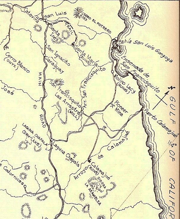
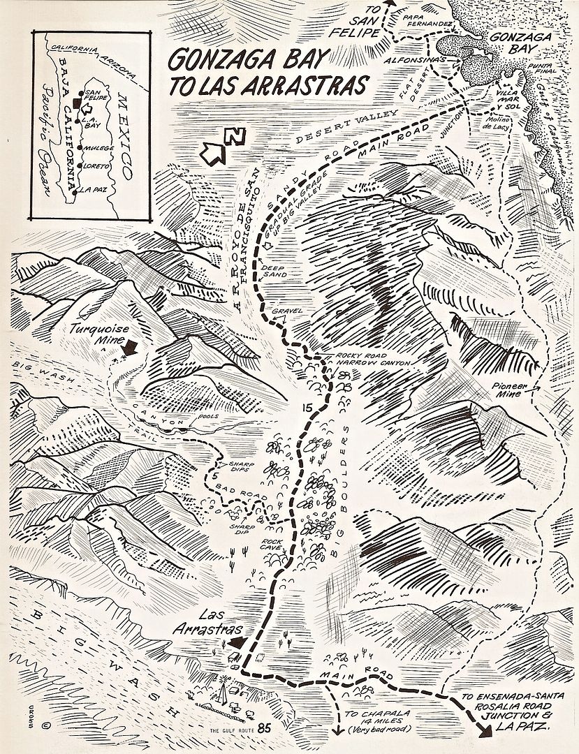
Why not just make a loop... much of the west side is now paved, however.
Note "Pioneer Mine" on the east side road. Look at 4x4abc's photos to see the road and 4 wheeled vehicles on it...

Map by Cliff Cross, 1970
|
|
|
David K
Honored Nomad
        
Posts: 65399
Registered: 8-30-2002
Location: San Diego County
Member Is Offline
Mood: Have Baja Fever
|
|
Google Earth is your trip planning friend... Bing Maps has even newer satellite images of many areas.
Timothy Walker found dynamite in a shed near the south end of the road at one of the (then) semi-active gold mines. While TimsBaja.com is no longer on
the Internet, I have all his trip pages saved and can show them if interested. Tim and his friends Robert and Robert did a lot of exploring around
Coco's Corner and Gonzaga Bay 10-15 years ago.
|
|
|
| Pages:
1
2
3
4 |

