| Pages:
1
2
3
4
5 |
Jinete Viejo
Junior Nomad

Posts: 88
Registered: 1-23-2017
Member Is Offline
|
|
I made a track of it a few years ago (traced it on Google Earth and converted it to GPX format with GPS Visualizer) and attempted to ride it. Shortly
after the first hill climb after leaving the wash after the ruins one of my riding buddies dropped his bike and put a hole in the radiator. Being the
elder statesman in the group (68), I had already decided it wasn't my kind of trail, and having seen the type of trail it was, was never tempted to
ride it again. We have called it the "Radiator Springs Trail" ever since. I was wondering if the guys who rode it posted any tracks to verify that we
are talking about the same trail.
|
|
|
4x4abc
Ultra Nomad
Posts: 4165
Registered: 4-24-2009
Location: La Paz, BCS
Member Is Offline
Mood: happy - always
|
|
here is the last track I recorded hiking the trail:
http://baja101.com/Baja-GPS/CaminoRealSantaMaria.kmz
Harald Pietschmann
|
|
|
TMW
Select Nomad
Posts: 10659
Registered: 9-1-2003
Location: Bakersfield, CA
Member Is Offline
|
|
Below pin 13 in David's picture is a road or wide trail. Is that the bull dozer road? If so why did they not follow the actual trail?
|
|
|
PaulW
Ultra Nomad
Posts: 3008
Registered: 5-21-2013
Member Is Offline
|
|
Harald,
thanks for that link.
Probably wont hike it, but I will save it just in case.
=======
|
|
|
4x4abc
Ultra Nomad
Posts: 4165
Registered: 4-24-2009
Location: La Paz, BCS
Member Is Offline
Mood: happy - always
|
|
Quote: Originally posted by TMW  | | Below pin 13 in David's picture is a road or wide trail. Is that the bull dozer road? If so why did they not follow the actual trail?
|
that is a track Fred Hampe made - it connects to a well used indian trail
who knows what plans Fred had
it is reported that he wanted to continue to Gonzaga
the dozed track in Google Earth is severely washed out by now
I drove it in 1986 to the top - that is no longer possible
[Edited on 7-11-2020 by 4x4abc]
Harald Pietschmann
|
|
|
4x4abc
Ultra Nomad
Posts: 4165
Registered: 4-24-2009
Location: La Paz, BCS
Member Is Offline
Mood: happy - always
|
|
it's an easy hike
the entrance on the Gonzaga side can only be found with the GPS track
mission side is easier to find
[Edited on 7-11-2020 by 4x4abc]
Harald Pietschmann
|
|
|
del mar
Banned
Posts: 1057
Registered: 7-23-2016
Location: the cantina of course
Member Is Offline
Mood: lil' fuzzy
|
|
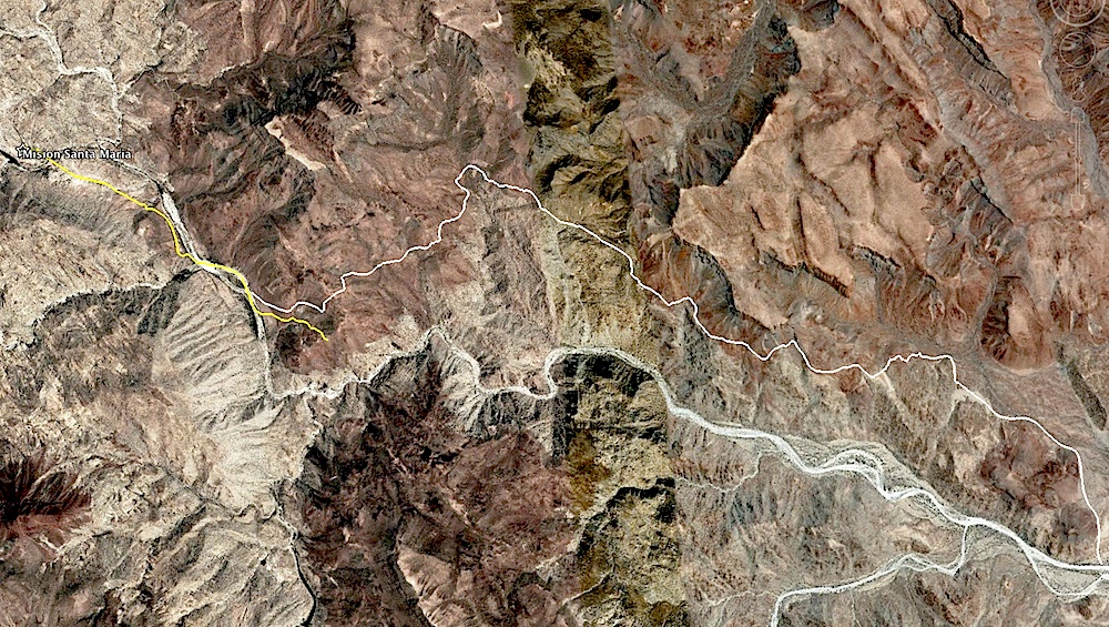
im not sure what im looking at, the yellow line is the bulldozer road, the thin white line is the original trail? whats the thick white line that
looks like a riverbed?
|
|
|
David K
Honored Nomad
Posts: 64486
Registered: 8-30-2002
Location: San Diego County
Member Is Offline
Mood: Have Baja Fever
|
|
Harald, it was Fred Hampe, not Arturo Grosso responsible for the road east from Santa Ynez to the mission and 2 miles beyond.
Del Mar, the white line is El Camino Real; yellow line is Fred's bulldozed road, and the white sand is the arroyo.
|
|
|
David K
Honored Nomad
Posts: 64486
Registered: 8-30-2002
Location: San Diego County
Member Is Offline
Mood: Have Baja Fever
|
|
| Quote: Originally posted by 4x4abc |
it's an easy hike
the entrance on the Gonzaga side can only be found with the track
mission side is easier to find |
I have photos of the trail where it leaves the white sand arroyo, and gps. I found it in 2002 and returned to hike to the mission in 2003. We ran low
on daylight and turned back about 2/3 of the way to the mission.
|
|
|
del mar
Banned
Posts: 1057
Registered: 7-23-2016
Location: the cantina of course
Member Is Offline
Mood: lil' fuzzy
|
|
why can't you just walk or ride up the arroyo all the way to the mission?
|
|
|
David K
Honored Nomad
Posts: 64486
Registered: 8-30-2002
Location: San Diego County
Member Is Offline
Mood: Have Baja Fever
|
|
Boulders, and the steep trail near the end of the canyon where the cliff or waterfall makes the trail necessary from the canyon to the end of the
bulldozed road up on top.
|
|
|
4x4abc
Ultra Nomad
Posts: 4165
Registered: 4-24-2009
Location: La Paz, BCS
Member Is Offline
Mood: happy - always
|
|
following the missionary trail is an easy 3 hour hike to the mission from the Las Palmitas water hole
following the canyon it is a tough, boulder hopping, cliff climbing 6 hour adventure
if it is your first trip count on 7 to 8 exhausting hours
all numbers one way
the easy start:

and it gets rougher:
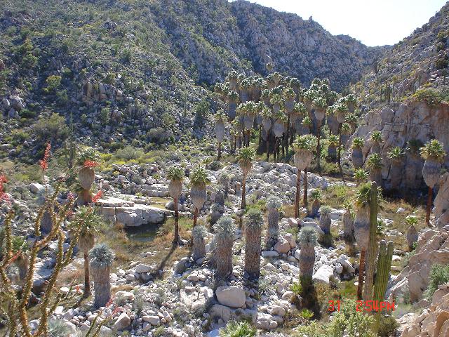
then it gets tight:

don't have pictures of where it get even wilder
[Edited on 1-30-2018 by 4x4abc]
[Edited on 1-30-2018 by 4x4abc]
[Edited on 1-30-2018 by 4x4abc]
[Edited on 1-30-2018 by 4x4abc]
[Edited on 1-31-2018 by BajaNomad]
Harald Pietschmann
|
|
|
David K
Honored Nomad
Posts: 64486
Registered: 8-30-2002
Location: San Diego County
Member Is Offline
Mood: Have Baja Fever
|
|
Yes, that is the canyon route... Good photos Harald!!
The Franciscans had the new route made because the canyon was too dangerous for mule teams with cargo (or passengers). That new ECR route is Harald's
white line on his satellite map (and my 13 waypoints on my images above).
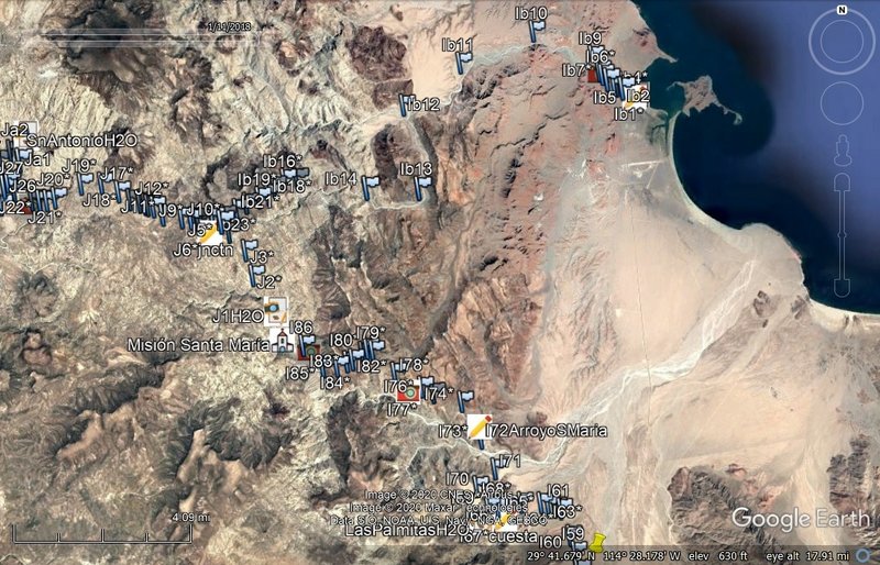
I found it in November 2002. Here are my photos from my website www.vivabaja.com. I returned the following year to go further.
Here is where the Franciscan ECR begins in Arroyo Santa María (just east of the canyon entrance):
Here it is!!! N29°41.733' W114°28.175' (Map Datun: NAD27)

Three cattle trails cross Arroyo Santa Maria and converge at the only place where a climb out of the arroyo is possible. This was on my second day
searching, and the reward was worth it!

This second climb takes you out of the Santa Maria river valley and into a higher side valley heading northwest. Ocotillos line the trail just ahead.
In case you had any doubts...

This sign says it all! It was laying along the El Camino Real about a half mile up from Arroyo Santa Maria. I continued hiking, with a big smile on my
face!

Looking back to the southeast. This was the Baja Highway, before automobiles.

This is where I turned back. The temptation to continue was high, but Chris was waiting for me back at the truck. In fact, the trail ahead gets much
rougher and would require better preparation and at least one overnight, for the round trip.
The following year, my son and I returned to hike to the mission. We didn't start early enough and late November days are short, so we ran out of
daylight.
2003:


Chris was motivated to get to the mission, but the trail disappeared on us here.
We had just enough daylight to get back to my truck, so it was time to turn back. We really didn't want to.
*We would learn from Don Jorge (who followed our lead a week later and made it to the mission) that every place the trail vanished, it could be found
by going uphill (northward) and towards the west.
From 2003:
GPS Directions (map datum NAD27 Mexico)
Take Hwy. 5 south 7.4 miles from Rancho Grande, turn west: 29°41.094'/ 114°24.566'
3.2 miles west of Hwy. 5, go straight where most traffic curves left for Las Palmitas: 29°41.278'/ 114°27.639'
0.8 miles from above, park at huge boulder: 29°41.68'/ 114°28.20'
Hike to north bank of Arroyo Santa Maria to: 29°41.733'/ 114°28.175' elev. 609' (ECR-1)
Go northwest and climb out of valley, note ocotillos.
Along left side of side valley: 29°42.374'/ 114°28.566' elev. 741' (ECR-2)
On first padre built switchback up: 29°42.669'/ 114°28.937' elev. 906' (ECR-3)
On a ridge, trail continues northwest: 29°42.671'/ 114°29.425' elev. 1308' (ECR-4)
On the Camino Real: 29°42.748'/ 114°29.482' elev. 1391' (ECR-5)
Crossing ridges and little mesas: 29°43.008'/ 114°29.967' elev. 1477' (ECR-6)
Drop along side of ridge, trail narrow: 29°43.074'/ 114°30.128' elev.1610' (ECR-7)
End of today's hike just beyond this last clear sign of the old trail: 29°43.141'/ 114°30.189' elev. 1702' (ECR-8)
Junction of ECR & bulldozed road: 29°43.126'/ 114°31.753' elev.1413'
(End of bulldozed road, on canyon ridge: 29°43.033'/ 114°31.556' elev. 1,615' )
Mision Santa Maria: 29°43.891'/ 114°32.794' elev.1628'
[Edited on 1-30-2018 by David K]
|
|
|
willardguy
Elite Nomad
Posts: 6451
Registered: 9-19-2009
Member Is Offline
|
|
they sure could have saved themselves a bundle of work and just built the mission at las palmitas, they already have a chapel there!

|
|
|
4x4abc
Ultra Nomad
Posts: 4165
Registered: 4-24-2009
Location: La Paz, BCS
Member Is Offline
Mood: happy - always
|
|
I always loved that painted rock
Harald Pietschmann
|
|
|
David K
Honored Nomad
Posts: 64486
Registered: 8-30-2002
Location: San Diego County
Member Is Offline
Mood: Have Baja Fever
|
|
Riding El Camino Real on a motorcycle, east from Mission Santa María:
|
|
|
bajaric
Senior Nomad
Posts: 602
Registered: 2-2-2015
Member Is Offline
|
|
Great thread! Some expert moto riding for sure in the (long) video.
I can clearly see the old trail in the moto video, at least parts of it. Since Mission Sta. Maria was abandoned in only a year or two, they must have
never really finished the trail. Very rocky country. Hiking overland in that terrain is very tedious. This trail was a briefly used shortcut from
El Camino Real in the high country down to the landing at Gonazaga. After the trail was abandoned, the much better trail down Calamajue Arroyo
continued to be used, and has been to this day --
I think Ken C. was joking when he said someone towed a trailer down the canyon.
|
|
|
David K
Honored Nomad
Posts: 64486
Registered: 8-30-2002
Location: San Diego County
Member Is Offline
Mood: Have Baja Fever
|
|
| Quote: Originally posted by bajaric | Great thread! Some expert moto riding for sure in the (long) video.
I can clearly see the old trail in the moto video, at least parts of it. Since Mission Sta. Maria was abandoned in only a year or two, they must have
never really finished the trail. Very rocky country. Hiking overland in that terrain is very tedious. This trail was a briefly used shortcut from
El Camino Real in the high country down to the landing at Gonazaga. After the trail was abandoned, the much better trail down Calamajue Arroyo
continued to be used, and has been to this day --
I think Ken C. was joking when he said someone towed a trailer down the canyon. |
Hi Ric,
This is fun stuff for me, as it is both my favorite parts of historical Baja and I have hiked on some of the mission road in the area.
The mission of Santa María was active from 1767 (after moving from Calamajué) into 1774 (the final census at Santa María).
However, El Camino Real (Baja's first transpeninsular highway) still passed through that valley with the mission until automobiles appeared and
mandated a road in a less difficult route than the mission trail.
The Franciscans and Dominicans never built roads in the same fashion as the Jesuits had. They were inclined to just go with the natural terrain and
only did roadbuilding where it was absolutely necessary. The Jesuits engineered their road in straight lines with switchbacks when the terrain
mandated it. That is why the Jesuit Camino Real is so easy to spot on Google Earth to this day.
The post-Jesuit Camino Real was nothing more than a cattle trail in size, with a few exceptions. The trail from San Borja north was opened just over a
year before the Jesuits were removed, so you don't see much of the beautiful road work north of San Borja as there wasn't enough time.
The trail the motorcycles are on was made by the Franciscans after Junípero Serra ordered a better road (than the one he traveled in the canyon) be
made. Serra also ordered to be created, the cargo trail or as he called it, the Antelope Spring trail to Gonzaga Bay. This was for the construction of
San Fernando mission and more direct communication to the new missions beyond Santa María. That trail bypasses Santa María, to the north and joins
El Camino Real just east of the peninsular divide (about 4 miles from the mission, towards Santa Ynez). Ships from Loreto or the mainland offloaded
supplies at Gonzaga Bay, where the warehouse was (foundation outlines still visible), destined for San Fernando and beyond. The cargo trail can be
seen in person as you drive towards Santa María, near where it ends below the high point.
The Camino Real has always used Calamajué Canyon since it reached that far north in October 1766.
You can enjoy the great work done at spotting the Camino Real (and Cargo Trail to Gonzaga Bay's warehouse) at www.caminorealbaja.com using Google Earth.
[Edited on 7-10-2020 by David K]
|
|
|
bajaric
Senior Nomad
Posts: 602
Registered: 2-2-2015
Member Is Offline
|
|
Interesting! Somehow I thought that main El Camino Real ran through the high country near present day Hwy 1 by Catavina, with a branch that dropped
down to Gonzaga and back up to Sta Maria. Wrong again.
I realize now that overgrown goat track alongside Arroyo Sta. Maria was "the" El Camino Real, between San Borja and San Fernando. The trail was
actually east of Santa Ynez, from the info on the ECR link you posted. Hard to imagine they got much cargo up that to supply the northern missions, I
think they were also supplied by sea on the Pacific side. I believe they landed supplies at San Diego, and possibly at other Padre Ports further
south.
|
|
|
David K
Honored Nomad
Posts: 64486
Registered: 8-30-2002
Location: San Diego County
Member Is Offline
Mood: Have Baja Fever
|
|
Yes, they did ship supplies by boat to San Diego. However, going against the current northward was not as fast or easy as sailing to Gonzaga Bay and
then loading burros or mules for the 3-day trip to San Fernando and beyond. The warehouse at Gonzaga and the Camino Real was probably used a lot more
by the Dominicans and the Spanish for their northern Baja activities.
Perhaps easier to view on this page than the www.caminorealbaja.com map is the Howard Gulick ECR map of this area... It is what Harry Crosby used initially...

Full size version on my website, here: http://www.vivabaja.com/ECR/elcaminoreal3.html
The only difference between what Howard saw as ECR and what the Canadian couple found is between Calamajué and San Francisquito (by Las Arrastras).
It may very likely be two routes of ECR that parallel each other.
From Harry Crosby's 1974 book, The King's Highway in Baja California:
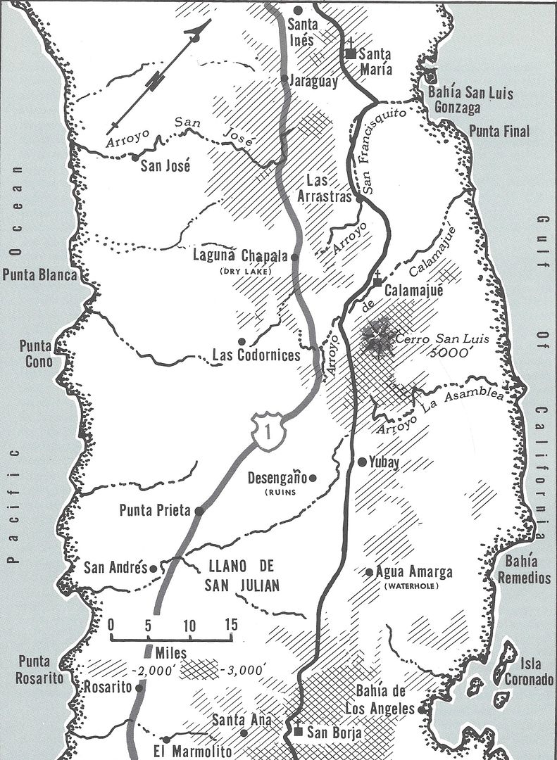
Here are the maps of the area, that Harry Crosby commissioned, in 1977...

|
|
|
| Pages:
1
2
3
4
5 |


