| Pages:
1
2
3
4
5 |
bajaric
Senior Nomad

Posts: 603
Registered: 2-2-2015
Member Is Offline
|
|
I learn something every day. Pretty scarce in the way of grass for animals around those parts, although burros and mules could be fed on the green
shoots of shrubs, offering an advantage over horses. Even today, "grass fed" beef in some parts of Baja is actually "shrub fed". The climate may
have also been a little cooler and wetter in those days.
Also, I think that part of the trail that went past mission Sta Maria was abandoned prior to the advent of the automobile. In 1905 Nelson described
riding past Cerro Pedregroso, near present day Hwy. 1, then down to the historic San Francisquito well at Las Arrastras, staying to the west of and
bypassing mission Sta Maria, as best as I can determine.
[Edited on 7-12-2020 by bajaric]
|
|
|
David K
Honored Nomad
Posts: 64488
Registered: 8-30-2002
Location: San Diego County
Member Is Offline
Mood: Have Baja Fever
|
|
Hi Ric,
On my website, I have a zoomable map of the Nelson expedition: https://collections.lib.uwm.edu/digital/collection/agdm/id/3...
It isn't super accurate, but gives some idea of his route and the mission sites (Santa María and Calamajué). The dashed line would seem to be El
Camino Real, except that it is shown going from Santa María to Onyx (an early name for El Mármol). The ECR went from Santa María to Agua Dulce.
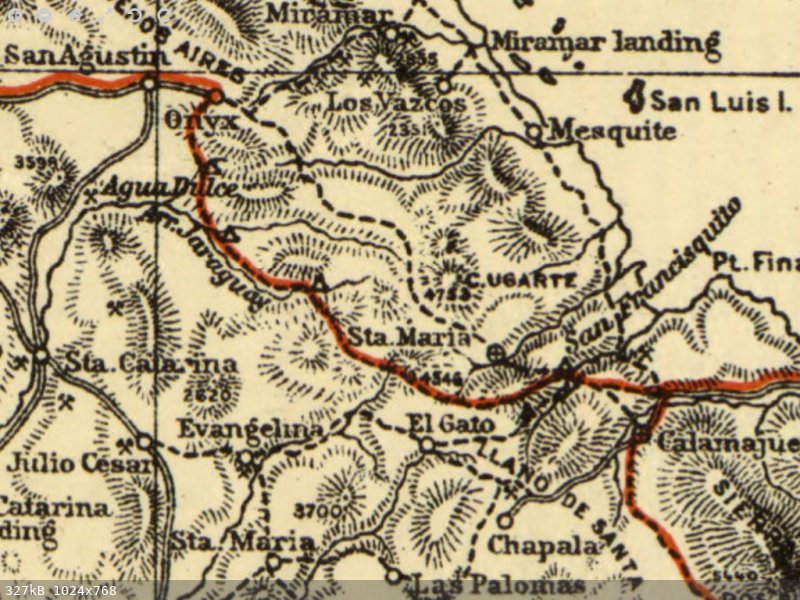
Nelson's route is highlighted on this 1919 map:
|
|
|
bajaric
Senior Nomad
Posts: 603
Registered: 2-2-2015
Member Is Offline
|
|
Hi DK, I had to crack open my copy of Nelson's Lower California, Natural Resources, to see if I could figure out the route they took, from near
Pedregroso, across the divide and down to the historic San Francisquito well in 1905.
"About 4 miles beyond Cerro Pedregoso (going south) ... at this point a dim trail branched off to left (east) .. and we followed it about 8 miles to
the crest of the slope, at an elevation of 2,800 feet forms the peninsular divide From the top of the divide an abrupt descent leads to a lower
plain extending to the shore of the gulf, which was in plain view....
"A good trail leads from the divide down the east slope to a small, strongly mineralized stream flowing through a series of pools in the smooth rock
bottom of a broad canyon. Thence the canyon narrowed and leaving it crossed some low hills ..we reached the San Francisquito wash. Here a well, some
old arrastras, and many other signs marked the long deserted mining camp of San Francisquito"
I figured out it must have been where you and "Baja Angel" were, here:
http://www.vivabaja.com/207/
It was Arroyo Turquesa, scene of many a nomad adventure! By 1905, mining activities in the area were probably responsible for the creation of this
trail, which bypassed the old El Camino Real that went from Mssion Sta Maria down Arroyo Santa Maria to the San Francisquito well, probably because it
was an easier route for those arriving from the north.
thus ends my deep dive into Baja historic trivia, for now....
thanks for helping me to correct a couple of errors in my research.
[Edited on 7-13-2020 by bajaric]
|
|
|
David K
Honored Nomad
Posts: 64488
Registered: 8-30-2002
Location: San Diego County
Member Is Offline
Mood: Have Baja Fever
|
|
Good morning, Ric!
Yes, it is pretty obvious that they came down into La Turquesa Canyon! Our Nomad hero, Roy "The Squarecircle" being the first documented ascent of
that grade in a Land Rover LR3! Witnessed by Tom, TW (TMW) and his brother, Bill.
Once Elizabeth (aka 'Baja Angel') and I photographed the top of the grade, east of El Pedregoso, there was great interest in getting a
four-wheeled-vehicle across from Hwy. 1 to Hwy. 5, there. Ken Cooke attempted with one of his Jeep groups, but it was Roy and Tom who found a way from
the end of the road at the turquoise mine to the bottom of the switchback grade up to the top.
Roy and Blanche slowly climbed to the top and out to Hwy. 1 while TW and Bill drove around via the 'normal' route.
http://forums.bajanomad.com/viewthread.php?tid=30726
In Feb 2011, TW found a pair of videos so we can see the grade (going down) and the bottom of the grade to the pools:
From 2008:


|
|
|
rich t
Nomad
Posts: 102
Registered: 4-18-2016
Member Is Offline
|
|
I just read Kens article about us making it from hwy 1 to hwy 5, we did not go all the way thru, we found the old camino and made it to the top where
you could overlook and see Gonzaga, there is no way to drive a vehicle past where we were. I did talk to Malchom Smith several years ago about it, he
said he could not ride it but his son made it on a moto, claims it is easier going from Gonzaga to the mission going up hill. We did have to fill in
one hole about 8 feet deep to get up there, I think that is where my friend lost his wallet.
|
|
|
Ken Cooke
Elite Nomad
Posts: 8921
Registered: 2-9-2004
Location: Riverside, CA
Member Is Offline
Mood: Black Trans Lives Matter
|
|
Here are a few videos from our Feb 2019 trip along the Pioneer Trail. I was either speaking to David (on front of me) or with Ru KinKon (over the
radio).
|
|
|
Ken Cooke
Elite Nomad
Posts: 8921
Registered: 2-9-2004
Location: Riverside, CA
Member Is Offline
Mood: Black Trans Lives Matter
|
|
Broken down, waiting for Triple A - Mr. Rich T.
|
|
|
rich t
Nomad
Posts: 102
Registered: 4-18-2016
Member Is Offline
|
|
New mounts, now Baja bullet proof.
|
|
|
Ken Cooke
Elite Nomad
Posts: 8921
Registered: 2-9-2004
Location: Riverside, CA
Member Is Offline
Mood: Black Trans Lives Matter
|
|
I believe it. Are you running a jounce shock in conjunction as well, Rich?
|
|
|
rich t
Nomad
Posts: 102
Registered: 4-18-2016
Member Is Offline
|
|
No, just Fox resevoir, I had just picked that Jeep up not long before the Pole Line trip and did not have very good mounts for the shocks, built new
mounts and recessed the upper shock tower in the frame.
|
|
|
K7BVT
Junior Nomad
Posts: 56
Registered: 8-24-2012
Member Is Offline
|
|
MC video Santa Maria to Gonzaga
Anyone know where to find the you tube video of the guys that rode bikes out of Santa Maria to Gonzaga? ://www.youtube.com/watch?v=7EL-eg5C4Uk
|
|
|
David K
Honored Nomad
Posts: 64488
Registered: 8-30-2002
Location: San Diego County
Member Is Offline
Mood: Have Baja Fever
|
|
Quote: Originally posted by K7BVT  | | Anyone know where to find the you tube video of the guys that rode bikes out of Santa Maria to Gonzaga? ://www.youtube.com/watch?v=7EL-eg5C4Uk
|
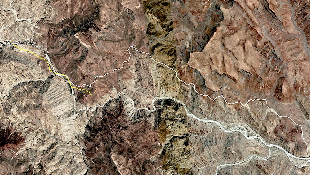
Sadly, that video is no longer available... too bad! It showed how crazy it was to ride a motorcycle on El Camino Real from the Mission Santa María
valley down to the desert by Gonzaga Bay:
https://www.youtube.com/watch?v=7EL-eg5C4Uk
On this map from 4x4abc, note the white line showing the post-1769 El Camino Real and is what the motorcycles used. The yellow line shows part of the
1767-1769 route (which used the canyon then up to the east end of the yellow line):
[Edited on 11-13-2020 by David K]
|
|
|
PaulW
Ultra Nomad
Posts: 3009
Registered: 5-21-2013
Member Is Online
|
|
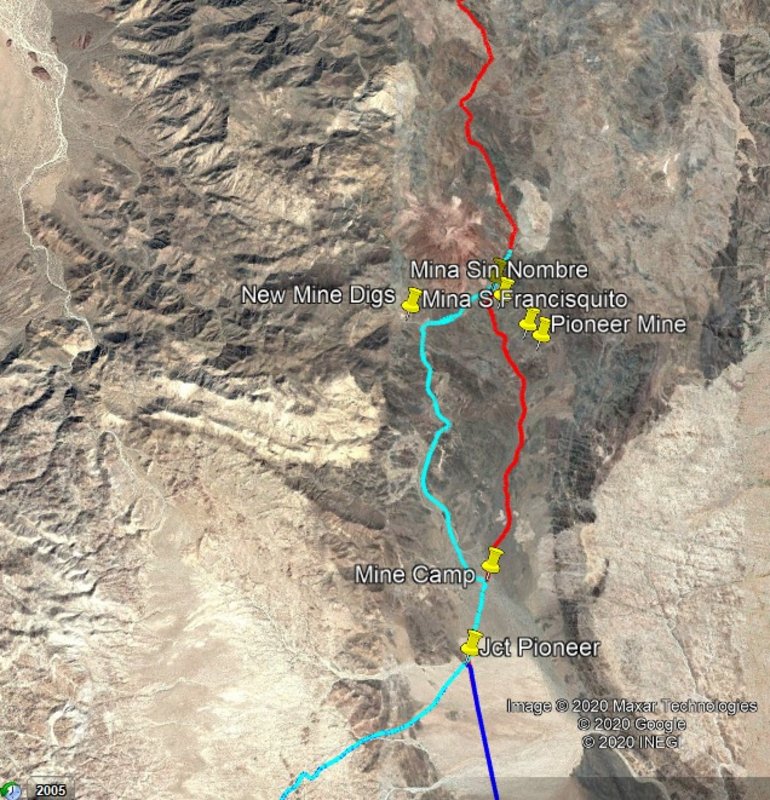
Lots of discussion on the Pioneer Mine trail. I collected various tracks I made in that general area for you all to view.
Note that both tracks are shown near the mines. The western loop has driving issues but can be negotiated with a little discovery and spotting. All
the other tracks can be driven with a lifted 4x4 and for certainly with a trail bike.
The trail is one of the more difficult trails that many of us have driven in Baja.
I cannot post the KML or GPX (GPS) files as they are to big
|
|
|
4x4abc
Ultra Nomad
Posts: 4165
Registered: 4-24-2009
Location: La Paz, BCS
Member Is Offline
Mood: happy - always
|
|
save the kml as kmz and you can post it
Harald Pietschmann
|
|
|
4x4abc
Ultra Nomad
Posts: 4165
Registered: 4-24-2009
Location: La Paz, BCS
Member Is Offline
Mood: happy - always
|
|
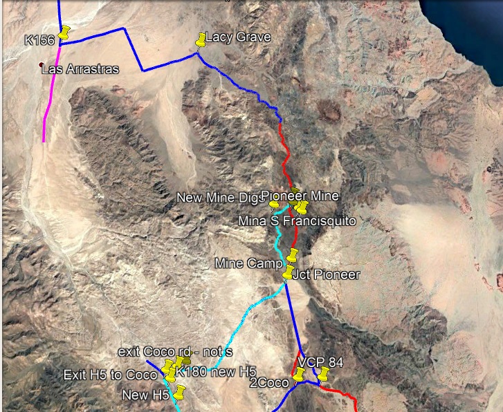
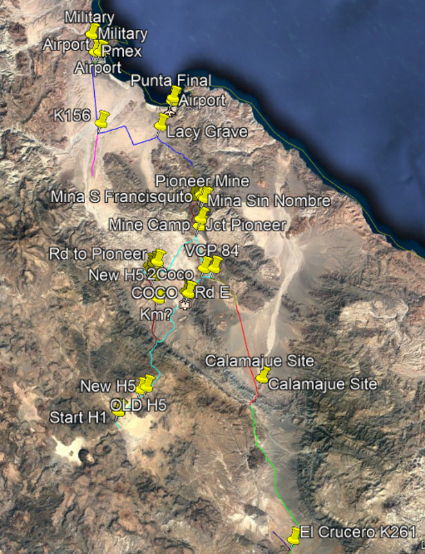
here is the pioneer trail

Harald Pietschmann
|
|
|
TMW
Select Nomad
Posts: 10659
Registered: 9-1-2003
Location: Bakersfield, CA
Member Is Offline
|
|
Is somebody going to do the pioneer trail soon? I'm game.
|
|
|
David K
Honored Nomad
Posts: 64488
Registered: 8-30-2002
Location: San Diego County
Member Is Offline
Mood: Have Baja Fever
|
|
Harald, is the black line a drivable route or just a foot trail?
I always found it interesting that the early government roadbuilders going south from Gonzaga went into a canyon with seemingly no exit, back in the
late 1950s...

|
|
|
PaulW
Ultra Nomad
Posts: 3009
Registered: 5-21-2013
Member Is Online
|
|
=== =
Don't know how.
That kml is a composite of 6 merged tracks I only know how to save each file alone.
|
|
|
PaulW
Ultra Nomad
Posts: 3009
Registered: 5-21-2013
Member Is Online
|
|
| Quote: Originally posted by David K | Harald, is the black line a drivable route or just a foot trail?
I always found it interesting that the early government roadbuilders going south from Gonzaga went into a canyon with seemingly no exit, back in the
late 1950s...
===v==
I drove that straight road heading north from the Pioneer track. It was made by a grader and is in good condition, but crosses a couple of washes that
requires slowing down. At the north end it comes to the Rancho Grande property cross fence and a left turn takes one to Hwy 5. Kinda steep up to the
pavement. |
|
|
|
David K
Honored Nomad
Posts: 64488
Registered: 8-30-2002
Location: San Diego County
Member Is Offline
Mood: Have Baja Fever
|
|
| Quote: Originally posted by PaulW | | Quote: Originally posted by David K | Harald, is the black line a drivable route or just a foot trail?
I always found it interesting that the early government roadbuilders going south from Gonzaga went into a canyon with seemingly no exit, back in the
late 1950s... |
===v==
I drove that straight road heading north from the Pioneer track. It was made by a grader and is in good condition, but crosses a couple of washes that
requires slowing down. At the north end it comes to the Rancho Grande property cross fence and a left turn takes one to Hwy 5. Kinda steep up to the
pavement. |
Yes, the straight road from the Rancho Grande runway south is the original road made about 1959. My question was about Harald's black line from the
south end where the Gulick map shows it ends and over the mountain to the road network closer to Coco's Corner.
A 1960 map by Howard Gulick:
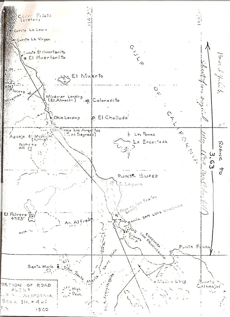
[Edited on 11-16-2020 by David K]
|
|
|
| Pages:
1
2
3
4
5 |


